Category Archives: Photos

Mise Tales Five

If you do not know what Mise Tales are then please see Mise Tales One.
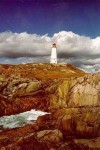
Louisburg Lighthouse - photo Chris Mills


From the Cape Breton Post Canada’s First Lighthouse is a Long Way from its Glory Days. Historic Louisburg lighthouse on Cape Breton Island, Nova Scotia is another Canadian lighthouse declared surplus by Fisheries and Oceans and in need of repair and some tender loving care (TLC).

**************************

Jobsolete: The lighthouse keeper of Triple Island

This week (Wednesday April 11, 2012), Daybreak is running a series called “Jobsolete,” exploring careers that are fading away. Today, George Baker speaks to Richard Rose, one of the few lighthouse keepers still keeping watch.

[audio:https://ccanadaht3.com/wp-content/uploads/2012/04/daybreaknorthbc1_20120411_98103_uploaded.mp3|titles=Lightkeeper Interview]

****************************

The last Misc Tale today is from the Philippines, where I am on holidays right now. It is from the Philippines Star website and is entitled:

Cape Bolinao lighthouse in Pangasinan closed to tourists
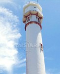
Cape Bolinao Lighthouse

PANTAR, Pangasinan, Philippines – For decades, the Cape Bolinao lighthouse atop Punta Piedra Point here has guided vessels.

The lighthouse, built in 1905 by Filipino, British and American engineers, is one of the five lighthouses in the country and the second tallest, next to the Cape Bojeador lighthouse in Burgos, Ilocos Norte.

It was supposed to be a major tourist destination in the country during the holidays. But today, with the advent of the global positioning system (GPS), the 30.78-meter tower that had guided vessels en route to Hong Kong, Japan and the United States for several decades, has been closed to visitors. . . . more
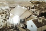
Life on Pine Island c. 1950s

Here is another story from Ms. Juanita (Swanson) DuLong. She was a young girl on most of these stations, but living there, and hearing stories from her parents, she has created   lighthouse memories from the 1950s time. Her older stories are found here and here.

Her husband Roy scanned some nice photos of Pine Island station, but unfortunately they are way too small to show here. When he has time to make larger ones, I will add them.

Roy sent some more scans, but they are limited, but I have posted them because they show details not available before – e.g. the A-frame highline setup.

*************************

Pine Island houses - photo Juanita Swanson

There may be somewhere in the world a place foggier than Pine Island lighthouse, but it’s hard to believe. The horn was often on for days on end, and became only another background noise. A lighthouse tender could arrive in clear weather, and radio that Pine was under a doughnut of fog. Continue reading Life on Pine Island c. 1950s

Recent Storm on Cape Scott 2012

Cape Scott on a good day - photo Harvey Humchitt, Jr.

Every winter the West coast of Canada is pounded by storms with Hurricane Force winds (scale 12 on the Beaufort Scale).

Below you can read what the lightkeeper at Cape Scott lighthouse posted for this April 02, 2012 storm. The keeper, Harvey Humchitt, Jr. posted this information on his Facebook page.

02:05 PST MONDAY APRIL 2, 2012 HURRICANE FORCE WIND WARNING FOR CAPE SCOTT.
Wind southwest 10 to 20 knots (18 to 37km/hr) increasing to southeast 20 to 30 knots (37 to 55km/hr) this afternoon and to 30 to gales 40 knots (55 to 74km/hr) early this evening. Wind increasing to southeast storm force 50 to 60 knots (92 to 111km/hr) near midnight except HURRICANE FORCE 65 knots (120km/hr) near the headlands Monday morning. Wind diminishing to southwest 25 to gales 35 (46 to 64km/hr) near noon Monday.

04:43 PST MONDAY APRIL 2, 2012 Hurricane is here full force hittin us hard at 80 knots 150km/hr, and a ton of rain

07:34 PST MONDAY APRIL 2, 2012 We were hit by almost 200km/hr winds that took out two storm doors, the crown on a spare house, the siding on a spare house and flooded our engine room. Winds are still gusting to 180km/hr, and horizontal rain.

11:38 PST Final Hurricane status report, winds hit 230 km/hr, lots of heavy rain that dumped 40mm of rain and the seas hit near 30ft. Damage done, two screen doors lost, siding on one house gone, crown on roof…gone, flashing for roofing…..gone, 3 trees fell, bassement in spare house flooded, engine room flooded and a stick punctured a hole in our sat dish for the tv but still works. In all….a typical British Columbia North Coast Hurricane. This is probably the last Hurricane force wind we will see now until the fall.

I do not think I have ever seen a storm like this when I was on the lighthouses – at least one  quite as strong in intensity. Climate change? 

Below are some photos Harvey made after the storm had gone through. Note the stormy seas and ragged clouds. Remember, these were made after the storm passed over. During the storm you cannot even get outside the house sometimes.  (All photos credited to Harvey Humchitt, Jr.

[nggallery id=48]

Winter Visitors Come Flying In

Snowy Owl - photo Wikipedia

In the winter time when it became very cold on the British Columbia coast we almost always had fly-in visitors from the far north land on Mcinnes Island. These were the large Snowy Owls from the Arctic.

When the cold weather hit with lots of snow then the owls had no food available in the northern parts of Canada and Yukon and they then migrated south for the winter. We did not see them every year, but that could have been because we lived on an island. I know they have been recorded as far south as Vancouver, BC, so it is not an unusual event.

On the island we had the usual collection of Bald Eagles that used to sit in the trees. The eagles did not bother our four Siamese cats at all, but the Snowy Owls were a different thing. Anything that moved and was brown in colour was fair game! We did have mink and otters too, but when a cat is available, why go for something harder. Continue reading Winter Visitors Come Flying In

Mise Tales Four

If you do not know what Mise Tales are then please see Mise Tales One.

I found this cute video on the Internet about a lighthouse keeper. In all the stories they seem to have problems to solve. It’s also true with real life lightkeepers too.

 [media url=”https://ccanadaht3.com/wp-content/uploads/2012/03/Lighthouse_752x423_500.flv” width=”400″ height=”350″]

*************************************

Lighthouses in operation have declined due to the expense of maintenance. Let us take an artistic photograph of it for lifetime memory. – Digital Photography Review/Challenges 

Lots of lovely large photos of lighthouses at the link above – worldwide lighthouses – beautiful photos!

 [nggallery id=46] Continue reading Mise Tales Four

Lighthouse Photos by Cyril R. Littlebury c. 1922-1932

Photos of British Columbia lighthouses by Cyril R. Littlebury in the years 1922 to 1932 with thanks to Dudley R. Booth for permission to publish – please visit Dudley’s new website at Historic Photos. There are many more photos there besides lighthouses.

When Dudley Booth developed some old negatives his father gave him he found a treasure trove of scenes from 1920s and 1930s Vancouver. 

[nggallery id=43]

  Continue reading Lighthouse Photos by Cyril R. Littlebury c. 1922-1932

Song – Lighthouse by Runrig (with videos)

A friend found this for me, and sent me the links. It is nice song, and the photos are so beautiful that I just had to share it. There are two versions with different photos. I have inserted the lyrics in between the two videos so they are available for both.

The first video has the lyrics embedded over the photos, while the second video has no lyrics visible. Enjoy!

Lighthouse

This world’s not my home
I’m a stranger to the storm
Save me, save me
Where the race is quickest
The tide runs strong Continue reading Song – Lighthouse by Runrig (with videos)

Do You Have a Photo of Me Mid-1978?

– Rand Grant (relief keeper on Triple Island June – July 1978)

Melville Island - looking NW from Triple - photo Rand Grant (Flickr)

The story is in reference to the photo at right, Rand writes: 

The large Island is Melville. Prince Rupert lies just beyond this. The tanker is on it’s way into Prince Rupert Port. One of the deepest and busiest on the west coast of British Columbia. 

One evening back in ’78 [while stationed on Triple Island], I noticed an Alaskan Cruise ship on it’s way by. I walked up to the roof; it was a beautiful summer evening; I was curious, so started waving my arms over my head, back and forth. I actually witnessed that ship light-up with so many flash-bulbs that it made me laugh.  Continue reading Do You Have a Photo of Me Mid-1978?

Website – Rough Radio – Wireless on the BC Coast

This is a promotion for my friend Frank Statham’s website Rough Radio – Wireless on the British Columbia Coast.

As I started off collecting lighthouse keeper names for genealogy records, Frank started with a collection of photographs, and with his past work as a radio operator, his interest was sparked into creating a website to help people remember the early days of radio on the BC coast. He also has been keeping a list of station personnel which you will find here.

The quotes below from Frank’s website show that lighthouses came first, but with the advent of radio, the two worked closely together, in fact sometimes so close together that they were on the same station – e.g. Estevan Point  or Pachena Point. 

“At the end of the 19th Century, the west coast of Canada was dangerous place for the movement of vessels.  There was little European settlement along the coast north of Victoria.  The only navigational aids for vessel traffic consisted of a scattering of lighthouses.”

“The 1907 Canadian Dominion Government, in an effort to provide some measure of safety for mariners, implemented a plan to provide a life saving trail along the Juan de Fuca Strait Vancouver Island, lifeboat stations, and wireless radio stations.  The first five wireless stations, Vancouver, Victoria, Pachena Point and Estevan Point were all operational by January 1908.”   Continue reading →

Some photo samples from Frank’s website below:

 [nggallery id=17]

Lighthouse Photos from Emails

As this website is about lighthouses, many people send me emails with photos and links. This past week I received three such emails so I will combine them all in one as they all contained photos of lighthouses. – JC

Email 1. Peggy’s Cove, Nova Scotia During Hurricane Irene (text from the email)

Hurricane Irene 2011

These pictures show the seas that came ashore after Hurricane Irene (August 20 – 29, 2011) went by.  Many of you have been to Peggy’s Cove, Nova Scotia, Canada. Well, the RCMP had the road shut down – only people who lived in the village could enter. The road was closed on both sides of the cove; waves were coming in over the road at about 10 meters, 30 feet for those that are not bi-measurement. The last hurricane that went by actually moved the restaurant at Peggy’s Cove a couple of feet.  These pictures were taken with a telephoto lens from the hill beside the cove. The pictures were taken by a friend of a neighbour (will the friend of the neighbour please come forward and introduce yourself – nice photos) – JC Continue reading Lighthouse Photos from Emails