Amphitrite Lighthouse is located on the west coast of Vancouver Island, British Columbia, Canada. It is automated and closed to the public, but one can get close enough for photos. The photos above (all 80 of them) were taken by my friend Ghislain Bonneau, a west coast painter and photographer. Continue reading Amphitrite Lighthouse
Tag Archives: Amphitrite
Lighthouse History – 51 (1927-02-04 – 1927-06-29)
The following extracts taken from early Victoria, British Columbia (BC) newspapers are credited to Leona Taylor for her excellent work in indexing the papers. Full information can be found here: ”Index of Historical Victoria Newspapers“, 2007-09.
Please Note: December 20, 2012 – I am continuing the series with this Lighthouse History #51 because the newspapers have now been indexed up to 1932. I quit posting at #50 as the extracts only went to 1926. They have now been extended from 1927 to 1932 so I will sift through the data for anything lighhouse! So far, a lot of it appears to be obituaries.
Henry Georgeson, 91, retired keeper of Active Pass lighthouse died Feb 3. [funeral Feb 10, 12…] [Colonist, 1927-02-04, p. 4]
Died May 9, 1927 at V, Captain James Christensen, 86. Resident here in 1864, aged 21, born in Denmark. He worked his way out in a cargo ship from Liverpool. Here he tried shore pursuits until he joined Surprise as mate, and in that capacity in 1869 came in contact with the loss of US bark John Bright, off Hesquiat… [see earlier accounts]
Christensen was afterwards on schooner Alert, with Captain William Spring, and continued trading on the West Coast for some years. He was a pioneer in the sealing trade. His last journey to the west coast was to take material for the erection of Cape Beale lighthouse in 1876. He was successively in command of Beaver, Pilot, tugs Alexander and Lorne, and in 1891 became pilot for Victoria and Nanaimo districts [8 years].
In 1868 he married Mary Linklater, and leaves son, Andrew. His other son, Captain James Christensen, succeeded him as commander of Lorne and afterwards ran other tugs out of Victoria until 1894. In that year he lost his life with all the crew of steamer Estelle, which foundered off Cape Mudge. IOOF. Pallbearers: Captains J E Butler and J Gosse, E More, J Woodriff, W McKay, R Lawson. May 11, 14 – How Captain Christensen Conquered the Doubters… Family plot, H 093b094 E 23. [Colonist, 1927-05-08*] Continue reading Lighthouse History – 51 (1927-02-04 – 1927-06-29)
Reprint – The Lighthouses of British Columbia
In February 2012 I wrote an article on the seawater sample collecting from the BC lighthouses here My story discussed the duties and .trials a lightkeeper had while obtaining the samples. This story details the use of the information collected from a scientist’s point of view.
********************************
The Lighthouses of British Columbia
Not only are British Columbia’s lighthouses picturesque, and important for navigational purposes, but they also collect oceanographic data! You can access sea surface temperature (SST) and surface salinity data at the following website:
www.pac.dfo-mpo.gc.ca/science/oceans/data-donnees/lighthouses-phares/index-eng.htm
This website also has photographs of the lighthouses. (See below.)
Figure 1. Race Rocks (48.180 N, 123.320 W). Photo credit: Fisheries and Oceans Canada. Photograph obtained from: http://www.pac.dfo-mpo.gc.ca/science/oceans/data-donnees/lighthouses-phares/index-eng.htm
Figure 2. Amphitrite Point (48.550 N, 125.320 W). Photo credit: Fisheries and Oceans Canada. Photograph obtained from: www.pac.dfo-mpo.gc.ca/science/oceans/data-donnees/lighthouses-phares/index-eng.htm
I’ve compiled and plotted some of the data from the Race Rocks and Amphitrite Point lighthouses. Race Rocks (Figure 1) is near Victoria, while Amphitrite Point (Figure 2), on the west coast of Vancouver Island, is closer to Bamfield. The data plotted in Figure 3 are monthly averages for October, covering the years 1936 to 2011. The plot shows an evident contrast in SST and surface salinity between the two sites.
Figure 3. October averages for surface salinity plotted versus October averages for sea surface temperature. The data are from two different lighthouses: Race Rocks (48.180 N, 123.320 W) and Amphitrite Point (48.550 N, 125.320 W). Race Rocks is near Victoria, while Amphitrite Point is on the west coast of Vancouver Island. Data are not plotted for 1940 and 2007, because of missing values. Graphics produced with R (R Core Team, 2012). Data source: Fisheries and Oceans Canada, www.pac.dfo-mpo.gc.ca/science/oceans/data-donnees/lighthouses-phares/index-eng.htm (accessed Oct. 9, 2012).
A peculiarity of the lighthouse data is that they are not collected at the same time every day, as explained on the lighthouse data website: “Sampling occurs at or near the daytime high tide” (Fisheries and Oceans Canada, 2012).
If you want data for ocean bottom temperature and salinity (as opposed to surface temperature and salinity), such data are available through NEPTUNE Canada, and through the VENUS network (NEPTUNE Canada, 2012; VENUS, 2012).
Citations
Fisheries and Oceans Canada. 2012. Website. Accessed Oct., 9, 2012:http://www.pac.dfo-mpo.gc.ca/science/oceans/data-donnees/lighthouses-phares/index-eng.htm
NEPTUNE Canada, 2012. Website: www.neptunecanada.com
R Core Team, 2012. R: A language and environment for statistical computing. R Foundation for Statistical Computing, Vienna, Austria.
VENUS network, 2012. Website: www.venus.uvic.ca
Lighthouse History – 43 – Amphitrite (1914-01-06 to 1915-03-26)
The following extracts taken from early Victoria, British Columbia (BC) newspapers are credited to Leona Taylor for her excellent work in indexing the papers. Full information can be found here: ”Index of Historical Victoria Newspapers“, 2007-09.
As I was collecting this information from the newspaper archive website, I noticed that many articles were in consecutive order and applied to Nootka Light, so I collected them all together here. It is a bit long, but interesting, as it describes the building of a lighthouse from the ground up as they say. Take note of the dates at the end of each article. it surely was not done overnight. More extensive information can be obtained from the actual scanned copies of the newspapers themselves on the above website.
******************************
Dominion Government Steamer lighthouse tender Estevan will clear Victoria for Ucluelet, with the lifeboat on board. Yesterday the craft was hoisted aboard and stowed on the foredeck, where it will remain until discharged at Ucluelet, where everything is in readiness for the reception, and with her arrival there will be tried out by the lifesaving crew.
After discharging the new power boat Estevan will take the lifeboat, at present stationed there, to Clayoquot, and the surf boat now at that point, will be brought South to Clo-oose. Estevan will also establish a gas lighted beacon at Channel Rk, Barkley Sound, to replace the one which broke adrift recently in a Southeast gale.
While away from Port Estevan will also establish a temporary white light at Amphitrite Point, to mark the point, pending the construction of a new lighthouse. The unattended light at Amphitrite was carried away last week in a gale. [Colonist, 1914-01-06]
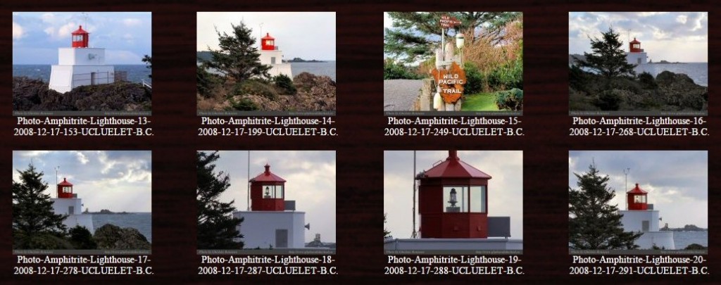
Plans for the new lighthouse to be established at Amphitrite Point, Ucluelet Arm, have just been received at the local offices of the Marine Dept. Work on the new structure will be started early in the new year and the contract will be rushed to completion as quickly as the weather will allow. The plans call for a reinforced concrete tower, which, when completed, will be 30′ in height.
The tower will be surmounted by a 5th order lens, giving an adequate flashing radius for that section of the coast. Lighthouse tender Leebro will be used in transporting the construction materials from Victoria to Amphitrite Point, and it is expected that she will make her 1st trip there after the Xmas holidays. [Colonist, 1914-12-15]
Construction materials for the new lighthouse at Amphitrite Point will be taken on Leebro’s next trip North. As soon as possible after the New Year, Leebro, Captain Hunter, laden with cement and other materials that will go towards the construction of the concrete tower, will leave port for Amphitrite Point. It is expected that she will be almost exclusively engaged in transporting material to the site until such time as the structure is completed.
Dominion Government Steamer Estevan, Captain Barnes, flagship of the fleet, is due to put to sea on Mon next with supplies for West Coast Vancouver Island. She will first proceed to Estevan to carry out some work at West Coast Vancouver Island Stations. [Colonist, 1914-12-30]
Within the next 2 weeks the new lighthouse at Amphitrite Point will be blinking its powerful rays seaward to the North of Barkley Sound.
Lighthouse tender Leebro, Captain Hunter, in port yesterday from West Coast Vancouver Island, brought the news that the lighthouse is in the final stages of completion.
When Leebro left there the workmen were putting the final touches to the 2nd storey of the lighthouse, and practically everything was in readiness for placing the lantern in position. The structure, which is built of solid concrete, is 2-storeys in height, and will be surmounted by a 5th order light. The construction of the lighthouse has been carried out in a remarkably short space of time.
Captain Hunter says the recent trip to West Coast Vancouver Island was made under most favorable conditions, there being a total absence of gales, usually frequent at this season.
Leebro is now loading and will put to sea with the last consignment of supplies for the light on Fri. [Colonist, 1915-02-24]
Mariners are officially notified that the new concrete lighthouse, at Amphitrite Point, West Coast Vancouver Island, to replace the former lighthousewhich was washed away during a heavy gale last fall, has been put into operation. [Colonist, 1915-03-26]