Tag Archives: weather

Mise Tales Forty-Seven

For an update on what a Mise Tale is then please see Mise Tales One.

As mentioned earlier on the front page of my website, any photos or cartoons, or short bits of information, when it is removed from the front page, will also be included again later in the next next Misc Tales posting. That way you can keep track of it, search for it, or copy it.

************************************

Wind Map
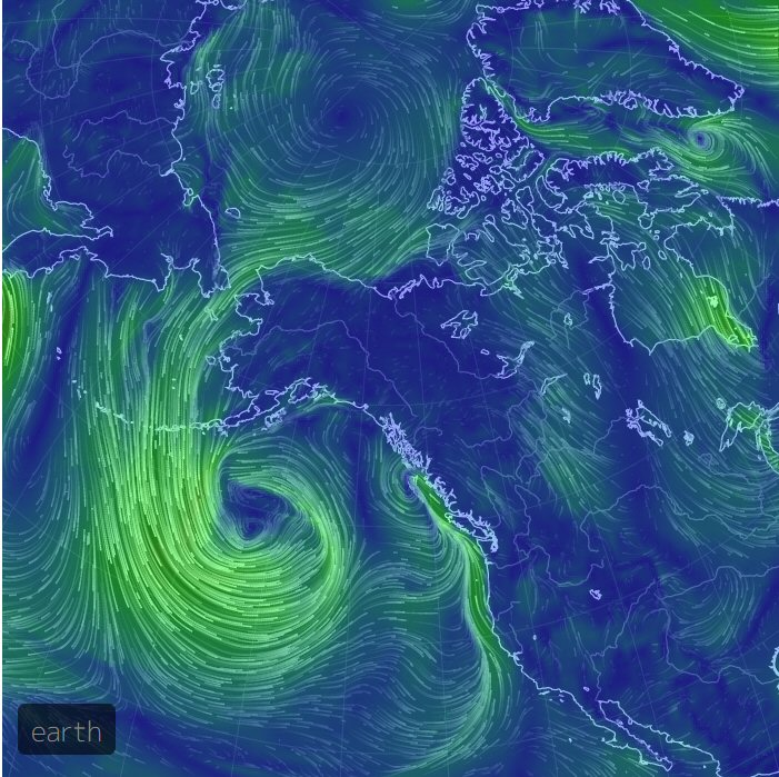
On October 18, 2014, a large storm was hitting the British Columbia, Canada coastline. The photo above shows the winds as a visualization of global weather conditions, forecast by supercomputers, updated every three hours. Click the photo for more recent details. Move around the map with your mouse. Zoom in also. Check out the menu in the lower left corner for more information.

****************************** Continue reading Mise Tales Forty-Seven

Animated Map of Global Wind Conditions

One of the duties of a lighthouse keeper is the reporting of the weather for the boats, aircraft and also for forecasting. One of the things reported is the wind speed. From all around the world the wind speed is recorded and reported from countless weather stations.

Below are two screenshots of a new webpage showing a:

Visualization of global weather conditions as forecast by supercomputers. Weather data, generated from numerical models at Earth.NullSchool.net,…

earth wind map_01
Earth wind map showing winds over the Atlantic Ocean


earth wind map_02
Earth wind map showing winds around the Philippines, with special consideration for the Tropical Depression in the lower right (the tight swirl)

The photos above are static screen shots – the website is live! Navigate around just like in Google Earth using your mouse and the scroll wheel. Zoom in, zoom out. Enjoy!


Mise Tales Sixteen


For an update on what a Mise Tale is then please see Mise Tales One.

Lighthouse Greeting Cards

Earlier in November I reprinted two stories on the Cape Canaveral lighthouse (story 1 & story 2) by Judy Lovell. One thing you might have missed on her website are her Greeting Cards featuring lighthouses, antique maps and lighthouse history.

Greeting Cards for Online Ordering : A selection of greeting cards of various Everglades, Birds and Lighthouse images laid out with a soft background on the inside. These 5×7 cards come printed on luxuriously thick card stock, folded in the middle. They’re matte with a UV coating that gives the outside a soft sheen. The inside is smooth enough to pen a personal message and each card includes a matching envelope. These cards are shown print ready and so half of it looks upside-down. Don’t worry! That’s just how our printers read them and we promise they will look perfect in-person.

Here is a story on one of the cards: The “Big Diamond” – New Hillsboro Light Greeting Card in Antique Map Series (photo on left above) Continue reading Mise Tales Sixteen

A Trip to Scarlett Point c. 1973

– as told to me by Jean (Bartle) Konkle (daughter of relief keeper Albert Bartle)

I remember going to Scarlett Point one Easter Weekend, the first time we (my husband Rodger and I) had been there. We traveled ten long dusty hours up mostly gravel road to Port Hardy . There we planned to catch a fish boat out to the island. But although the harbour at Port Hardy was glass, nobody would take us out.

Although we couldn’t afford it, we had only the long weekend, so we attempted to charter a helicopter, but they wouldn’t go out in this weather.

32 foot fishboat - photo Ray Morgan

We went back to the fish docks, where we found a 32 foot fish boat to take us out. It leaked diesel, and I lost my breakfast.

When we got to Scarlett, Ralph and Brian came out to meet us in the station boat. The waves were so high, we had to wait until the gunwhales of the fish boat were even with the 14 footer to transfer across. Continue reading A Trip to Scarlett Point c. 1973

Weather Observing – a Large Part of the Job

Note:- How to obtain an up-to-date weather report from a BC lighthouse

McInnes with weather instruments (lower half) – photo John Coldwell

One of the duties on most of the lighthouse stations, and especially on McInnes Island, up to 2003, was the reporting of local weather (weather visible in the immediate area of the station) to Environment Canada (EC) – earlier called the Atmospheric Environment Service (AES) – for re-broadcast to boaters, pilots and climatologists.

This became even more important after the Tropical Storm of October 1984 hit the British Columbia coastline.

Extreme Tendency November 05, 1988 – scan Glenn Borgens

Every three hours during the day, starting at around three o’clock in the morning we would collect the information on sky condition, visibilty, wind speed and direction, rain/snowfall, wet and dry bulb temperatures plus maximum and minimum temperatures, station pressure and tendency (whether pressure was rising or falling and how rapidly), and sea and swell height. This was then recorded on AES forms or in a notebook depending on the station. Not all stations reported or had the instruments for all observations. These records were forwarded to AES every month along with a Climate Summary for the month. Continue reading Weather Observing – a Large Part of the Job

The Storm of October 1984

The article I posted earlier about the storm at Cape Scott brought to mind a story I had written for the old website. This story (below) brought to the attention of the government one of the important attributes of BC lighthouse keepers – they are on-site!

*************************

Helicopter pad at McInnes

On Thursday October 12, 1984 Roger Mogg (my assistant) and I were up at the helicopter pad at McInnes Island  lighthouse enjoying the clear Fall weather after lunch. We had been shooting clay pigeons with our shotguns and a newly acquired launcher. The wind was light, with very few clouds in the sky, so it made a perfect day for target practice in between weather reports. 

Just then Karen called up that Stan at Egg Island  had just notified the Coast Guard radio station in Bull Harbour  that he had unexpected high winds and seas. Roger and I looked at each other and joked that Stan must have been into his home-made wine again! Looking down towards Calvert Island  (between us and Egg Island) from our location on the helo (helicopter) pad we could see only clear sky with a trace of cirrus cloud. Calvert was over forty miles (64 kms) away and we could just see the top of it on the horizon. Egg Island was further south still.  Continue reading The Storm of October 1984

The Wise Raven

The following video came in an email today and it brought back memories of the ravens that lived near my old lighthouse at McInnes Island. Ravens are very intelligent!


Orion constellation (south)

I was on the early morning shift for most of my time there. I loved it! Every morning very early (about 03:00) I walked from the house up through the trees in the dark with coffee cup in hand for the first weather report of the morning. It was such a delight if the sky was clear to see the constellations I recognized. One could almost tell the time by their position in the sky, especially with Orion, the hunter. Continue reading The Wise Raven

COOLTAP

Environment Canada (EC) has a cooperative/volunteer climate network weather collection project called COOLTAP.(Cooperative Online Temperature and Precipitation Entry System). It is a web-based Data entry system website where daily weather data is entered and used. All that is required is an internet-connected computer to input the data.

NOAA (USA) uses a similar data collection program called COOP  Here is a PDF file on NOAA, COOP and the integration of COOLTAP. This data is used for both weather forecasting/climate prognosis and drought control.

Weather box, aka Stevenson Screen, used to record temperatures

British Columbia lighthouse keepers, as employees in the Pacific and Yukon Region (PYR) of Environment Canada  also work in this program as well as performing their many other duties. Continue reading COOLTAP