The Lightkeeper – many years ago he had no contact with anyone – now the whole world can communicate with him and through him!
Around 2004 the Canadian government decided to limit the weather report information put out by the lighthouse keepers to a very restricted set of criteria.
Wind detecting devices (anemometers) were removed, pressure detecting devices (barometers) were removed and devices for measuring cloud height (ceilometers) were also removed. Basic weather training was kept to a minimum. The lightkeeper was left to his own devices to observe and report the weather every three hours to his designated Coast Guard radio station.
No one was interested or affected . . . except those that used the weather reports! – the aircraft pilots, cruise ships, fishing boats, recreational boaters, and others that travelled the wind-swept and storm-lashed west coast of British Columbia. This coast is over 7,000 kilometres long from Vancouver, BC to Alaska, USA if you follow all its indentations, and sometimes these indentations are a life-saver when a storm blows up. (see the article Why We Need MORE Lighthouses . . .)
On all this whole coast there are only two all-weather access roads – one through to Vancouver in the south and the other through to Prince Rupert in the north. In the middle is a rough gravel road to Bella Coola.
Anyone travelling this morass of islands called the “Inside Passage” needs good up-to-date weather reports and needs them now! The only people on-site and available twenty-four (24) hours a day and also familiar with large sections of the coast are the lighthouse keepers.
Mariners can access the lighthouse weather data twenty-hours a day from any Coast Guard Radio station where it is received every three hours except from 2200 to 0400 the next day. In the missing hours, a special request through the local Coast Guard Radio (MCTS) station will have them access the lightkeeper via a private telephone link and he will provide a local up-to-date special weather report.
How nice it would be to see what is actually going on at each station right at the present time.
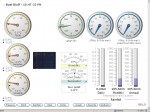
Around this time one of the lightkeepers on the Central BC Coast took it into his own hands and at his own expense to provide twenty-four hour up-to-date weather reporting through his own private weather station which was uploaded to the internet via satellite dish.
Mike Higgins at Boat Bluff was providing this service free of charge to all mariners on the Central Coast of British Columbia. A most valued service I heard, and also a controversial one as it was monitored by Department of Fisheries and Oceans (DFO) and Environment Canada (EC). Mike had a graphic readout online and a text readout also.
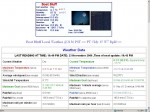
The text page contained the latest local weather report from his lightstation along with a condensed summary of the local conditions such as wind speed, pressure, rainfall and other pertinent details. This information was collected from a Davis Vantage Pro weather collection system complete with weather collection software.
Environment Canada has many automated sysems but none with the reliabilty of this one (a manned station). To put it into Mike’s words, “The system I was using consumed more power than a simple solar panel/battery
system will provide. It had multiple interfaced parts that would not run for more than a week or so without some form of human intervention (power generation, weather system, computer, satellite internet connection, webcam, and software).” So, a manned presence was required, but at what cost? The lightkeeper and power were already there.
Mike told me, “The biggest users were the small aircraft flying the coast – they absolutely loved it. I used a piece of software called Google Analytics to monitor who looked at my web pages and a large percentage of the traffic was small airlines and the Coast Guard helicopters.”
I asked Mike, “How did the boats access your weather data online? I know you had a website (URL) for them but did the boats have satellite internet connections or what? If so, I imagine it would not be useable when underway but only at anchor – true? So, your data is limited but useful. Only from a fixed (land) station would it be reliable? Just curious as people may ask.”
Mike replied, “Yup, it was virtually useless to vessels already at sea. The way vessels used it, is as you said, prior to departure. Vessels with home offices were looking at the weather and passed it on to the ships via cell phone or sat phone.”
“Cell [phone] on the Coast was really expanding at the time, very surprisingly. Bella Bella had Digital Cell available from about Walker Island through to Idol Point. Klemtu had Cell and it was available from just North of Jorkins Point through to Boat Bluff. They could pick up Cell again around Bonilla. It would not surprise me at all if Telus put in a Cell site at Hartley Bay as well. That would give all vessels transiting the Central Coast Cell every few hours after getting by Cape Calvert.
So, they get it near Port McNeil/Port Hardy, then Bella Bella, then Klemtu and maybe Hartley Bay and finally as they close in on Prince Rupert. Pretty big change from when you were at McInnes for sure.”
“The new Digital Cell phones can also download internet so my pages were available to them if they wanted it.”
What a great system that was and all paid for by a private citizen. Mike estimates his outlay at just over $2500.00 CDN and he paid about $60 CDN per month for the connection.
But it didn’t end there! Mike also provided internet access through a WiFi hotspot at Boat Bluff. He said: “I had a three watt booster and an antenna on the porch and if you had an external antenna you could get internet access a full mile away from Boat Bluff”.
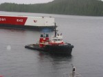
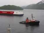
Mike sent me a couple of photos which show the Seaspan Corsair which was sitting just off the station. He said, “One of the pictures was taken just as he was leaving. The barge was drifting in towards the station and he had to run.”
Pretty nice service and all provided free of charge, and the government still wants to eliminate lighthouse keepers!
***************************************
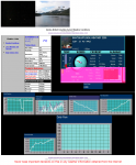
Back to present day (2012), Mike Higgins retired in 2006 but I see the keeper at Boat Bluff lighthouse has kept up the service and is using instead of the Davis instrument, an Ambient Weather system. This also displays a full internet weather page called the Virtual Weather Station.