Search and Rescue (SAR), Canada

Canadian SAR Regions

One of the responsibilities of Canadian lighthouse keepers is to assist and help in Search and Rescue (SAR). They are part of the Canadian Coast Guard (CCG) and can be called upon to assist in a search at any time, be it for missing people in boats, aircraft, or other forms of transportation.

In fact lighthouse keepers, because of their location, are ideally situated to assist in SAR activities. It is too bad that the CCG does not promote this side of lighthouse activities, and provide better training and equipment. Most of the SAR activities done by lightkeepers are done with their own equipment – be it boats, radios, scanners, survival suits, etc. More on this in another post.

SAR is a large community in Canada, but a branch of SAR that is not too well known by the public, except for those involved, is CASARA (Civil Air Search and Rescue Association).1  Continue reading Search and Rescue (SAR), Canada

5 Minute Management Course +

No matter where you work, we all like to make fun of management. It was no different on the lighthouses. In my day they went by mail, or word of mouth; now it is more rapid by email. You may have heard these before, but they are still funny.

5 Minute Management Course (for all those wishing to attain a higher position)  

Lesson 
1 :

A priest offered a Nun a lift.
She got in and crossed her legs, forcing her gown to reveal a leg.
The priest nearly had an accident.
After controlling the car, he stealthily slid his hand up her leg…..
The nun said, ‘Father, remember Psalm 129?’ Continue reading 5 Minute Management Course +

Website – Rough Radio – Wireless on the BC Coast

This is a promotion for my friend Frank Statham’s website Rough Radio – Wireless on the British Columbia Coast.

As I started off collecting lighthouse keeper names for genealogy records, Frank started with a collection of photographs, and with his past work as a radio operator, his interest was sparked into creating a website to help people remember the early days of radio on the BC coast. He also has been keeping a list of station personnel which you will find here.

The quotes below from Frank’s website show that lighthouses came first, but with the advent of radio, the two worked closely together, in fact sometimes so close together that they were on the same station – e.g. Estevan Point  or Pachena Point. 

“At the end of the 19th Century, the west coast of Canada was dangerous place for the movement of vessels.  There was little European settlement along the coast north of Victoria.  The only navigational aids for vessel traffic consisted of a scattering of lighthouses.”

“The 1907 Canadian Dominion Government, in an effort to provide some measure of safety for mariners, implemented a plan to provide a life saving trail along the Juan de Fuca Strait Vancouver Island, lifeboat stations, and wireless radio stations.  The first five wireless stations, Vancouver, Victoria, Pachena Point and Estevan Point were all operational by January 1908.”   Continue reading →

Some photo samples from Frank’s website below:

 [nggallery id=17]

Why We Need MORE Lighthouses in British Columbia

One of the arguments for destaffing the lighthouses in British Columbia (BC), Canada is that they are no longer needed because all vessels have the Global Positioning System (GPS). Canadian mariners must move into the 21st Century they say!

Have you ever looked at British Columbia? The size of British Columbia?

Note the three roads to Vancouver, Bella Bella, and Prince Rupert

British Columbia is the westernmost province of Canada, bordered by the Pacific Ocean. With an area of 944,735 square kilometers (364,764 sq mi) it is Canada’s third-largest province. The province itself is eleven times the size of Austria, where I live; nearly four times the size of Great Britain, two and one-half times larger than Japan and larger than every U.S. state except Alaska. 1 Continue reading Why We Need MORE Lighthouses in British Columbia

After I posted the story Building McInnes Island Ken Stewart sent me a letter with a leaflet detailing his adventures on McInnes, complete with drawings. Very interesting. See it near the bottom of the above article in PDF format complete with illustrations. – JC

The Remains of Cape St. James Lighthouse and Radio/Weather Station – filmed July 24, 2006

Cape St. James when manned

Automated on September 01, 1992, the videos below show all that remains of a lighthouse after automation, plus a nice view around the coastline. This was a thriving community of lighthouse keepers, radio operators, weather observers, and their families.

Note the complete lack of a lighthouse (originally with a 3rd order fresnel lens) and ancillary buildings. In the second and third videos note the automated equipment with solar panels and control building. No lighthouse, no people, no problem . . . until it quits, during a week-long storm, and helicopters cannot fly! 

Part 1

http://www.youtube.com/watch?v=_ua6rMh02l0 Continue reading The Remains of Cape St. James Lighthouse and Radio/Weather Station – filmed July 24, 2006

Lighthouse History – 24 (1906-01-20)

The following extracts taken from early Victoria, British Columbia (BC) newspapers are credited to Leona Taylor for her excellent work in indexing the papers. Full information can be found here: “Index of Historical Victoria Newspapers“, 2007-09.

************************************

Clayoquot, Jan 19 – When interviewed today, one of the crew of King David said: “We left Salinas Cruz, Mexico, in ballast on Oct 1 and went along fairly well until we got off the Vancouver Island coast, and then we struck a series of southerly and southwesterly hail and snow squalls. We finally drifted into Nootka on Dec 10, and in trying to beat out again struck Bajo Point. All the crew got ashore safely. The sailmaker, Donald McLeod, who is over 60 years of age, went insane when the vessel struck. After getting on the beach 2 men were despatched to find signs of habitation. Returning after 2 days search, they reported meeting a man, who informed them there would be no steamers up the coast till Mar 1. On hearing Continue reading Lighthouse History – 24 (1906-01-20)

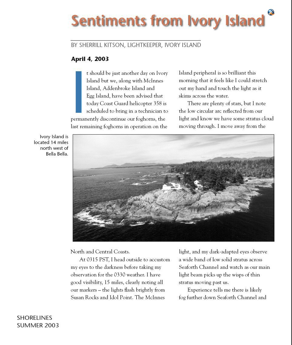
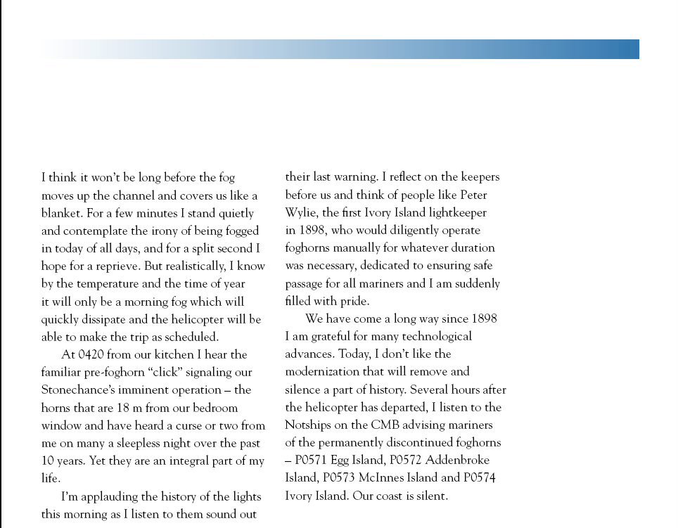
Removal of Foghorns on the BC Coast c. 2003

 The article below was written in 2003 by Sherrill Kitson, wife of the lightkeeper Rene Kitson, and herself a qualified lightkeeper at the time.

This story will illustrate why lightkeepers, and not electronic sensors, are better weather observers. We can smell the fog, and many a mariner will back us up on that statement.

Now, all we can do is smell the fog, and hope that nobody gets hurt because there are no more foghorns.

(The text below is in a picture. If it is too hard too read, hold down the CTRL key (STRG in Deutsch) and rotate the wheel on your mouse forward or back to increase the photo size – it works on most computers and operating systems.)


The story is reprinted here with permission of Fisheries and Oceans Canada from their publication Shorelines 2003 (which does not appear to be available online – if anyone knows a link, please let me know).

Our First Union Meeting – November 13, 1994

This post will not have much interest for the average reader, but then it might, because it shows how isolated we were on the West Coast lighthouses.

We, meaning lighthouse representatives representing all the BC lighthouses, got together for the first time in our lives for a Union Meeting. It was in Vancouver, BC, at the Century Plaza Hotel.

Not a big deal you might say, but it was! It was the first time some of us had seen each other in all our lives on the lights – it was November 13, 1994. I had been on the lights for 25 years and had never met the majority of keepers there. Continue reading Our First Union Meeting – November 13, 1994

Lighthouse Photos from Emails

As this website is about lighthouses, many people send me emails with photos and links. This past week I received three such emails so I will combine them all in one as they all contained photos of lighthouses. – JC

Email 1. Peggy’s Cove, Nova Scotia During Hurricane Irene (text from the email)

Hurricane Irene 2011

These pictures show the seas that came ashore after Hurricane Irene (August 20 – 29, 2011) went by.  Many of you have been to Peggy’s Cove, Nova Scotia, Canada. Well, the RCMP had the road shut down – only people who lived in the village could enter. The road was closed on both sides of the cove; waves were coming in over the road at about 10 meters, 30 feet for those that are not bi-measurement. The last hurricane that went by actually moved the restaurant at Peggy’s Cove a couple of feet.  These pictures were taken with a telephoto lens from the hill beside the cove. The pictures were taken by a friend of a neighbour (will the friend of the neighbour please come forward and introduce yourself – nice photos) – JC Continue reading Lighthouse Photos from Emails