Tag Archives: WX

Weather Observing – a Large Part of the Job

Note:- How to obtain an up-to-date weather report from a BC lighthouse
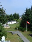
McInnes with weather instruments (lower half) – photo John Coldwell

One of the duties on most of the lighthouse stations, and especially on McInnes Island, up to 2003, was the reporting of local weather (weather visible in the immediate area of the station) to Environment Canada (EC) – earlier called the Atmospheric Environment Service (AES) – for re-broadcast to boaters, pilots and climatologists.

This became even more important after the Tropical Storm of October 1984 hit the British Columbia coastline.
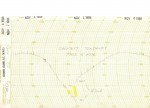
Extreme Tendency November 05, 1988 – scan Glenn Borgens

Every three hours during the day, starting at around three o’clock in the morning we would collect the information on sky condition, visibilty, wind speed and direction, rain/snowfall, wet and dry bulb temperatures plus maximum and minimum temperatures, station pressure and tendency (whether pressure was rising or falling and how rapidly), and sea and swell height. This was then recorded on AES forms or in a notebook depending on the station. Not all stations reported or had the instruments for all observations. These records were forwarded to AES every month along with a Climate Summary for the month. Continue reading Weather Observing – a Large Part of the Job

Weather Reporting at Boat Bluff c. 2004

The Lightkeeper – many years ago he had no contact with anyone – now the whole world can communicate with him and through him! 

Around 2004 the Canadian government decided to limit the weather report information put out by the lighthouse keepers to a very restricted set of criteria. 

Wind detecting devices (anemometers) were removed, pressure detecting devices (barometers) were removed and devices for measuring cloud height (ceilometers) were also removed. Basic weather training was kept to a minimum. The lightkeeper was left to his own devices to observe and report the weather every three hours to his designated Coast Guard radio station. 

No one was interested or affected . . . except those that used the weather reports! – the aircraft pilots, cruise ships, fishing boats, recreational boaters, and others that travelled the wind-swept and storm-lashed west coast of British Columbia. This coast is over 7,000 kilometres long from Vancouver, BC to Alaska, USA if you follow all its indentations, and sometimes these indentations are a life-saver when a storm blows up. (see the article Why We Need MORE Lighthouses . . .) Continue reading Weather Reporting at Boat Bluff c. 2004

COOLTAP

Environment Canada (EC) has a cooperative/volunteer climate network weather collection project called COOLTAP.(Cooperative Online Temperature and Precipitation Entry System). It is a web-based Data entry system website where daily weather data is entered and used. All that is required is an internet-connected computer to input the data.

NOAA (USA) uses a similar data collection program called COOP  Here is a PDF file on NOAA, COOP and the integration of COOLTAP. This data is used for both weather forecasting/climate prognosis and drought control.

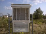
Weather box, aka Stevenson Screen, used to record temperatures

British Columbia lighthouse keepers, as employees in the Pacific and Yukon Region (PYR) of Environment Canada  also work in this program as well as performing their many other duties. Continue reading COOLTAP