Category Archives: Environment

Reprint – “Stand” – An Adventure Documentary


Stand – Power Teaser

 [media url=”http://vimeo.com/52119128″ width=”400″ height=”350″]

[private]https://ccanadaht3.com/wp-content/uploads/2012/11/Vimeo-.mp4[/private]

 from  PLUS


STAND, presented by Quiksilver Waterman, will take viewers on a journey through the waters of B.C.’s west coast. Through the stories of an aboriginal high school class building their own stand-up paddleboards as a form of protest, the efforts of expedition stand-up paddler Norm Hann, and the powerful surfing of iconic west coast native Raph Bruhwiler, the diversity of people, landscape and wildlife that would be affected by an oil spill
will be articulated. STAND will take you to the core of the issue and unfurl the soul of B.C.’s west coast one paddle stroke at a time.
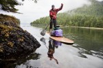
Cedar Standup Paddleboard

The crew is currently raising funds through the popular crowd-sourcing platform IndieGoGo, in order to complete post-production and bring this story into the mainstream consciousness. You can become a champion of the Great Bear and help protect our precious coastlines by donating to the project and in return receive some great rewards.

IndieGoGo Fundraiser: indiegogo.com/standfilm

Created by Anthony Bonello and Nicolas Teichrob

Music:
Original Score by Alan Poettcker (myspace.com/thesekidswearcrowns)

Sound Design:
Gregor Phillips (cinescopesound.com/)

Cinematography: Anthony Bonello and Nicolas Teichrob
Editing: Nicolas Teichrob

Additional footage courtesy of:
Adam DeWolfe (adamdewolfe.com)
Pacific Wild (pacificwild.org)
Peter Yonemori

***************************

STAND – a SUP adventure through the Great Bear Rainforest

 [media url=”http://vimeo.com/38708656″ width=”400″ height=”350″]

[private]https://ccanadaht3.com/wp-content/uploads/2012/11/stand_-_a_sup_adventure_through_the_great_bear_rainforest_1280x720.mp4[/private]

October 23, 2012 –  “STAND” the new film from b4apres Media in association with Dendrite Studios will take you into the heart of the largest temperate rainforest on the planet—the Great Bear in British Columbia, Canada. Hung on the skeleton of a good ol’ fashioned adventure undertaken by a group of surfers, the potential effects of introducing super tankers to these pristine waters will be articulated. As the crew moves through this remote region under their own power, the landscape will be unfurled one paddle stroke at a time and punctuated by the faces and fears of the First Nation people who call this garden of Eden their home. Not just an efficient mode of transport, a stand up paddleboard expedition will be symbolic of “standing up” to preserve this last bastion of rainforest. Captured in cinematic High Definition, the film will bring the Enbridge Pipeline debate into the collective consciousness in a way that will have you fishing in your basement for that old fluorescent wetsuit.

Quiksilver Waterman has signed on as the presenting sponsor for STAND. Since the crew had the concept for the film last year, they have been searching for a partner to support the project. That partner, however, needed to be the right fit and believe in the cause, in protecting British Columbia’s West Coast. Thankfully Quiksilver Waterman along with the Quiksilver Foundation 1 share a strong commitment to the environment.

Norm Hann and Raph Bruhwhiler are both Quiksilver ambassadors and agreed to join the project from the beginning. Both are true waterman and dedicated to the protection of the waters that they derive so much enjoyment from as well as the occasional seafood platter. Having Quiksilver Waterman involved makes the perfect trilogy and will allows the filmmakers to illuminate the stories, adventures and landscapes that abound in this truly magic part of the world.

Long protected by the 1972 Trudeau government moratorium on crude oil tankers plying British Columbia’s north coast, these waters are now facing the risk of oil spill. Potentially, 225 Very Large Crude Carriers (VLCC) per year would each transport approximately 2 million barrells of oil through the Great Bear Rainforest. In context, today’s supertankers carry ten times the volume of the Exxon Valdez oil spill. Put simply, the pristine marine and terrestrial ecosystems as well as the people of the Great Bear would likely not recover from such an incident.

This issue is perhaps the most important environmental issue in B.C. history. Whats more, a catastrophic oil spill could reach beyond borders and impact much of the Pacific North West coastline.

Visit the official Dogwood Initiative Website to learn more and find out how to get involved.

August 21, 2013Go see the film in Toronto.

****************************

FOOTNOTE:

1 For years, Quiksilver and Roxy have been actively engaged in charitable activities, both locally and globally. Quiksilver recognises the concept of corporate social responsibility and benevolence. We want our philanthropic work to have impact beyond what we do as one company and believe that we can do this by coordinating the support of other organizations and individuals. The Quiksilver Foundation was formed to bring all of Quiksilver’s charitable giving under one umbrella. The Foundation commenced its activities as a private foundation in October of 2004.

With offices in Europe, Australia and America, Quiksilver has the capability of reaching people worldwide. Quiksilver has the vision of making a difference to community and environment through the Quiksilver Foundation.

The Quiksilver Foundation is a non-profit organization committed to benefiting and enhancing the quality of life for communities of boardriders across the world by supporting environmental, educational, health and youth-related projects.
The Quiksilver Foundation has a commitment to improve the quality of all our lives.
We desire to benefit:

Local Communities, including schools, local charities through support and outreach programs;

Major special projects and organizations sharing our focus on children, education, science, oceans and the environment.
Reprint – New Tsunami Warning Protocol Rolled Out in B.C.

New tsunami warning protocol rolled out in B.C.

New system tested by magnitude 6.4 quake off Alaska coast on Monday

CBC News 

Posted: Nov 12, 2012 2:43 PM PT 

Last Updated: Nov 12, 2012 7:05 PM PT 

[media url=”https://ccanadaht3.com/wp-content/uploads/2012/11/bc-tsunami-warning-williams-11_32291146.flv” width=”400″ height=”350″]

The B.C. government is upgrading its tsunami warning plans following delays broadcasting emergency information after a magnitude 7.7 earthquake last month.

After the quake struck off the west coast of Haida Gwaii on Oct. 27 at 8:04 p.m. PT, emergency officials in B.C. did not issue any sort of tsunami alert or advisory for 51 minutes, leaving many civic leaders in B.C. wondering what they were supposed to do. . . . more

[private]

But many communities did start evacuations based on notifications issued by U.S. officials just minutes after the quake was detected.


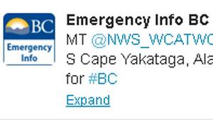
B.C. has rolled out a new system to issue tsunami alerts and advisories faster to the public using twitter, email and SMS. (Emergency Info B.C./Twitter)

After questions about B.C.’s response, Justice Minister Shirley Bond ordered a review of the notification protocol, and on Monday she rolled out the changes.

Under the new protocol, when emergency officials in B.C. receive an alert or advisory from the West Coast and Alaska Tsunami Warning Centre, they will immediately email it to a list of prioritized local authorities, emergency responders and media outlets.

The alert will also be immediately broadcast on Twitter thru the @EmergencyInfoBC account and posted on the Emergency Info B.C. website.

Provincial emergency officials will then follow up with direct phone calls to local authorities starting with those in areas of highest risk.

Alaska earthquake tests new protocol

The system appeared to be in operation when a magnitude 6.4 earthquake struck about 248 km off the coast of Alaska on Monday afternoon at 12:42 p.m. PT.

At 12:46 p.m., the @NWS_WCATWC twitter account broadcast a message saying there was no tsunami danger for the West Coast from Alaska to California.

A modified version of the tweet was retweeted on the Emergency Info B.C. account at 12:50 p.m.

Other improvements to the Emergency Info B.C. website will include:

  • A mobile version for use on smartphones.
  • An RSS feed for updates
  • Development of an interactive map for tsunami warning zones.
  • Digital audio recordings of tsunami warnings posted online.

Justice Minister Shirley Bond said the changes are the direct result of a review that was conducted following the Oct. 27 earthquake.

“We made a commitment to review our earthquake and tsunami response and we are now taking action to implement some of the early recommendations identified,” said Bond.

“We have also been in direct contact with those mayors who expressed concern about B.C.’s emergency response reaction time and have communicated with regional district board chairs, local authorities and first responders, gathering their feedback.”

How to sign up for tsunami warnings:


[/private]

Reprint – The Lighthouses of British Columbia


In February 2012 I wrote an article on the seawater sample collecting from the BC lighthouses here My story discussed the duties and .trials a lightkeeper had while obtaining the samples. This story details the use of the information collected from a scientist’s point of view.

********************************

The Lighthouses of British Columbia

by Allan Roberts

Not only are British Columbia’s lighthouses picturesque, and important for navigational purposes, but they also collect oceanographic data! You can access sea surface temperature (SST) and surface salinity data at the following website:

www.pac.dfo-mpo.gc.ca/science/oceans/data-donnees/lighthouses-phares/index-eng.htm

This website also has photographs of the lighthouses. (See below.)

Figure 1. Race Rocks (48.180 N, 123.320 W). Photo credit: Fisheries and Oceans Canada. Photograph obtained from: http://www.pac.dfo-mpo.gc.ca/science/oceans/data-donnees/lighthouses-phares/index-eng.htm

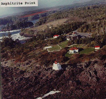
Figure 2. Amphitrite Point (48.550 N, 125.320 W). Photo credit: Fisheries and Oceans Canada. Photograph obtained from: www.pac.dfo-mpo.gc.ca/science/oceans/data-donnees/lighthouses-phares/index-eng.htm

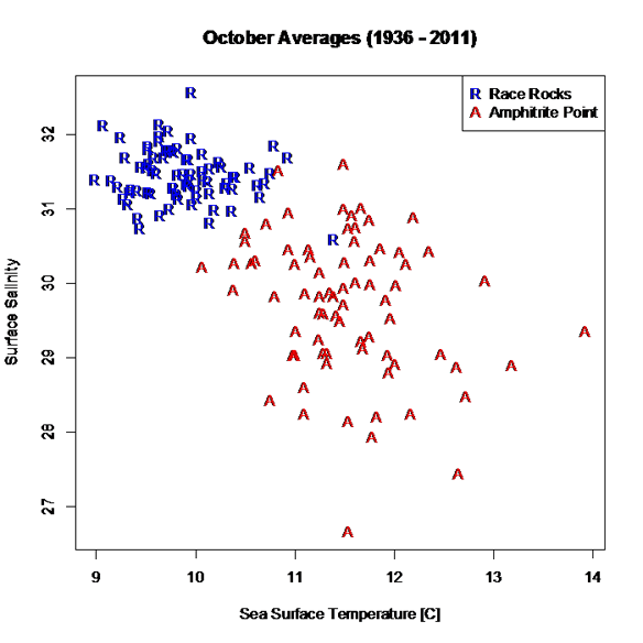
I’ve compiled and plotted some of the data from the Race Rocks and Amphitrite Point lighthouses. Race Rocks (Figure 1) is near Victoria, while Amphitrite Point (Figure 2), on the west coast of Vancouver Island, is closer to Bamfield. The data plotted in Figure 3 are monthly averages for October, covering the years 1936 to 2011. The plot shows an evident contrast in SST and surface salinity between the two sites.

Figure 3. October averages for surface salinity plotted versus October averages for sea surface temperature. The data are from two different lighthouses: Race Rocks (48.180 N, 123.320 W) and Amphitrite Point (48.550 N, 125.320 W). Race Rocks is near Victoria, while Amphitrite Point is on the west coast of Vancouver Island. Data are not plotted for 1940 and 2007, because of missing values. Graphics produced with R (R Core Team, 2012). Data source: Fisheries and Oceans Canada, www.pac.dfo-mpo.gc.ca/science/oceans/data-donnees/lighthouses-phares/index-eng.htm (accessed Oct. 9, 2012).

A peculiarity of the lighthouse data is that they are not collected at the same time every day, as explained on the lighthouse data website: “Sampling occurs at or near the daytime high tide” (Fisheries and Oceans Canada, 2012).

If you want data for ocean bottom temperature and salinity (as opposed to surface temperature and salinity), such data are available through NEPTUNE Canada, and through the VENUS network (NEPTUNE Canada, 2012; VENUS, 2012).

Citations

Fisheries and Oceans Canada. 2012. Website. Accessed Oct., 9, 2012:http://www.pac.dfo-mpo.gc.ca/science/oceans/data-donnees/lighthouses-phares/index-eng.htm

NEPTUNE Canada, 2012. Website: www.neptunecanada.com

R Core Team, 2012. R: A language and environment for statistical computing. R Foundation for Statistical Computing, Vienna, Austria.

VENUS network, 2012. Website: www.venus.uvic.ca

A Lighthouse at Night


One of the nicest things about night shift on McInnes Island lighthouse was observing the sky on a clear night. It was always the same, and always different.

The same stars were always there, but the moon waxed and waned, comets streaked across at intervals, sometimes an airplane’s navigation lights blinked in the south, or sometimes the Northern Lights flashed in the north. Below are some more shots.

[nggallery id=66]

One of the problems with seeing such sights in the city is the city lights, often called light pollution. The graphic below ill show you what is seen and not seen as light pollution decreases.

I must confess, that is what the night sky looks like at night from a lighthouse, but not having a photo from my experiences on McInnes lighthouse as my camera was too amateurish for such detail, I added the lighthouse silhouette to the photos from the gallery below. Are the photos below fantastic or not?

[nggallery id=67]


But, when looking at the full-sized photo at the top, turn off your lights and imagine what it was like. Sometimes we would take a foam mat and lay down on the helicopter pad and just watch the night sky. It was fascinating. For meteor showers and comets it was unbeatable. Continue reading A Lighthouse at Night

Oops! What Happened to the Water?

A few days ago I posted an article on the lightkeepers being the eyes and ears of the BC coast. While writing it an incident was brought to my mind of my early days in 1977 on McInnes Island. We arrived on McInnes in August 1977 so this had to have happened in Spring 1978.

Every year on the British Columbia coast the herring start their spawn in early spring. We, being curious lighthouse keepers are always interested in the goings on in the sea, from the arrival of the salmon to the arrival of winter storms. We always had our eyes out for something happening.

Well, one of the things we had been warned about was pollution. One morning I awoke and the ocean around the lighthouse as far away as Price Island, two kilometers away, was a milky white as though lime had been dumped in the ocean. Nowhere could I see blue sea except distantly in front of the lighthouse.

white water – photo Flickr by poecile05

I was astounded! What had happened? I had no idea. Last night everything was normal; today, total chaos!

I phoned Coast Guard Radio in Bull Harbour and reported this accident, not knowing what it was or how to describe it. The operator said he would pass it on to the Coast Guard. 

That was it? The ocean was polluted! I could not see a foot into the water! That was all they were going to do? Continue reading Oops! What Happened to the Water?

Lightkeepers are the Eyes and Ears of the Oceans

Isn’t this a pretty neat photo? But what is it you ask?

If you run Google Chrome as a web browser1 you could use the Search by Image extension to find other copies of the photo and then the website, and then what is shown in the photo. Here I have just presented a photo with no information (caption).

This photo was shown in Facebook at one time I think. Through the browser extension mentioned above I found the origin of the photo and an explanation. Continue reading Lightkeepers are the Eyes and Ears of the Oceans

Reprint – Our Ocean Backyard – Invasion from the Sea

As a lighthouse keeper, we watched every Winter and Spring for “Asian” debris to wash ashore around our lighthouse. Mainly we were interested in the glass fishing floats, but we came across hundreds of items every year, and this was in the years 1977 – 2001. Every piece of this debris was usually coated with goose-neck barnacles and other marine life which came from who knows where.

Now we are terrified of a few marine animals on a barge, or motorcycle coming ashore from the tsunami debris? Please read the article below and come to your own conclusion.

In my opinion, debris, with marine life, has been coming ashore around the world. How do you think isolated islands get populated?

***************************

Our Ocean Backyard by Gary Griggs – Article #111

INVASION FROM THE SEA

A 66-foot long concrete and steel floating dock washed onto the Oregon coast near Agate Beach in early June. The Japanese consulate in Portland confirmed that the dock was one of four used by commercial fishermen for unloading squid and other catch at the port of Misawa, that had been ripped away from the coast during the March 2011 tsunami. It took about 15 months for the floating structure to make the roughly 5000-mile trip across the north Pacific, traveling about 10 miles a day. 

Scientists from Oregon State University’s Hatfield Marine Science Center discovered that the dock contained an estimated 100 tons of encrusting organisms, or about 13 pounds per square foot. These included several species of barnacles, as well as mussels, starfish, urchins, anemones, worms, limpets, snails and algae – dozens of species. 

Although most of the individual species are unique to Asia, this smorgasbord of marine organisms is similar to what you might find on a wharf or piling along the coast of California.  Continue reading Reprint – Our Ocean Backyard – Invasion from the Sea

Government Contracts to Paint Lighthouses

The title is a tiny bit misleading. The government is not contracting to paint the lighthouse (is not doing the job themselves using government personnel as in the olden days) but is contracting out to private persons to do the work previously done by government workers.

An interesting article on the Peggys1 Cove lighthouse in Nova Scotia says:


Peggys Cove lighthouse crumbling
Province, feds negotiate while structure suffers


However, dealing with the problem is not as straightforward as sending someone the tab. Peggys Cove is owned by the federal government, which is currently getting out of the lighthouse business. The Nova Scotia government is in negotiations to take over the site, but no date has been set for completion of the talks.

So who is going to paint Peggys Cove, and many other abandoned lighthouses?

One of the commenter’s on the above site made the following reply:

Here’s the link for all those interested in bidding. Go create an account on Merx and bid away your $400.00 to paint it.

http://www.merx.com/English/nonmember.asp?WCE=Show&TAB=1&State=1&hcode=DSmmOnl5zU6FVjU16CWLSQ%3D%3D

Now that Merx site is very interesting. It shows Canadian Public Tenders for jobs the Canadian Government puts out for bids. I searched but could not finds anything lighthouse-related, but maybe you will have better luck. Let me know if you find anything.

There are some interesting jobs available, but one thing comes to mind. What has happened to the Public Works Department of the Canadian Government? They used to do all the painting and construction projects..Does Public Works no longer exist?

Aha! I found it! It is now called Public Works and Government Services Canada (PWGSC). They pay me my pension, but do they do anything else? Check out PWGSC website and see if you can find out.

Not much there about painting old lighthouses. Lots on procurement and disposal though. So I guess they just buy stuff and dispose of it when no longer needed. Is any reader working for PWGSC that can better fill us in on the workings of PWGSC?

So, unless the community is going to do the work and pay for the job itself, I guess Canadian lighthouse are headed for a dim future (pun intended).

FOOTNOTE:
1 Peggys Cove (2009 population: approx. 46), also known as Peggy’s Cove from 1961 to 1976, is a small rural community located on the eastern shore of St. Margarets Bay in Nova Scotia’s Halifax Regional Municipality.- Wikipedia

This is a real edible cake from Sweet Treats by Jen - http://sweetsbyjen.blogspot.com/

One year ago today I signed up with HostPapa, a Canadian website service provider, after having purchased my domain name, and learned how to use WordPress, lighthousememories.ca became known on the Internet. So today is the 1st anniversary of the website know as Lighthouse Memories.

Before that time, the site had been running for seven years as a self-hosted site on my son’s server in Canada. It was moderately successful, and I had many contacts, but with the help of HostPapa and Google things have boomed and we have the website as it is today.

Over the past year I have transferred over all the files from my old website, and reposted them on the new site. As well I have tried to keep up on things that lighthouse keepers feel responsible for – pollution, weather, oil spills, wildlife and fish protection, as well as manning the light. The Canadian lightkeeper keeps his eye on everything on the sea and in the sky while performing his job.

Since January 2012, the Canadian government under Prime Minister Steven Harper has been undermining the roles of the Coast Guard on all Canadian coasts, but especially on the British Columbia coast. Firing scientists and inspectors, reducing the number of staff manning MCTS centers and planning on closing SAR and MCTS stations, not to mention declaring most of the lighthouses surplus. Not much of a birthday present. 

I must say though, thanks for all the support, the nice comments and all the stories, documents and photos that have been submitted over the years.

Oh yes! Speaking of photos! Soon I will be starting photo pages for each of the BC lighthouses, and would love to see lots of submissions. I will post each station on a separate page and give credit to all who submit. Thanks.


For Sale – James Island, Sidney, British Columbia, Canada


January 19, 2013 – As of today’s date the property has not sold!

OK, it’s NOT a lighthouse, but it is a light, and it is on your own private island. Well, it could be yours if you have $75, 000, 000 to spare! We can always dream!

If you wanted you could build your own lighthouse in the middle, but why worry, it comes with a white (W) flashing (Fl) navigational light (see LL #227 above)1 off the NW point of the island. All yours with the purchase of the island.

Take a look at the photo below!

 That is James Island off Sidney, British Columbia, Canada, and it is being listed by Sotheby’s International Realty Canada for the above-mentioned price.  To quote the website:

Situated only a few miles off of Sidney, James Island is in close proximity to Victoria, British Columbia’s capital city, and is easily accessed by private plane or boat. A retreat like no other, James Island compares to only a handful of international properties. Improved with a magnificent 18-hole Jack Nicklaus Signature golf course, the island has been thoughtfully developed to seamlessly blend in with not only its surrounding environment, but also its history. A wide range of improvements complement the island including a masterpiece

owner’s residence of 5,000 square feet, 6 beautifully appointed guest cottages, private docks and airstrip, pool house, managers residence, a ‘western village’, and much more.

The place used to be a munitions factory for years, up until 1994, when it was sold for $19,000,000. In the end Canadian Industries Limited (CIL) used to make gunpowders and dynamite. I remember as a child seeing the signs on Vancouver Island that trespassing was forbidden. 

Sotheby's Website


More photos on Sotheby’s website

More on the story from the Times Colonist newspaper


FOOTNOTES: 

1DESCRIPTION OF COLUMNS (in List of Lights Notations)

Column 1 -Indicates light list number of each aid

Column 2 -Name of aid

Column 3 -Location

Column 4 -Characteristic of light

Column 5 -Focal height in metres above water

Column 6 -Nominal range

Column 7 -Description, height in metres

Column 8 -General remarks, fog signals and CHS No. of the largest scale paper chart of the area