Tag Archives: island

Machias Seal Island – An Ongoing Border Dispute Between the United States and Canada

I have mentioned Machias Seal Island before in my articles here, here, here, and here.

Well writer John Farrier published on Neatorama on Tuesday, April 22, 2014 a great article about how MAJOR/insignificant this dispute really is!

1398212464-0

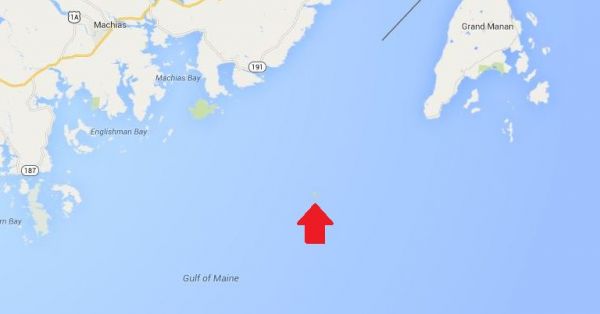
(Maps: Google Maps)

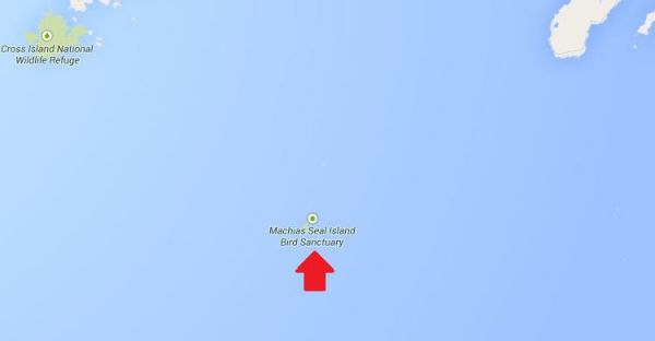
This is Machias Seal Island, a 20-acre island in the Bay of Fundy.

You can’t see it? Let’s zoom in.

And from there the story continues! Such an insignificant island for such a big debate. That is government for you. Naturally it belongs to Canada! . . . more

[private]

1398212464-1

Hmm. That doesn’t help much. Let’s zoom in some more.
1398212874-0

There it is! It’s a speck of land that barely appears on the map.

1398212874-1
(Photo: Albnd)

You can see the lighthouse in the photo above. The island is inhabited by 2 human lighthouse keepers, a few seals…

1398212874-2

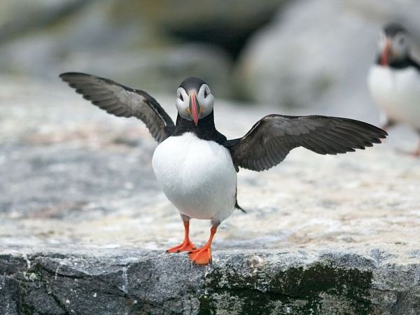
(Photo: Thomas O’Neil)

…and lots and lots of puffins.

The ownership of Machias Seal Island is disputed by the United States and Canada. Canada is in physical possession of it, but the United States has not formally dropped its claim to the island.

I’ve previously written several posts about the development of the US-Canadian border, whichincludes weird exclaves. Ambiguity about the border even led to the creation of 2 short-lived nations.

1398213788-0

(Painting by Benjamin West of the American delegation at the Treaty of Paris)

Although the United States and Canada now maintain a long, peaceful border, the placement of that border has been in doubt since the Treaty of Paris (1783) in which Britain recognized the United States as an independent nation. That treaty attempted to draw borders over unexplored lands. The authors did the best that they could with their knowledge of geography. But, alas, one of the descriptions for the border between Maine and maritime Canada was problematic. The treaty says that US territory includes:

all Islands within twenty Leagues of any Part of the Shores of the United States, and lying between Lines to be drawn due East from the Points where the aforesaid Boundaries between Nova Scotia on the one Part and East Florida on the other shall, respectively, touch the Bay of Fundy and the Atlantic Ocean, excepting such Islands as now are or heretofore have been within the limits of the said Province of Nova Scotia.

I’ve bolded the parts of the text that are the source for the Machias Seal Island dispute.

As I’ve mentioned in a previous post, the eastern border of Maine was of great concern to the British. Some British officials coveted what Americans saw as their territory, and vice versa. Control of the Bay of Fundy was of great importance to British commissioners at the Treaty of Ghent (1814), which ended the War of 1812.

1398215328-0

(Photo: Thomas O’Neil)

Now back to Machias Seal Island. The American argument is that it lies within 20 leagues (approximately 69 miles) of the coast of the United States.

The Canadian argument is that a land grant that pre-exists the Treaty of Paris defines the island as part of Nova Scotia. It built and has operated a lighthouse on the island since 1832.

Occasionally fishermen from the 2 nations have gotten into scraps about its ownership. Some Canadian citizens have staked mining claims to the island as a means of asserting Canadian sovereignty. The State of Maine has included the island on its maps of electoral districts.

But if possession is indeed 9/10ths of the law, then Machias Seal Island is Canadian. The United States has chosen not to press the issue.

Sources:
Clark, Edie. “Barna Norton Invades Canada.” Yankee 62.6 (1998): 48. Biography Reference Bank (H.W. Wilson). Web. 22 Apr. 2014.

Guo, Rongxing. Territorial Disputes and Resource Management: A Sourcebook. New York: Nova Science Publishers, 2007. Web. Google Books. 22 Apr. 2014.

Kelly, Stephen R. “Good Neighbors, Bad Border.” New York Times, Late Edition (East Coast) ed. Nov 27 2012. ProQuest. Web. 22 Apr. 2014 .

RELATED NEATORAMA POSTS

[/private]


For Sale – Piram Island, near Ghogha, India, with Lighthouse

Piram Island, India

I really do not know how these keep coming up, but here is a real island in the Gulf of Khambhat, India, and it is for sale! It tunrs out that it is an island full of fossil dinosaur eggs, giraffe and gigantic turtles. The owner Siddhrajsinh Raol has put the island up for sale at an undisclosed price.

June 17, 2012 – Times of India – Here is a news article on the sale with a bit more information.

Every point on this 90-acre island is riddled with fossils, some dating back 8,000 years. Fossils of two basic species of giraffes – Brahmatherium and Sivatherium – were found from the island in the 1860s. Those of the Hipparion have also been found here.

The lone lighthouse at the edge of the island only adds to its beauty. “Though the island is spread over 186 acres, the Directorate General of Lighthouse and Lightships owns the light house and its surroundings while the rest is mandatory government wasteland. I am the only private owner on the island. We have even offered the government that we could help them develop the wasteland,” says Raol.


Here is a description of the lighthouse from the Indian Directorate General of Lighthouses and Lightships:

And for the interested, here is the sales brochure. It is comically negative in its presentation, but also informative. When I was on McInnes Island lighthouse we had tides at times of twenty-two (22) feet (c, 7 meters). This gulf has tides of thirty-eight (38) feet – almost like the Bay of Funday in New Brunswick, Canada! Unbelievable!

Piram is located at 21º-35′ North and 72º-34’ East at a distance of 7.2 nautical miles south of Gogha and 4 nautical miles from the nearest part of main land. Asia’s biggest industrial belt stretching from Bharuch to Vapi is only 50 kilometres away. Diu and Daman, the famous tourist spots are only 80 nautical miles at a triangular distance, Pipavav, the major private port that is already functional is about 50 nautical miles and Mumbai, the main business centre of India is about 160 nautical miles Piram Island. – Introduction

The flow of water at the time of tide and ebb generates water current, which is the fastest in Asia, and in the world it is ranked at number two. It is like a river in spate, which reverses itself every six hours. Being part of the gulf system, the tides and ebbs at the coast of Piram are really remarkable, rising and falling by as much as 38 feet in just 6 hours which is the highest in Asia and second in the world. This is a mare natural feature in this region and makes it an exciting phenomenon. – Business Potential

Again I request, please let me know if you buy it!

For Sale – James Island, Sidney, British Columbia, Canada


January 19, 2013 – As of today’s date the property has not sold!

OK, it’s NOT a lighthouse, but it is a light, and it is on your own private island. Well, it could be yours if you have $75, 000, 000 to spare! We can always dream!

If you wanted you could build your own lighthouse in the middle, but why worry, it comes with a white (W) flashing (Fl) navigational light (see LL #227 above)1 off the NW point of the island. All yours with the purchase of the island.

Take a look at the photo below!

 That is James Island off Sidney, British Columbia, Canada, and it is being listed by Sotheby’s International Realty Canada for the above-mentioned price.  To quote the website:

Situated only a few miles off of Sidney, James Island is in close proximity to Victoria, British Columbia’s capital city, and is easily accessed by private plane or boat. A retreat like no other, James Island compares to only a handful of international properties. Improved with a magnificent 18-hole Jack Nicklaus Signature golf course, the island has been thoughtfully developed to seamlessly blend in with not only its surrounding environment, but also its history. A wide range of improvements complement the island including a masterpiece

owner’s residence of 5,000 square feet, 6 beautifully appointed guest cottages, private docks and airstrip, pool house, managers residence, a ‘western village’, and much more.

The place used to be a munitions factory for years, up until 1994, when it was sold for $19,000,000. In the end Canadian Industries Limited (CIL) used to make gunpowders and dynamite. I remember as a child seeing the signs on Vancouver Island that trespassing was forbidden. 

Sotheby's Website


More photos on Sotheby’s website

More on the story from the Times Colonist newspaper


FOOTNOTES: 

1DESCRIPTION OF COLUMNS (in List of Lights Notations)

Column 1 -Indicates light list number of each aid

Column 2 -Name of aid

Column 3 -Location

Column 4 -Characteristic of light

Column 5 -Focal height in metres above water

Column 6 -Nominal range

Column 7 -Description, height in metres

Column 8 -General remarks, fog signals and CHS No. of the largest scale paper chart of the area


Discovery Island Lighthouse Rots in the Sun

Automated in 1977, these videos show what happens to a sadly neglected automated lighthouse. What a place for a B&B! Thanks to Discovery Island website for the information. Just for your information discoveryisland.ca does not seem to be working anymore.

The two following videos I found on Youtube were originally posted by the website discoveryisland.ca

Take a look at the tower and lantern that the keepers so meticulously maintained. 

Originally the keepers at Discovery Island would manual record the wind speed and direction, air temperature, sea temperature, humidity, sea level pressure, wave height, ocean swell height and direction, visibility and sky condition and then report it back via radio about seven times a day. Now due to the automation of the lighthouse the weather reports have gone the same way.

The new weather Instrument are mounted on the top of the tower and measure the wind speed and temperature and then automaticly report it back to Environment Canada, when it is not broken.

Only twenty-seven MANNED lighthouses are remaining says the government!

In Memorium – Stanley Westhaver (1942 – 2005)

Stanley (Stan) Westhaver (January 30, 1942 – December 06, 2005) was a great person, a practical joker, the life of a party and a very good friend. As someone said, “He would give you the shirt off his back.” Stan died as he would have wished – at a party among friends. – John Coldwell (one of many friends who misses his bullshit every day.)

To include your memories in Stan’s memorial please click this link.

 Dscf0017