Category Archives: Transportation

Grocery Mishap at Kains Island (Quatsino) c.1975

CCGS Sir James Douglas

 The landing under the hook (aka highline) at Kains Island was a large basin at the back side. It looked like a very large boulder had been washed out from the hole. It was a bit tricky if the swell was running to bring the station inflatable in safely but we never had a accident in my three years on station. 


Ocean Sea foam - photo unknown photographer

After a SE winter storm the hole would fill up with kelp stems broken off the surrounding reefs by the large swells. The swells then pounded this kelp into a tan-coloured foam which drifted all over the ocean and blew up into the trees and hung there like lichen. It was quite light but sticky to the touch.

One winter day we were expecting the supply ship with groceries, mail, etc. One of the Coast Guard buoy tenders arrived rocking and rolling in the swells in Quatsino Sound. Over the side went the workboat and then began the process of off-loading the supplies into her. We could see the orange-suited crew members on deck and in the boat but could not recognize anyone. 

Lowering station boat into the hole - note the foam - photo retlkpr

As we watched the workboat pull away from the shelter of the ship we were called on the radio by an unknown voice that the boat was on its way in. We acknowledged and commented that this appeared to be a new mate. Always fun to see how much experience they had unloading under a highline. 

The boat rolled across the half kilometer distance between us and the ship, sometimes disappearing completely in the swells. The mate brought the boat closer to shore and lined up with the small bay, all the while ploughing a path through the foam which was pushed aside by the bow. As the boat neared the gap the mate rode a swell in under the hook and all but completely disappeared! 

We could see well from the winch shed and the highline deck but only heads were showing in the workboat – the rest had completely disappeared! During the night the storms had lashed the kelp to pulp and filled the gap with sea foam to almost a metre deep! The workboat rode in on the swell and right under the foam. 
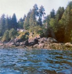
The gap from seaward at low tide - photo retlkpr

 Pushing the foam aside, the crew grabbed the lowered hook, slipped on a set of slings and signalled Haul Away. As the bonnet sling left the well of the workboat it also left a nice clean spot in the boat. On landing on the highline deck above, it was discovered that everything was covered with the sea foam, but, all was OK on the inside of the cartons of groceries and bags of mail although a bit sticky on the outside. The foam, although appearing quite dense, was actually quite dry and no harm was done. 

The mate was a little more cautious when he came in with the second load. 

************************************

 More information about the sea foam. Below is the content of an email I received in March 17, 2008.

HERE’S SOMETHING WE’LL NEVER SEE………WHIPPED OCEAN……..AMAZING!

Suddenly the shoreline north of Sydney was transformed into the Cappuccino Coast . Foam swallowed an entire beach and half the nearby buildings, including the local lifeguards’ centre, in a freak display of nature at Yamba in New South Wales .

One minute a group of teenage surfers were waiting to catch a wave, the next they were swallowed up in a giant bubble bath. The foam was so light that they could puff it out of their hands and watch it float away.

Boy in the bubble bath: Tom Woods, 12, emerges from the clouds of foam after deciding that surfing was not an option

It stretched for 30 miles out into the Pacific in a phenomenon not seen at the beach for more than three decades. Scientists explain that the foam is created by impurities in the ocean, such as salts, chemicals, dead plants, decomposed fish and excretions from seaweed. All are churned up together by powerful currents which cause the water to form bubbles. These bubbles stick to each other as they are carried below the surface by the current towards the shore. As a wave starts to form on the surface, the motion of the water causes the bubbles to swirl upwards and, massed together, they become foam.

The foam ‘surfs’ towards shore until the wave ‘crashes’, tossing the foam into the air.

Whitewash: The foam was so thick it came all the way up to the surf club

‘It’s the same effect you get when you whip up a milk shake in a blender,’ explains a marine expert. ‘The more powerful the swirl, the more foam you create on the surface and the lighter it becomes.’ In this case, storms off the New South Wales Coast and further north off Queensland had created a huge disturbance in the ocean, hitting a stretch of water where there was a particularly high amount of the substances which form into bubbles. As for 12-year-old beach goer Tom Woods, who has been surfing since he was two, riding a wave was out of the question ‘Me and my mates just spent the afternoon leaping about in that stuff,’ he said.

‘It was quite cool to touch and it was really weird. It was like clouds of air – you could hardly feel it.’

Children play among all the foam which was been whipped up by cyclonic conditions.

Of Ice and Men

Following along with yesterday’s story about travel on a CCGS ice breaker, and with the permission of the author, Pamela Coulston, I am reprinting her article here about life on Canadian Coast Guard ice breakers servicing the north and the lighthouses. I hope you enjoy it as much as I did.

****************************

Of Ice and Men

Surprisingly, everyone made it to dinner, they also made it to breakfast and lunch. The

Photo courtesy of Gerald Rohatensky

Coast Guard icebreaker Sir Wilfrid Laurier was taking a whipping from the weather in the middle of the Bering Sea. But not a meal was missed.

While the two cooks dished up three squares, the seas served up a storm that included winds gusting to 90 knots and 10-metre waves that broke over the bow, drenching the bridge four storeys above.

The captain ordered all loose items secured and all outer decks off-limits – any one of these larger waves could wash a person overboard to their death in near freezing waters. Continue reading Of Ice and Men

The Vanlene and I

I received the following email the other day promoting an article on a friend’s website: 

The freighter Vanlene ran up on the rocks on Austin Island in the Broken Group islands on March 14, 1972. She was carrying 300 Dodge Colt automobiles while enroute to Vancouver BC from Japan. The crew was rescued and taken to Port Alberni. How she ended up on the rocks is still a matter of conjecture but it appears that the Master simply did not know where he was at the time of impact (he thought he was off of the coast of Washington) and his navigational aids were inoperable. See the article at Nauticapedia


View Larger Map Continue reading The Vanlene and I

Supplies for Cape Scott Lighthouse 1975

CCGS Sir James Douglas - photo F&O Canada

 In 1975 we (myself, my wife Karen and our two young children, our dog, cats, and all our furnishings) were on our way clockwise around Vancouver Island from Quatsino lighthouse to Pachena Point on board the CCGS Sir James Douglas with acting Captain Tom Hull. This was a grocery run so the trip was already pre-planned and we were just passengers. 

The seas were not high but as we rounded Cape Scott, the northern-most tip of Vancouver Island, we began to roll in the southwest swell. As we motored around into quieter waters on the inside of Vancouver Island, we were still being tossed around by occasional large ocean swells.  Continue reading Supplies for Cape Scott Lighthouse 1975

Groceries at Green Island c.1975

Cloo-Stung - photo Barry Duggan

The Cloo-Stung was a catamaran of the Canadian Coast Guard (CCG) used for delivery of personnel and supplies to Prince Rupert area lighthouses in protected waters. The groceries were delivered to the Coast Guard base in Prince Rupert from the local stores. These were then packed in slings (large canvas or net circles with ropes attached to allow them to be attached to a hook) and loaded onto the Cloo-Stung. Continue reading Groceries at Green Island c.1975

Lighthouse Photos by Cyril R. Littlebury c. 1922-1932

Photos of British Columbia lighthouses by Cyril R. Littlebury in the years 1922 to 1932 with thanks to Dudley R. Booth for permission to publish – please visit Dudley’s new website at Historic Photos. There are many more photos there besides lighthouses.

When Dudley Booth developed some old negatives his father gave him he found a treasure trove of scenes from 1920s and 1930s Vancouver. 

[nggallery id=43]

  Continue reading Lighthouse Photos by Cyril R. Littlebury c. 1922-1932

Groceries and Mail on a Lighthouse

Groceries being loaded at Coast Guard Base - photo John Coldwell

Some of you may wonder why the number of stories about re-supplying the lighthouses exceeds the others on this site by a large margin (lots more coming!). Next to the family and job, the arrival of the mail and groceries was the most important event in the life of the lightkeeping family. 

Imagine no telephone, no television, no two-way radio, possibly no AM radio, and no contact with the outside world except what you saw going by your window. The post was and still is the most important contact to the real world.  Continue reading Groceries and Mail on a Lighthouse

Surviving on Fiddle Reef Lighthouse c. 1950s


View Larger Map

On January 21, 2012 I wrote about a family that lived on the lighthouses in the 1950s up to the 1960s, all in the days of no electricity – only kerosene lamps. I now have another installment from Ms. Juanita (Swanson) DuLong. She was only four years old at the time on Fiddle Reef, but memories are hard to erase – especially Lighthouse Memories!

List of Lights #215 - Fiddle Reef Sector

The map above shows the location of Fiddle Reef (1898 – 1978) just off Oak Bay, Victoria, BC. The lighthouse was on the rock under the green arrow. The lighthouse is long gone and is replaced with a white cylindrical tower with a white light and a red sector. Continue reading Surviving on Fiddle Reef Lighthouse c. 1950s

Discovery Island Lighthouse Rots in the Sun

Automated in 1977, these videos show what happens to a sadly neglected automated lighthouse. What a place for a B&B! Thanks to Discovery Island website for the information. Just for your information discoveryisland.ca does not seem to be working anymore.

The two following videos I found on Youtube were originally posted by the website discoveryisland.ca

Take a look at the tower and lantern that the keepers so meticulously maintained. 

Originally the keepers at Discovery Island would manual record the wind speed and direction, air temperature, sea temperature, humidity, sea level pressure, wave height, ocean swell height and direction, visibility and sky condition and then report it back via radio about seven times a day. Now due to the automation of the lighthouse the weather reports have gone the same way.

The new weather Instrument are mounted on the top of the tower and measure the wind speed and temperature and then automaticly report it back to Environment Canada, when it is not broken.

Only twenty-seven MANNED lighthouses are remaining says the government!

Day of Departure – Going on Leave c.1970s

MBB-105 - photo J. Coldwell

In the days before portable radios and instant communications, we were always apprehensive about the day we headed out for holidays. 

First there was the weather which as everone knows on the West Coast of Canada is always unpredictable even with modern weather forecasting. We observed the weather but rarely got any weather forecasts. 

Next came the Coast Guard. Our long-awaited flight could be diverted for search and rescue, maintenance, or any of a hundred other reasons.  Continue reading Day of Departure – Going on Leave c.1970s