Category Archives: USA

What Happens If You Break It?

Classic Fresnel Lighthouse Lenses   (Youtube)

artflo_15Another benefit of Facebook (FB), if you subscribe to the right channels, is the notification of new webpages. In this case a friend on Sentinelles des Mer (FB) led me to their webpage in Belgium www.sentinelles-des-mers.be again in French in case you clicked on the first link already.

What a beautiful sight (site?) to see! The page is covered with Fresnel lenses – originals and copies, plus they had links to the original webpage Artworks Florida which you will be happy to know is in English.

 Artworks Florida says:

Fresnel Lens Reproduction and Restoration​

Reproduction –
Artworks Florida custom designs and manufactures historic reproduction Fresnel lenses that were used to illuminate lighthouses in the 1800’s

Restoration –
Artworks Florida designs and manufactures custom lens components used in the restoration of original classic Fresnel lenses

Continue reading What Happens If You Break It?

Cruising the Inside Passage

Inside-Passage-Lighthouse-Photo-Credit-Chris-WheelerMany of the British Columbia lighthouses, manned and unmanned, are along BC’s world-famous Inside Passage.

Today I came across a new story on the Internet about this fabulous trip and it is onboard the new BC Ferries vessel vessel MV Northern Expedition (aka NorEx).

Northern Explorer
Image credit Mike – Voyager on West Coast ferries Forum

MV Northern Expedition

The article is called Cruising the Inside Passage from explore BC. Continue reading Cruising the Inside Passage

Machias Seal Island Photos

Machias Seal Island is located on the East coast of Canada between New Brunswick and Maine. It is best known for its bird populations – especially puffins – and also for its ongoing border dispute between Canada and the USA. Thi taken s morning I was notified of a lovely photo album taken this month at the island. It is quite a lovely place, but the light tower does need repainting, especially as it is symbolically representing Canada!

Machias Seal Island   August 2 2014


To navigate, click on a thumbnail photo and then when it opens, click on the arrows at upper right of page.

More photos of the light and island here on a Google Image Search. Historical information here in Wikipedia. Enjoy!

Machias Seal Island – An Ongoing Border Dispute Between the United States and Canada

I have mentioned Machias Seal Island before in my articles here, here, here, and here.

Well writer John Farrier published on Neatorama on Tuesday, April 22, 2014 a great article about how MAJOR/insignificant this dispute really is!

1398212464-0

(Maps: Google Maps)

This is Machias Seal Island, a 20-acre island in the Bay of Fundy.

You can’t see it? Let’s zoom in.

And from there the story continues! Such an insignificant island for such a big debate. That is government for you. Naturally it belongs to Canada! . . . more

[private]

1398212464-1

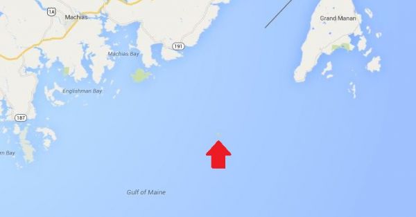
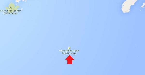
Hmm. That doesn’t help much. Let’s zoom in some more.
1398212874-0

There it is! It’s a speck of land that barely appears on the map.
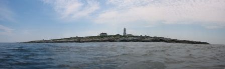
1398212874-1
(Photo: Albnd)

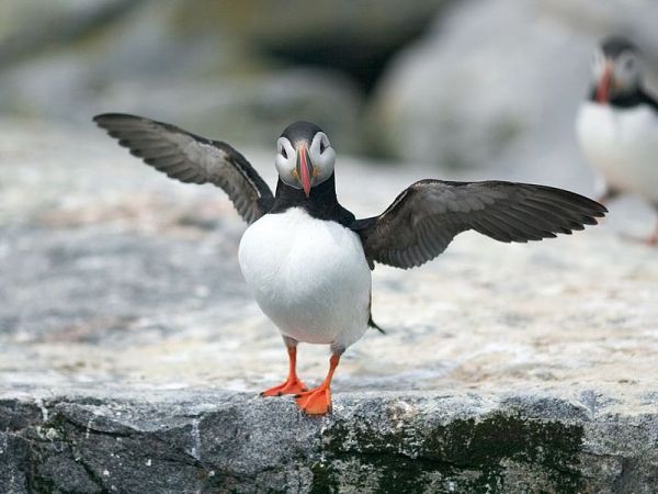
You can see the lighthouse in the photo above. The island is inhabited by 2 human lighthouse keepers, a few seals…

1398212874-2

(Photo: Thomas O’Neil)

…and lots and lots of puffins.

The ownership of Machias Seal Island is disputed by the United States and Canada. Canada is in physical possession of it, but the United States has not formally dropped its claim to the island.

I’ve previously written several posts about the development of the US-Canadian border, whichincludes weird exclaves. Ambiguity about the border even led to the creation of 2 short-lived nations.

1398213788-0

(Painting by Benjamin West of the American delegation at the Treaty of Paris)

Although the United States and Canada now maintain a long, peaceful border, the placement of that border has been in doubt since the Treaty of Paris (1783) in which Britain recognized the United States as an independent nation. That treaty attempted to draw borders over unexplored lands. The authors did the best that they could with their knowledge of geography. But, alas, one of the descriptions for the border between Maine and maritime Canada was problematic. The treaty says that US territory includes:

all Islands within twenty Leagues of any Part of the Shores of the United States, and lying between Lines to be drawn due East from the Points where the aforesaid Boundaries between Nova Scotia on the one Part and East Florida on the other shall, respectively, touch the Bay of Fundy and the Atlantic Ocean, excepting such Islands as now are or heretofore have been within the limits of the said Province of Nova Scotia.

I’ve bolded the parts of the text that are the source for the Machias Seal Island dispute.

As I’ve mentioned in a previous post, the eastern border of Maine was of great concern to the British. Some British officials coveted what Americans saw as their territory, and vice versa. Control of the Bay of Fundy was of great importance to British commissioners at the Treaty of Ghent (1814), which ended the War of 1812.

1398215328-0

(Photo: Thomas O’Neil)

Now back to Machias Seal Island. The American argument is that it lies within 20 leagues (approximately 69 miles) of the coast of the United States.

The Canadian argument is that a land grant that pre-exists the Treaty of Paris defines the island as part of Nova Scotia. It built and has operated a lighthouse on the island since 1832.

Occasionally fishermen from the 2 nations have gotten into scraps about its ownership. Some Canadian citizens have staked mining claims to the island as a means of asserting Canadian sovereignty. The State of Maine has included the island on its maps of electoral districts.

But if possession is indeed 9/10ths of the law, then Machias Seal Island is Canadian. The United States has chosen not to press the issue.

Sources:
Clark, Edie. “Barna Norton Invades Canada.” Yankee 62.6 (1998): 48. Biography Reference Bank (H.W. Wilson). Web. 22 Apr. 2014.

Guo, Rongxing. Territorial Disputes and Resource Management: A Sourcebook. New York: Nova Science Publishers, 2007. Web. Google Books. 22 Apr. 2014.

Kelly, Stephen R. “Good Neighbors, Bad Border.” New York Times, Late Edition (East Coast) ed. Nov 27 2012. ProQuest. Web. 22 Apr. 2014 .

RELATED NEATORAMA POSTS

[/private]


Mise Tales Thirty-Nine


For an update on what a Mise Tale is then please see Mise Tales One.

As mentioned earlier on the front page of my website, any photos or cartoons, or short information will also be included again later in the next Misc Tales when it is removed from the front page. That way you can keep track of it, search for it, or copy it.

*****************************

Enduring Lights – The Lighthouse Keeper is a historic documentary told through the accounts of four lighthouse keepers who tended America’s lighthouses in the 1900’s and never let the light go out. These men are living parts of history and their stories exemplify their significance in American history. – by Todd J. Burgess, photographer and video producer.

See his photo work in yesterday’s post Lighthouse in a Mason Jar.

*********************** Continue reading Mise Tales Thirty-Nine

Lighthouse in a Mason Jar

Bass Harbor Head Light   Todd Burgess2

Bass Harbor Head Light – Adding to the mind-blowing natural landscape of Mount Desert Island is the Bass Harbor Light. It was built 1858 for $5000 and is located located at the tip of Northeast Harbor. This morning shot also captured a full moon to the left.

The first time I saw this I was amazed! I had never seen lighthouses, or for that matter, anything framed like this. It is unique, interesting, and a framed print on your wall would have all your friends asking “Where did you get it?” Well, I can answer that question.

Maine in a Mason   Images   Todd BurgessThe prints, and many more lighthouses and unusual scenes in a Mason bottle are available from Todd J. Burgess on his website. Not only are the lighthouses identified but there is a small bit of information included as well – see under the above photo.

[nggallery id=91]

The above photos are all found in his gallery Maine in a Mason Jar (108 images)

Other images, including more lighthouses, can be found in Land and Sea (89 images) and History Preserved (6 images).


Book – Lighthouses of North America – Beacons from Coast to Coast

Lighthouses of North America – Beacons from Coast to Coast

The majority of lighthouses shown in this book are American, but as a friend of mine wrote:

I received a lighthouse book for Christmas – from an ex -lighthouse keeper and I groaned when I opened the parcel. “Oh yes, forty photos of Portland bloody Head I suppose.”  No, well yes, a couple, but Canadian lights and British Columbia lights –  4 pages on West Vancouver’s Pt. Atkinson, plus photo of Cape Mudge, and for comic relief Brockton Point (Stanley Park). – thanks JDR

So, not all bad news. The book is not coffee table format so it will fit easily on your bookshelf.

9781770852495Lighthouses of North America – Beacons from Coast to Coast

by Sylke Jackson and published by Firefly Books

320 pages, 8 1/2″ X 11″ X 1″
300 color photos, resources, index
EAN: 9781770852495
ISBN: [ 1770852492 ]
plastic-laminated hardcover
$35.00 CDN / $35.00 US Continue reading Book – Lighthouses of North America – Beacons from Coast to Coast

Mise Tales Twenty-Nine


For an update on what a Mise Tale is then please see Mise Tales One.

A beautiful view of the Nazare lighthouse at Praia do Norte outside the Portuguese fishing village of Nazare, Portugal. It is back dropped by what may be the world’s highest surfing wave.Article and photos on the National Post Sports page.

Nazare Lighthouse at Praia do Norte outside the Portuguese fishing village of Nazare

 *************************** Continue reading Mise Tales Twenty-Nine

Who Says Lighthouses Are Old Fashioned?

Boston_and_Graves_Lights


Can you imagine a lighthouse being used as an aeronautical beacon? Well there is one. It is in the United States at Boston’s Logan Airport and it uses the Boston Lighthouse as a visual marker for Visual Flight Rule (VFR) landings. See the copy of the aeronautical chart below:

Boston Logan Airport aeronautical chart
Boston Logan Airport aeronautical chart (not for navigation)

Continue reading Who Says Lighthouses Are Old Fashioned?

Mise Tales Twenty-Five


For an update on what a Mise Tale is then please see Mise Tales One.

Charm_BraceletEdgartown Lighthouse Charm Bangle

The first colony on Martha’s Vineyard, Edgartown is known primarily for its preserved 19th century seaport, picturesque harbor, and whaling traditions. Depicted on an Expandable Wire Bangle, the Edgartown Lighthouse is a beacon of light for generations of sailors and a popular point of interest for all seasonal guests. 

divider_faedust

 Can You Believe This?

During those times [late 1870s] lighthouse keepers were never supposed to leave the property unattended day or night, summer or winter, and the Dodges faithfully abided by that regulation for all of the years they were there which ended up being 51 years. More . .  Continue reading Mise Tales Twenty-Five