Tag Archives: storms

Reprint – Sentinels Encased in Ice

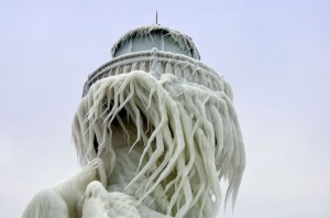
Sentinels Encased in Ice by Elinor DeWire

from WeatherWise November-December 2011 

Image10


The ice was here, the ice was there
The ice was all around;
I t cracked and growled, and roared and howled
Like noise in a swound…
—Samuel Taylor Coleridge
The Rime of the Ancient Mariner

Image7

Caption: St. Joseph Pierhead in Michigan as it appeared on December 20, 2010. Continue reading Reprint – Sentinels Encased in Ice

By-the-Wind-Sailor

VelelleOne of the things a lightkeeper notices on the shoreline are the different changes, be they strange fishing floats, bloated dead fish, defeathered seabirds, massed clumps of seaweed or the profligate carcasses of the By-the-wind-sailor.

 I had seen many beaches littered with the pale blue bodies of the By-the-wind-sailor and thinking they were the nefarious Portuguese Man o’ War I hesitated to examine them, fearful of the imagined sting I would receive. It was not until I read the article yesterday on the By-the-wind-sailor from the Monterey Bay Aquarium that I realized that I was in error in my knowledge. Continue reading By-the-Wind-Sailor

The Lighthouse of Maracaibo


What is the Lighthouse of Maracaibo? Where is it?

Well, first of all it is not a lighthouse, so if you are not interested please continue on to another article, but I think you will find this fascinating.


View Larger Map

Why is then called a lighthouse? Well, it can be seen from many miles away for over 160 nights a year over Lake Maracaibo in Venezuela. I would never have known about it except that my article antennae are tuned to anything lighthouse. When I heard about it, I just had to investigate and bring it to your attention. This is quite unique and the only place in the world that has this phenomena in such intensity.

It is said to have the hottest flash density rate in the world, with an annual average of 181 lightning flashes per square kilometre.During peak months there can be as many as fifty (50) discharges every minute. That is a nearly continuous thunderstorm with up to 20,000 flashes of lightning per night. That is a lot of lightning – the most persistent thunderstorm of the world!

From Wikipedia:

The storms (and associated lightning) are likely the result of the winds blowing across the Maracaibo Lake and surrounding swampy plains. These air masses inevitably meet the high mountain ridges of the Andes, the Perijá Mountains (3,750m), and Mérida’s Cordillera, enclosing the plain from three sides. The heat and moisture collected across the plains creates electrical charges and, as the air masses are destabilized at the mountain ridges, result in almost continual thunderstorm activity.

The phenomenon is characterized by almost continuous lightning, mostly within the clouds, which is produced in a large vertical development of clouds that form large electric arcs between 2 and 10 km in height (or more). The lightning tends to start approximately one hour after dusk.

Among the major modern studies there is the one done by Melchor Centeno, who attributes the origin of the thunderstorms to closed wind circulation in the region.

[media url=”http://www.youtube.com/watch?v=zRvpM01VTFU” width=”400″ height=”350″]
Preparing for a Winter Storm

This is what we heard on the radio from the Coast Guard station:

Marine forecasts issued by the Pacific Weather Centre of Environment Canada at 4 AM PDT Saturday 9 September for the period ending 4 AM Sunday with an outlook for the following 24 hours. The next scheduled forecast will be issued at 10:30 AM PDT.

Synopsis
A trough of low pressure over Queen Charlotte Sound will slide Over Vancouver Island later today. A cold front just west of Bowie will approach the Charlottes this afternoon. Over northern and central waters strong winds near the trough will rise to strong to gale force southeasterlies as the front approaches. Over southern waters light to moderate northwest winds will shift to moderate to heavy southeast later today as the trough moves to the south. As the front approaches from the west forecast sea state values are combined wind wave and swell height.

Central coast from McInnes Island to Pine Island.
Storm warning issued. Winds southeast 30 to 40 knots this morning then rising to southeasterly 40 to 50 this afternoon. Winds rising to south 50 to 60 this evening then to southeast storm force winds overnight. Overcast. Heavy rain. Seas 1 to 2 metres building to 2 to 3 tonight. Outlook. Winds continuing southeast storm force winds. Continue reading Preparing for a Winter Storm

The Storm of October 1984

The article I posted earlier about the storm at Cape Scott brought to mind a story I had written for the old website. This story (below) brought to the attention of the government one of the important attributes of BC lighthouse keepers – they are on-site!

*************************

Helicopter pad at McInnes

On Thursday October 12, 1984 Roger Mogg (my assistant) and I were up at the helicopter pad at McInnes Island  lighthouse enjoying the clear Fall weather after lunch. We had been shooting clay pigeons with our shotguns and a newly acquired launcher. The wind was light, with very few clouds in the sky, so it made a perfect day for target practice in between weather reports. 

Just then Karen called up that Stan at Egg Island  had just notified the Coast Guard radio station in Bull Harbour  that he had unexpected high winds and seas. Roger and I looked at each other and joked that Stan must have been into his home-made wine again! Looking down towards Calvert Island  (between us and Egg Island) from our location on the helo (helicopter) pad we could see only clear sky with a trace of cirrus cloud. Calvert was over forty miles (64 kms) away and we could just see the top of it on the horizon. Egg Island was further south still.  Continue reading The Storm of October 1984