The following extracts taken from early Victoria, British Columbia (BC) newspapers are credited to Leona Taylor for her excellent work in indexing the papers. Full information can be found here: ”Index of Historical Victoria Newspapers“, 2007-09.
Please Note: December 20, 2012 – I am continuing this series with Lighthouse History #51 because the newspapers have now been indexed up to 1932. I quit posting at #50 as the extracts only went to 1926. They have now been extended from 1927 to 1932 so I will sift through the data for anything lighhouse!
Died Dec 11, 1927 at V, Frederic Argyle, 52, born Dec 25, 1871 at Rocky Point lighthouse, where his father, who came here in the Royal Engineers, under Colonel Moody, was lightkeeper for many years, son of Thomas Argyle of Englandl and, and Ellen Tufts, of Halifax, NS. Leaves widow, Mrs E R. Pallbearers: G Ball, H C Helgesen, T F Helgesen, T Foster, Herbert Parker, W Welty. Metchosin burial. [Colonist, 1927-12-13*]
Died Apr 17, 1928 at Victoria, BC, Ellen Josephine Forsyth, 53, wife of James T, lighthousekeeper at Race Rocks. Born in NS, resident of BC 48 years. Leaves husband, daughter, 2 sisters, 2 brothers [Guthro]. Pallbearers: N Bertucci, W H P Trowsdale, W Muir, A E Whittaker, Captain G Evans, J Talbot. [Colonist, 1928-04-19*]
Died Jul 4, 1928 at Saturna Island, BC, James Georgeson, 79, leaves widow, Joan, 4 daughters, 3 sons. Born Oct 20, 1849, he came to Canada from the Shetland Islands in 1887, and was keeper of the East Point lighthouse for 32 years. He was granted the Imperial long service medal. Mayne Island burial. [Colonist, 1928-07-28*]
Rosina, 52 [47], wife of the Daniel O’Brien, Entrance Island lighthousekeeper, drowned today in Entrance Island. She was with her husband in a rowboat, and, on attempting to make a landing, the boat upset, throwing both into the water. O’Brien reached shore safely and ran to the McConvey ranch for help. McConvey, Bennett and Griffith returned with him to the scene and took Mrs O’Brien from the water. Formerly of Victoria, born in County Down, Ireland. Also leaves son, and a sister. Pallbearers: E Burkmar, W Mills, A Morgan, G Morgan, W Fisher, R Trowsdale. [Colonist, 1928-10-13, p. 15]
Mar 29, 8 – Tofino lifeboat brought Mr Halkett from Ucluelet to inspect the lifesaving station and Lennard Island lighthouse… [Colonist, 1929-03-19*]
Died Apr 3, 1929 at Victoria, BC, Henry Herbert Smithman, 39, born in North Carolina, he leaves widow, 4 children, mother, brother, 6 sisters. He served overseas in the Great War with PLI and was lighthousekeeper at Sister’s Rock Light. New Westminster burial. [Colonist, 1929-04-04*]
T Guerney to relieve D McPhee at Lennard Island lighthouse for 3 weeks. Owing to the Tofino customs office being closed, Fred Towler, postmaster, has been appointed to take over minor customs duties. [Colonist, 1929-05-19, p. 8]
As I stated in my post The Lighthouse as a Sovereignty Symbol, put a lighthouse on your disputed territory and it is yours, or something to that effect. Now here is another ongoing dispute coming to light again – Canada vs USA. According to my theory above, Canada wins! – retlkpr
Posted: Dec 23, 2012 7:37 PM AT Last Updated: Dec 24, 2012 12:38 PM AT
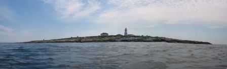
The Canadian flag flutters in the breeze by the lighthouse at Machias Seal Island. (Photograph by: Fred J. Field-The Canadian Press)
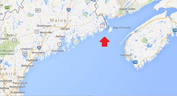
A tiny island between New Brunswick and Maine is the subject of renewed calls from both sides of the border to settle a territorial dispute once and for all.
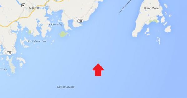
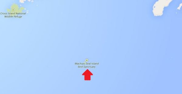
Machias Seal Island is a flat, treeless piece of rock located about 19 kilometres southwest of Grand Manan Island and east of Maine at the mouth of the Bay of Fundy.
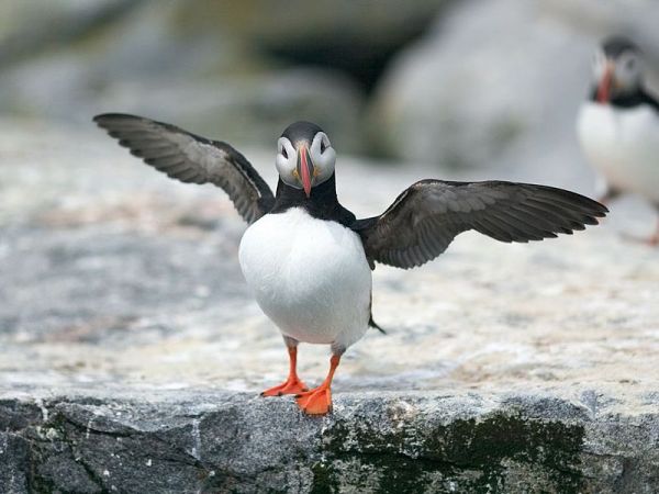
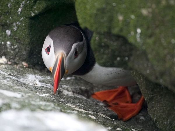
The island is a sanctuary for many kinds of seabirds including the Atlantic Puffin and draws visitors from around the world to observe them in the summer. more . . .
[private]
There are no permanent human residents on the island, just pairs of lightkeepers who spend 28 days at a time maintaining a lighthouse operated by the Canadian Coast Guard.
The original lighthouse was built by the British in 1832, and a lighthouse has been maintained there ever since.
So why would anyone even care which country gets title to Machias Seal Island?
‘Wouldn’t we feel silly?’ The answer lies in the 720 square kilometres of water around the island in what’s called a grey zone. Lobster fishermen from both Canada and the U.S. fish these waters.
“The fishing community on Grand Manan is permitted to fish there on an open-end basis and it’s our way of laying our claim to this water that is part of the Machias Seal Island dispute,” said MP John Williamson, who represents the riding of New Brunswick-Southwest.
Williamson said the island is considered to be in his riding.
‘I think our claim is sound and is legitimate.’ —MPJohn Williamson “I think our claim is sound and is legitimate, but at the end of the day it’s going to come down to the minister in this country and the administration in Washington to settle it,” he said. “I think it is in the interests of both of our countries to do that.”
That feeling is echoed by Stephen Kelly, a professor at the Center for Canadian Studies at Duke University and a retired American diplomat who has served in Canada.
“It just strikes me if we have this opportunity to remove a potential irritant going forward, why don’t we take it?” Kelly said in an interview from his office in Durham, N.C.
Kelly put his thoughts in a commentary for The New York Times last month, which he said he was prompted to write after seeing territorial disputes that have erupted between Japan and China over uninhabited islands in the East China Sea.
He said while the situation between Canada and the United States is much different, land disputes are better settled.
“What if some valuable resource is discovered in the grey zone around Machias Seal Island? What if some other contingency that we can’t imagine now of strategic importance comes along?” he asked.
“Wouldn’t we feel silly that we didn’t take the opportunity to resolve this when the stakes were relatively low.”
Irrelevant for lightkeeper
For Ralph Eldridge, a Canadian who has been a lightkeeper on the island for the last 16 years, the question of who owns Machias Seal Island is a “non-issue,” something that is never a question from the visitors who travel to the island each summer.
And Eldridge said he doesn’t have to produce his passport to go there.
“But neither does someone from the United States or China or Japan or Spain have to when they come to the island,” he said.
A spokeswoman for the Department of Foreign Affairs and International Trade said ownership of the island and surrounding waters is clear as far as Canada is concerned: they are Canadian.
“Canada’s sovereignty over Machias Seal Island and sovereign jurisdiction over the 210 square nautical mile surrounding waters is strongly founded in international law,” Barbara Harvey said in a statement.
[/private]
***********************************
[private]
In the Media Op-Ed: Canada and US dispute ownership of small rocky island Digital Journal By Ken Hanly Dec 25, 2012 in World
Tourist comes to Machias Seal Island during the summer to see birds such as the Atlantic Puffin.
Machias Seal Island is a tiny rock island 16 kilometres from the coast of the US state of Maine and 19 kilometers south of Grand Manan Island just off the coast of the Canadian province of New Brunswick. The island is claimed by both Canada and the US.
Machias Seal Island has an area of just 8 hectares or about 20 acres. The island is a sanctuary for many seabirds including the Atlantic Puffin seen in the appended video. Visitors from around the world come to view the birds during the summer. There are no permanent residents of the island although there are lighthouse keepers who come in pairs and stay four weeks at a time. The lighthouse is operated by the Canadian Coast Guard. The original lighthouse was built by the British in 1832. There has been a lighthouse maintained ever since. Many think that the presence of the lighthouse will give Canada a legitimate claim to the island. The United States has never had a presence on the island except in 1918 during the First World War when a small detachment of marines was posted to the island with Canadian agreement.
However in the past private citizens in Maine have claimed ownership of the island. There is a tour boat operator from Cutler Maine, who brings tourists to the island in the summer to view the birds. While there has been no oil or mineral resources discovered in the area, there is a large 720 square kilometres around the island called a grey zone. Lobster fishermen from both Canada and the US fish this area.
MP for New Brunswick Southwest , John Williamson said: “The fishing community on Grand Manan is permitted to fish there on an open-end basis and it’s our way of laying our claim to this water that is part of the Machias Seal Island dispute.I think our claim is sound and is legitimate, but at the end of the day it’s going to come down to the minister in this country and the administration in Washington to settle it. I think it is in the interests of both of our countries to do that.”
Unfortunately an earlier decision of a joint commission in 1817 did not decide the ownership of Machias Sea Island even though it did decide that of other islands in the area including Moose, Dudley, and Fredericks Islands that are now owned by the US and also Grand Manan island that now belongs to Canada.
Stephen Kelly of Duke University and a retired US diplomat thinks that it would be a good idea to resolve the issue.
“It just strikes me if we have this opportunity to remove a potential irritant going forward, why don’t we take it. What if some valuable resource is discovered in the grey zone around Machias Seal Island? What if some other contingency that we can’t imagine now of strategic importance comes along?Wouldn’t we feel silly that we didn’t take the opportunity to resolve this when the stakes were relatively low.”
Ralph Edlridge, who has been a light-keeper on the island for 16 years, thought ownership was a non-issue. Neither he nor anyone else who comes to visit the island has to worry about showing a passport whether they come from Maine, Canada, China, or Spain he said. Barbara Harvey a spokesperson for Foreign Affairs and International Trade said that as far as Canada is concerned the island is Canadian: “Canada’s sovereignty over Machias Seal Island and sovereign jurisdiction over the 210 square nautical mile surrounding waters is strongly founded in international law.” Some residents of Maine may not agree.
This opinion article was written by an independent writer. The opinions and views expressed herein are those of the author and are not necessarily intended to reflect those of DigitalJournal.com
Along the border of the Canadian province of New Brunswick and the American state of Maine sits a small rocky island caught between the two countries.
An almost endless number of headlines have been made in recent months over the (at times heated) conflict between Japan and China over the ownership of a small group of islands in the East China Sea.
Due to the nature of islands, often found along inexact maritime boundaries, ownership disputes are not uncommon – but few of them tend to make headlines. A recent article has shone a spotlight on one of these lesser-known tales, involving a lighthouse isle along the Canada/USA border.
Found at the mouth of the Bay of Fundy, Machias Seal Island is an unassuming rocky outcropping of less than 20 acres, with only a lighthouse tower and outbuildings raised above its flat, barren surface. This modest appearance may be why the island was overlooked during the latter part of the 18th century, when Britain and the newly-formed United States were defining their territorial boundaries. Surprisingly, the intervening centuries have done little to resolve the question of just who owns the island.
While the dispute over Machias Seal Island has remained a friendly one, it has heated up in recent decades. Unlike in the case of Japan and China’s battle over the Diaoyu/Senkaku archipelago, there are no rich offshore oil and gas reserves at stake, however, there is a vibrant lobster fishing industry in the indeterminate “grey zone” of the surrounding waters.
Image of island’s lighthouse from www.ccg.gc.ca
“It’s very congested,” said the head of local fisherman’s association. “It’s a very hard area to fish. The Americans think it’s theirs; the Canadians think it’s theirs, and nobody gets along all that well.”
Canada has, thus far, maintained the upper hand in the conflict – despite an elimination of full-time staff from lighthouses on the East Coast to cut costs, the building on Machias Seal Island bears the distinction of being the sole remaining non-automatic lighthouse in the region, a contiguous occupation that stretches back two centuries.
The Department of Foreign Affairs has been willing to foot the Coast Guard’s bill for the live-in staff, giving only the explanation that it is for “sovereignty purposes”.
The Chinese are at it. The Japanese are at it. The Brits and the Argentines are at it – all squabbling over small islands. There is even speculation that the US and Canada will revive their long-running dispute over little Machias Seal Island.
When large states are feeling small, it seems, small islands loom large. This is true not just of tiny, uninhabited outcrops. Independent and semi-independent islands are in the limelight too.
One reason for this is clear. Entitled to many of the same rights as large states, but without the same responsibilities, these islands pose an outrageous challenge to the international order and need to be brought back under control.
It is not just their tax practices, although this is the issue that currently defines the EU’s agenda. By selling passports to anyone passing, islands help criminals change identities and travel the globe undetected. And by conferring diplomatic recognition upon renegade countries, islands endanger global security.
There is a second reason too: entitled to many of the same rights as larger states, but without the same responsibilities, small islands are an outrageous challenge to the international order, and are therefore extremely useful allies to big countries.
Thanks to the competition caused by their tax regimes, small islands can be helpful to large countries wishing to impose fiscal discipline upon their partners or just hoping to excuse their own tax practices. And by handing out passports to all-comers, islands can ‘liberate’ the business elites and political opposition of repressive regimes – saving big states the need to intervene.
Small islands are even credited with a diplomatic daring which larger countries cannot afford to practice. Fearful of encouraging secessionist tendencies at home or of antagonising their international partners, large states are often too nervous to recognise breakaway countries. Small islands go where large states fear to tread.
This ambiguous status in an international system made for big players gives islands a significance quite disproportionate to their size. Take for instance Nauru (population: 9,000; size: 21 square kilometres; distinguishing features: looks from above suspiciously like a treasure island).
For years, China and Taiwan were locked in competition for Nauru’s diplomatic loyalty, with Nauru reportedly allowing itself to be bought first by one side then the other. Indeed, in 2002, when the Taiwanese president rocked the world by supporting a referendum on independence, his move was viewed as a reaction to Nauru’s sudden switch of loyalties to the People’s Republic.
The case of Nauru also shows how quickly islands can go from international pariahs to valued partners, depending on large states’ whims. In 2003, the US appears to have decided that the Nauruans’ passport-for-sale scheme was not a danger to international security after all. Just the opposite in fact: it offered a means to smuggle nuclear scientists out of North Korea. If reports are true, Nauru, the one-time bandit, suddenly found itself made deputy sheriff.
This special attitude towards islands – an attitude which does not seem to pertain to other small states – reflects the strong hold they exercise over the popular imagination. Blame that Christmas favourite, Treasure Island. For people living a routine mainland life, islands signify pirates or palm trees: they are either dangerous or alluring.
At one extreme are the harmless bores who view islands as a serious threat to international security and stability, can recite by heart the guidelines on good governance produced with a cheerful lack of irony by the EU, OECD or G20, and show an unhealthy interest in all forms of small-island deviance.
At the other are the escapists who see islands as an alluring alternative to mainland life and who secretly dream of seizing a rocky outcrop and establishing a libertarian utopia of their own.
Islands are thus either ‘unviable’ – incapable of sustaining themselves without cheating on big states, and ripe for depopulation – or an escape – ripe for repopulation by mainlanders. Acknowledging instead that islands are in fact entities in their own right, capable of responsible self-regulation – within the same context of global interdependence that affects all countries – might help avoid unfortunate situations like Nauru’s.
After all, if the reports about 2003’s ‘Operation Weasel’ are accurate, Nauru’s citizens had just succeeded in stopping their government from selling passports on grounds of good governance, only to see the US reintroduce the practice for them.
The ownership of Machias Seal Island is disputed by the United States and Canada. Canada is in physical possession of it, but the United States has not formally dropped its claim to the island.
I’ve previously written several posts about the development of the US-Canadian border, whichincludesweirdexclaves. Ambiguity about the border even led to the creation of 2 short-lived nations.
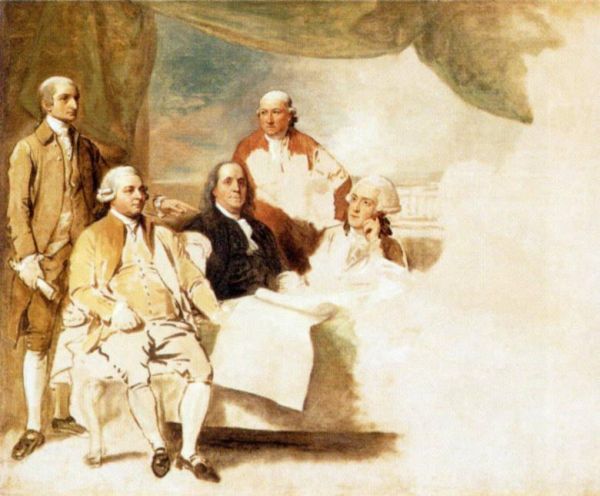
(Painting by Benjamin West of the American delegation at the Treaty of Paris)
Although the United States and Canada now maintain a long, peaceful border, the placement of that border has been in doubt since the Treaty of Paris (1783) in which Britain recognized the United States as an independent nation. That treaty attempted to draw borders over unexplored lands. The authors did the best that they could with their knowledge of geography. But, alas, one of the descriptions for the border between Maine and maritime Canada was problematic. The treaty says that US territory includes:
all Islands within twenty Leagues of any Part of the Shores of the United States, and lying between Lines to be drawn due East from the Points where the aforesaid Boundaries between Nova Scotia on the one Part and East Florida on the other shall, respectively, touch the Bay of Fundy and the Atlantic Ocean, excepting such Islands as now are or heretofore have been within the limits of the said Province of Nova Scotia.
I’ve bolded the parts of the text that are the source for the Machias Seal Island dispute.
As I’ve mentioned in a previous post, the eastern border of Maine was of great concern to the British. Some British officials coveted what Americans saw as their territory, and vice versa. Control of the Bay of Fundy was of great importance to British commissioners at the Treaty of Ghent (1814), which ended the War of 1812.
Now back to Machias Seal Island. The American argument is that it lies within 20 leagues (approximately 69 miles) of the coast of the United States.
The Canadian argument is that a land grant that pre-exists the Treaty of Paris defines the island as part of Nova Scotia. It built and has operated a lighthouse on the island since 1832.
Occasionally fishermen from the 2 nations have gotten into scraps about its ownership. Some Canadian citizens have staked mining claims to the island as a means of asserting Canadian sovereignty. The State of Maine has included the island on its maps of electoral districts.
But if possession is indeed 9/10ths of the law, then Machias Seal Island is Canadian. The United States has chosen not to press the issue.
Poro Point, La Union, PhilippinesThe Poro Point Lighthouse in La Union was built in 1885 during the Spanish colonial era to serve as beacon for ships and boats plying the sea at night. Bounded on the west by the west Philippine sea and on the east by the San Fernando bay, its apex is the highest elevation of the peninsula, and allows an unobstructed view of the panoramic landscape.
At the lighthouse, one can experience the beautiful sunrises and sunsets La Union is known for, while overlooking the undulating greens of the beautiful ‘The Cliffs Golf Course’ of Thunderbird Resorts and a coastline of pristine white sand. Atop the Poro Point Lighthouse, a tourist gets a glimpse of the best that Poto Point can offer.
Thus, the Poro Point Lighthouse is the perfect symbolism of the Poro Point Freeport Zone (PPFZ).
Featuring the Poro Point Lighthouse, a festival was conceptualized, in comparison with the ‘Panagbenga’ or the Flower Festival of Baguio City and the ‘Hot Air Balloon Festival’ of Clark. Dubbed as “SILLAG – The Poro Point Festival of Lights”, the festival, which will be launched on April 28, aims to boost the economic activities of the province and the whole region as a whole.
‘Sillag’ is an Iloco word which means moonbeam or illumination from the moon, and is similarly compared to the region’s booming business climate.
It is initiated by the Poro Point Management Corporation (PPMC), a member of the Bases Conversion and Development Authority Group which aims to promote the 6-hectare lighthouse property as a vital component of an Integrated Tourism Complex and attract domestic and tourists to create a mass market to encourage business and commerce in the PPFZ.
The ‘Sillag’ festival components include the following:
FLUVIAL PARADE – This is the highlight of the festival which will feature illuminated and decorated boats from participating government entities, business firms, and various stakeholders.
HOPE LANTERNS – The lanterns will be sold to government agencies, business firms, schools, various groups and organizations as well as individuals which will be released after the fluvial parade. Proceeds of which will go the PPMCs HELPS, a Corporate Social Responsibility Program of the corporation. HELPS stands for Health, Education and Environment, Livelihood Program including employment opportunities within the zone, and Strengthening Linkages.
MOA signing at the LIGHTHOUSE – The MOA covers the ‘Adopt-A-Lighthouse Project’ between PPMC and the Philippine Coast Guard (PCG). According to PPMC President and CEO Florante Gerdan, all lighthouses under the law is owned by the PCG. However, with the festival initiative, the PPMC requested PCG to handle and maintain the Poro Point Lighthouse.
UNVEILING OF THE CANVASS – The canvass will show the planned transformation of the lighthouse area. It will highlight the Spanish lighthouse, the renovated modern lighthouse, and refurbished shotgun house which could possibly be a museum and a souvenir shop at the same time.
It is also proposed in the UP Planades Development Framework Plan for the area that a multi-level observatory/viewing decks ending in circular platforms will be built that would serve as access points to water sports activities.
The six-hectare area will be built with restaurants, specialty shops, and green and open spaces, Gerdan said.
Other scheduled activities for the festival are concert featuring two bands; pyromusical show; children’s show featuring clown, magicians, jugglers and others to create a more festive atmosphere.
To draw more tourists, the scheduled one-day initial festival offers free rides to the area which is expected to be more complex and more exciting the coming years. (JCR-PIA 1, La Union)
The following extracts taken from early Victoria, British Columbia (BC) newspapers are credited to Leona Taylor for her excellent work in indexing the papers. Full information can be found here: ”Index of Historical Victoria Newspapers“, 2007-09.
Please Note: December 20, 2012 – I am continuing the series with this Lighthouse History #51 because the newspapers have now been indexed up to 1932. I quit posting at #50 as the extracts only went to 1926. They have now been extended from 1927 to 1932 so I will sift through the data for anything lighhouse! So far, a lot of it appears to be obituaries.
Henry Georgeson, 91, retired keeper of Active Pass lighthouse died Feb 3. [funeral Feb 10, 12…] [Colonist, 1927-02-04, p. 4]
Died May 9, 1927 at V, Captain James Christensen, 86. Resident here in 1864, aged 21, born in Denmark. He worked his way out in a cargo ship from Liverpool. Here he tried shore pursuits until he joined Surprise as mate, and in that capacity in 1869 came in contact with the loss of US bark John Bright, off Hesquiat… [see earlier accounts] Christensen was afterwards on schooner Alert, with Captain William Spring, and continued trading on the West Coast for some years. He was a pioneer in the sealing trade. His last journey to the west coast was to take material for the erection of Cape Beale lighthouse in 1876. He was successively in command of Beaver, Pilot, tugs Alexander and Lorne, and in 1891 became pilot for Victoria and Nanaimo districts [8 years]. In 1868 he married Mary Linklater, and leaves son, Andrew. His other son, Captain James Christensen, succeeded him as commander of Lorne and afterwards ran other tugs out of Victoria until 1894. In that year he lost his life with all the crew of steamer Estelle, which foundered off Cape Mudge. IOOF. Pallbearers: Captains J E Butler and J Gosse, E More, J Woodriff, W McKay, R Lawson. May 11, 14 – How Captain Christensen Conquered the Doubters… Family plot, H 093b094 E 23. [Colonist, 1927-05-08*] Continue reading Lighthouse History – 51 (1927-02-04 – 1927-06-29)→
This article may be a bit outside the scope of this website, but then maybe not.
Everybody loves a lighthouse, whether it is on the sea, in your garden or in your computer as is this PC/Mac program called Minecraft. This may not be to everybody’s interest but I am sure there are a few of my readers out there who play the game and might be interested.
I have never explored Minecraft, but a short description will more than help you understand the fascination. I might even give it a try. You all know my fascination with Lego!
The literal description: Minecraft is a first-person, free to play indie PC/Mac game created by one person, with crafting, building and exploration at its center. The graphics are straight out of 1991. There are no characters and there is no story. There are none of the “production values” that define gaming these days, but within those narrow confines lies one of the most innovative and endlessly fascinating game in existence… and it’s still in Alpha.
While there are various versions and builds available out, there are three basic play-modes to Minecraft: Single Player Creative, Multiplayer Creative, and Single Player Survival. All three plop you down into a huge, open world, filled with different natural resources you can exploit and bend to your will.
Single Player Creative mode is like an infinite LEGO set. You can create fantastic structures out of basic building blocks all day if you’d like. You can try it out for free, in-browser, right here. Multiplayer Creative is the same deal, with others. – g4tv.com
So, here is a short video on how to build a Minecraft lighthouse:
I mentioned earlier that I would like to do an article about lighthouses and how they are used in advertising. This lady, Ainsley Bevis, has researched logos using a lighthouse as the main theme. She has a beautiful collection below.
*****************************
30 Lovely Lighthouse Logos for Inspiration Posted by Ainsley | on November 27, 2012 | from Bloom Web Design
A lighthouse is a tower, building, or other type of structure designed to emit light from a system of lamps and lenses and used as an aid to navigation for maritime pilots at sea or on inland waterways. When a company decides on a symbol or monument for their business, they need to consider what type of audience to attract with their logo design. A lighthouse is a great choice when wanting to show that you’re business provides safety & strength for their customers.
Here I’ve compiled a collection of Logos dedicated to Lighthouses. These logos work well for these companies and all have unique ways of portraying lighthouses.
Ainsley Bevis is the owner of Bloom Web Design & Tutorials Share. She is a passionate and mostly self taught, Web and Graphic Designer based in Melbourne, Australia. Besides designing she also enjoys playing guitar, piano & walking her 2 dogs at the beach! Follow her on@BloomWebDesign & Facebook.
Doug Anderson, who helped with the donated models, is shown here discussing the hull of the HMS Victory, which he hopes to donate to the museum as a final piece in the full McNally Collection once a qualified modeler is found.
Special to The Record
When Katie McNally, from Ontario, N.Y., donated nine model boats to the St. Augustine Lighthouse & Museum in the autumn of 2011, one was held back. It wasn’t finished. It was the hull of the model of the British Ship HMS Victory, and it was being completed by her husband James G. (Jim) McNally, Jr. when he passed on in 2005.
The model ended up in the hands of the family friend, Doug Anderson, of Marsh Creek, who gave much of his time, driving and arranging the prior model ship donations to the St. Augustine Lighthouse & Museum, St. Augustine’s only Smithsonian Affiliate Museum. . . . more
[private]
The museum is looking for a volunteer modeler or modelers to take the unfinished hull in Anderson’s possession and complete it during the museum’s public hours. The volunteer or volunteers will be requested to work on the model and, at the same time, talk to the public about model building, why it is important to museums, and how it helps inform those who study ships and Atlantic Navigation. “There is much more to the art and craft of model building” than you can imagine, said museum curator Kathleen McCormick. The modelers can select from a variety of upcoming dates during the Sea Your History Weekends program funded by the St. Johns County Tourist Development Council.
If you are interested in helping to use your expertise as a modeler for the museum, during a Sea Your History Weekend, and would like to discuss the details please give a call to Loni Wellman, at 829-0745.
Impressive collection
The remarkable collection of ship models was donated as a study and exhibition collection by Katie McNally at the urging and with the support of her friend Doug Anderson. The model collection has been very popular with guests and very useful to archaeologists and educators when explaining the size and use of ships in St. Augustine, which is often misunderstood.
Archaeologists use ship models to help them study ship construction and they are useful to the public in understanding the size and shapes of vessels for different uses.
For example, the Chalpua was the work boat of St. Augustine, and was about 25 feet to 38 feet for use in local waters. Larger vessels like caravels, Nau’s or Galleon’s sailed by but usually did not anchor here in these shallow waters. Another example is that you can study the rigging of ships models to understand how differently rigged sails pull ships in different directions, and could for example have changed the landing site of Ponce de Leon when he located Florida. Museum archaeologists use ship models to tell authentic stories, and to explain the complex details of maritime navigation.
Today the Lighthouse and Museum is studying the British and the American Revolutionary period through diving on a wreck off shore, that comes from around 1782, when the British Fleet was helping to evacuate Charleston, S.C. The HMS Victory is a model of a famous British Vessel, probably much larger than the wreck in question, but maybe not. A variety of ships were used and many of them could not make it into the harbor.
Machias Seal Island is a 20-acre, treeless lump that sits nearly equidistant from Maine and New Brunswick. It, and the even smaller North Rock, lie in what local lobstermen call the gray zone, a 277-square-mile area of overlapping American and Canadian maritime claims.
The disagreement dates back to the 1783 Treaty of Paris that ended the Revolutionary War. The treaty assigned to the newly independent 13 colonies all islands within 20 leagues — about 70 miles — of the American shore. Since Machias Seal Island sits less than 10 miles from Maine, the American position has been that it is clearly United States soil.
But the treaty also excluded any island that had ever been part of Nova Scotia, and Canadians have pointed to a 17th-century British land grant they say proves the island was indeed part of that province, whose western portion became New Brunswick in the late 18th century.
Perhaps more important to the Canadian case, the British built a lighthouse on Machias Seal Island in 1832, which has been staffed ever since. Even today, two lighthouse keepers are regularly flown to the island by helicopter for 28-day shifts to operate a light — even though, like every other lighthouse in Canada, it is automated. – Opinion Pages – NY Times
AT a time when territorial disputes over uninhabited outcrops in the East China Sea have led to smashed cars and skulls in China, a similar, if less dramatic, dispute over two remote rocks in the Gulf of Maine smolders between the United States and Canada.
Machias Seal Island and nearby North Rock are the only pieces of land that the two countries both claim after more than 230 years of vigorous and sometimes violent border-making between them.
Except for the occasional jousting of lobster boats, this boundary dispute floats far below the surface of public or official attention, no doubt reflecting the apparent lack of valuable natural resources and a reluctance to cede territory, no matter how small.
But if we are unlikely to resort to arms anytime soon, the clashes in Asia have shown how seemingly minor border disputes can suddenly stoke regional and nationalistic tensions. Our relaxed attitude toward these remote rocks may well be a mistake.
While the United States and Canada have other maritime boundary disputes along their 5,525-mile border, the world’s longest, this is the only one left that involves actual chunks of land.
Machias Seal Island is a 20-acre, treeless lump that sits nearly equidistant from Maine and New Brunswick. It, and the even smaller North Rock, lie in what local lobstermen call the gray zone, a 277-square-mile area of overlapping American and Canadian maritime claims.
The disagreement dates back to the 1783 Treaty of Paris that ended the Revolutionary War. The treaty assigned to the newly independent 13 colonies all islands within 20 leagues — about 70 miles — of the American shore. Since Machias Seal Island sits less than 10 miles from Maine, the American position has been that it is clearly United States soil.
But the treaty also excluded any island that had ever been part of Nova Scotia, and Canadians have pointed to a 17th-century British land grant they say proves the island was indeed part of that province, whose western portion became New Brunswick in the late 18th century.
Perhaps more important to the Canadian case, the British built a lighthouse on Machias Seal Island in 1832, which has been staffed ever since. Even today, two lighthouse keepers are regularly flown to the island by helicopter for 28-day shifts to operate a light — even though, like every other lighthouse in Canada, it is automated.
While abundant legal arguments surround Machias Seal Island, natural resources are far less evident. No oil or natural gas has been discovered in the area, nor has it had any strategic significance since it served as a lookout for German U-boats during World War I.
Tour boats from Maine and New Brunswick carry strictly limited numbers of bird watchers to the island to see nesting Atlantic puffins. And the surrounding waters contain lobsters that, thanks to different regulatory schemes and overlapping claims, have occasionally sparked clashes between Maine and New Brunswick lobstermen, although a bumper lobster crop this summer has slackened demand for gray zone crustaceans.
But the lack of hydrocarbons and the current lobster glut make this an ideal time to color in the gray zone.
The United States and Canada settled all their other maritime differences in the Gulf of Maine in 1984 by submitting their claims to the International Court of Justice for arbitration. They could have included the gray zone in that case, but did not. The Canadians had refused an earlier American arbitration proposal by saying their case was so strong that agreeing to arbitration would bring their title into question.
This attitude calls for re-examination. The fact that so little in the way of resources appears to be at stake, far from justifying the status quo, should be the main reason for resolving the issue. And for those concerned about blowback from “giving away” territory, letting the international court decide the case provides the most political cover.
As China and Japan can attest, border disputes do not go away; they fester. And when other factors push them back to the surface — the discovery of valuable resources, an assertion of national pride, a mishap at sea — the stakes can suddenly rise to a point where easy solutions become impossible.
Before that happens, we should put this last land dispute behind us, and earn our reputation for running the longest peaceful border in the world.
Stephen R. Kelly is the associate director of the Center for Canadian Studies at Duke University and a retired American diplomat who served twice in Canada.
A version of this op-ed appeared in print on November 27, 2012, on page A31 of the New York edition with the headline: Good Neighbors, Bad Border.
Machias Seal Island is a 20-acre, treeless lump that sits nearly equidistant from Maine and New Brunswick. It, and the even smaller North Rock, lie in what local lobstermen call the gray zone, a 277-square-mile area of overlapping American and Canadian maritime claims.
The disagreement dates back to the 1783 Treaty of Paris that ended the Revolutionary War. The treaty assigned to the newly independent 13 colonies all islands within 20 leagues — about 70 miles — of the American shore. Since Machias Seal Island sits less than 10 miles from Maine, the American position has been that it is clearly United States soil.
But the treaty also excluded any island that had ever been part of Nova Scotia, and Canadians have pointed to a 17th-century British land grant they say proves the island was indeed part of that province, whose western portion became New Brunswick in the late 18th century.
Perhaps more important to the Canadian case, the British built a lighthouse on Machias Seal Island in 1832, which has been staffed ever since. Even today, two lighthouse keepers are regularly flown to the island by helicopter for 28-day shifts to operate a light — even though, like every other lighthouse in Canada, it is automated.
Kelly reasonably suspects that the lack of natural resources in the region have made both sides reluctant to rock the boat by submitting their claims to the International Court of Justice for arbitration, as they have with other disputes. There’s simply nothing there worth the risk of losing the case and having to explain to voters why you “gave away” U.S. or Canadian territory. In any case, from the photos on Flickr it looks like the Canadian government has staked a pretty permanent claim to the island, so this one may be de facto settled.
Machias is the only U.S.-Canadian border conflict that involves land, but the sea border is disputed in a few places. Here’s Wikipedia’s list:
Strait of Juan de Fuca48°17?58?N 124°02?58?W (Washington /British Columbia) The middle-water line is the boundary, but the governments of both Canada and British Columbia disagree and support two differing boundary definitions that would extend the line into the Pacific Ocean to provide a more definite Exclusive Economic Zone (EEZ) boundary.
Dixon Entrance54°22?N 132°20?W (Alaska / British Columbia) is wholly administered by Canada as part of its territorial waters, but the US supports a middle-water line boundary, thereby providing the US more maritime waters. Canada claims that a 1903 treaty demarcation is the international maritime boundary, while the United States holds that the maritime boundary is an equidistant line between the islands that form the Dixon Entrance, extending as far east as the middle-water line with Hecate Strait to the south and Clarence Strait to the north.[2]
Yukon–Alaska dispute, Beaufort Sea72°01?40?N 137°02?30?W(Alaska / Yukon) Canada supports an extension into the sea of the land boundary between Yukon and Alaska. The US does not, but instead supports an extended sea boundary into the Canadian portion of the Beaufort Sea. Such a demarcation means that a minor portion of Northwest Territories EEZ in the polar region is claimed by Alaska, because the EEZ boundary between Northwest Territories and Yukon follows a straight north-south line into the sea. US claims would create a triangular shaped EEZ for Yukon. This is mainly an Alaska-Yukon dispute.
Northwest Passage; Canada claims the passage as part of its “internal waters” belonging to Canada, while the United States regards it as an “international strait” (a strait accommodating open international traffic).
The last two might get a bit more controversial as resource competition in the rapidly melting Arctic heats up.
Well, first of all it is not a lighthouse, so if you are not interested please continue on to another article, but I think you will find this fascinating.
Why is then called a lighthouse? Well, it can be seen from many miles away for over 160 nights a year over Lake Maracaibo in Venezuela. I would never have known about it except that my article antennae are tuned to anything lighthouse. When I heard about it, I just had to investigate and bring it to your attention. This is quite unique and the only place in the world that has this phenomena in such intensity.
It is said to have the hottest flash density rate in the world, with an annual average of 181 lightning flashes per square kilometre.During peak months there can be as many as fifty (50) discharges every minute. That is a nearly continuous thunderstorm with up to 20,000 flashes of lightning per night. That is a lot of lightning – the most persistent thunderstorm of the world!
The storms (and associated lightning) are likely the result of the winds blowing across the Maracaibo Lake and surrounding swampy plains. These air masses inevitably meet the high mountain ridges of the Andes, the Perijá Mountains (3,750m), and Mérida’s Cordillera, enclosing the plain from three sides. The heat and moisture collected across the plains creates electrical charges and, as the air masses are destabilized at the mountain ridges, result in almost continual thunderstorm activity.
The phenomenon is characterized by almost continuous lightning, mostly within the clouds, which is produced in a large vertical development of clouds that form large electric arcs between 2 and 10 km in height (or more). The lightning tends to start approximately one hour after dusk.
Among the major modern studies there is the one done by Melchor Centeno, who attributes the origin of the thunderstorms to closed wind circulation in the region.
 The following extracts taken from early Victoria, British Columbia (BC) newspapers are credited to Leona Taylor for her excellent work in indexing the papers. Full information can be found here: ”Index of Historical Victoria Newspapers“, 2007-09.


