Category Archives: Equipment

Re-inventing the Wheel, er, The Paddleboard


This not a lighthouse story, but it shows what interests a lighthouse keeper. If you live near the sea, you are always interested in ways and means of travelling, fishing , and exploring on the ocean. It is only natural. Here is my newest find – a SUP!

****************************

After posting the story “Stand” – An Adventure Documentary on November 14, 2012, I was really intrigued by the surfboards the people were using in the film.  They were not really surfboards as they appeared to be too heavy even though made of native British Columbia (BC) cedar wood.

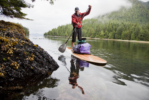
A Cedar Strip Stand Up Paddleboard (SUP)

As you can see from the photo above, they are called a Stand Up Paddleboard (SUP). I had never heard of them before, and thought they would be ideal for adventurers on the BC coast, or anywhere! Continue reading Re-inventing the Wheel, er, The Paddleboard

Reprint – Restoring Canaveral Light – Brick by Brick!


Restoring Canaveral Light – Brick by Brick!


The mission statement of the Cape Canaveral Lighthouse Foundation is  “To Assist the 45th Space Wing in preserving, protecting, and interpreting the Cape Canaveral Lighthouse and its historical significance to the Florida Space Coast, State of Florida, and our Nation.” The US Air Force owns and maintains Cape Canaveral Light, but the Foundation exists to be of assistance in its restoration and to share its remarkable history.

In many ways Cape Canaveral and the Lighthouse is a bridge between the age of exploration and exploration yet to come; a bridge between the sea and the stars!

On October 13th, 2012 I attended a gathering at the Canaveral Lighthouse with my father to celebrate the progress having been made on the restoration of this special and significant beacon. Although, we had visited the light by special permission a couple of years ago in order to photograph, I did not then have the opportunity to see the interior of the tower. Saturday, October 13th, could not have been a more perfect day to gather, discuss goals, walk the newly built Keeper’s Brick Paver Walkway, and climb!! I have to say right here that I was amazed that my 88 year old father was able to navigate the stairs better than I did!  The metal lighthouse is lined with brick and the winding stairs curl upwards around a center pole with no hand railing along the brick walls. Of course, it was probably because I was lugging my heavy camera!! Probably!! Continue reading Reprint – Restoring Canaveral Light – Brick by Brick!

Reprint – New Tsunami Warning Protocol Rolled Out in B.C.

New tsunami warning protocol rolled out in B.C.

New system tested by magnitude 6.4 quake off Alaska coast on Monday

CBC News 

Posted: Nov 12, 2012 2:43 PM PT 

Last Updated: Nov 12, 2012 7:05 PM PT 

[media url=”https://ccanadaht3.com/wp-content/uploads/2012/11/bc-tsunami-warning-williams-11_32291146.flv” width=”400″ height=”350″]

The B.C. government is upgrading its tsunami warning plans following delays broadcasting emergency information after a magnitude 7.7 earthquake last month.

After the quake struck off the west coast of Haida Gwaii on Oct. 27 at 8:04 p.m. PT, emergency officials in B.C. did not issue any sort of tsunami alert or advisory for 51 minutes, leaving many civic leaders in B.C. wondering what they were supposed to do. . . . more

[private]

But many communities did start evacuations based on notifications issued by U.S. officials just minutes after the quake was detected.


B.C. has rolled out a new system to issue tsunami alerts and advisories faster to the public using twitter, email and SMS. (Emergency Info B.C./Twitter)

After questions about B.C.’s response, Justice Minister Shirley Bond ordered a review of the notification protocol, and on Monday she rolled out the changes.

Under the new protocol, when emergency officials in B.C. receive an alert or advisory from the West Coast and Alaska Tsunami Warning Centre, they will immediately email it to a list of prioritized local authorities, emergency responders and media outlets.

The alert will also be immediately broadcast on Twitter thru the @EmergencyInfoBC account and posted on the Emergency Info B.C. website.

Provincial emergency officials will then follow up with direct phone calls to local authorities starting with those in areas of highest risk.

Alaska earthquake tests new protocol

The system appeared to be in operation when a magnitude 6.4 earthquake struck about 248 km off the coast of Alaska on Monday afternoon at 12:42 p.m. PT.

At 12:46 p.m., the @NWS_WCATWC twitter account broadcast a message saying there was no tsunami danger for the West Coast from Alaska to California.

A modified version of the tweet was retweeted on the Emergency Info B.C. account at 12:50 p.m.

Other improvements to the Emergency Info B.C. website will include:

  • A mobile version for use on smartphones.
  • An RSS feed for updates
  • Development of an interactive map for tsunami warning zones.
  • Digital audio recordings of tsunami warnings posted online.

Justice Minister Shirley Bond said the changes are the direct result of a review that was conducted following the Oct. 27 earthquake.

“We made a commitment to review our earthquake and tsunami response and we are now taking action to implement some of the early recommendations identified,” said Bond.

“We have also been in direct contact with those mayors who expressed concern about B.C.’s emergency response reaction time and have communicated with regional district board chairs, local authorities and first responders, gathering their feedback.”

How to sign up for tsunami warnings:


[/private]

Reprint – Cape Canaveral Light – Warden of the Sea, Launchpad to the Stars!


The following story is the first of two parts on the Cape Canaveral lighthouse by Judy Lovell, a photographer extraordinaire, who runs a WordPress blog called Janthina Images.

Besides this article, and the one following, please view her image gallery on her website as well. In the gallery she has some lovely photos of Florida lighthouses with prints available for sale. Enjoy, and drop by her website occasionally for different articles. If you wish to view the image gallery as a slideshow, please click here.

***********************************

Cape Canaveral Light – Warden of the Sea, Launchpad to the Stars!

They fill that night with Knowledge. A thousand ships go by,
A thousand captains bless them, so bright and proud and high:
The world’s dark capes they glamour; or low on sand banks dread,
They, crouching, mark a pathway between the Quick and Dead —
Like star points in the ether
They bring the seamen ease,
These Lords of Wind and Weather
These Wardens of the Seas!

…Edwin James Brady…

Lighthouses have long stood at the edges of the world, lonely outposts maintained by devoted souls to ensure the safety of ships at sea. But, only one remarkable beacon was destined to illuminate the path for ships of space! But how did this happen? How did a lighthouse built on a hook of sand jutting out into the Atlantic to protect mariners from dangerous currents become a front row witness to the advent of the Space Age?

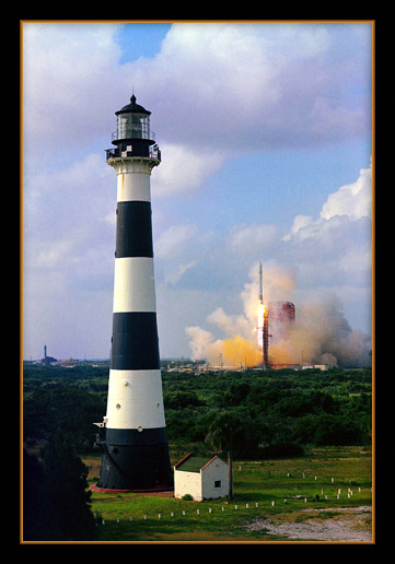
Rocket Launch with Canaveral Lighthouse is courtesy NASA Continue reading Reprint – Cape Canaveral Light – Warden of the Sea, Launchpad to the Stars!

Reprint – The Lighthouses of British Columbia


In February 2012 I wrote an article on the seawater sample collecting from the BC lighthouses here My story discussed the duties and .trials a lightkeeper had while obtaining the samples. This story details the use of the information collected from a scientist’s point of view.

********************************

The Lighthouses of British Columbia

by Allan Roberts

Not only are British Columbia’s lighthouses picturesque, and important for navigational purposes, but they also collect oceanographic data! You can access sea surface temperature (SST) and surface salinity data at the following website:

www.pac.dfo-mpo.gc.ca/science/oceans/data-donnees/lighthouses-phares/index-eng.htm

This website also has photographs of the lighthouses. (See below.)

Figure 1. Race Rocks (48.180 N, 123.320 W). Photo credit: Fisheries and Oceans Canada. Photograph obtained from: http://www.pac.dfo-mpo.gc.ca/science/oceans/data-donnees/lighthouses-phares/index-eng.htm

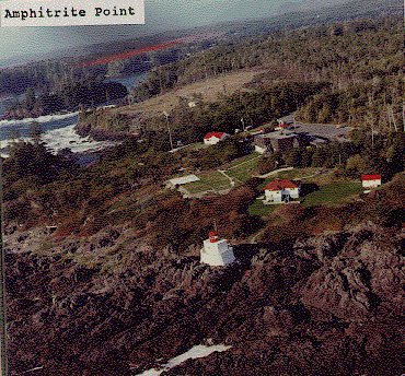
Figure 2. Amphitrite Point (48.550 N, 125.320 W). Photo credit: Fisheries and Oceans Canada. Photograph obtained from: www.pac.dfo-mpo.gc.ca/science/oceans/data-donnees/lighthouses-phares/index-eng.htm

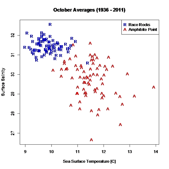
I’ve compiled and plotted some of the data from the Race Rocks and Amphitrite Point lighthouses. Race Rocks (Figure 1) is near Victoria, while Amphitrite Point (Figure 2), on the west coast of Vancouver Island, is closer to Bamfield. The data plotted in Figure 3 are monthly averages for October, covering the years 1936 to 2011. The plot shows an evident contrast in SST and surface salinity between the two sites.

Figure 3. October averages for surface salinity plotted versus October averages for sea surface temperature. The data are from two different lighthouses: Race Rocks (48.180 N, 123.320 W) and Amphitrite Point (48.550 N, 125.320 W). Race Rocks is near Victoria, while Amphitrite Point is on the west coast of Vancouver Island. Data are not plotted for 1940 and 2007, because of missing values. Graphics produced with R (R Core Team, 2012). Data source: Fisheries and Oceans Canada, www.pac.dfo-mpo.gc.ca/science/oceans/data-donnees/lighthouses-phares/index-eng.htm (accessed Oct. 9, 2012).

A peculiarity of the lighthouse data is that they are not collected at the same time every day, as explained on the lighthouse data website: “Sampling occurs at or near the daytime high tide” (Fisheries and Oceans Canada, 2012).

If you want data for ocean bottom temperature and salinity (as opposed to surface temperature and salinity), such data are available through NEPTUNE Canada, and through the VENUS network (NEPTUNE Canada, 2012; VENUS, 2012).

Citations

Fisheries and Oceans Canada. 2012. Website. Accessed Oct., 9, 2012:http://www.pac.dfo-mpo.gc.ca/science/oceans/data-donnees/lighthouses-phares/index-eng.htm

NEPTUNE Canada, 2012. Website: www.neptunecanada.com

R Core Team, 2012. R: A language and environment for statistical computing. R Foundation for Statistical Computing, Vienna, Austria.

VENUS network, 2012. Website: www.venus.uvic.ca

Tides

photo Paul Kurbis

One of the reasons for the establishment of a lighthouse is to mark the dangers from the effect of extreme tides (low and high) on surrounding lands, islands, waterways, and beaches. 

Look at the photo on the left of my old lighthouse at McInnes Island at low tide (click for a larger version). We can tell it is low tide because the kelp is exposed on the rocks, and the high tide mark on the rocks is marked by a dirty black line. Here on the Pacific Coast of Canada, the tides come in and go out twice a day, and the range is between seventeen (17) and twenty-one (21) feet (6 to 7 meters)!

Note the small rock at dead center, bottom of the photo. At high tide that would be covered and become a menace to navigation. In this case this is not a marked shipping channel so no marker is necessary. The reason for the lighthouse (visible on the left of the large island) is that it was listed as a landfall light. A marker for ships coming in from the Pacific Ocean to the British Columbia coastline, and also a marker for the entrance to Milbanke Sound. It really doesn’t mark the island as dangerous; just an indicator of a mariner’s location on the ocean.

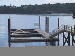
Example of a floating dock

To return to a docked boat on the BC coast after a few hours of sightseeing or shopping is sometimes a surprise for many tourists. The docks for the boats are built to float up and down on fixed pilings to accommodate the 21 foot tides (see photo left). To get onto the dock you walk up or down a ramp. A roller on the lower end rolls along the dock as the tide rises or falls. The top part of the ramp is hinged.

The tides change approximately every six hours, so if you left your boat and walked up the steep ramp to the topside dock at 10 AM (low tide) and came back at 2 PM (4 hours difference), the ramp would be almost horizontal (high tide). If you had lots of heavy groceries to move it was always a good idea to plan at what time of day you wanted to move them! Continue reading Tides

Because John Coldwell Has An Inquiring Mind . . .

I just recently married a lovely Filipino lady here in the Philippines. The marriage was held on the beach at the Drill Shack Resort just outside Dumaguete, Negros Oriental, Philippines – actually closer to Dauin.

While in the Dumaguete area I met a Canadian friend, Brian Waddington, who used to live on a lighthouse near to mine at McInnes Island, BC. Brian wrote on August 27, 2012 on his Blogpost:

Because John Coldwell Has An Inquiring Mind I Will Publicly Embarrass Myself And Give Him And His Bride To Be This Story As A Wedding Present

John was the senior keeper at McInnes when I became the junior keeper at Ivory. He retired after 32 years as a keeper. He now runs a truly informative website about the life of a lighthouse keeper on the west coast of Canada. If you have ever wondered about the life of a keeper click on his name.
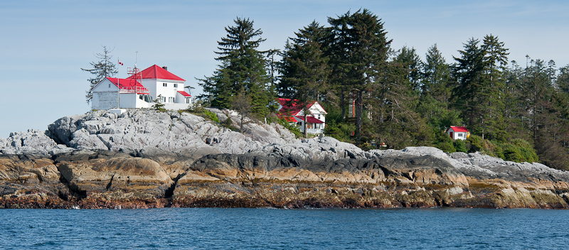
From left to right; workshop and senior keepers house, junior keeper house and garage, landing platform (red pole) control shed for hiline.

Ivory Island is a lighthouse on the north-west coast of Canada. Thirty plus years later I still dream of Ivory. To say it was a seminal time in my life is simply an understatement. Ivory was where I found the start of my spiritual path. Ivory is where the only child I have helped to conceive and father was created. I met my first two spiritual mentors while I was there. Ivory Island introduced me to the Thomas Crosby V which led me to Haisla village which allowed for the occasion where I met my future wife which is why I now live in the Philippines.

Some of my memories are sublime, some are joyous, some are mysterious but this one is just plain embarrassing. First you need a little background information. There are basically two ways to deliver anything to Ivory – helicopter or ship. Helicopter is quick and easy but not so good for heavy or bulky goods.
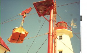
When goods are brought in by boat the cargo ship anchors, lowers the work boat and they bring the goods to where the ‘hook’ is lowered via the hi line. (look very closely at the first picture, just above the control shed you will see the hi-line running from the tall red pole down towards the water). Once the work boat crew secures the cargo to the hook it is picked up, wound in, lowered, unhooked and the hook is lowered again for the next load. Simple if everything works right not so simple when it doesn’t. This day it didn’t.

Perhaps I allowed the hook to pick up too much speed as gravity pulled it back to the water. Perhaps the stopper and the hook did not mate properly because a gust of wind moved the mechanism at a crucial point. In any case instead of doing what it was supposed to do the hook plunged into the water. Luckily this occurs with some frequency so the work boat was well clear of the rapidly descending hook. The other times this had happened I simply wound the hook in the way a fisherman reels in his line. The hook comes up sets itself properly and then I would again lower it so the work boat could hook up another load.

This time the hook snagged on something. With no way of knowing if it was snagged on a sunken log, a small easily moved rock or something worse I decided to apply a little more power and see what would happen. Bad decision! All of a sudden guy wires are snapping and the tower is starting to bend. No more cargo came ashore that day. What did come ashore a few days later was a five man work crew from Prince Rupert via helicopter with most of what was needed to fix the hi-line.

I say most… what they did not have was the bit for drilling the holes needed to do to put in the new anchoring pins. The drill bit was flown up from Victoria via helicopter. My bad choice was starting to get expensive. It got even more expensive after they had drilled four (if memory serves) five foot long 2 inch wide holes for the pins and then spent a day or two trying to hammer the 2 inch steel pins into the 2 inch holes.

For the next few days the work crew enjoyed a mini vacation while they waited for the proper sized drill bit. It is just possible that this had become such an embarrassment of errors to one and all concerned that they could not fire me without firing some bosses too. In any case I was and am ever so thankful I wasn’t fired.

There you are John my wedding gift to you, your future wife and your web site. Hope you can use it and it brings a smile to your face.

*******************************

Thanks Brian. We could not have had a better wedding gift!
Government Contracts to Paint Lighthouses

The title is a tiny bit misleading. The government is not contracting to paint the lighthouse (is not doing the job themselves using government personnel as in the olden days) but is contracting out to private persons to do the work previously done by government workers.

An interesting article on the Peggys1 Cove lighthouse in Nova Scotia says:


Peggys Cove lighthouse crumbling
Province, feds negotiate while structure suffers


However, dealing with the problem is not as straightforward as sending someone the tab. Peggys Cove is owned by the federal government, which is currently getting out of the lighthouse business. The Nova Scotia government is in negotiations to take over the site, but no date has been set for completion of the talks.

So who is going to paint Peggys Cove, and many other abandoned lighthouses?

One of the commenter’s on the above site made the following reply:

Here’s the link for all those interested in bidding. Go create an account on Merx and bid away your $400.00 to paint it.

http://www.merx.com/English/nonmember.asp?WCE=Show&TAB=1&State=1&hcode=DSmmOnl5zU6FVjU16CWLSQ%3D%3D

Now that Merx site is very interesting. It shows Canadian Public Tenders for jobs the Canadian Government puts out for bids. I searched but could not finds anything lighthouse-related, but maybe you will have better luck. Let me know if you find anything.

There are some interesting jobs available, but one thing comes to mind. What has happened to the Public Works Department of the Canadian Government? They used to do all the painting and construction projects..Does Public Works no longer exist?

Aha! I found it! It is now called Public Works and Government Services Canada (PWGSC). They pay me my pension, but do they do anything else? Check out PWGSC website and see if you can find out.

Not much there about painting old lighthouses. Lots on procurement and disposal though. So I guess they just buy stuff and dispose of it when no longer needed. Is any reader working for PWGSC that can better fill us in on the workings of PWGSC?

So, unless the community is going to do the work and pay for the job itself, I guess Canadian lighthouse are headed for a dim future (pun intended).

FOOTNOTE:
1 Peggys Cove (2009 population: approx. 46), also known as Peggy’s Cove from 1961 to 1976, is a small rural community located on the eastern shore of St. Margarets Bay in Nova Scotia’s Halifax Regional Municipality.- Wikipedia

Another Lighthouse Destroyed by the Sea! 1967


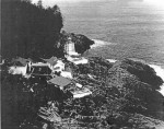
Pine Island lighthouse after the storm

On February 18, 1967 at 00:30 hours, a giant wall of water slammed into Pine Island, destroying buildings and washing away equipment and personal possessions. [B&W photo left] The following article describes it well.
(If anyone knows the author, or or where this article came from, please let me know so I can give credit. It appeared with the photo on the left of the page and the page was numbered 13. Thanks.- JAC)

*****************************
Fury . . . and British Columbia

Pine Island, B.C. – The worst damage in the history of British Columbia’s coastal lighthouses was inflicted here ­recently when a 50 foot wall of water slammed into this tiny island during a raging storm. Continue reading Another Lighthouse Destroyed by the Sea! 1967

Reprint – DFO Shutting Down Coast Guard Radio Stations, but Prince Rupert’s Will Be Expanded


I wrote an article on January 04, 2012 entitled MCTS To Lose Staff To Save Money. After that date, the department of Fisheries and Oceans (DFO or F&O) have changed their plans. They are now closing whole stations instead of a removing a few men! The news article below is well written and explains what is planned for the BC coast. If all goes through we will have only two (2) MCTS stations on the whole BC coast, relying on mountaintop repeaters to reply to ships at sea.

I can also see soon that their plans will include again trying to de-staff the lighthouses. Pretty soon the whole BC coast will be bare of any support for boaters!

***********************************

By Alan S. Hale – The Northern View
Published: May 18, 2012 4:00 PM
Updated: May 18, 2012 4:59 PM

The Coast Guard communication monitoring station in Prince Rupert will be even more important to ensuring the safety of seafarers. The Prince Rupert station will be one of only two “modernized” coast guard stations in the entire province – the other one being in Sydney. Continue reading Reprint – DFO Shutting Down Coast Guard Radio Stations, but Prince Rupert’s Will Be Expanded