Category Archives: Information

Mise Tales Fourteen


For an update on what a Mise Tale is then please see Mise Tales One.

A Lighthouse Opera?

I had never heard of a lighthouse opera until now, and being not a fan of operas, I was a bit skeptical as well. OK, I found a Youtube video of The Lighthouse, an opera by Sir Peter Maxwell Davies and I am not impressed. This is a short ten (10) minute cut from the opera.

[media url=”http://www.youtube.com/watch?v=t4FX5Dd7k-o” width=”400″ height=”350″]
 
October 12, 2012 – Now, I came across another review in The Telegraph of a different performance by the English Touring Opera. The comments were:

Few instances of that staple mystery, the unexplained maritime vanishing (as in the Mary Celeste or the Bermuda Triangle) can be more baffling than that of the three keepers who dematerialised without trace from their lighthouse in the Hebrides in 1900.
Peter Maxwell Davies’s fictionalised reconstruction of this tale has been hugely successful since its premiere in 1980, and Continue reading Mise Tales Fourteen

Reprint – The Lighthouses of British Columbia


In February 2012 I wrote an article on the seawater sample collecting from the BC lighthouses here My story discussed the duties and .trials a lightkeeper had while obtaining the samples. This story details the use of the information collected from a scientist’s point of view.

********************************

The Lighthouses of British Columbia

by Allan Roberts

Not only are British Columbia’s lighthouses picturesque, and important for navigational purposes, but they also collect oceanographic data! You can access sea surface temperature (SST) and surface salinity data at the following website:

www.pac.dfo-mpo.gc.ca/science/oceans/data-donnees/lighthouses-phares/index-eng.htm

This website also has photographs of the lighthouses. (See below.)

Figure 1. Race Rocks (48.180 N, 123.320 W). Photo credit: Fisheries and Oceans Canada. Photograph obtained from: http://www.pac.dfo-mpo.gc.ca/science/oceans/data-donnees/lighthouses-phares/index-eng.htm

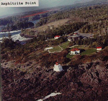
Figure 2. Amphitrite Point (48.550 N, 125.320 W). Photo credit: Fisheries and Oceans Canada. Photograph obtained from: www.pac.dfo-mpo.gc.ca/science/oceans/data-donnees/lighthouses-phares/index-eng.htm

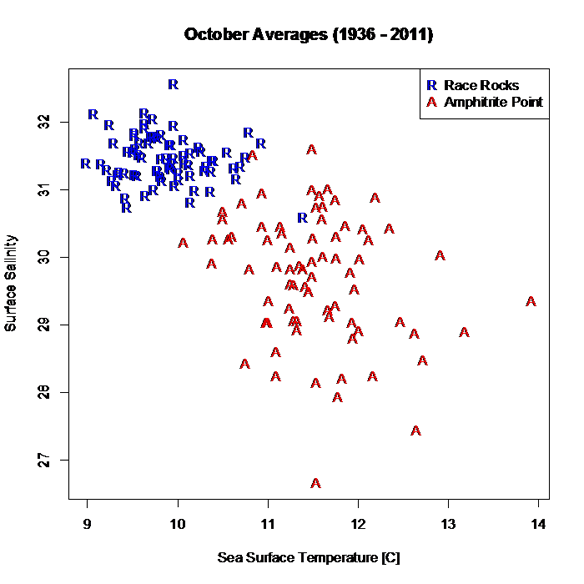
I’ve compiled and plotted some of the data from the Race Rocks and Amphitrite Point lighthouses. Race Rocks (Figure 1) is near Victoria, while Amphitrite Point (Figure 2), on the west coast of Vancouver Island, is closer to Bamfield. The data plotted in Figure 3 are monthly averages for October, covering the years 1936 to 2011. The plot shows an evident contrast in SST and surface salinity between the two sites.

Figure 3. October averages for surface salinity plotted versus October averages for sea surface temperature. The data are from two different lighthouses: Race Rocks (48.180 N, 123.320 W) and Amphitrite Point (48.550 N, 125.320 W). Race Rocks is near Victoria, while Amphitrite Point is on the west coast of Vancouver Island. Data are not plotted for 1940 and 2007, because of missing values. Graphics produced with R (R Core Team, 2012). Data source: Fisheries and Oceans Canada, www.pac.dfo-mpo.gc.ca/science/oceans/data-donnees/lighthouses-phares/index-eng.htm (accessed Oct. 9, 2012).

A peculiarity of the lighthouse data is that they are not collected at the same time every day, as explained on the lighthouse data website: “Sampling occurs at or near the daytime high tide” (Fisheries and Oceans Canada, 2012).

If you want data for ocean bottom temperature and salinity (as opposed to surface temperature and salinity), such data are available through NEPTUNE Canada, and through the VENUS network (NEPTUNE Canada, 2012; VENUS, 2012).

Citations

Fisheries and Oceans Canada. 2012. Website. Accessed Oct., 9, 2012:http://www.pac.dfo-mpo.gc.ca/science/oceans/data-donnees/lighthouses-phares/index-eng.htm

NEPTUNE Canada, 2012. Website: www.neptunecanada.com

R Core Team, 2012. R: A language and environment for statistical computing. R Foundation for Statistical Computing, Vienna, Austria.

VENUS network, 2012. Website: www.venus.uvic.ca

Chris Mills – Canadian Lighthouse Photographs


Canadian Lighthouse Photographs

New website is coming.
http://www3.ns.sympatico.ca/ketm/
is no longer online


Chris Mills
1121 Ketch Harbour Rd.
Ketch Harbour, Nova Scotia  B3V 1K7


British Columbia | Nova Scotia | Prince Edward Island | New Brunswick | Newfoundland

Chris Mills served as a lighthouse keeper for the Canadian Coast Guard on both the Atlantic and Pacific coasts.

He is currently co-chair of a committee which is recruiting Members of Parliament in support of a private members bill to protect lighthouses.  To see how you can help, visit this site:  Canada Needs a Lighthouse Protection Act.

Photographs and enlargements are for sale. Contact Chris Mills for price information.
All photographs and slides in the collection are identified, dated and signed.

Chris Mills is also author of the book on Nova Scotia lighthouses Lighthouse Legacies available from Amazon.ca


Sambro Island restoration project


BRITISH COLUMBIA

Some of these photos may be viewed at the Lighthouses of British Columbia site.

Green Island (1994, 1995) 250 colour photos, 70 colour slides in collection. All aspects of the station and island documented — aerial views, sea views, night views, details of light and lighthouse, lightkeepers, Coast Guard helicopters, surrounding islands and seascapes.


Langara Island (1994, 1996) 250 colour and 25 black and white photos, 180 colour slides in collection. All aspects of station documented — aerial views, night views, detailed views of 1913 First Order Fresnel Lens (manufactured by Chance Brothers), light tower and lantern, lightkeepers, dwellings, interior of engine room, old cabin on island, face carved in tree, shoreline views, lightkeeper’s goats, stormy seas.


Triple Island (1994) 24 colour photos in collection. Aerial views, third order Fresnel lens, lightkeeper, detailed views of lighthouse structure, interior of workshop and engine room.


Bonilla Island (1994) 250 colour photos in collection. Many aspects of station — aerial views, sea views, night views, shoreline views (including Japanese glass fishing floats), lightkeepers, dwellings, engine room interior, light tower. (NOTE: this collection will be expanded during Sept/Oct 1996)


Boat Bluff (1994-1996) 160 colour photos in collection. All aspects of station — aerial views, sea views, night views, details of light tower, fog horns , engine room, main light (including views of keeper inspecting light at night, inspection of light and bulbs during day), views of station and mountains from 1000 foot hill across the channel from lightstation, snow views, old hand fog horn, three modern plastic lenses, sunrise views, surrounding bays and inlets, Santa and Mrs. Claus visit 1994. (NOTE: Available as of Dec. 1996 — selection of a further 200 colour and b&w prints taken during August 1996, including Coast Guard ship and work crews supplying station.)


Ivory Island (1994-1996) 600+ colour and 36 black and white photos, 100 colour slides in collection. All aspects of the lightstation — 30 aerial views, sea views, night views, lighthouse, keepers, dwellings inside and out, engine room, main light, surrounding area, beaches, salmon fishing, snow, totem poles, artist and photographer at work at the lightstation, Coast Guard helicopters, sunsets, shoreline and forest, various tidal life (sea stars, crabs, etc.), local minor beacon lights, 25th annual Santa and Mrs. Claus visit December 1995.


McInnes Island (1994, 1995) 48 colour photos, 22 colour slides in collection. Aerial views, lighthouse structure, radio room, keeper, detail of lantern and main light, large thunder cloud formations.


Dryad Point (1995) 32 colour photos in collection. Aerial views, light tower, main light, keeper and daughter, keeper and main light, dwelling. (NOTE: This collection will be expanded during 1997)


Addenbroke Island (1994) 14 colour photos in collection. Aerial views.


Egg Island (1994) 10 colour photos in collection. Aerial views.


Pine Island (1994) 3 colour photos in collection. Aerial views.


Scarlett Point (1994) 2 colour photos. Aerial views.


Point Atkinson (1994) 14 black and white photos in collection. Light tower, keeper and main light, station dwellings and exterior of radio/engine room.


Brockton Point (1994) 5 black and white photos in collection. Light tower.


Porlier Pass (1994) 32 colour photos in collection. Two light towers (Porlier is a range light station), main lights, boat and boathouse, lightkeeper, dwelling, interior engine room and fog horn building, Coast Guard hovercraft. (NOTE: The old front range light was demolished Feb. 1996 and replaced by a fibreglass tower and the lighthouse was automated shortly after.)


Fisgard (1994) 6 colour, 2 black and white photos in collection. Light tower and detail of gothic style window in old keepers dwelling.


Sheringham Point (1994, 1995) 20 colour photos in collection. Light tower, abandoned dwelling, sunset, old Fresnel lens at local museum.


Amphitrite Point (1995) 9 colour slides in collection (prints available). Lighthouse structure, old keepers dwelling.


Lennard Island (1995) 52 colour photos, 25 colour slides in collection. Traveling to island by boat, keeper in boat, keeper in lighthouse, keeper and wife on station grounds, dwellings, radio room, engine room, details of two fog horn systems, including traditional diaphone horn taken out of service Oct. 1995, light tower, station grounds.


Cape Scott (1996) 23 colour photos in collection. Aerial views.

NOVA SCOTIA

Some of these photos may be viewed at the Nova Scotia Lighthouse Preservation Society site.

Baccaro Point
Bear River
Beaver Island
Black Rock Point
 (new lighthouse)

Black Rock Point (old lighthouse)
Boar’s Head
Brier Island
Cape Forchu
Cape George
Cape Sable
Chebucto Head
Fort Point
 (LaHave River)

Fort Point (Liverpool)
Fourchu Head
Gabarus
George’s Island
Grand Passage
Hampton
 (Chute Cove)

Horton Bluff
Jerome Pont
Louisbourg
Low Point
Maugher’s Beach
Medway Head
Peggy’s Cove
Point Aconi
Port Greville
 (old light, now at Canadian Coast Guard College, Point Edward, N.S.)

Port Medway
Prim Point
Rouse Point
Sable Island
 (east light)

Sable Island (west light)
Sambro Island
Scatarie Island
Schafner Point
Seal Island
Sydney Range
 (front light)

Sydney Range (rear light)
Western Head
Battery Point
Betty’s Island
Canso Locks
Cross Island
 (comprehensive collection including automation day)

Eddy Point
Mosher’s Island
Seal Island
 (comprehensive collection)

Seal Island Lighthouse Museum

PRINCE EDWARD ISLAND

Blockhouse Point
Borden Range
 (front light)

Borden Range (rear light)
Cape Bear
Cape Tryon
Brighton Beach Range
 (front light)

Brighton Beach Range (rear light)
East Point
Murray Harbour Range
 (front light)

New London Range (rear light)
North Rustico
Panmure Island
Point Prim
Souris East
Summerside Range
 (front light)

Summerside Range (rear light)
Woods Islands
Woods Islands Range
 (front light)

Woods Islands Range (rear light)

NEW BRUNSWICK

Cape Spencer
Cape Tormentine
Fish Fluke Point
 (Grand Harbour)

Gannet Rock (comprehensive collection: 700+ prints and slides)
Great Duck Island
East Quoddy
 (Head Harbour)

Letite
Long Eddy
Long Point
Machias Seal Island
 (comprehensive collection)

Mulholland Point
Southwest Head
Swallowtail

NEWFOUNDLAND

Cape Anguille
Cape Ray
Cape Saint Francis
 (dwelling only)

Cape Saint Mary’s
Cape Spear
Lobster Cove Head
Rose Blanche
 (old stone lighthouse)

Tides

photo Paul Kurbis

One of the reasons for the establishment of a lighthouse is to mark the dangers from the effect of extreme tides (low and high) on surrounding lands, islands, waterways, and beaches. 

Look at the photo on the left of my old lighthouse at McInnes Island at low tide (click for a larger version). We can tell it is low tide because the kelp is exposed on the rocks, and the high tide mark on the rocks is marked by a dirty black line. Here on the Pacific Coast of Canada, the tides come in and go out twice a day, and the range is between seventeen (17) and twenty-one (21) feet (6 to 7 meters)!

Note the small rock at dead center, bottom of the photo. At high tide that would be covered and become a menace to navigation. In this case this is not a marked shipping channel so no marker is necessary. The reason for the lighthouse (visible on the left of the large island) is that it was listed as a landfall light. A marker for ships coming in from the Pacific Ocean to the British Columbia coastline, and also a marker for the entrance to Milbanke Sound. It really doesn’t mark the island as dangerous; just an indicator of a mariner’s location on the ocean.

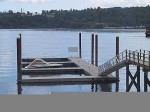
Example of a floating dock

To return to a docked boat on the BC coast after a few hours of sightseeing or shopping is sometimes a surprise for many tourists. The docks for the boats are built to float up and down on fixed pilings to accommodate the 21 foot tides (see photo left). To get onto the dock you walk up or down a ramp. A roller on the lower end rolls along the dock as the tide rises or falls. The top part of the ramp is hinged.

The tides change approximately every six hours, so if you left your boat and walked up the steep ramp to the topside dock at 10 AM (low tide) and came back at 2 PM (4 hours difference), the ramp would be almost horizontal (high tide). If you had lots of heavy groceries to move it was always a good idea to plan at what time of day you wanted to move them! Continue reading Tides

Mise Tales Thirteen


For an update on what a Mise Tale is then please see Mise Tales One.


More Lighthouse Wallpaper (Photos)

There are some beautiful scenes here to light up your computer Desktop. All are free to download in small to x-large sizes.


*******************************

Lighthouse Watch add-on for Firefox browser. A unique hand-drawn lighthouse scene for the Firefox browser, plus a desktop wallpaper as well. You must log-in to your Firefox Add-ons account to install and store it on your computer.


********************************** Continue reading Mise Tales Thirteen

Reprint – Presentation of a Lifetime Membership from Lightkeepers UCTE Local 20232 To Jim Abram

B.C. lightkeepers honour their champion

By Kristen DouglasCampbell River Mirror
Published: September 25, 2012 2:00 PM 
Updated: September 25, 2012 2:13 PM

[media url=”http://www.youtube.com/watch?v=JN7SZCsEERY” width=”400″ height=”350″]
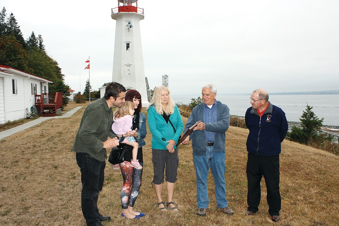
Strathcona Regional District director and former lightkeeper Jim Abram was honoured with a lifetime membership to the B.C. Lightkeepers Union Friday morning at the Cape Mudge Lighthouse on Quadra Island. Pictured from left, Abram’s son Jesse, daughter Melissa Abram, granddaughter Cleo Abram-Veloso, Abram’s wife Wendy, and Jim Abram, gather around to look at the commemorative plaque presented to Abram on behalf of the union.
 

Under cloudy skies, with the imposing Cape Mudge lighthouse looming in the background, former lightkeeper Jim Abram vowed to keep fighting for lightkeepers – the eyes and ears on the ocean. Continue reading Reprint – Presentation of a Lifetime Membership from Lightkeepers UCTE Local 20232 To Jim Abram

Reprint – Photo Gallery: Sutton Bridge Lighthouse Renovation Restores View Which Inspired Sir Peter Scott

Work continues on the Peter Scott Lighthouse near Sutton Bridge - owners Sue and Doug Hilton. Picture: Matthew Usher.

Photo gallery: Sutton Bridge lighthouse renovation restores view which inspired Sir Peter Scott

By DAISY WALLAGE Monday, July 30, 2012
– with permission from EDP24 online

With an endless sky, tantalising glimpses of the The Wash and wildfowl flying overhead, this stunning, sometimes lonely view was lost for decades as time took its toll on east bank lighthouse at Sutton Bridge.

Now, after months of loving restoration, visitors can finally climb to the top and bask in the uninterrupted views that so inspired the artist and conservation pioneer Sir Peter Scott more than 70 years ago.

The view from the top. Picture: Matthew Usher.

Owners Sue and Doug Hilton bought the lighthouse, on the mouth of the River Nene, in November 2010 and are steadily achieving their goal of opening a museum and visitor centre at the site as well as restoring the landmark tower itself.

New, locally crafted steel handrails on the lighthouse stairs will allow visitors to explore beyond Sir Peter’s living room to his second floor bedroom and the lamp room during a series of open weekends next month. Continue reading Reprint – Photo Gallery: Sutton Bridge Lighthouse Renovation Restores View Which Inspired Sir Peter Scott

Because John Coldwell Has An Inquiring Mind . . .

I just recently married a lovely Filipino lady here in the Philippines. The marriage was held on the beach at the Drill Shack Resort just outside Dumaguete, Negros Oriental, Philippines – actually closer to Dauin.

While in the Dumaguete area I met a Canadian friend, Brian Waddington, who used to live on a lighthouse near to mine at McInnes Island, BC. Brian wrote on August 27, 2012 on his Blogpost:

Because John Coldwell Has An Inquiring Mind I Will Publicly Embarrass Myself And Give Him And His Bride To Be This Story As A Wedding Present

John was the senior keeper at McInnes when I became the junior keeper at Ivory. He retired after 32 years as a keeper. He now runs a truly informative website about the life of a lighthouse keeper on the west coast of Canada. If you have ever wondered about the life of a keeper click on his name.

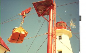
From left to right; workshop and senior keepers house, junior keeper house and garage, landing platform (red pole) control shed for hiline.

Ivory Island is a lighthouse on the north-west coast of Canada. Thirty plus years later I still dream of Ivory. To say it was a seminal time in my life is simply an understatement. Ivory was where I found the start of my spiritual path. Ivory is where the only child I have helped to conceive and father was created. I met my first two spiritual mentors while I was there. Ivory Island introduced me to the Thomas Crosby V which led me to Haisla village which allowed for the occasion where I met my future wife which is why I now live in the Philippines.

Some of my memories are sublime, some are joyous, some are mysterious but this one is just plain embarrassing. First you need a little background information. There are basically two ways to deliver anything to Ivory – helicopter or ship. Helicopter is quick and easy but not so good for heavy or bulky goods.

When goods are brought in by boat the cargo ship anchors, lowers the work boat and they bring the goods to where the ‘hook’ is lowered via the hi line. (look very closely at the first picture, just above the control shed you will see the hi-line running from the tall red pole down towards the water). Once the work boat crew secures the cargo to the hook it is picked up, wound in, lowered, unhooked and the hook is lowered again for the next load. Simple if everything works right not so simple when it doesn’t. This day it didn’t.

Perhaps I allowed the hook to pick up too much speed as gravity pulled it back to the water. Perhaps the stopper and the hook did not mate properly because a gust of wind moved the mechanism at a crucial point. In any case instead of doing what it was supposed to do the hook plunged into the water. Luckily this occurs with some frequency so the work boat was well clear of the rapidly descending hook. The other times this had happened I simply wound the hook in the way a fisherman reels in his line. The hook comes up sets itself properly and then I would again lower it so the work boat could hook up another load.

This time the hook snagged on something. With no way of knowing if it was snagged on a sunken log, a small easily moved rock or something worse I decided to apply a little more power and see what would happen. Bad decision! All of a sudden guy wires are snapping and the tower is starting to bend. No more cargo came ashore that day. What did come ashore a few days later was a five man work crew from Prince Rupert via helicopter with most of what was needed to fix the hi-line.

I say most… what they did not have was the bit for drilling the holes needed to do to put in the new anchoring pins. The drill bit was flown up from Victoria via helicopter. My bad choice was starting to get expensive. It got even more expensive after they had drilled four (if memory serves) five foot long 2 inch wide holes for the pins and then spent a day or two trying to hammer the 2 inch steel pins into the 2 inch holes.

For the next few days the work crew enjoyed a mini vacation while they waited for the proper sized drill bit. It is just possible that this had become such an embarrassment of errors to one and all concerned that they could not fire me without firing some bosses too. In any case I was and am ever so thankful I wasn’t fired.

There you are John my wedding gift to you, your future wife and your web site. Hope you can use it and it brings a smile to your face.

*******************************

Thanks Brian. We could not have had a better wedding gift!

Reprint – Lighthouse Homes

The story below is completely fictitious, but is very well done. From her idea the author has created a delightful lighthouse home! Maybe one of my readers can create another one which we can reprint here. How would you decorate your own fictitious lighthouse?

***************************************

Lighthouse Homes

published Thursday August 12, 2010

reprinted with permission from paperbean(AT)gmail(DOT)com

The storm sent the waves rolling and the rain pelting down… She banged and banged on the solid door, hoping for some respite from the high winds and slashing rains…

The door swung open to reveal a gruff man…

I remember the setting. I don’t remember the name of the book or the author… but I remember the setting. It’s probably been 10 years since I read that book (which I no longer have!).

The gruff man lived in a renovated/restored lighthouse.

What would my lighthouse be like?

Via kopishke - http://www.kopishke.org/

(Normally I eschew homes with stairs, preferring the single storied kind. But as we all know, lighthouses are/were built extra-solidly to weather storms, gales, winds… so I think I could live there!) Continue reading Reprint – Lighthouse Homes

DOTC Opens Bidding for P246-M Lighthouse Repair Project

This article appeared in the Business Mirror (Philippines). Take a look at why they are refurbishing old lighthouses:

Lighthouses serve as aids to navigation, working as visual guides to ports and harbors especially for fishermen and even for larger types of vessels already equipped with global positioning system.

Any more questions why Canada’s lighthouses cannot be retained?

The amount in the title is 246 million Philippine Pesos (PHP) or about $5,904,000 Canadian Dollars (CDN).

**********************************

Published in the Business Mirror (Philippines) on Thursday, 02 August 2012 20:17 Lenie Lectura / Reporter

“The DOTC is inviting providers to participate in the open and transparent bidding process for the P246 million procurement of aids to navigation equipment,” said the agency in a published bid notice. (The amount is 246 million Philippine Pesos (PHP) or about $5,904,000 Canadian Dollars (CDN).)

The government will procure in bulk the lighting and other component of this project to efficiently utilize its funds.

The civil works for the project will be bid out separately.

The DOTC and the PCG will repair and upgrade 194 lighthouses. Lighthouses serve as aids to navigation, working as visual guides to ports and harbors especially for fishermen and even for larger types of vessels already equipped with global positioning system.

In particular, the PCG listed lighthouses in the following areas where repairs and upgrade should be carried out at the soonest time possible. These are the lighthouses in Northern Luzon, National Capital Region, Southern Tagalog, Palawan, Bicol, Western and Eastern Visayas, Southwestern, Northern and Southeastern Mindanao. Continue reading DOTC Opens Bidding for P246-M Lighthouse Repair Project