Category Archives: Lighthouses

Descriptions of different BC lighthouses.

Reprint – The Lighthouses of British Columbia


In February 2012 I wrote an article on the seawater sample collecting from the BC lighthouses here My story discussed the duties and .trials a lightkeeper had while obtaining the samples. This story details the use of the information collected from a scientist’s point of view.

********************************

The Lighthouses of British Columbia

by Allan Roberts

Not only are British Columbia’s lighthouses picturesque, and important for navigational purposes, but they also collect oceanographic data! You can access sea surface temperature (SST) and surface salinity data at the following website:

www.pac.dfo-mpo.gc.ca/science/oceans/data-donnees/lighthouses-phares/index-eng.htm

This website also has photographs of the lighthouses. (See below.)

Figure 1. Race Rocks (48.180 N, 123.320 W). Photo credit: Fisheries and Oceans Canada. Photograph obtained from: http://www.pac.dfo-mpo.gc.ca/science/oceans/data-donnees/lighthouses-phares/index-eng.htm
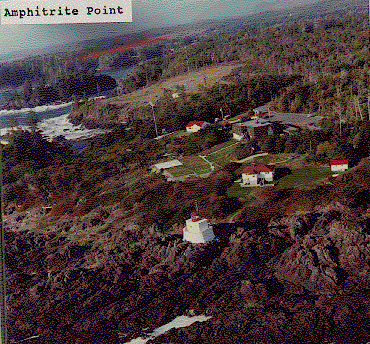
Figure 2. Amphitrite Point (48.550 N, 125.320 W). Photo credit: Fisheries and Oceans Canada. Photograph obtained from: www.pac.dfo-mpo.gc.ca/science/oceans/data-donnees/lighthouses-phares/index-eng.htm

I’ve compiled and plotted some of the data from the Race Rocks and Amphitrite Point lighthouses. Race Rocks (Figure 1) is near Victoria, while Amphitrite Point (Figure 2), on the west coast of Vancouver Island, is closer to Bamfield. The data plotted in Figure 3 are monthly averages for October, covering the years 1936 to 2011. The plot shows an evident contrast in SST and surface salinity between the two sites.
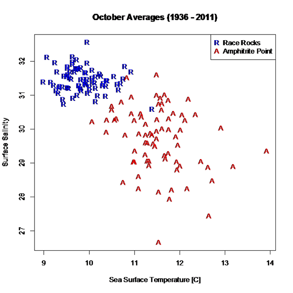
Figure 3. October averages for surface salinity plotted versus October averages for sea surface temperature. The data are from two different lighthouses: Race Rocks (48.180 N, 123.320 W) and Amphitrite Point (48.550 N, 125.320 W). Race Rocks is near Victoria, while Amphitrite Point is on the west coast of Vancouver Island. Data are not plotted for 1940 and 2007, because of missing values. Graphics produced with R (R Core Team, 2012). Data source: Fisheries and Oceans Canada, www.pac.dfo-mpo.gc.ca/science/oceans/data-donnees/lighthouses-phares/index-eng.htm (accessed Oct. 9, 2012).

A peculiarity of the lighthouse data is that they are not collected at the same time every day, as explained on the lighthouse data website: “Sampling occurs at or near the daytime high tide” (Fisheries and Oceans Canada, 2012).

If you want data for ocean bottom temperature and salinity (as opposed to surface temperature and salinity), such data are available through NEPTUNE Canada, and through the VENUS network (NEPTUNE Canada, 2012; VENUS, 2012).

Citations

Fisheries and Oceans Canada. 2012. Website. Accessed Oct., 9, 2012:http://www.pac.dfo-mpo.gc.ca/science/oceans/data-donnees/lighthouses-phares/index-eng.htm

NEPTUNE Canada, 2012. Website: www.neptunecanada.com

R Core Team, 2012. R: A language and environment for statistical computing. R Foundation for Statistical Computing, Vienna, Austria.

VENUS network, 2012. Website: www.venus.uvic.ca

Lightkeeper Retirement Homes

No, this does not refer to retirement homes such as you are imagining for senior citizens. This is a fictitious tale of what I imagine a lightkeeper might look for in a home when he retires. None of these homes are actually inhabited by a lighthouse keeper, as far as I know, but they appealed to me as a place where a keeper might like to retire.

Most keepers hate to leave their lighthouse homes at all, but sometimes, as in my case, retirement beckons too strongly and we give up the solitary life. Maybe we would move into . . . 

1. How about this one?

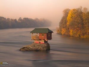
I saw this little dwelling and its location and immediately fell in love with it. It is isolated; it is near water; it even has a boat (note the kayak beneath the house). I still ride a bicycle, so why not paddling a kayak into old age? Perfect location for me.

The photograph is by Irene Becker for National Geographic Picture of the Day: A Tiny River House in Serbia. The website says:

A house in the middle of the Drina River near the town of Bajina Basta, Serbia. The Drina is a 346 km long river that forms much of the border between Bosnia and Herzegovina and Serbia. It is the longest tributary of the Sava River and the longest karst river in the Dinaric Alps.

i searched via Google Earth and finally found the location at latitude 43°59’3.73″N, Longitude 19°33’59.67″E (Google Earth KML file with several more photos of the house). Continue reading Lightkeeper Retirement Homes

Legoland Lighthouses

Legoland lighthouse

 Probably most of you have heard of Legoland Parks. Like the Disney parks, they seem to be all over the world, but the one I am going to speak about is Legoland Park California at 1 Legoland Drive, Carlsbad, California, 92008, USA 


Legoland Interactive Park Map

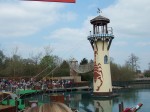
 I have mentioned Lego lighthouses as model kits before in posts, but in this park there are large lighthouse replicas – one of mention is in the New England Harbour area (see the interactive map at the left).


Continue reading Legoland Lighthouses

Chris Mills – Canadian Lighthouse Photographs


Canadian Lighthouse Photographs

New website is coming.
http://www3.ns.sympatico.ca/ketm/
is no longer online


Chris Mills
1121 Ketch Harbour Rd.
Ketch Harbour, Nova Scotia  B3V 1K7


British Columbia | Nova Scotia | Prince Edward Island | New Brunswick | Newfoundland

Chris Mills served as a lighthouse keeper for the Canadian Coast Guard on both the Atlantic and Pacific coasts.

He is currently co-chair of a committee which is recruiting Members of Parliament in support of a private members bill to protect lighthouses.  To see how you can help, visit this site:  Canada Needs a Lighthouse Protection Act.

Photographs and enlargements are for sale. Contact Chris Mills for price information.
All photographs and slides in the collection are identified, dated and signed.

Chris Mills is also author of the book on Nova Scotia lighthouses Lighthouse Legacies available from Amazon.ca


Sambro Island restoration project


BRITISH COLUMBIA

Some of these photos may be viewed at the Lighthouses of British Columbia site.

Green Island (1994, 1995) 250 colour photos, 70 colour slides in collection. All aspects of the station and island documented — aerial views, sea views, night views, details of light and lighthouse, lightkeepers, Coast Guard helicopters, surrounding islands and seascapes.


Langara Island (1994, 1996) 250 colour and 25 black and white photos, 180 colour slides in collection. All aspects of station documented — aerial views, night views, detailed views of 1913 First Order Fresnel Lens (manufactured by Chance Brothers), light tower and lantern, lightkeepers, dwellings, interior of engine room, old cabin on island, face carved in tree, shoreline views, lightkeeper’s goats, stormy seas.


Triple Island (1994) 24 colour photos in collection. Aerial views, third order Fresnel lens, lightkeeper, detailed views of lighthouse structure, interior of workshop and engine room.


Bonilla Island (1994) 250 colour photos in collection. Many aspects of station — aerial views, sea views, night views, shoreline views (including Japanese glass fishing floats), lightkeepers, dwellings, engine room interior, light tower. (NOTE: this collection will be expanded during Sept/Oct 1996)


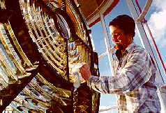
Boat Bluff (1994-1996) 160 colour photos in collection. All aspects of station — aerial views, sea views, night views, details of light tower, fog horns , engine room, main light (including views of keeper inspecting light at night, inspection of light and bulbs during day), views of station and mountains from 1000 foot hill across the channel from lightstation, snow views, old hand fog horn, three modern plastic lenses, sunrise views, surrounding bays and inlets, Santa and Mrs. Claus visit 1994. (NOTE: Available as of Dec. 1996 — selection of a further 200 colour and b&w prints taken during August 1996, including Coast Guard ship and work crews supplying station.)


Ivory Island (1994-1996) 600+ colour and 36 black and white photos, 100 colour slides in collection. All aspects of the lightstation — 30 aerial views, sea views, night views, lighthouse, keepers, dwellings inside and out, engine room, main light, surrounding area, beaches, salmon fishing, snow, totem poles, artist and photographer at work at the lightstation, Coast Guard helicopters, sunsets, shoreline and forest, various tidal life (sea stars, crabs, etc.), local minor beacon lights, 25th annual Santa and Mrs. Claus visit December 1995.


McInnes Island (1994, 1995) 48 colour photos, 22 colour slides in collection. Aerial views, lighthouse structure, radio room, keeper, detail of lantern and main light, large thunder cloud formations.


Dryad Point (1995) 32 colour photos in collection. Aerial views, light tower, main light, keeper and daughter, keeper and main light, dwelling. (NOTE: This collection will be expanded during 1997)


Addenbroke Island (1994) 14 colour photos in collection. Aerial views.


Egg Island (1994) 10 colour photos in collection. Aerial views.


Pine Island (1994) 3 colour photos in collection. Aerial views.


Scarlett Point (1994) 2 colour photos. Aerial views.


Point Atkinson (1994) 14 black and white photos in collection. Light tower, keeper and main light, station dwellings and exterior of radio/engine room.


Brockton Point (1994) 5 black and white photos in collection. Light tower.


Porlier Pass (1994) 32 colour photos in collection. Two light towers (Porlier is a range light station), main lights, boat and boathouse, lightkeeper, dwelling, interior engine room and fog horn building, Coast Guard hovercraft. (NOTE: The old front range light was demolished Feb. 1996 and replaced by a fibreglass tower and the lighthouse was automated shortly after.)


Fisgard (1994) 6 colour, 2 black and white photos in collection. Light tower and detail of gothic style window in old keepers dwelling.


Sheringham Point (1994, 1995) 20 colour photos in collection. Light tower, abandoned dwelling, sunset, old Fresnel lens at local museum.


Amphitrite Point (1995) 9 colour slides in collection (prints available). Lighthouse structure, old keepers dwelling.


Lennard Island (1995) 52 colour photos, 25 colour slides in collection. Traveling to island by boat, keeper in boat, keeper in lighthouse, keeper and wife on station grounds, dwellings, radio room, engine room, details of two fog horn systems, including traditional diaphone horn taken out of service Oct. 1995, light tower, station grounds.


Cape Scott (1996) 23 colour photos in collection. Aerial views.

NOVA SCOTIA

Some of these photos may be viewed at the Nova Scotia Lighthouse Preservation Society site.

Baccaro Point
Bear River
Beaver Island
Black Rock Point
 (new lighthouse)

Black Rock Point (old lighthouse)
Boar’s Head
Brier Island
Cape Forchu
Cape George
Cape Sable
Chebucto Head
Fort Point
 (LaHave River)

Fort Point (Liverpool)
Fourchu Head
Gabarus
George’s Island
Grand Passage
Hampton
 (Chute Cove)

Horton Bluff
Jerome Pont
Louisbourg
Low Point
Maugher’s Beach
Medway Head
Peggy’s Cove
Point Aconi
Port Greville
 (old light, now at Canadian Coast Guard College, Point Edward, N.S.)

Port Medway
Prim Point
Rouse Point
Sable Island
 (east light)

Sable Island (west light)
Sambro Island
Scatarie Island
Schafner Point
Seal Island
Sydney Range
 (front light)

Sydney Range (rear light)
Western Head
Battery Point
Betty’s Island
Canso Locks
Cross Island
 (comprehensive collection including automation day)

Eddy Point
Mosher’s Island
Seal Island
 (comprehensive collection)

Seal Island Lighthouse Museum

PRINCE EDWARD ISLAND

Blockhouse Point
Borden Range
 (front light)

Borden Range (rear light)
Cape Bear
Cape Tryon
Brighton Beach Range
 (front light)

Brighton Beach Range (rear light)
East Point
Murray Harbour Range
 (front light)

New London Range (rear light)
North Rustico
Panmure Island
Point Prim
Souris East
Summerside Range
 (front light)

Summerside Range (rear light)
Woods Islands
Woods Islands Range
 (front light)

Woods Islands Range (rear light)

NEW BRUNSWICK

Cape Spencer
Cape Tormentine
Fish Fluke Point
 (Grand Harbour)

Gannet Rock (comprehensive collection: 700+ prints and slides)
Great Duck Island
East Quoddy
 (Head Harbour)

Letite
Long Eddy
Long Point
Machias Seal Island
 (comprehensive collection)

Mulholland Point
Southwest Head
Swallowtail

NEWFOUNDLAND

Cape Anguille
Cape Ray
Cape Saint Francis
 (dwelling only)

Cape Saint Mary’s
Cape Spear
Lobster Cove Head
Rose Blanche
 (old stone lighthouse)

Northern Lights at the Lighthouse


In my twenty-five (25) years on McInnes Island one of the most spectacular sights in the winter was the Northern Lights display (aurora borealis1) in the northern night time sky. Absolutely beautiful!

This was brought to mind the other day when I saw this October 10, 2012 article online Image: Aurora Dips South Across Canada

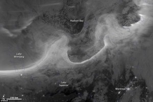
The aurora borealis was photographed from space over Montreal and Lake Superior on Oct. 08, 2012. CREDIT: NASA Earth Observatory

When a powerful solar flare, known as a coronal mass ejection, hit Earth’s magnetic field on Oct. 8, people living in North America’s northern latitudes were treated to a spectacular light show.

This visible light image from the Suomi National Polar-orbiting Partnership (Suomi NPP) satellite shows the northern lights swirling across Canada’s Quebec and Ontario provinces. The city lights of Montreal also shine in the bottom of the image.

Source:Image: Aurora Dips South Across Canada by   www.livescience.com Continue reading Northern Lights at the Lighthouse

Tides

photo Paul Kurbis

One of the reasons for the establishment of a lighthouse is to mark the dangers from the effect of extreme tides (low and high) on surrounding lands, islands, waterways, and beaches. 

Look at the photo on the left of my old lighthouse at McInnes Island at low tide (click for a larger version). We can tell it is low tide because the kelp is exposed on the rocks, and the high tide mark on the rocks is marked by a dirty black line. Here on the Pacific Coast of Canada, the tides come in and go out twice a day, and the range is between seventeen (17) and twenty-one (21) feet (6 to 7 meters)!

Note the small rock at dead center, bottom of the photo. At high tide that would be covered and become a menace to navigation. In this case this is not a marked shipping channel so no marker is necessary. The reason for the lighthouse (visible on the left of the large island) is that it was listed as a landfall light. A marker for ships coming in from the Pacific Ocean to the British Columbia coastline, and also a marker for the entrance to Milbanke Sound. It really doesn’t mark the island as dangerous; just an indicator of a mariner’s location on the ocean.

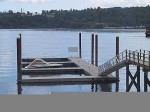
Example of a floating dock

To return to a docked boat on the BC coast after a few hours of sightseeing or shopping is sometimes a surprise for many tourists. The docks for the boats are built to float up and down on fixed pilings to accommodate the 21 foot tides (see photo left). To get onto the dock you walk up or down a ramp. A roller on the lower end rolls along the dock as the tide rises or falls. The top part of the ramp is hinged.

The tides change approximately every six hours, so if you left your boat and walked up the steep ramp to the topside dock at 10 AM (low tide) and came back at 2 PM (4 hours difference), the ramp would be almost horizontal (high tide). If you had lots of heavy groceries to move it was always a good idea to plan at what time of day you wanted to move them! Continue reading Tides

Mise Tales Thirteen


For an update on what a Mise Tale is then please see Mise Tales One.


More Lighthouse Wallpaper (Photos)

There are some beautiful scenes here to light up your computer Desktop. All are free to download in small to x-large sizes.


*******************************

Lighthouse Watch add-on for Firefox browser. A unique hand-drawn lighthouse scene for the Firefox browser, plus a desktop wallpaper as well. You must log-in to your Firefox Add-ons account to install and store it on your computer.


********************************** Continue reading Mise Tales Thirteen

Mise Tales Twelve


For an update on what a Mise Tale is then please see Mise Tales One.

Do You Want to Buy a Foghorn?

Aberdeen’s Torry Coo on the market for £5,000
Buyers lining up for foghorn

Published: 28/09/2012 Evening Express

A famous foghorn in Aberdeen has sparked a bidding war between prospective buyers desperate to own a piece of Scottish history.

And property agents revealed several offers made for the much-loved Torry Coo in Aberdeen were “well in excess” of the asking price.

The Northern Lighthouse Board put the 110-year-old horn and store building on the market in July with a price tag of £5,000, but several mystery bidders want to get their hands on the Category A listed structure. Continue reading Mise Tales Twelve

Three Skeleton Key – A Lighthouse Play


Three Skeleton Key is a one act play I have never heard about before today. It was written as a short story by George G. Toudouze and was first published in 1937 in English.


This is a short story about three men who operate a lighthouse miles offshore of the South American coast.  They love their job untill one day a strange ship arrives.  Suddenly they are unsure if they will survive to see the next day.

Setting

This story is set on a “key” or small island several miles offshore of French Guianna in the early 1900s.  Lighthouse operators whould spend months at a time isolated out on their tiny islands without any contact with the rest of the world. Continue reading Three Skeleton Key – A Lighthouse Play

Animals at Lighthouses


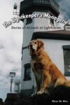
Lightkeeper's Menagerie
Lightkeeper’s Menagerie

In November 2011 I made a post about a book by Elinor De Wire called The Lightkeeper’s Menagerie. This was a book about stories of animals at lighthouses. Later, in 2012 I received a nice email from Elinor and an offer to send me a copy of the book. The book arrived a while ago and I have yet to delve into it’s 328 pages (I will soon Elinor!), but I came across a couple of photos that brought to mind my stories of animals on lighthouses.

I did write about Cougars on the Doorstep but this post is referring to mostly my pets who lived on the lighthouses where I served.

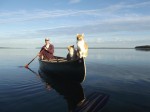
cats on a canoe
cats on a canoe

The picture on the left shows two cats on the bow of a canoe and I immediately thought of our first Siamese cat called

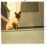
Tipsy at Pulteney
Tipsy at Pulteney

Tipsy, because she used to drink beer!. Tipsy travelled to our first lighthouse at Pulteney Point, but before we moved to the lighthouse we used to take our canoe out on the ocean.

Tipsy always wanted to come – in the car, in the canoe, on walks, into bed – we could never leave her behind. So, off into the ocean she went with us. Upon our return to shore she would jump from the bow, about 10 feet from the shore, and swim to the beach! She was not afraid of water as most cats are. Tipsy loved the lighthouse. Lots more to do than being stuck in an apartment!

**********************************

Tricia grins
Tricia grins

At Pulteney Point we decided we needed a dog as well. Well, one of my favourites was the Dalmation so our next trip out we purchased a Dalmation pup. Tricia was a Continue reading Animals at Lighthouses