My website here is about British Columbia (BC) lighthouses and the environment surrounding them.
Just recently a good friend sent me an email to a website called Picture BC, a delightful photo and video tour of the province of British Columbia, Canada – as beautiful now as when it was created in 2008.
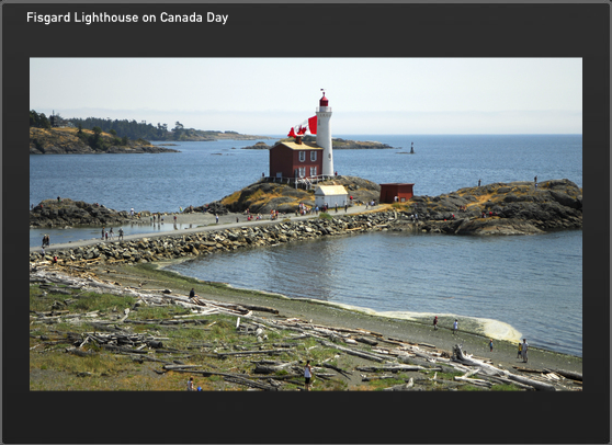
Picture BC photo
According to the site:
Picture BC is an initiative of the Union of British Columbia Municipalities (UBCM), an organization representing the communities participating in this website. The idea and support for Picture BC came from the Province of British Columbia.
The site contains a five (5) minute video tour of the whole of BC (above) which is very well done. If you have never been to BC, you will want to come and visit after seeing this video. If you plan on coming, this is where the lighthouses are. The video shows two or three lighthouses near the end of the clip but there are many more on the BC coast.
There are interactive maps of the regions of BC with links to most cities in the province.
There are also some beautiful photos of major tourist destinations in BC, as well as scenes which cannot be seen unless you take a helicopter or plane ride.
The website is done with Adobe Flash player so it is a bit tricky to manouever around, but have patience – it is worth it!
STAND, presented by Quiksilver Waterman, will take viewers on a journey through the waters of B.C.’s west coast. Through the stories of an aboriginal high school class building their own stand-up paddleboards as a form of protest, the efforts of expedition stand-up paddler Norm Hann, and the powerful surfing of iconic west coast native Raph Bruhwiler, the diversity of people, landscape and wildlife that would be affected by an oil spill
will be articulated. STAND will take you to the core of the issue and unfurl the soul of B.C.’s west coast one paddle stroke at a time.
Cedar Standup Paddleboard
The crew is currently raising funds through the popular crowd-sourcing platform IndieGoGo, in order to complete post-production and bring this story into the mainstream consciousness. You can become a champion of the Great Bear and help protect our precious coastlines by donating to the project and in return receive some great rewards.
October 23, 2012 – “STAND” the new film from b4apres Media in association with Dendrite Studios will take you into the heart of the largest temperate rainforest on the planet—the Great Bear in British Columbia, Canada. Hung on the skeleton of a good ol’ fashioned adventure undertaken by a group of surfers, the potential effects of introducing super tankers to these pristine waters will be articulated. As the crew moves through this remote region under their own power, the landscape will be unfurled one paddle stroke at a time and punctuated by the faces and fears of the First Nation people who call this garden of Eden their home. Not just an efficient mode of transport, a stand up paddleboard expedition will be symbolic of “standing up” to preserve this last bastion of rainforest. Captured in cinematic High Definition, the film will bring the Enbridge Pipeline debate into the collective consciousness in a way that will have you fishing in your basement for that old fluorescent wetsuit.
Quiksilver Waterman has signed on as the presenting sponsor for STAND. Since the crew had the concept for the film last year, they have been searching for a partner to support the project. That partner, however, needed to be the right fit and believe in the cause, in protecting British Columbia’s West Coast. Thankfully Quiksilver Waterman along with the Quiksilver Foundation 1 share a strong commitment to the environment.
Norm Hann and Raph Bruhwhiler are both Quiksilver ambassadors and agreed to join the project from the beginning. Both are true waterman and dedicated to the protection of the waters that they derive so much enjoyment from as well as the occasional seafood platter. Having Quiksilver Waterman involved makes the perfect trilogy and will allows the filmmakers to illuminate the stories, adventures and landscapes that abound in this truly magic part of the world.
Long protected by the 1972 Trudeau government moratorium on crude oil tankers plying British Columbia’s north coast, these waters are now facing the risk of oil spill. Potentially, 225 Very Large Crude Carriers (VLCC) per year would each transport approximately 2 million barrells of oil through the Great Bear Rainforest. In context, today’s supertankers carry ten times the volume of the Exxon Valdez oil spill. Put simply, the pristine marine and terrestrial ecosystems as well as the people of the Great Bear would likely not recover from such an incident.
This issue is perhaps the most important environmental issue in B.C. history. Whats more, a catastrophic oil spill could reach beyond borders and impact much of the Pacific North West coastline.
Visit the official Dogwood Initiative Website to learn more and find out how to get involved.
1 For years, Quiksilver and Roxy have been actively engaged in charitable activities, both locally and globally. Quiksilver recognises the concept of corporate social responsibility and benevolence. We want our philanthropic work to have impact beyond what we do as one company and believe that we can do this by coordinating the support of other organizations and individuals. The Quiksilver Foundation was formed to bring all of Quiksilver’s charitable giving under one umbrella. The Foundation commenced its activities as a private foundation in October of 2004.
With offices in Europe, Australia and America, Quiksilver has the capability of reaching people worldwide. Quiksilver has the vision of making a difference to community and environment through the Quiksilver Foundation.
The Quiksilver Foundation is a non-profit organization committed to benefiting and enhancing the quality of life for communities of boardriders across the world by supporting environmental, educational, health and youth-related projects.
The Quiksilver Foundation has a commitment to improve the quality of all our lives.
We desire to benefit:
Local Communities, including schools, local charities through support and outreach programs;
Major special projects and organizations sharing our focus on children, education, science, oceans and the environment.
I received the following email the other day promoting an article on a friend’s website:
The freighter Vanlene ran up on the rocks on Austin Island in the Broken Group islands on March 14, 1972. She was carrying 300 Dodge Colt automobiles while enroute to Vancouver BC from Japan. The crew was rescued and taken to Port Alberni. How she ended up on the rocks is still a matter of conjecture but it appears that the Master simply did not know where he was at the time of impact (he thought he was off of the coast of Washington) and his navigational aids were inoperable. See the article at Nauticapedia.
On one of our beachcombing trips Roger Mogg and I headed up this narrow deep inlet on the East side of Price Island, just a few kilometres from McInnes Island Lighthouse. (see interactive map above – red marker is McInnes Island; Price Island is NE a bit and labelled as such) Continue reading Death on Price Island→
I came across this article that shows the life on an Australian lighthouse starting in 1971. A wee bit different than Canada I must say.
What got my attention were the requirements for a lighthouse keeper:
The job requirements of a lighthouse keeper were a car licence, an ability to climb to heights and an ability to get along with the other lighthouse keeper . . .
The article is worth reading to illustrate the differences between Canadian and Australian lights (wildlife, for one), plus, on the page is a reference and a link to an ABC (Australian Broadcasting Corporation) website which is exploring some of Australia’s iconic lighthouses.
This new site is called Shining a Light and is an excellent documentary on some of Australia’s lighthouses. The map above shows the lighthouses mentioned.
Back on November 21st of this year I wrote What Ship Is That? to show people how to find out the location of their favourite ship as seen from a lighthouse, a home overlooking the water, or a sightseer on a hilltop. I would have loved to have had something like that on the lighthouses when I was there.
One other thing that always got our attention, especially at night, was the flickering lights of aircraft passing overhead. Many a time I wondered where the plane was coming from, or where it was going. You see, at the time, we ran an aircraft non-directional radio beacon which the planes used for navigation. It was more a check than actual navigation, but they did use it because they passed right over the top of us on the lighthouse, albeit at 30,000 feet! Continue reading What Plane Is That?→
Have you ever sat on a lighthouse, or a wharf, or a high hill and seen a ship in the distance? No radio, too far for binoculars, bad eyesight – “What ship is that?” you wonder.
Wonder no more! The Internet is full of ship tracking programs. Select one to suit your needs. You can find any ship that is required to report, anywhere in the world. I doubt you will find drug smugglers, or such like that. Let me know if you do!
The programs are listed in the order I found them – not in best to worst, etc. You take your pick. Try them all. Let the readers know in the comments section which program you found the best.
For information on how this works and was developed, see this ESRI website.
1. sailwx.infoThis online program is very interesting. It has information on:
One of the arguments for destaffing the lighthouses in British Columbia (BC), Canada is that they are no longer needed because all vessels have the Global Positioning System (GPS). Canadian mariners must move into the 21st Century they say!
Have you ever looked at British Columbia? The size of British Columbia?
Note the three roads to Vancouver, Bella Bella, and Prince Rupert
British Columbia is the westernmost province of Canada, bordered by the Pacific Ocean. With an area of 944,735 square kilometers (364,764 sq mi) it is Canada’s third-largest province. The province itself is eleven times the size of Austria, where I live; nearly four times the size of Great Britain, two and one-half times larger than Japan and larger than every U.S. state except Alaska. 1 Continue reading Why We Need MORE Lighthouses in British Columbia→
Iconic lighthouses lead the way to The Bahamas from the Caribeean News Now
Map of BahamasNASSAU, Bahamas — Sailors prized them. Pirates hated them. Today they are romantic symbols of adventure, travel and solitude. Lighthouses still stand watch throughout The Islands of The Bahamas and The Bahamas Lighthouse Preservation Society safeguards three of the world’s few remaining kerosene-burning, hand-wound lighthouses.
Built in 1863, the famed Hope Town Lighthouse on Elbow Cay, Abaco still guides boats and ships today. Boating remains a way of life in the Abacos and throughout The Bahamas and the lighthouses are treasured even if modern captains navigate by satellite. Continue reading Travel – Bahamas Has Two Dozen Lighthouses!→