Category Archives: On The Job

An Island Dispute of our Own

An island dispute of our own
Posted By Joshua Keating  Wednesday, November 28, 2012 – 11:36 AM

It’s not quite the Senkakus, but Stephen Kelly highlights a long-festering territorial dispute between the United States and Canada:

Machias Seal Island is a 20-acre, treeless lump that sits nearly equidistant from Maine and New Brunswick. It, and the even smaller North Rock, lie in what local lobstermen call the gray zone, a 277-square-mile area of overlapping American and Canadian maritime claims.

The disagreement dates back to the 1783 Treaty of Paris that ended the Revolutionary War. The treaty assigned to the newly independent 13 colonies all islands within 20 leagues — about 70 miles — of the American shore. Since Machias Seal Island sits less than 10 miles from Maine, the American position has been that it is clearly United States soil.

But the treaty also excluded any island that had ever been part of Nova Scotia, and Canadians have pointed to a 17th-century British land grant they say proves the island was indeed part of that province, whose western portion became New Brunswick in the late 18th century.

Perhaps more important to the Canadian case, the British built a lighthouse on Machias Seal Island in 1832, which has been staffed ever since. Even today, two lighthouse keepers are regularly flown to the island by helicopter for 28-day shifts to operate a light — even though, like every other lighthouse in Canada, it is automated. – Opinion Pages – NY Times

[private]

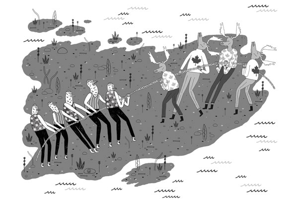
The New York Times Opinion pages Good Neighbors, Bad Border Cartoon: John Malta
By STEPHEN R. KELLY   Published: November 26, 2012

AT a time when territorial disputes over uninhabited outcrops in the East China Sea have led to smashed cars and skulls in China, a similar, if less dramatic, dispute over two remote rocks in the Gulf of Maine smolders between the United States and Canada.

Machias Seal Island and nearby North Rock are the only pieces of land that the two countries both claim after more than 230 years of vigorous and sometimes violent border-making between them.

Except for the occasional jousting of lobster boats, this boundary dispute floats far below the surface of public or official attention, no doubt reflecting the apparent lack of valuable natural resources and a reluctance to cede territory, no matter how small.

But if we are unlikely to resort to arms anytime soon, the clashes in Asia have shown how seemingly minor border disputes can suddenly stoke regional and nationalistic tensions. Our relaxed attitude toward these remote rocks may well be a mistake.

While the United States and Canada have other maritime boundary disputes along their 5,525-mile border, the world’s longest, this is the only one left that involves actual chunks of land.

Machias Seal Island is a 20-acre, treeless lump that sits nearly equidistant from Maine and New Brunswick. It, and the even smaller North Rock, lie in what local lobstermen call the gray zone, a 277-square-mile area of overlapping American and Canadian maritime claims.

The disagreement dates back to the 1783 Treaty of Paris that ended the Revolutionary War. The treaty assigned to the newly independent 13 colonies all islands within 20 leagues — about 70 miles — of the American shore. Since Machias Seal Island sits less than 10 miles from Maine, the American position has been that it is clearly United States soil.

But the treaty also excluded any island that had ever been part of Nova Scotia, and Canadians have pointed to a 17th-century British land grant they say proves the island was indeed part of that province, whose western portion became New Brunswick in the late 18th century.

Perhaps more important to the Canadian case, the British built a lighthouse on Machias Seal Island in 1832, which has been staffed ever since. Even today, two lighthouse keepers are regularly flown to the island by helicopter for 28-day shifts to operate a light — even though, like every other lighthouse in Canada, it is automated.

While abundant legal arguments surround Machias Seal Island, natural resources are far less evident. No oil or natural gas has been discovered in the area, nor has it had any strategic significance since it served as a lookout for German U-boats during World War I.

Tour boats from Maine and New Brunswick carry strictly limited numbers of bird watchers to the island to see nesting Atlantic puffins. And the surrounding waters contain lobsters that, thanks to different regulatory schemes and overlapping claims, have occasionally sparked clashes between Maine and New Brunswick lobstermen, although a bumper lobster crop this summer has slackened demand for gray zone crustaceans.

But the lack of hydrocarbons and the current lobster glut make this an ideal time to color in the gray zone.

The United States and Canada settled all their other maritime differences in the Gulf of Maine in 1984 by submitting their claims to the International Court of Justice for arbitration. They could have included the gray zone in that case, but did not. The Canadians had refused an earlier American arbitration proposal by saying their case was so strong that agreeing to arbitration would bring their title into question.

This attitude calls for re-examination. The fact that so little in the way of resources appears to be at stake, far from justifying the status quo, should be the main reason for resolving the issue. And for those concerned about blowback from “giving away” territory, letting the international court decide the case provides the most political cover.

As China and Japan can attest, border disputes do not go away; they fester. And when other factors push them back to the surface — the discovery of valuable resources, an assertion of national pride, a mishap at sea — the stakes can suddenly rise to a point where easy solutions become impossible.

Before that happens, we should put this last land dispute behind us, and earn our reputation for running the longest peaceful border in the world.

Stephen R. Kelly is the associate director of the Center for Canadian Studies at Duke University and a retired American diplomat who served twice in Canada.

A version of this op-ed appeared in print on November 27, 2012, on page A31 of the New York edition with the headline: Good Neighbors, Bad Border.

[/private]

[private] An island dispute of our ownPosted By Joshua Keating  Wednesday, November 28, 2012 – 11:36 AM  
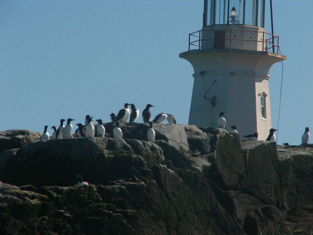
It’s not quite the Senkakus, but Stephen Kelly highlights a long-festering territorial dispute between the United States and Canada:

Machias Seal Island is a 20-acre, treeless lump that sits nearly equidistant from Maine and New Brunswick. It, and the even smaller North Rock, lie in what local lobstermen call the gray zone, a 277-square-mile area of overlapping American and Canadian maritime claims.

The disagreement dates back to the 1783 Treaty of Paris that ended the Revolutionary War. The treaty assigned to the newly independent 13 colonies all islands within 20 leagues — about 70 miles — of the American shore. Since Machias Seal Island sits less than 10 miles from Maine, the American position has been that it is clearly United States soil.

But the treaty also excluded any island that had ever been part of Nova Scotia, and Canadians have pointed to a 17th-century British land grant they say proves the island was indeed part of that province, whose western portion became New Brunswick in the late 18th century.

Perhaps more important to the Canadian case, the British built a lighthouse on Machias Seal Island in 1832, which has been staffed ever since. Even today, two lighthouse keepers are regularly flown to the island by helicopter for 28-day shifts to operate a light — even though, like every other lighthouse in Canada, it is automated.

Kelly reasonably suspects that the lack of natural resources in the region have made both sides reluctant to rock the boat by submitting their claims to the International Court of Justice for arbitration, as they have with other disputes. There’s simply nothing there worth the risk of losing the case and having to explain to voters why you “gave away” U.S. or Canadian territory. In any case, from the photos on Flickr it looks like the Canadian government has staked a pretty permanent claim to the island, so this one may be de facto settled.

Machias is the only U.S.-Canadian border conflict that involves land, but the sea border is disputed in a few places. Here’s Wikipedia’s list:

  • Strait of Juan de Fuca 48°17?58?N 124°02?58?W (Washington /British Columbia) The middle-water line is the boundary, but the governments of both Canada and British Columbia disagree and support two differing boundary definitions that would extend the line into the Pacific Ocean to provide a more definite Exclusive Economic Zone (EEZ) boundary.
  • Dixon Entrance 54°22?N 132°20?W (Alaska / British Columbia) is wholly administered by Canada as part of its territorial waters, but the US supports a middle-water line boundary, thereby providing the US more maritime waters. Canada claims that a 1903 treaty demarcation is the international maritime boundary, while the United States holds that the maritime boundary is an equidistant line between the islands that form the Dixon Entrance, extending as far east as the middle-water line with Hecate Strait to the south and Clarence Strait to the north.[2]
  • Yukon–Alaska disputeBeaufort Sea 72°01?40?N 137°02?30?W(Alaska / Yukon) Canada supports an extension into the sea of the land boundary between Yukon and Alaska. The US does not, but instead supports an extended sea boundary into the Canadian portion of the Beaufort Sea. Such a demarcation means that a minor portion of Northwest Territories EEZ in the polar region is claimed by Alaska, because the EEZ boundary between Northwest Territories and Yukon follows a straight north-south line into the sea. US claims would create a triangular shaped EEZ for Yukon. This is mainly an Alaska-Yukon dispute.
  • Northwest Passage; Canada claims the passage as part of its “internal waters” belonging to Canada, while the United States regards it as an “international strait” (a strait accommodating open international traffic).

The last two might get a bit more controversial as resource competition in the rapidly melting Arctic heats up.

[/private]
Visiting the BC Coast Lighthouses

Do you want to visit some of British Columbia lighthouses? A lot of them are isolated, but there are a few that tourists can easily see. Some of these are manned; some are automated.

One of the best websites for finding the location of the  lighthouses is Ron Ammundsen’s Lighthouses of British Columbia website. On the opening page he has maps of manned/staffed and unmanned lighthouses and their locations. This will show you what is available, and where they are located. To find photos and information on the chosen lighthouses check out Google.


One of the main items you will require is a place to stay. When flying to British Columbia via International Airlines (from another country) your point of entry would be Vancouver International Airport (YVR). From there you have a variety of ways to accommodate yourself – from hotel, motel, bed and breakfast, camp site, hostel, inn, resort, etc. Select from the list on the Hello BC website. Enter your dates, town, and preference, and select a place to stay. Really easy website to find your way around.

The next thing after a room for the night, is a place to eat. Canada is well-known for its diversity in the culinary arts, and British Columbia is no exception. The easiest way is to introduce you to a special webpage called Dining, again from Hello BC. This is an interactive menu connected to a BC map. Pick what type of food you want, where you want to eat, and wait for the results. It is well organized and easy to use.

The choice is amazing! Your selection may be saved as a PDF file for reference. Pick your town, pick your food and grab a cab to good dining. The nice thing is you can look on the map to see if a location is near your place of residence for any place in BC. The map (left) shows the 538 results from just selecting West Coast. Each red flag is a city with multiple locations in each. Each result will give you location, telephone number and website if available. A very comprehensive help page.

Fisgard Lighthouse

Before you come you should decide where you want to go, and what lighthouses you want to see. Most of the available lighthouses will be seen in and around the cities of Vancouver, and Victoria, BC. Others are visible from the ferries, and up and down Vancouver Island. On the Hello BC website on the Things To Do page there are no exact listings for lighthouses but if you type lighthouse in the search box (upper right) you will get a page of lighthouse listings, things lighthouse, resorts near lighthouses, etc. With the map from the website on Lighthouses of British Columbia you can then sort out where you want to go and which lighthouse you may wish to visit..

If you want to get off the beaten track, you can fly into many places or take ferries, hike in, or even rent a local water taxi or fish boat. The opportunities are unlimited depending on your time and finances. On the Hello BC webpage is also a section on Transportation and Maps listing many services available in BC.

Take your time, talk to other tourists, and if you have any questions, maybe I or other readers can help you out. They don’t call it Beautiful BC for nothing. Enjoy!

******************************

To help you enjoy the coast more, it might be helpful to read up on a few of the things you might find at the shoreline. A great website for this is Vic High Marine. Check out the information on all things you might stumble across, or see on your trip.

Any more good advice out there? Please send it on and I will post it.

Reprint – The Lighthouses of British Columbia


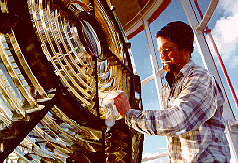
In February 2012 I wrote an article on the seawater sample collecting from the BC lighthouses here My story discussed the duties and .trials a lightkeeper had while obtaining the samples. This story details the use of the information collected from a scientist’s point of view.

********************************

The Lighthouses of British Columbia

by Allan Roberts

Not only are British Columbia’s lighthouses picturesque, and important for navigational purposes, but they also collect oceanographic data! You can access sea surface temperature (SST) and surface salinity data at the following website:

www.pac.dfo-mpo.gc.ca/science/oceans/data-donnees/lighthouses-phares/index-eng.htm

This website also has photographs of the lighthouses. (See below.)

Figure 1. Race Rocks (48.180 N, 123.320 W). Photo credit: Fisheries and Oceans Canada. Photograph obtained from: http://www.pac.dfo-mpo.gc.ca/science/oceans/data-donnees/lighthouses-phares/index-eng.htm

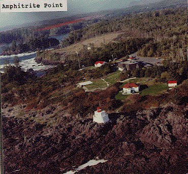
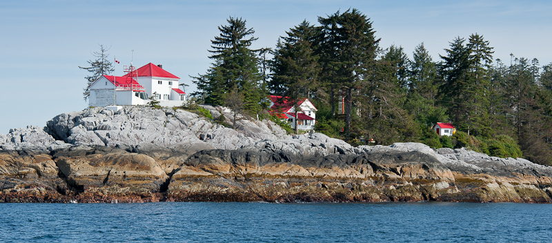
Figure 2. Amphitrite Point (48.550 N, 125.320 W). Photo credit: Fisheries and Oceans Canada. Photograph obtained from: www.pac.dfo-mpo.gc.ca/science/oceans/data-donnees/lighthouses-phares/index-eng.htm

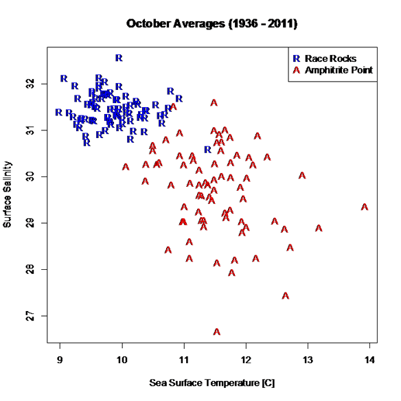
I’ve compiled and plotted some of the data from the Race Rocks and Amphitrite Point lighthouses. Race Rocks (Figure 1) is near Victoria, while Amphitrite Point (Figure 2), on the west coast of Vancouver Island, is closer to Bamfield. The data plotted in Figure 3 are monthly averages for October, covering the years 1936 to 2011. The plot shows an evident contrast in SST and surface salinity between the two sites.

Figure 3. October averages for surface salinity plotted versus October averages for sea surface temperature. The data are from two different lighthouses: Race Rocks (48.180 N, 123.320 W) and Amphitrite Point (48.550 N, 125.320 W). Race Rocks is near Victoria, while Amphitrite Point is on the west coast of Vancouver Island. Data are not plotted for 1940 and 2007, because of missing values. Graphics produced with R (R Core Team, 2012). Data source: Fisheries and Oceans Canada, www.pac.dfo-mpo.gc.ca/science/oceans/data-donnees/lighthouses-phares/index-eng.htm (accessed Oct. 9, 2012).

A peculiarity of the lighthouse data is that they are not collected at the same time every day, as explained on the lighthouse data website: “Sampling occurs at or near the daytime high tide” (Fisheries and Oceans Canada, 2012).

If you want data for ocean bottom temperature and salinity (as opposed to surface temperature and salinity), such data are available through NEPTUNE Canada, and through the VENUS network (NEPTUNE Canada, 2012; VENUS, 2012).

Citations

Fisheries and Oceans Canada. 2012. Website. Accessed Oct., 9, 2012:http://www.pac.dfo-mpo.gc.ca/science/oceans/data-donnees/lighthouses-phares/index-eng.htm

NEPTUNE Canada, 2012. Website: www.neptunecanada.com

R Core Team, 2012. R: A language and environment for statistical computing. R Foundation for Statistical Computing, Vienna, Austria.

VENUS network, 2012. Website: www.venus.uvic.ca

Chris Mills – Canadian Lighthouse Photographs


Canadian Lighthouse Photographs

New website is coming.
http://www3.ns.sympatico.ca/ketm/
is no longer online


Chris Mills
1121 Ketch Harbour Rd.
Ketch Harbour, Nova Scotia  B3V 1K7


British Columbia | Nova Scotia | Prince Edward Island | New Brunswick | Newfoundland

Chris Mills served as a lighthouse keeper for the Canadian Coast Guard on both the Atlantic and Pacific coasts.

He is currently co-chair of a committee which is recruiting Members of Parliament in support of a private members bill to protect lighthouses.  To see how you can help, visit this site:  Canada Needs a Lighthouse Protection Act.

Photographs and enlargements are for sale. Contact Chris Mills for price information.
All photographs and slides in the collection are identified, dated and signed.

Chris Mills is also author of the book on Nova Scotia lighthouses Lighthouse Legacies available from Amazon.ca


Sambro Island restoration project


BRITISH COLUMBIA

Some of these photos may be viewed at the Lighthouses of British Columbia site.

Green Island (1994, 1995) 250 colour photos, 70 colour slides in collection. All aspects of the station and island documented — aerial views, sea views, night views, details of light and lighthouse, lightkeepers, Coast Guard helicopters, surrounding islands and seascapes.


Langara Island (1994, 1996) 250 colour and 25 black and white photos, 180 colour slides in collection. All aspects of station documented — aerial views, night views, detailed views of 1913 First Order Fresnel Lens (manufactured by Chance Brothers), light tower and lantern, lightkeepers, dwellings, interior of engine room, old cabin on island, face carved in tree, shoreline views, lightkeeper’s goats, stormy seas.


Triple Island (1994) 24 colour photos in collection. Aerial views, third order Fresnel lens, lightkeeper, detailed views of lighthouse structure, interior of workshop and engine room.


Bonilla Island (1994) 250 colour photos in collection. Many aspects of station — aerial views, sea views, night views, shoreline views (including Japanese glass fishing floats), lightkeepers, dwellings, engine room interior, light tower. (NOTE: this collection will be expanded during Sept/Oct 1996)


Boat Bluff (1994-1996) 160 colour photos in collection. All aspects of station — aerial views, sea views, night views, details of light tower, fog horns , engine room, main light (including views of keeper inspecting light at night, inspection of light and bulbs during day), views of station and mountains from 1000 foot hill across the channel from lightstation, snow views, old hand fog horn, three modern plastic lenses, sunrise views, surrounding bays and inlets, Santa and Mrs. Claus visit 1994. (NOTE: Available as of Dec. 1996 — selection of a further 200 colour and b&w prints taken during August 1996, including Coast Guard ship and work crews supplying station.)


Ivory Island (1994-1996) 600+ colour and 36 black and white photos, 100 colour slides in collection. All aspects of the lightstation — 30 aerial views, sea views, night views, lighthouse, keepers, dwellings inside and out, engine room, main light, surrounding area, beaches, salmon fishing, snow, totem poles, artist and photographer at work at the lightstation, Coast Guard helicopters, sunsets, shoreline and forest, various tidal life (sea stars, crabs, etc.), local minor beacon lights, 25th annual Santa and Mrs. Claus visit December 1995.


McInnes Island (1994, 1995) 48 colour photos, 22 colour slides in collection. Aerial views, lighthouse structure, radio room, keeper, detail of lantern and main light, large thunder cloud formations.


Dryad Point (1995) 32 colour photos in collection. Aerial views, light tower, main light, keeper and daughter, keeper and main light, dwelling. (NOTE: This collection will be expanded during 1997)


Addenbroke Island (1994) 14 colour photos in collection. Aerial views.


Egg Island (1994) 10 colour photos in collection. Aerial views.


Pine Island (1994) 3 colour photos in collection. Aerial views.


Scarlett Point (1994) 2 colour photos. Aerial views.


Point Atkinson (1994) 14 black and white photos in collection. Light tower, keeper and main light, station dwellings and exterior of radio/engine room.


Brockton Point (1994) 5 black and white photos in collection. Light tower.


Porlier Pass (1994) 32 colour photos in collection. Two light towers (Porlier is a range light station), main lights, boat and boathouse, lightkeeper, dwelling, interior engine room and fog horn building, Coast Guard hovercraft. (NOTE: The old front range light was demolished Feb. 1996 and replaced by a fibreglass tower and the lighthouse was automated shortly after.)


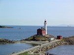
Fisgard (1994) 6 colour, 2 black and white photos in collection. Light tower and detail of gothic style window in old keepers dwelling.


Sheringham Point (1994, 1995) 20 colour photos in collection. Light tower, abandoned dwelling, sunset, old Fresnel lens at local museum.


Amphitrite Point (1995) 9 colour slides in collection (prints available). Lighthouse structure, old keepers dwelling.


Lennard Island (1995) 52 colour photos, 25 colour slides in collection. Traveling to island by boat, keeper in boat, keeper in lighthouse, keeper and wife on station grounds, dwellings, radio room, engine room, details of two fog horn systems, including traditional diaphone horn taken out of service Oct. 1995, light tower, station grounds.


Cape Scott (1996) 23 colour photos in collection. Aerial views.

NOVA SCOTIA

Some of these photos may be viewed at the Nova Scotia Lighthouse Preservation Society site.

Baccaro Point
Bear River
Beaver Island
Black Rock Point
 (new lighthouse)

Black Rock Point (old lighthouse)
Boar’s Head
Brier Island
Cape Forchu
Cape George
Cape Sable
Chebucto Head
Fort Point
 (LaHave River)

Fort Point (Liverpool)
Fourchu Head
Gabarus
George’s Island
Grand Passage
Hampton
 (Chute Cove)

Horton Bluff
Jerome Pont
Louisbourg
Low Point
Maugher’s Beach
Medway Head
Peggy’s Cove
Point Aconi
Port Greville
 (old light, now at Canadian Coast Guard College, Point Edward, N.S.)

Port Medway
Prim Point
Rouse Point
Sable Island
 (east light)

Sable Island (west light)
Sambro Island
Scatarie Island
Schafner Point
Seal Island
Sydney Range
 (front light)

Sydney Range (rear light)
Western Head
Battery Point
Betty’s Island
Canso Locks
Cross Island
 (comprehensive collection including automation day)

Eddy Point
Mosher’s Island
Seal Island
 (comprehensive collection)

Seal Island Lighthouse Museum

PRINCE EDWARD ISLAND

Blockhouse Point
Borden Range
 (front light)

Borden Range (rear light)
Cape Bear
Cape Tryon
Brighton Beach Range
 (front light)

Brighton Beach Range (rear light)
East Point
Murray Harbour Range
 (front light)

New London Range (rear light)
North Rustico
Panmure Island
Point Prim
Souris East
Summerside Range
 (front light)

Summerside Range (rear light)
Woods Islands
Woods Islands Range
 (front light)

Woods Islands Range (rear light)

NEW BRUNSWICK

Cape Spencer
Cape Tormentine
Fish Fluke Point
 (Grand Harbour)

Gannet Rock (comprehensive collection: 700+ prints and slides)
Great Duck Island
East Quoddy
 (Head Harbour)

Letite
Long Eddy
Long Point
Machias Seal Island
 (comprehensive collection)

Mulholland Point
Southwest Head
Swallowtail

NEWFOUNDLAND

Cape Anguille
Cape Ray
Cape Saint Francis
 (dwelling only)

Cape Saint Mary’s
Cape Spear
Lobster Cove Head
Rose Blanche
 (old stone lighthouse)

Three Skeleton Key – A Lighthouse Play


Three Skeleton Key is a one act play I have never heard about before today. It was written as a short story by George G. Toudouze and was first published in 1937 in English.


This is a short story about three men who operate a lighthouse miles offshore of the South American coast.  They love their job untill one day a strange ship arrives.  Suddenly they are unsure if they will survive to see the next day.

Setting

This story is set on a “key” or small island several miles offshore of French Guianna in the early 1900s.  Lighthouse operators whould spend months at a time isolated out on their tiny islands without any contact with the rest of the world. Continue reading Three Skeleton Key – A Lighthouse Play

Reprint – Presentation of a Lifetime Membership from Lightkeepers UCTE Local 20232 To Jim Abram

B.C. lightkeepers honour their champion

By Kristen DouglasCampbell River Mirror
Published: September 25, 2012 2:00 PM 
Updated: September 25, 2012 2:13 PM

[media url=”http://www.youtube.com/watch?v=JN7SZCsEERY” width=”400″ height=”350″]
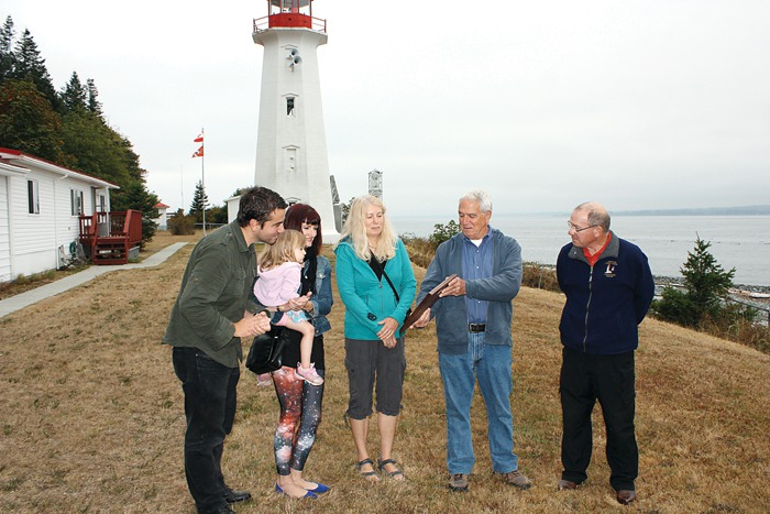
Strathcona Regional District director and former lightkeeper Jim Abram was honoured with a lifetime membership to the B.C. Lightkeepers Union Friday morning at the Cape Mudge Lighthouse on Quadra Island. Pictured from left, Abram’s son Jesse, daughter Melissa Abram, granddaughter Cleo Abram-Veloso, Abram’s wife Wendy, and Jim Abram, gather around to look at the commemorative plaque presented to Abram on behalf of the union.
 

Under cloudy skies, with the imposing Cape Mudge lighthouse looming in the background, former lightkeeper Jim Abram vowed to keep fighting for lightkeepers – the eyes and ears on the ocean. Continue reading Reprint – Presentation of a Lifetime Membership from Lightkeepers UCTE Local 20232 To Jim Abram

Because John Coldwell Has An Inquiring Mind . . .

I just recently married a lovely Filipino lady here in the Philippines. The marriage was held on the beach at the Drill Shack Resort just outside Dumaguete, Negros Oriental, Philippines – actually closer to Dauin.

While in the Dumaguete area I met a Canadian friend, Brian Waddington, who used to live on a lighthouse near to mine at McInnes Island, BC. Brian wrote on August 27, 2012 on his Blogpost:

Because John Coldwell Has An Inquiring Mind I Will Publicly Embarrass Myself And Give Him And His Bride To Be This Story As A Wedding Present

John was the senior keeper at McInnes when I became the junior keeper at Ivory. He retired after 32 years as a keeper. He now runs a truly informative website about the life of a lighthouse keeper on the west coast of Canada. If you have ever wondered about the life of a keeper click on his name.

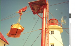
From left to right; workshop and senior keepers house, junior keeper house and garage, landing platform (red pole) control shed for hiline.

Ivory Island is a lighthouse on the north-west coast of Canada. Thirty plus years later I still dream of Ivory. To say it was a seminal time in my life is simply an understatement. Ivory was where I found the start of my spiritual path. Ivory is where the only child I have helped to conceive and father was created. I met my first two spiritual mentors while I was there. Ivory Island introduced me to the Thomas Crosby V which led me to Haisla village which allowed for the occasion where I met my future wife which is why I now live in the Philippines.

Some of my memories are sublime, some are joyous, some are mysterious but this one is just plain embarrassing. First you need a little background information. There are basically two ways to deliver anything to Ivory – helicopter or ship. Helicopter is quick and easy but not so good for heavy or bulky goods.

When goods are brought in by boat the cargo ship anchors, lowers the work boat and they bring the goods to where the ‘hook’ is lowered via the hi line. (look very closely at the first picture, just above the control shed you will see the hi-line running from the tall red pole down towards the water). Once the work boat crew secures the cargo to the hook it is picked up, wound in, lowered, unhooked and the hook is lowered again for the next load. Simple if everything works right not so simple when it doesn’t. This day it didn’t.

Perhaps I allowed the hook to pick up too much speed as gravity pulled it back to the water. Perhaps the stopper and the hook did not mate properly because a gust of wind moved the mechanism at a crucial point. In any case instead of doing what it was supposed to do the hook plunged into the water. Luckily this occurs with some frequency so the work boat was well clear of the rapidly descending hook. The other times this had happened I simply wound the hook in the way a fisherman reels in his line. The hook comes up sets itself properly and then I would again lower it so the work boat could hook up another load.

This time the hook snagged on something. With no way of knowing if it was snagged on a sunken log, a small easily moved rock or something worse I decided to apply a little more power and see what would happen. Bad decision! All of a sudden guy wires are snapping and the tower is starting to bend. No more cargo came ashore that day. What did come ashore a few days later was a five man work crew from Prince Rupert via helicopter with most of what was needed to fix the hi-line.

I say most… what they did not have was the bit for drilling the holes needed to do to put in the new anchoring pins. The drill bit was flown up from Victoria via helicopter. My bad choice was starting to get expensive. It got even more expensive after they had drilled four (if memory serves) five foot long 2 inch wide holes for the pins and then spent a day or two trying to hammer the 2 inch steel pins into the 2 inch holes.

For the next few days the work crew enjoyed a mini vacation while they waited for the proper sized drill bit. It is just possible that this had become such an embarrassment of errors to one and all concerned that they could not fire me without firing some bosses too. In any case I was and am ever so thankful I wasn’t fired.

There you are John my wedding gift to you, your future wife and your web site. Hope you can use it and it brings a smile to your face.

*******************************

Thanks Brian. We could not have had a better wedding gift!

Oops! What Happened to the Water?

A few days ago I posted an article on the lightkeepers being the eyes and ears of the BC coast. While writing it an incident was brought to my mind of my early days in 1977 on McInnes Island. We arrived on McInnes in August 1977 so this had to have happened in Spring 1978.

Every year on the British Columbia coast the herring start their spawn in early spring. We, being curious lighthouse keepers are always interested in the goings on in the sea, from the arrival of the salmon to the arrival of winter storms. We always had our eyes out for something happening.

Well, one of the things we had been warned about was pollution. One morning I awoke and the ocean around the lighthouse as far away as Price Island, two kilometers away, was a milky white as though lime had been dumped in the ocean. Nowhere could I see blue sea except distantly in front of the lighthouse.

white water – photo Flickr by poecile05

I was astounded! What had happened? I had no idea. Last night everything was normal; today, total chaos!

I phoned Coast Guard Radio in Bull Harbour and reported this accident, not knowing what it was or how to describe it. The operator said he would pass it on to the Coast Guard. 

That was it? The ocean was polluted! I could not see a foot into the water! That was all they were going to do? Continue reading Oops! What Happened to the Water?

Lightkeepers are the Eyes and Ears of the Oceans

Isn’t this a pretty neat photo? But what is it you ask?

If you run Google Chrome as a web browser1 you could use the Search by Image extension to find other copies of the photo and then the website, and then what is shown in the photo. Here I have just presented a photo with no information (caption).

This photo was shown in Facebook at one time I think. Through the browser extension mentioned above I found the origin of the photo and an explanation. Continue reading Lightkeepers are the Eyes and Ears of the Oceans

Reprint – Our Ocean Backyard – Invasion from the Sea

As a lighthouse keeper, we watched every Winter and Spring for “Asian” debris to wash ashore around our lighthouse. Mainly we were interested in the glass fishing floats, but we came across hundreds of items every year, and this was in the years 1977 – 2001. Every piece of this debris was usually coated with goose-neck barnacles and other marine life which came from who knows where.

Now we are terrified of a few marine animals on a barge, or motorcycle coming ashore from the tsunami debris? Please read the article below and come to your own conclusion.

In my opinion, debris, with marine life, has been coming ashore around the world. How do you think isolated islands get populated?

***************************

Our Ocean Backyard by Gary Griggs – Article #111

INVASION FROM THE SEA

A 66-foot long concrete and steel floating dock washed onto the Oregon coast near Agate Beach in early June. The Japanese consulate in Portland confirmed that the dock was one of four used by commercial fishermen for unloading squid and other catch at the port of Misawa, that had been ripped away from the coast during the March 2011 tsunami. It took about 15 months for the floating structure to make the roughly 5000-mile trip across the north Pacific, traveling about 10 miles a day. 

Scientists from Oregon State University’s Hatfield Marine Science Center discovered that the dock contained an estimated 100 tons of encrusting organisms, or about 13 pounds per square foot. These included several species of barnacles, as well as mussels, starfish, urchins, anemones, worms, limpets, snails and algae – dozens of species. 

Although most of the individual species are unique to Asia, this smorgasbord of marine organisms is similar to what you might find on a wharf or piling along the coast of California.  Continue reading Reprint – Our Ocean Backyard – Invasion from the Sea