As a lighthouse keeper I was interested in fishing, and sometimes paused to watch the seine fishermen catch fish.
I retired twelve (12) years ago, and even at that time the practices in the following video were allowed by the Canadian Department of Fisheries and Oceans (DFO). Well, maybe not allowed, but never monitored. I was appalled at the time, of the number of fish that fell injured through the large seine nets. I could not even make use them as they were so injured that they sunk rapidly to the bottom of the ocean.
Please watch and be dismayed. This takes place in Fisheries Area 6 – my lighthouse was in Fisheries Area 7. The following map shows the Fisheries Areas on the BC Coast.
New evidence shows thousands of unwanted salmon are needlessly killed when no one is watching the fishermen: Groups want oversight
My website here is about British Columbia (BC) lighthouses and the environment surrounding them.
Just recently a good friend sent me an email to a website called Picture BC, a delightful photo and video tour of the province of British Columbia, Canada – as beautiful now as when it was created in 2008.
Picture BC photo
According to the site:
Picture BC is an initiative of the Union of British Columbia Municipalities (UBCM), an organization representing the communities participating in this website. The idea and support for Picture BC came from the Province of British Columbia.
The site contains a five (5) minute video tour of the whole of BC (above) which is very well done. If you have never been to BC, you will want to come and visit after seeing this video. If you plan on coming, this is where the lighthouses are. The video shows two or three lighthouses near the end of the clip but there are many more on the BC coast.
There are interactive maps of the regions of BC with links to most cities in the province.
There are also some beautiful photos of major tourist destinations in BC, as well as scenes which cannot be seen unless you take a helicopter or plane ride.
The website is done with Adobe Flash player so it is a bit tricky to manouever around, but have patience – it is worth it!
For an update on what a Mise Tale is then please see Mise Tales One.
Lighthouses in a Bottle
I have heard of ships in a bottle but never lighthouses in a bottle until I came across the photo at the left. It has been sitting on my computer for ages and I forgot where it came from.
Doing a Google Image Search I came up with Village Crafstmen and lots more lighthouses in a bottle – some multiple ones as the photo on the right shows.
Their address and contact information is on their website.
I published a report January 04, 2012 on the building of McInnes Island lighthouse in 1953 based on the adventures of Ken Stewart who was part of the construction crew. I updated that post later with more information in the form of a PDF file.
1977
When I arrived with my family in the winter of 1977 the first thing we did was explore the island. Pictured left is a small log cabin buried back in the woods on the trail to the SW tip of the island.
Now let’s skip ahead to December 09, 2012 when I received an email from Mrs. K. Marshall with another photo of the same cabin taken about twenty-two (22) years earlier! What a delight to see what she had written on who built the cabin and also for her to see my photo taken so many years later.
In her email she said:
My grandfather James “Jimmie” Smith was a junior lighthouse keeper on McInnes for a few years in the late 1950s. He was there with my grandmother Mildred “Millie”, and their 2 daughters who were teenagers at the time, my mother Carol and her sister Sharon.
These photos are of a driftwood log cabin that my Mom and her sister built on the island. I’ve been scanning old family photos this past week and have quite a few from the lighthouses.
I’d be really curious to know if the cabin was still standing while you were stationed there.
Well, as I told her the cabin was there in the winter of 1977, but by the summer of 1978 we had burnt it down as it was very unsafe for anybody to venture inside and could not be repaired. An email from her Mom, the Carol mentioned above, says:
Pool area – labelled
[To build] the cabin I pulled and carried the logs from just below the cabin from the beach. The shakes I cut those with a hand saw to length. Split them with Mom’s best butcher knife and a hammer on the back of the knife….that didn’t go over at all well…believe me.
McInnes island – no labels
That end of the island where the cabin was. No one had trails there at all. Sharon and I started to explore that area. Dad, Bruce and Tony when they realized where we where disappearing to, they cut the logs of the trail so the adults could get into that area.
The swimming pool was past the
The swimming pool
cabin. You went up the hill and there was the natural crater in the rock. Dad and Mom used a washing soda to clean it all. Then the guys had a pump and hoses. They pumped new sea water up into the basin. Dad made up a bag of concrete to sort of plug one end of the crater. We just lived in that area all good days. Lots of nights we spent in the cabin. Continue reading McInnes Island Lighthouse – a Tale from the 1950s→
A long time ago back in 1969 on my first lighthouse at Pulteney Point, we used to recycle glass bottles by taking them out in the boat or canoe, and breaking the washed glass bottle over the side of the boat and letting the fragments settle onto the ocean floor. It was not pollution as such as most glass is 90% sand.
Have you ever seen frosted glass pieces in the beach sand? Usually many varieties of colours from the sea green pieces of broken glass from Asian fishing net floats (glass balls) to the browns and whites of everyday bottles. Usually the bottle is thrown in the sea from land, thrown overboard from a boat, or dumped from a garbage scow off a big city. Glass is the most recyclable of modern user items, even if it is just dumped in the ocean.
The whole bottle can be returned for refilling, the broken ones can be melted down and remade into new bottles. But the sea does it differently. With the pounding of the waves on a beach, each piece of a broken glass is ground down, rounded off, and frosted by the action of sand moved by the waves. Another name for these polished glass shards is mermaid’s tears.
If you are lucky you can find every colour, with red and blue harder to find. At the end of this article I will give you a way to make your own sea glass. It is very beautiful as a floor in an aquarium, used to support candles, make sun catchers – uses are endless.
What brought this story to mind was this news article:
glass-beach-mackerricher-park-fort-bragg-california – Photograph by Jef Poskanzer
In MacKerricher State Park, near the city of Fort Bragg in northern California, you will find a beach littered with glass. Over decades of crashing waves the glass has been smoothed and rounded, transforming the shoreline into a colourful palette of pebble-like glass and sand. . . . more
*********************************
Now, as promised, if you do not live near a beach with sea glass, you can make your own easily. My last lighthouse was on a rocky island with no beaches – hence no sea glass.
Go to your nearest rockhound shop and purchase their cheapest rock tumbler. The one I had was two rubber barrels on two rollers run by a small electric motor (similar to photo on the left). The next item you need from the rockhound shop is their coarsest grit to rough up the glass.
beach Glass from a Tumbler
Carefully break any bottles you want to tumble, fill a tumbler barrel with the broken glass, add water and grit, close the lid securely and drop the barrel on the rails and let it run all night. Check in the morning if your glass is what you desire. If not, then tumble some more.
It is hard to tell real sea glass from the tumbled variety, and you have an infinite variety of coloured glass to choose from – just go to your nearest liquor store – especially in the wine section! Check out this website for more information.
glass-beach-mackerricher-park-fort-bragg-california – Photograph by Jef Poskanzer
In MacKerricher State Park, near the city of Fort Bragg in northern California, you will find a beach littered with glass. Over decades of crashing waves the glass has been smoothed and rounded, transforming the shoreline into a colourful palette of pebble-like glass and sand.
From 1906-1967 (the start date is up for debate), seaside towns were known to use the coastline as dumps, Fort Bragg was no different. After the devastation of the San Francisco earthquake the streets were filled with rubble and trash was dumped on the coast for the ocean to wash away. This of course, included plenty of glass.
glass-beach-mackerricher-park-fort-bragg-california – Photograph by John ‘K’ on Flickr
It wasn’t until 1967 when city leaders and the North Coast Water Quality Board realized what a mistake it was and sought to relocate the dump away from the ocean and clean up the shoreline. After the clean-up and more decades of crashing ocean waves; only smoothed and rounded glass mostly remained.
glass-beach-mackerricher-park-fort-bragg-california – Photograph by Jef Poskanzer
Glass Beach was purchased by California State Parks in October 2002. The Coastal Conservancy, with the City of Fort Bragg and the Mendocino Land Trust worked for over four years to assemble funding for the purchase of the 38-acre property. The Land Trust managed waste removal and clean-up, and completed botanical, archaeological and erosion control work that was required prior to purchase by State Parks. Since the Pudding Creek Trestle was completed in 2007, visitors may now walk from MacKerricher State Park to the headlands at Glass Beach connecting this highly visited “city” park to several miles of beach trails.
glass-beach-mackerricher-park-fort-bragg-california – Photograph by mamojo on Flickr
As word of this unique beach spread, more and more visitors descended onto Glass Beach. Drawn to the beautifully smoothed and rounded glass, visitors began pocketing the glass with each visit. This has greatly diminished the amount of glass on the beach. And since it is now State Park property it is a misdemeanor to remove any artifacts. While there is still glass to be found the area has been greatly depleted.
In addition to searching for glass, the beach has an interesting array of tide pools to explore. Crabs, mollusks, and many aquatic plants make their homes in these ever-changing environments.
On October 14, 2011 I wrote the article Thomas Crosby V – One of the “Bookboats” which described the church mission boat from the United Church of Canada. Now, a good friend Carol Jeffrey found a reference to a new mission boat, the Columbia III which worked for the Columbia Coast Mission from the Anglican Church. Below is a bit of information on this service to isolated posts on the BC coast , including lighthouses.
While the headlines of Campbell River newspapers fumed over the millions of public dollars recently allocated for a consolidated mid-Vancouver Island hospital, a small crowd gathered at the city’s Discovery Harbour Pier for a tea celebrating the 50th anniversary of the launch of the hospital ship Columbia III. She was one of the last in a long line of vessels operated by the Anglican Church’s Columbia Coast Mission. The Mission provided medical, non-sectarian religious and social services to remote settlements, lighthouses, logging camps and First Nations villages along BC’s inside coast from 1905 to the late 1960s.
The launch of Columbia III on October 13, 1956, took place at Star Shipyards (Mercer’s) in New Westminster, just 100 feet from where the second Columbia had been built hy the Dawes Shipyard in 1910. Robert Allan and his son Robert F. (Bob) Allan were in partnership as Vancouver naval architects when Columbia III was designed. Propulsion was a 182-hp Gardner 8L3 (still powering the vessel). Diesel generating and heating units were installed, as well as a propane sterilizer in the hospital cabin, x-ray machine, propane range and refrigerator in the galley and a Spilsbury & Tindall radio-telephone.
The coast has changed radically in the half century since the Columbia III glided down the launch-ways at Star Shipyard (Mercer’s) in New Westminster on October 13, 1956. That year a new hospital was in the offing for Campbell River and there were small hospitals established in Alert Bay and Powell River, but there were still hundreds of people living on the isolated coast between Sechelt and Seymour Inlet with little or no access to medical care or regular social contacts. No matter what the religious convictions of these people, the arrival of the Columbia was a welcome sight.
Sea Kayaking Tours in BC Canada
The Columbia Coast Mission saved hundreds of lives when its vessels hastened to logging camp accidents. The mission also provided a cherished social outlet. “It was very exciting when the Columbia came because there was very little entertainment for us,” remarked one of the attendees at the 50th anniversary tea held onboard Columbia III. In those days the Columbia’s staff brought books, showed movies and hosted Christmas pageants, complete with a portly Santa Claus. Mothership Adventures, which offers eco and cultural tours in inside waters with the Columbia III, has had new owners since 2005, Ross Campbell and Fern Kornelsen of Sonora Island, and they welcomed the idea of the 50th celebration. The vessel’s aft double doors, designed originally to provide access for stretchers, were opened wide to a crowd which filled the saloon and aft deck to reminisce about the Columbia Coast Mission. The Campbell River stop came at the end of a 50th anniversary voyage which originated in Port McNeill and threaded its way south with an enthusiastic group on board, all the members of which had past associations with the coastal ‘mission ships’. Along the way they revisited many homesteads, settlements and villages which had been regular stops during the Columbia’s service.Well aware of the Mission’s historic service Campbell and Kornelsen were pleased to return Columbia III to this part of the coast. But they weren’t prepared for the depth of feeling many still hold for the Mission and its ships. Wherever they tie up people have memories to share. On the recent anniversary cruise a young man asked the Columbia’s skipper to give a blast on the ship’s distinctive whistle as they passed the Alert Bay home of his 90-year-old grandmother, “for old time’s sake.” At the Whaletown wharf on Cortes Island, once frequented by the Coast Mission vessels, a small crowd gathered to watch Columbia III pull alongside. “I got a call from a neighbour,” said Jan Boas. “She said, ‘The Columbia is coming!’
This summoning call was heard frequently on this coast in days gone by. Prior to the advent of the Columbia Coast Mission in 1905 there were more than 100 isolated logging camps and settlements scattered along the coast and accidents were alarmingly common. The only hope, in the case of serious injury, was to row out into one of the main passages in an often futile search for a passing freight or passenger steamer. A lucky few survived under these circumstances. The arrival of four dead loggers in Vancouver on a steamer galvanized the Mission’s founder, Reverend John Antle, into action. He persuaded his church to launch the first Columbia and later raised funds for four hospitals throughout the region.
By the time the Columbia III was launched in 1956, the coast was undergoing rapid change. Timber licences were being awarded almost exclusively to large companies, cutting out the smaller operators. This, and greater utilization of float planes over sea-going vessels and the establishment of highways and ferry connections between coastal centres, began to depopulate the coast. By the early 1960s only a hardy few still lived in isolation. Even the chaplains from the Mission took to the air in a Cessna floatplane, a practice which continued through the 1970s.
A gathering on the foredeck of the Columbia III, Kingcome Inlet in the 1960s. Judging by the finery and the babe in mother’s arms and the Columbia Coast Mission chaplain to right in photo, this was probably a christening ceremony
The last sea-going chaplain with the Columbia Coast Mission, Rev Ivan Putter, arrived in 1965. He had a Decca radar installed so, while the Columbia III was by then serving as mobile aviation fuel rendezvous and a base of operation for the plane which could branch out to isolated pockets of the coast, the vessel continued to help the sick and injured and save lives when the plane was fogbound. However in 1967 the Columbia III was put up for sale. By 1982 the Mission had ceased operation.
Columbia III then passed into the hands of a string of owners and was a liveaboard in False Creek in Vancouver and in a pretty run-down condition when acquired by Bill McKechnie of Victoria in 1990. He worked with shipwright Paul Heron and several Victoria craftspeople on a well-thought-out and classy refurbishment. Original areas such as the doctor’s office and galley were reconfigured and, below decks, the chapel, chaplain’s stateroom and infirmary were converted to cabins and accommodation for 10 berthed passengers and crew members. McKechnie also started Mothership Adventures, a successful ecotourism venture which enabled Columbia Ill’s guests to explore wilderness areas of the mainland around the Broughton Archipelago and the Central Coast through a combination of cruising and kayaking.
A group of people, all with an association with the mission ships, revisited some of the old haunts between Port McNeill and Campbell River in early October, 2006. Here they are seated in Columbia Ill’s main saloon, the former hospital cabin. The large bright windows and mahogany cabinetry and furnishings were part of the extensive 1990s refurbishment overseen by owner Bill McKechnie in Victoria.
The inset photos show the wheelhouse and the engine room with the 8L3 Gardner that was in Columbia when launched 50 years ago.
Mothership Adventures and Columbia III were sold in the early 2000s to a Seattle owner who intended continuing the business in BC waters. However, he couldn’t make his way around the Canadian 60-ton master’s ticket requirement for Columbia III. Meanwhile Ross Campbell and Fern Kornelsen, who had fallen short in their attempts to buy Mothership Adventures from Bill McKechnie, continued to make it abundantly clear to the US owner that, if he wanted to sell, they would buy. They became owners in early 2005.
The Columbia III in her role as a ‘sea kayaking mothership’.
“The Columbia is always welcome wherever we pull in,” says Ross Campbell. “We feel we are custodians of a significant vessel in BC’s maritime heritage and we try to live up to her good name.”
In that spirit Campbell and his family have agreed to make the ship available for weddings and memorial services for the many people who hold the Columbia’s memory dear. And, Ross adds, “We’ll be working to give her another 50 years on the coast.”
Vancouver (CP)-A missionary of the sea plays a vital part in the lives of 4,000 persons along the lower British Columbia coast.
From inlet to inlet, the mission ship Columbia II skippered by Capt. George A. MacDonald, a friendly 70-year-old Vancouver man, brings spiritual and physical comfort to loggers, fishermen and settlers in some 225 isolated communities.
The sturdy 100-foot diesel-driven ship plies from Stuart Island and Cape Scott at the northern tip of Vancouver island.
Veteran Chaplain
The chaplain is Canon Heber Greene, a veteran missionary, and the ship’s medical facilities are directed by Dr. J. G. Kempff.
In the tiny chapel, there have been weddings, christenings, confirmations, and funeral services.
“We handle hatches, matches and dispatches,” says a crew member.
The ship is one of four operated by the Columbia Coast mission of the Church of England in Canada.
Many mercy missions are undertaken by the 48-year-old Columbia. Last year she logged 31 emergency calls for sickness and accident cases.
“Calling the Columbia” is a frequent call over the ship’s radio-telephone, coming from the coastal districts dotting the rocky island shoreline.
One Mishap
She takes nine six-week cruises a year, and only once has she suffered a mishap. In 1948 she piled onto a reef in Warner Bay and was laid up some six weeks for repairs.
Capt. MacDonald has been with the Columbia for 17 years. With him he has engineer Bob McCree, Jack Owens as cook, and Bob Anderson, deckhand.
Off the main deck is a two-bed hospital equipped with examination table, dental chair, drugs and surgical instruments. Only minor operations are performed. Serious cases are taken to hospital at Alert Bay, the Columbia’s home port, 225 miles northwest of Vancouver.
There are recreational comforts too. There is a reading room, much used by lonely settlers, and a movie theater, where various films are shown during visits to upcoast ports.
“We feel we cover the whole life of the people,” said Canon Alan Greene, superintendent of the mission and brother of the Columbia’s chaplain.
Better Than Planes
Talk of the mission ship being replaced by an airplane gets little sympathy from mission authorities.
Storms and fogs have been battled by the Columbia on mercy missions. Under similar bad weather, a plane would be grounded.
“The plane lacks the personal touch,” added Canon Alan Greene, and his views are shared by Captain MacDonald.
The first mission boat was launched by Rev. John Antle in 1905 when Columbia Coast Mission was founded. It voyaged for man years along the coast, was replaced by the Columbia II. The old and expensive Columbia II, too, may be replaced, this time by a smaller vessel.
Of the 13,259 miles covered by the Columbia in 1952, 1, 295 miles were logged on emergency calls. She made a total of 1,047 calls, during which 807 cases were treated. Her sister ship, the John Antle, the Rendezvous, and the Veracity, travelled 6,000 and 5,383 miles, respectively. Three vessels are confined to mission work only.
Such coverage entails an annual expenditure of $75,000, most of which is incurred by the Columbia. The Community Chest of greater Vancouver bears the major part of the ship’s operating expenses, with the provincial and federal governments contributing small grants. The balance is provided through church contributions and private donations.
****************************
FOOTNOTE:
1 Jeanette Taylor is a Quadra Island-based writer and interpreter of BC coastal history and heritage. She has worked with the BC Archives aural history division and held curatorial and programming positions with the Campbell River Museum. She is the author of River City: A History of Campbell River and the Discovery Islands (1999, Harbour) and Exploring Quadra Island: Heritage Sites and Hiking Trails (2001, Harbour) and is writing a history of the Discovery Islands and adjacent inlets.
If your eyesight isn’t quite what it was, you may need a hand spotting this luxury lighthouse that is set to become a cult destination for lovers of the Northern Lights. You can see the red roof and white walls just peeking out from the top of the right side of the island, but without some serious navigating skills you may still have trouble finding it altogether.
No roads lead to the Littleisland Lighthouse at Litløya, Vesterålen, Nordland, Norway, and that extended address may still not be enough to get you there. Accessible only by boat, a more useful location may be it’s co-ordinates – (+68° 35′ 37.91″, +14° 18′ 34.89″) – which will take you 130 miles inside the Arctic Circle.
Guests arriving from the airport at Narvik or Evenes (accessible via Oslo from the UK) travel by bus to the small fishing community of Vinje, where they will be met by lighthouse staff and provided appropriate clothing for the short but exciting trip by boat to the island.
But for many, the real beauty of staying at Littleisland Lighthouse is what can be seen at night during the winter months…
The 2012/13 “season” for viewing the aurora borealis is predicted to be the most spectacular for 50 years, according to NASA who make the prediction based on reports of solar wind activity around the sun. This means that from now until March, skies such as those pictured above should be reasonably commonplace for visitors to this remote part of Norway, just northwest of the scenic Lofoten Islands. At night, guests will be kept warm with blankets, hot beverages and a sweet treat while they enjoy the view.
The lighthouse, built in 1912, is celebrating its centennial year, and owner Elena Hansteensen believes it offers the right mix of boutique luxury and complete isolation. Elena and her staff provide locally-sourced healthy meals, which is fortunate because there isn’t any other food available on the island unless you’re a dab hand at fishing.
Inside, the lighthouse offers two double rooms, a cosy library and dining area – all with spectacular views of the sea and sky. But the island has one or two more treats in store for those brave enough to visit…
When day breaks you can explore the island’s Stone Age settlements, which were established some 6,000 years ago, or visit the remains of its 19th century fishing village, as well as spot orcas and other species of whale off the island’s coast.
Exploration can be done alone or with one of the lighthouse staff as a guide. Alternative activities include fishing, or simply relaxing at the lighthouse with their resident Norwegian forest cats Sirius and Sara. The lighthouse itself is still very much in use, its LED light powered by solar panels and flashing every 10th of a second to sailors passing the rocky coast.
Those in fear of the weather will be relieved to hear that Littleisland is blessed with a surprisingly mild climate. While you should probably forget your swimsuit, thanks to the Gulf Stream average winter day temperatures are above freezing, and snowfall is light and fleeting.
Rooms at Littleisland Lighthouse are available from 1 November 2012 to 1 April 2013. Maximum four persons in two double rooms. Stays available for two or three nights, arrivals recommended on Monday, Wednesday and Friday. Two nights costs £310 per person, three nights £420 per person (subject to exchange rates), and includes boat transfers to and from Littleisland, all meals, and a guided tour of the lighthouse. Norwegian Air offers return flights from Oslo to Evenes from around £150. Find out more about Littleisland here.
This not a lighthouse story, but it shows what interests a lighthouse keeper. If you live near the sea, you are always interested in ways and means of travelling, fishing , and exploring on the ocean. It is only natural. Here is my newest find – a SUP!
****************************
After posting the story “Stand” – An Adventure Documentary on November 14, 2012, I was really intrigued by the surfboards the people were using in the film. They were not really surfboards as they appeared to be too heavy even though made of native British Columbia (BC) cedar wood.
A Cedar Strip Stand Up Paddleboard (SUP)
As you can see from the photo above, they are called a Stand Up Paddleboard (SUP). I had never heard of them before, and thought they would be ideal for adventurers on the BC coast, or anywhere! Continue reading Re-inventing the Wheel, er, The Paddleboard→
STAND, presented by Quiksilver Waterman, will take viewers on a journey through the waters of B.C.’s west coast. Through the stories of an aboriginal high school class building their own stand-up paddleboards as a form of protest, the efforts of expedition stand-up paddler Norm Hann, and the powerful surfing of iconic west coast native Raph Bruhwiler, the diversity of people, landscape and wildlife that would be affected by an oil spill
will be articulated. STAND will take you to the core of the issue and unfurl the soul of B.C.’s west coast one paddle stroke at a time.
Cedar Standup Paddleboard
The crew is currently raising funds through the popular crowd-sourcing platform IndieGoGo, in order to complete post-production and bring this story into the mainstream consciousness. You can become a champion of the Great Bear and help protect our precious coastlines by donating to the project and in return receive some great rewards.
October 23, 2012 – “STAND” the new film from b4apres Media in association with Dendrite Studios will take you into the heart of the largest temperate rainforest on the planet—the Great Bear in British Columbia, Canada. Hung on the skeleton of a good ol’ fashioned adventure undertaken by a group of surfers, the potential effects of introducing super tankers to these pristine waters will be articulated. As the crew moves through this remote region under their own power, the landscape will be unfurled one paddle stroke at a time and punctuated by the faces and fears of the First Nation people who call this garden of Eden their home. Not just an efficient mode of transport, a stand up paddleboard expedition will be symbolic of “standing up” to preserve this last bastion of rainforest. Captured in cinematic High Definition, the film will bring the Enbridge Pipeline debate into the collective consciousness in a way that will have you fishing in your basement for that old fluorescent wetsuit.
Quiksilver Waterman has signed on as the presenting sponsor for STAND. Since the crew had the concept for the film last year, they have been searching for a partner to support the project. That partner, however, needed to be the right fit and believe in the cause, in protecting British Columbia’s West Coast. Thankfully Quiksilver Waterman along with the Quiksilver Foundation 1 share a strong commitment to the environment.
Norm Hann and Raph Bruhwhiler are both Quiksilver ambassadors and agreed to join the project from the beginning. Both are true waterman and dedicated to the protection of the waters that they derive so much enjoyment from as well as the occasional seafood platter. Having Quiksilver Waterman involved makes the perfect trilogy and will allows the filmmakers to illuminate the stories, adventures and landscapes that abound in this truly magic part of the world.
Long protected by the 1972 Trudeau government moratorium on crude oil tankers plying British Columbia’s north coast, these waters are now facing the risk of oil spill. Potentially, 225 Very Large Crude Carriers (VLCC) per year would each transport approximately 2 million barrells of oil through the Great Bear Rainforest. In context, today’s supertankers carry ten times the volume of the Exxon Valdez oil spill. Put simply, the pristine marine and terrestrial ecosystems as well as the people of the Great Bear would likely not recover from such an incident.
This issue is perhaps the most important environmental issue in B.C. history. Whats more, a catastrophic oil spill could reach beyond borders and impact much of the Pacific North West coastline.
Visit the official Dogwood Initiative Website to learn more and find out how to get involved.
1 For years, Quiksilver and Roxy have been actively engaged in charitable activities, both locally and globally. Quiksilver recognises the concept of corporate social responsibility and benevolence. We want our philanthropic work to have impact beyond what we do as one company and believe that we can do this by coordinating the support of other organizations and individuals. The Quiksilver Foundation was formed to bring all of Quiksilver’s charitable giving under one umbrella. The Foundation commenced its activities as a private foundation in October of 2004.
With offices in Europe, Australia and America, Quiksilver has the capability of reaching people worldwide. Quiksilver has the vision of making a difference to community and environment through the Quiksilver Foundation.
The Quiksilver Foundation is a non-profit organization committed to benefiting and enhancing the quality of life for communities of boardriders across the world by supporting environmental, educational, health and youth-related projects.
The Quiksilver Foundation has a commitment to improve the quality of all our lives.
We desire to benefit:
Local Communities, including schools, local charities through support and outreach programs;
Major special projects and organizations sharing our focus on children, education, science, oceans and the environment.
Do you want to visit some of British Columbia lighthouses? A lot of them are isolated, but there are a few that tourists can easily see. Some of these are manned; some are automated.
One of the best websites for finding the location of the lighthouses is Ron Ammundsen’s Lighthouses of British Columbia website. On the opening page he has maps of manned/staffed and unmanned lighthouses and their locations. This will show you what is available, and where they are located. To find photos and information on the chosen lighthouses check out Google.
One of the main items you will require is a place to stay. When flying to British Columbia via International Airlines (from another country) your point of entry would be Vancouver International Airport (YVR). From there you have a variety of ways to accommodate yourself – from hotel, motel, bed and breakfast, camp site, hostel, inn, resort, etc. Select from the list on the Hello BC website. Enter your dates, town, and preference, and select a place to stay. Really easy website to find your way around.
The next thing after a room for the night, is a place to eat. Canada is well-known for its diversity in the culinary arts, and British Columbia is no exception. The easiest way is to introduce you to a special webpage called Dining, again from Hello BC. This is an interactive menu connected to a BC map. Pick what type of food you want, where you want to eat, and wait for the results. It is well organized and easy to use.
The choice is amazing! Your selection may be saved as a PDF file for reference. Pick your town, pick your food and grab a cab to good dining. The nice thing is you can look on the map to see if a location is near your place of residence for any place in BC. The map (left) shows the 538 results from just selecting West Coast. Each red flag is a city with multiple locations in each. Each result will give you location, telephone number and website if available. A very comprehensive help page.
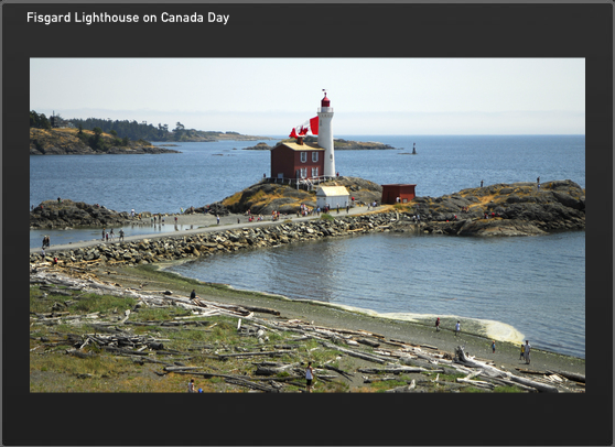
Fisgard Lighthouse
Before you come you should decide where you want to go, and what lighthouses you want to see. Most of the available lighthouses will be seen in and around the cities of Vancouver, and Victoria, BC. Others are visible from the ferries, and up and down Vancouver Island. On the Hello BC website on the Things To Do page there are no exact listings for lighthouses but if you type lighthouse in the search box (upper right) you will get a page of lighthouse listings, things lighthouse, resorts near lighthouses, etc. With the map from the website on Lighthouses of British Columbia you can then sort out where you want to go and which lighthouse you may wish to visit..
If you want to get off the beaten track, you can fly into many places or take ferries, hike in, or even rent a local water taxi or fish boat. The opportunities are unlimited depending on your time and finances. On the Hello BC webpage is also a section on Transportation and Maps listing many services available in BC.
Take your time, talk to other tourists, and if you have any questions, maybe I or other readers can help you out. They don’t call it Beautiful BC for nothing. Enjoy!
******************************
To help you enjoy the coast more, it might be helpful to read up on a few of the things you might find at the shoreline. A great website for this is Vic High Marine. Check out the information on all things you might stumble across, or see on your trip.
Any more good advice out there? Please send it on and I will post it.