Category Archives: Ships & Shipping

Minnie Patterson and the “Coloma” off Cape Beale 1906

– Reprinted  courtesy of The Department of Fisheries and Oceans Canada
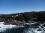
Cape Beale - photo Justine Etzkorn

Cape Beale, . . . a lighthouse which later came to notice in a gallant and romantic rescue resulting from the actions of Mr. and Mrs. Paterson who kept the light from 1895 to 1908.

In December 1906, the United States barque Coloma left the Puget Sound with a cargo of lumber for Australia. There was a gale from the southeast and, cracking on to take advantage of this fair wind to clear the Straits of Juan de Fuca, the old wooden vessel sprang a leak when she encountered a heavy sea off Cape Flattery. With her decks awash, and the gear aloft carrying away as she pitched in an enormous swell, the Coloma was soon unmanageable and hoisted her ensign upside down in token of distress as she drifted down to leeward and the outlying reefs of Cape Beale.

In this position, and doubtless having let go her anchors to the bitter end, the barque was sighted from the lighthouse. The only chance of help lay in alerting the Quadra, then under the command of Captain Charles Hackett, which Paterson knew was lying at anchor in Bamfield Inlet, six miles away. The lifeboat, it will be recalled, was not on station at Bamfield until the following year. Telephone lines were down and the light keeper was unable to leave his foghorn which required constant attention. Although the trail was blocked by fallen trees and lay for much of the distance along a rocky shore. Mrs. Paterson at once insisted on making the journey herself. It was then night, and in darkness and dreadful weather she set off with a lantern and her dog, hoping against hope to be in time.

The plan was to get the news to James Mackay at Bamfield who would row off to the Quadra and raise the alarm. Arriving at the house physically exhausted, drenched to the skin and with her shoes and clothing ripped to pieces, it was found that Mackay was away from home repairing the telephone wires. Nothing daunted, Minnie Paterson and Mrs. Mackay themselves launched the boat and came alongside the Quadra as daylight came. Captain Hackett weighed anchor at once and the Quadra punched her way out of the Inlet against a heavy swell rolling in from the Pacific. Off Cape Beale the wreck was sighted, a boat was lowered under the command of the second officer Mr. James E. McDonald, and the distressed crew were recovered. No sooner had the boat returned to the Quadra than the derelict parted her cables and drove ashore to destruction. Mr. McDonald was promoted to chief officer shortly afterwards.

Immediately after her courageous action, and before the return of the Quadra with the shipwrecked men, Mrs. Paterson walked all the way back to the lighthouse. She had five children to look after and her husband was constantly at work in a period of rain and bad visibility. It was another week before communications were restored, and only then did the Paterson’s learn of the triumphal rescue which had resulted. Unfortunately, the results of Mrs. Paterson’s tremendous exertion soon made themselves apparent and she never entirely recovered, dying five years later.

More information and photos here on the Tofino History website.
Weather Observing – a Large Part of the Job

Note:- How to obtain an up-to-date weather report from a BC lighthouse

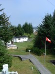
McInnes with weather instruments (lower half) – photo John Coldwell

One of the duties on most of the lighthouse stations, and especially on McInnes Island, up to 2003, was the reporting of local weather (weather visible in the immediate area of the station) to Environment Canada (EC) – earlier called the Atmospheric Environment Service (AES) – for re-broadcast to boaters, pilots and climatologists.

This became even more important after the Tropical Storm of October 1984 hit the British Columbia coastline.

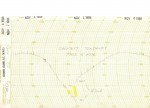
Extreme Tendency November 05, 1988 – scan Glenn Borgens

Every three hours during the day, starting at around three o’clock in the morning we would collect the information on sky condition, visibilty, wind speed and direction, rain/snowfall, wet and dry bulb temperatures plus maximum and minimum temperatures, station pressure and tendency (whether pressure was rising or falling and how rapidly), and sea and swell height. This was then recorded on AES forms or in a notebook depending on the station. Not all stations reported or had the instruments for all observations. These records were forwarded to AES every month along with a Climate Summary for the month. Continue reading Weather Observing – a Large Part of the Job

Foghorns and the Changing Coastal Soundscape

 Foghorns and the Changing Coastal Soundscape

Technology and politics are changing the tune of the maritime chorus

April 20, 2012 | 3:46 PM | By  and with thanks to Climate Watch

Read the full text version of this story at KQED’s QUEST site. (more photos – retlkpr)

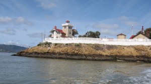
East Brother Island, with the 19th-century lighthouse on the left and fog signal building on the right. - Craig Miller

East Brother Island, with the 19th-century lighthouse on the left and fog signal building on the right. Continue reading Foghorns and the Changing Coastal Soundscape

Books on BC Lighthouses

Over the years since I started this website in 2005 I have collected many books on British Columbia lighthouses. Some with only a reference to lighthouse, others dedicated exclusively to BC lighthouses like Donald Graham’s books.

Later I will dedicate a page to each book as I have to some earlier ones, but right now I am more interested in showing newcomers what is/was available so that they will recognize them when they are found in a flea market or garage sale.

If you click on the photo left, it will take you to a modified page from my old website which lists books that I have collected over the years. It will also specify if the book is available for sale or not.

Listed below are a few more lighthouse-related books that did not make it onto that list before I created this new website. If you can, please send me an email or comment about a new book that you have found. I will add it to the list and we can make this as complete as possible. Also, if possible, would you please also send a scan of the front cover so I can add it to the pages. You know the old saying “A picture is worth a thousand words”. Thank you.

Shipwrecks Along the West Coast Trail – Richard E. Wells – Sono Nis Press

Silent Seige III – Bert Webber – 301 pages – Webb Research Group (December 1992) 

The Last Island – Alison Watt – Harbour Publishing – 978-1-55017-296-6 · 1-55017-296-4
$34.95 · Hardback 6.5 x 9.5 · 192 pp · September 2002 (Available)
http://www.harbourpublishing.com/title/TheLastIsland
ISBN-10: 0936738731, 10.7 x 8.3 x 0.9 inches

There’s A Landing Today – Richard E. Wells – Sono Nis press


The Lighthouse as a Sovereignty Symbol

Philippine flag over Pantag Shoal

In the early days of exploration a flag of ownership was placed upon new-found-lands to claim ownership, even though on the other side of the island, or bay there may have been another flag from a different country.

One problem with a flag – it doesn’t last very long.

But build a lighthouse and claim ownership and that light is visible to all peoples for years into the future. Build it high enough and it is visible for 360 degrees. Put some men on it and it becomes your property. Hmmm!

A country's exclusive economic zone - Wiki

Right now in the news there are two island disputes in the South China Sea area that involve China and the Philippines – a stand-off over the Panatag Shoal (Huangyan Island; aka Scarborough Shoal) where China is contesting the Philippines’ internationally recognised exclusive economic zone, and China and Japan – an age-old dispute  surrounding the group of islands called Senkaku by the Japanese and Diaoyu by the Chinese.

Continue reading The Lighthouse as a Sovereignty Symbol

One Room Available on April 19th – Saugerties Lighthouse

I was reading the short notice below in one of my online feeds for anything lighthouse related and what caught my attention was the phrase “Due to the tide, check-in time . . . “

The West Room is available on Thursday, April 19th. Due to the tide, check-in time would be 3-4PM on this date. If you can make this check-in time and want to reserve this date, please call the Lighthouse at 845-247-0656. 

I just had to know more, so clicking on the link took me to the Saugherties Lighthouse website.

To quote the website:

A landmark beacon on the Hudson River, the Saugerties Lighthouse is a venerable aid to navigation, constructed in 1869 at the mouth of the Esopus Creek. The Saugerties Lighthouse Conservancy maintains the Lighthouse and adjacent lands for the enjoyment of the public.


Everybody should remember the Hudson River near New York City where the Hero of the Hudson, pilot Chesley Sullenberger,  landed his plane on January 15, 2009 when both engines quit after he hit a flock of geese. His actions saved all onboard.

Well this lighthouse is not exactly where the accident happened, but further up the Hudson River where the Esopus Creek (see the muddy creek in the Google Map at bottom) meets the Hudson River. An overview and specifications of the lighthouse can be found here.

It is now a Bed and Breakfast (B&B) with two rooms available. The notice at the beginning of this article was because they had an opening in the West Room; the other being the East Room. Checking their calendar does not show too many rooms free for the whole summer. A very popular place I think.

The comment, above, about the tides and your check-in times,  is because this lighthouse is near the mouth of the Hudson River and the ocean tides raise the level of the river. Taking a look at the map (bottom) it may seem impossible, but tides do have a great influence on many world rivers a great distance from the mouth of the river.

More information on the effect of the tides and access to the lighthouse is given under Reservations:

Access

  • The Lighthouse is accessible by a half-mile walking trail or by personal boat. The Lighthouse does not provide a ferry service.
  • Check-in time is scheduled for the hour of 2pm-3pm, and check-out time is by noon, unless the timing of the tides necessitates changes.
  • You will be notified when you make a reservation if the tides require a change in check-in and/or check-out times.

It looks like a delightful place to stay. Now if only we could do something like that for say Point Atkinson near Vancouver. What a delight!


View Larger Map

The Storm of October 1984

The article I posted earlier about the storm at Cape Scott brought to mind a story I had written for the old website. This story (below) brought to the attention of the government one of the important attributes of BC lighthouse keepers – they are on-site!

*************************

Helicopter pad at McInnes

On Thursday October 12, 1984 Roger Mogg (my assistant) and I were up at the helicopter pad at McInnes Island  lighthouse enjoying the clear Fall weather after lunch. We had been shooting clay pigeons with our shotguns and a newly acquired launcher. The wind was light, with very few clouds in the sky, so it made a perfect day for target practice in between weather reports. 

Just then Karen called up that Stan at Egg Island  had just notified the Coast Guard radio station in Bull Harbour  that he had unexpected high winds and seas. Roger and I looked at each other and joked that Stan must have been into his home-made wine again! Looking down towards Calvert Island  (between us and Egg Island) from our location on the helo (helicopter) pad we could see only clear sky with a trace of cirrus cloud. Calvert was over forty miles (64 kms) away and we could just see the top of it on the horizon. Egg Island was further south still.  Continue reading The Storm of October 1984

Let’s Play Russian Roulette with the Spirit Bear

You all know my feelings about the Enbridge Pipeline project (aka Enbridge Northern Gateway Pipelines) currently being proposed for British Columbia. I am definitely against it. During my years on the BC lighthouses I saw many examples of poorly managed mines and fisheries. Let us stop this one before it gets started and one oil spill creates havoc on our beautiful BC coast. Please read this student’s opinion. – retlkpr

Posted by  from the Bishop’s University Student Newspaper

March 1, 2012 9:24 pm

Sure, they’re irreplaceable, but who cares?

We all like oil, because we like the benefits that come from oil: like our heat and our gasoline.  But we’re all hypocrites, because we don’t like to see the oil, pay for it, or sacrifice our lifestyles for it. —more

Click for larger image

Development of the Canadian Icebreaker

I was writing an article that contained a reference to the CCGS Camsell, a Coast Guard icebreaker, and I got to wondering how many people knew about the history of the Canadian Coast Guard (CCG) ice breakers. Thanks to the generosity of the CCG website I have been given permission to reproduce their material here. It is a very interesting story.

The following article is reproduced with the permission of the Minister of Public Works and Government Services Canada, 2012

*******************************

USQUE AD MARE
A History of the Canadian Coast Guard and Marine Services
by Thomas E. Appleton

Development of the Canadian Icebreaker

We have already noted the influence of the Prince Edward Island winter service on the building of passenger vessels able to navigate in ice, ranging from the underpowered and ineffective Northern Light of 1876 to the handsome cruising ship Earl Grey of 1909. The main business of these ships was to maintain communications. While this evolution was unfolding, the problem of flood control on the St. Lawrence demanded attention. From earliest times ice floating down had formed an annual dam between Montreal and Quebec, causing flooding as it built up and further damage to ships when it gave way. In an attempt to control this process by keeping the ice on the move, a requirement now arose for ships whose primary role was to break ice rather than to maintain communications. As a secondary role, which Canadian icebreakers must have to provide an economic year round usage, there was plenty of work to be done in support of aids to navigation.

CCGS N.B. McLean working in the St. Lawrence.

Continue reading Development of the Canadian Icebreaker

The Vanlene and I

I received the following email the other day promoting an article on a friend’s website: 

The freighter Vanlene ran up on the rocks on Austin Island in the Broken Group islands on March 14, 1972. She was carrying 300 Dodge Colt automobiles while enroute to Vancouver BC from Japan. The crew was rescued and taken to Port Alberni. How she ended up on the rocks is still a matter of conjecture but it appears that the Master simply did not know where he was at the time of impact (he thought he was off of the coast of Washington) and his navigational aids were inoperable. See the article at Nauticapedia


View Larger Map Continue reading The Vanlene and I