Do you see the lighthouse? Is that not an impressive view!
The photo above was in a website for a Canadian west coast (Vancouver Island, British Columbia) resort. This is the actual view from one of the rooms. I could just imagine being there myself and seeing the waves beat up against the lighthouse island as I relaxed in comfort within the resort.
My website here is about British Columbia (BC) lighthouses and the environment surrounding them.
Just recently a good friend sent me an email to a website called Picture BC, a delightful photo and video tour of the province of British Columbia, Canada – as beautiful now as when it was created in 2008.
Picture BC photo
According to the site:
Picture BC is an initiative of the Union of British Columbia Municipalities (UBCM), an organization representing the communities participating in this website. The idea and support for Picture BC came from the Province of British Columbia.
The site contains a five (5) minute video tour of the whole of BC (above) which is very well done. If you have never been to BC, you will want to come and visit after seeing this video. If you plan on coming, this is where the lighthouses are. The video shows two or three lighthouses near the end of the clip but there are many more on the BC coast.
There are interactive maps of the regions of BC with links to most cities in the province.
There are also some beautiful photos of major tourist destinations in BC, as well as scenes which cannot be seen unless you take a helicopter or plane ride.
The website is done with Adobe Flash player so it is a bit tricky to manouever around, but have patience – it is worth it!
For an update on what a Mise Tale is then please see Mise Tales One.
Lighthouses in a Bottle
I have heard of ships in a bottle but never lighthouses in a bottle until I came across the photo at the left. It has been sitting on my computer for ages and I forgot where it came from.
Doing a Google Image Search I came up with Village Crafstmen and lots more lighthouses in a bottle – some multiple ones as the photo on the right shows.
Their address and contact information is on their website.
As far as I know there are no manned lighthouses here. Most of the lighthouses are automated beacons of low power used by fishermen to return back home, like the one at the left that I discovered at Apatot Beach, San Esteban, Ilocos Sur, Philippines. This is listed in the Lightstations Northern Luzon Philippine Coast Guard (PCG) webpage.
Here is another one closer to my hometown of Candon City, Ilocos Sur. I found this lighthouse by the sea in the Darapidap area. It looks a lot older than the one above.
It was found in the town square. As it is not very high I assume it is only used by the fishermen. This type of tower may be used all over the islands. This is listed in the Lightstations Northern Luzon Philippine Coast Guard (PCG) webpage.
The following interactive embedded map is from ArcGIS Explorer. This online program allows one to create personalized maps about various subjects around the world. This one is about Philippine lighthouses listed on the PCG website. I have marked with coloured circles the various lighthouses, RED for manned stations, BLACK for automated stations, BLUE for ruins, and ORANGE for lights that are tended by PCG living in the area.
Clicking on the dots brings up a name card with information.
By Frank Cimatu, Leoncio Balbin Jr. Inquirer Last updated 01:06am (Mla time) 07/26/2006
Published on Page A15 of the July 26, 2006 issue of the Philippine Daily Inquirer
Editor’s Note: This is the fourth of a series of reports on lighthouses in Northern Luzon. The Inquirer is featuring these century-old structures to highlight their importance to the country’s northern sea lanes and call public attention to their neglect.
ILOCOS SUR is one of the oldest provinces in the country and an important trading center for the Spaniards. The Chinese pirate Limahong used to pillage the settlements there and later traded with local folk four centuries ago.
The province has an extensive shoreline, but many residents are wondering why they can’t spot a lighthouse as imposing as Cape Bojeador at the tip of Ilocos Norte.
But the lighthouses of Ilocos Sur are there, albeit forgotten and neglected. Now, local officials are calling for the restoration of the “lost beacons.”
The once important lighthouses during the Spanish times are in Narvacan, San Esteban and Sinait towns, Vice Gov. Deogracias Savellano said.
“These are brick monuments of history. As much as we wanted to restore them, we have no funds yet for this project,” Savellano said.
The structure in Narvacan may not even be a lighthouse but a watchtower.
Michael Canosa, 42, a resident of Barangay Sulvec, said the old brick facility in their backyard was built during the time of the Spaniards.
Canosa said based on the stories shared by his relatives, his great grandfather, Lope Canosa, was among the recruited soldiers who served as sentry under the Spanish government.
The watchtower was used to warn residents of the arrival of pirates.
“They would blow a horn to signal the arrival of the pirates for residents to prepare,” Canosa said.
The watchtower is deteriorating; its bricks chipping off due to exposure to the elements. The ownership of the area where the watchtower sits is also being disputed in court between the Canosas and the municipal government.
Reminders Ilocos Sur Rep. Eric Singson has initiated moves to restore the lighthouse in nearby San Esteban. “Even if these lighthouses are obsolete, they are still important reminders of the glory that was Ilocos Sur,” he said.
He said lighthouses used to draw the community together. To make his point, he converted the Parola lighthouse in Barangay Darapidap in Candon City into a promenade. The lighthouse was built in the 1950s.
A boardwalk, a fountain and a mini-stage were inaugurated in the area in April. Bands perform onstage during the balmy summer nights. Singson said an amusement park would be added later.
The 20-meter lighthouse is useful to fishermen in the town, Eduardo Villanueva, chair of Barangay Darapidap, said. “It serves as a reference for fishermen during blackouts.”
At first, they used kerosene for the beacon until 1971 when electricity was tapped in the village.
Another modern lighthouse is in Cabugao town.
Savellano said the historic Dardarat lighthouse also guided fishermen’s voyages to the Salomague port. Because of the port, Salomague is among the few Ilocos villages found on ancient mariner’s maps.
“During the American occupation, it served as a mooring place for USS Manauili that ferried thousands of mostly Ilocano residents across the Pacific to work at sugar plantations in Hawaii and California,” Savellano said.
Now leased to a private corporation, it is the transshipment port of goods and products to Taiwan. It is also the unloading point of commercial fishing vessels. [/private]
By Yolanda Sotelo-Fuertes Inquirer Last updated 06/28/2006
Published on Page A19 of the June 28, 2006 issue of the Philippine Daily Inquirer
Editor’s Note: This is the third of a series of reports on lighthouses in Northern Luzon. The Inquirer is featuring these century-old structures to highlight their importance to the country’s northern sea lanes and call attention to their neglect.
FOR 101 years now, the Cape Bolinao lighthouse stands proud atop Punta Piedra Point in Barangay Patar in Bolinao, Pangasinan, guiding ships and vessels cruising the international passage along the South China Sea.
Nestled amid trees, the lighthouse was built in 1905 by Filipino, British and American engineers. It is one of the five major lighthouses in the country and the second tallest, next to the Cape Bojeador lighthouse in Burgos, Ilocos Norte. It has become a prominent landmark that tourists frequent.
The 30.78-meter (101-foot) tower provides a panoramic view of the blue sea and white beaches, offshore reefs and rock formations, as well as rolling verdant hills. Once in a while, a passing vessel dots the sea, an international route of vessels going to Hong Kong, Japan and the United States.
The 140-step winding stairway of the tower leads to the illumination room, 76.2 m above sea level. According to Pedro Honrada, the lighthouse’s head keeper, the lantern is visible 44 kilometers away, guiding seafarers (led toward this area by a lighthouse in Zambales) toward the lighthouse in Poro Point, La Union.
The late Bolinao historian Catalino Catanaoan said the original light machine was manufactured in England, while the lantern, with three wicks and chimneys, was imported from France.
“Filipino machinists were able to copy the original [when they repaired it]. The light machine is rotated by a system of gears like that of a big clock with a pendulum of weights, winded and suspended with steel cable,” he said.
Kerosene fuel
The lighthouse was fueled by kerosene during its first 80 years of operation. When the Pangasinan I Electric Cooperative extended its lines to Patar, the lanterns were powered by electricity.
In 1999, the lighthouse was renovated through a loan package extended by the Japanese government to the Philippine Coast Guard (PCG), which is in charge of the facility. Aside from repairing and repainting the tower, the assistance included setting up solar panels, a new apparatus and two beacon lights. The panels recharge the lights.
The lighthouse has also been getting the attention it deserves from the municipal government.
In June last year, Mayor Alfonso Celeste entered into a memorandum of agreement with the PCG to “adopt” the Cape Bolinao lighthouse to ensure its preservation and maintenance, under the PCG’s “Adopt a Lighthouse Program.”
Under the MOA, the PCG continues to be the sole owner of the lighthouse. It has the right to deny entry into the area during emergency cases and is responsible for the operation, repair and regular maintenance of the beacon light and its supporting mechanisms.
On the other hand, the local government will take charge of rehabilitation and maintenance of the immediate vicinity (except that of the beacon, solar panels and other equipment), provide maintenance personnel, and protect the facilities from vandals.
Cultural heritage
The local government is also tasked with promoting the declaration of the lighthouse as a cultural heritage.
Already, the lighthouse compound has been spruced up. The uphill road leading to the tower has been paved with the help of Pangasinan Rep. Arturo Celeste. A view deck has been put up in the area.
The rehabilitation of the administration building and a public bath was funded by the Department of Transportation and Communications.
Brunner Carranza, municipal planning and development officer, said a worker assigned by the local government keeps the area clean all day.
While the lighthouse has become a tourist attraction by itself, it has failed to do its “job” of guiding sea vessels at night, Honrada said.
In early November 2004, the beacon lights started to dim until it finally shut off on Nov. 8.
“The batteries bogged down,” Honrada said. He has been following up with the PCG navigation command the repair of the batteries that cost about P1 million—to no avail.
“My wish is that before I retire [in October], the lighthouse will be working again,” Honrada said.
EDITOR’S NOTE: This is the second of a series of reports on lighthouses in Northern Luzon. The Inquirer is featuring these century-old structures to highlight their importance to the country’s northern sea lanes and call attention to their neglect.
TERESA Jamorabon was beaming as she recalled the years when living at the Faro de Cabo Engaño was everything she, her husband and their brood of nine could only dream of.
Her husband, the late Gregorio Jamorabon, was among the longest-serving lighthouse keepers in the Cape Engaño light station on Palaui Island at the northeastern tip of the archipelago.
From 1946 to 1968, the Jamorabons called the Cape Engaño lighthouse their home.
“It was wonderful. We were like living in paradise; we had everything we needed. We were happy because best of all, my husband was working while he had with him his family,” Jamorabon, 80, said.
The Cape Engaño is one of the 27 major lighthouses in the country, which, until now, continues to play a crucial role in navigation, especially for ships traversing the Babuyan Channel in Northern Luzon and the Pacific Ocean. It is under the supervision of the Department of Transportation and Communications, through the Philippine Coast Guard’s lighthouse division.
Perched on the northern edge of the island, Cape Engaño is still regarded as one of the most beautiful lighthouses in the country.
Built in 1888, mostly by Filipino laborers, the structure has withstood the Spanish-American War and World War II, as well as the wrath of scores of typhoons.
Fortress-like The fortress-like station sits atop a hill 92 meters above sea level, overlooking the Cape Engaño cove on the east, the clear waters of the Babuyan Channel and the Dos Hermanas (Two Sisters) Islands on the north, and the vast Pacific Ocean on the west.
It is said that Spanish seafarers who first set foot on the cape were so enthralled by its natural beauty that they named it Engaño.
From the Santa Ana town proper, the station can be reached by a 30-minute boat ride from the Barangay San Vicente port, going northward and docking at the white sand beach of the Cape Engaño cove. It takes 20 minutes to hike the top of the hill.
The station has four major structures: The one-story main pavilion that serves as the office and the workers’ quarters; two smaller identical buildings, which used to be the kitchen; and the storage and powerhouse.
At the center is the 11-m (47-foot) octagonal tower, whose protruding attic (the platform on which the crown and lantern rest) is visible from all angles around the cape.
Lighthouse families According to Jamorabon, the complex used to shelter seven crew members tasked with maintaining the lighthouse. Their families lived with them.
It used to be like a castle, she said, describing how for a long time, it stood in all its grandeur, and how its lights used to glow at night like a modern city in the middle of the jungle.
To live there was to be the object of envy for many people in Santa Ana, according to Jamorabon, because, for one, it was the only place in the area where residents enjoyed electricity.
“Santa Ana was still then a dense jungle, so that when people came here, it was like they had gone to the city,” she said.
Jamorabon described how well the government took care of the lighthouse keepers and the station. The workers’ families lived harmoniously in separate rooms, but under one roof.
Their rations—rice, beans, noodles, cooking oil and kerosene—arrived every month and were shared equally among the workers, regardless of rank, she said.
Imelda Jamorabon-Leaño, 47, Jamorabon’s eighth child, recalled how she and the other workers’ children, coming home from school every weekend or during Christmas or summer breaks, found joy in watching ships as these arrived from the Pacific Ocean and the Babuyan Channel.
The lighthouse keepers also raised goats to augment their food. The forest and the sea were also abundant sources of food, said Leaño, now a grade school teacher at the Santa Ana Central Elementary School.
But the light station received substantial attention from the government only until the early 1980s, said Jamorabon, adding that assistance dwindled with the change of administrations.
She has not set foot again on Cape Engaño since her husband retired from service in the 1960s.
Sorry state But Jamorabon feels that pinch in her heart whenever she hears people’s accounts of what has become of the lighthouse.
Today, the light station sits forlorn on the island and is in a sorry state of decay and neglect. It continues to be destroyed by elements, aggravated by the government’s apparent apathy to preserve this cultural and historical treasure.
The windows, doors and roof of the main pavilion, as well as that of the kitchens and the storage rooms, have been destroyed, leaving only the two-foot thick granite walls intact. The rusting power generators are now pieces of junk.
The tower has also fallen victim to thieves and vandals. The eight bronze lion busts, which used to cling onto the tower’s eight corners underneath the attic, have been stolen. Even its bronze marker was also pried off from the front wall of the pavilion.
The cisterns or concrete reservoirs, where lighthouse keepers used to collect rainwater for drinking and household needs, are no longer in use.
Treasure hunters had dug a tunnel underneath the main building and graffiti dominate the buildings’ white granite walls.
But all is not lost for the Cape Engaño light station.
Thanks to dedicated lighthouse keepers like 51-year-old Cesario Sumibcay, who, despite the low pay and lack of adequate attention from the government, continues to ensure that the lighthouse remains functional.
The Coast Guard has replaced the lantern with a solar-based lighting mechanism, which required little human intervention.
Gov. Edgar Lara is optimistic that a joint restoration project that the provincial government was embarking on, in partnership with the Cagayan Economic Zone Authority and a number of nongovernment organizations, would restore the luster of Cape Engaño.
“This is why we are opening up the place to ecotourism to raise public awareness about the need to preserve the lighthouse and possibly attract future investments on the island,” he said.
BURGOS, Ilocos Norte — The over a century-old Burgos lighthouse (known locally as the Cape Bojeador lighthouse) is not just a beacon to seafarers.
It is also a source of provincial pride after the National Museum declared it a national cultural treasure in December 2005.
Perched on Vigia de Nagpartian hill, the lighthouse, however, cries out for national attention as it continues to battle the elements that have been battering it the last 114 years.
The structure is composed of a 160-m tall light tower, living and office quarters and a courtyard.
Completed on March 30, 1892, the lighthouse was built by Guillermo Brockman from a design by Magin Pers y Pers. It is made of locally fabricated bricks and accented with cast metal grillwork.
Octagonal tower Motorists driving north through the province of Ilocos Norte can catch sight of the lighthouse which dominates the Burgos skyline.
Lone lighthouse keeper Vicente Acoba Sr. is kept busy by the steady stream of visitors who climb the steep steps leading to the tri-level complex that supports the octagonal lighthouse tower.
Panorama of the sea From its top, one can easily take in the sweeping panorama of the sea and the surrounding countryside.
“Sea vessels making the voyage from the Babuyanes Channel toward Hong Kong or Yokohama (Japan) can’t miss the lighthouse,” Acoba told the Inquirer.
Based on an initial study commissioned by the National Museum, the base of the lighthouse needs to be strengthened before the structure could be improved.
The building is in good condition but the living quarters and offices need to be repaired.
At one point, Councilor Joegie Jimenez, chair of the Burgos Tourism Council, said, archeologists from the University of the Philippines who did research on the lighthouse excavated a site where the kiln that was used to fire up the bricks that make up the structure was buried. Old bricks were also found in the hole.
Jimenez said the tourism council plans to put up a landmark at the site.
“We need to make people aware of the need to save the lighthouse. This is the town’s single, most important structure,” he said.
Jimenez said efforts to preserve the lighthouse complex were continuing after initial restoration work for the roofing was completed.
Symbol of Spanish times Donations, mostly from Burgos residents here and abroad, helped restore the town’s most enduring symbol of the Spanish era.
The funds, however, were not enough to restore the entire structure.
“We need to have more improvements. We only managed to repair the rotting roof and upgrade its wooden support,” Jimenez said.
“We thought that by being declared a national treasure, the national government would pay attention to its preservation by helping produce funds,” Jimenez, a board member at the time, said.
He said the lighthouse was in bad shape after being whipped by Typhoon Feria in 2001.
“The iron sheets were flapping while several glass panels surrounding the lighting device were shattered.”
“The structure itself was left rotting,” Jimenez said.
He said the foundation is preparing a rehabilitation proposal it will submit to the National Commission for Culture and the Arts for funding support.
1,000-postcard campaign The proposal would contain a technical study on what kind of preservation the lighthouse should undergo.
The roof improvement was made possible through the “Save the Cape Bojeador Lighthouse” campaign that Jimenez and the Cape Bojeador Development Foundation initiated in 2003. Ilocos Norte Gov. Ferdinand Marcos Jr. is the foundation’s honorary chair.
Burgos Mayor Benjamin Campañano caused the placing of streetlights in the courtyard, which serves as the main entrance to the complex.
Jimenez reproduced some 1,000 postcards, touting the campaign, which were distributed to Burgos natives living in other countries.
The campaign raised some P2.2 million from contributions and from provincial government funds.
It was the second rehabilitation the lighthouse underwent since its construction in 1892. The first improvement was done in 1982.
In the 1880’s, the Spanish Colonial government undertook massive construction frenzy. Its main goal: to protect the ever-increasing maritime trade the Philippines was then experiencing. With the end of the famed Manila-Acapulco Galleon Trade, the Philippines was opened to a wider network of international trade. This necessitated more shipping routes to and from the islands, as well as more connection between Manila and beyond. In the absence of modern satellite or radar technology, navigators at that time relied heavily on astronomy; on stars to map and chart their courses. Though medieval, this proved adequate, considering that explorers were able to find their way around the globe with nary an incident. But to further ensure the safety of the galleons – by these time coal-burning transport ships laden with precious commodities – further guides were needed to bring the ships safely into harbor or open waters. This brought about the construction of faros (lighthouses) throughout the archipelago. Lighthouses in the Philippines are nothing new. The oldest lighthouse in the country was erected way back in the 16th century, almost at the onset of Philippine colonization. This lighthouse, located at the mouth of the Pasig, guided navigators to the banks of the river, which served as the main port of Manila, the capital of colonial Spain in the Orient. Centuries would progress with the Philippines comfortable with the wealth that the Galleon trade would bring, but not a single lighthouse except for the one located in the mouth of the Pasig as well as fires lit on top of Corrigedor Island was built
By the 19th century, towards the end of Spanish colonization, the Spanish Colonial Government undertook a massive lighting of our seas. The Plan General de Alumbrado de Maritimo de las costas del Archipelago de Filipino or the “Masterplan for the lighting of the Maritime Coasts of the Philippine Archipelago” was undertaken by the Inteligencia del Cuerpo de Ingenieros de Caminos, Canales y Puertos or the “Corp of Engineers for Roads, Canals and Ports. The task to light the seas and channels of the country to guide ships in and through the most important sea channels to the Ports of Manila, Ilo-ilo and Cebu. This plan, which was drafted in 1857, was immediately set into action with the preparation and eventual construction of roughly 70 lighthouses allover the archipelago. Of these 22 are of major construction works while the rest were of lower classification lights.
Spanish Engineers were tasked in the preparation and supervision of these lighthouses. Engineers such as Guillermo Brockman, Magin Pers, Eduardo Lopez Navarro, Ramon Ros, Enrique Trompet Vinci, Alejandro Olano designed structures that were functional, comfortable and beautiful as well. These structures located in the most beautiful and spectacular sites, lonely isolated islets, cliffs, barren rock outcrops, bluffs, capes and points, are testament to the commitment the Spanish Colonial government had on the Philippines to modernize it and make it competitive at the dawn of the 19th century.
Designed in the prevailing renaissance revival style as well as the Victorian Style of Architecture, these structures, composed of tower, pavilion and service buildings were built to house the lights as well as the keepers who would man them. The tower, the most significant part of any lighthouse was made strong and tall to ensure visibility at any given condition. The pavilion on the other hand was designed to accommodate the lighthouse keeper and his family whose role it was to ensure that the lights were lit every evening and that the prisms or Fresnel Lens are rotating. Two service buildings, usually flanking a grilled courtyard would contain kitchens and almacenes or storage rooms for the combustible materials that were used to light the tower. An outhouse situated a few meters away from the complex served the toilet needs of the keepers.
Different towers were designed by the Corp of Engineers. The most significant are those made of masonry of either brick or stone. Of the lighthouses visited during the course of this research, 13 towers were built of masonry. Faro de Cabo Engaño, Isla Palaui, Santa Ana, Cagayan; Faro de Cabo Bojeador, Burgos, Ilocos Norte; Faro de Punta Capones, Islote de Capon Grande, San Antonio, Zambales; Faro de la Isla de Cabra, Lubang, Mindoro Occidental: Faro de Rio de Pasig, Binondo, Manila; Faro de Isla Corrigedor, Cavite; Faro de Punta Malabrigo, Lobo, Batangas; Faro de Cabo Santiago, Calatagan, Batangas; Faro de Islote de San Bernardino, Bulusan, Sorsogon; Faro de Punta Bugui, Aroroy, Masbate; Faro de Isla Gintotolo, Balud, Masbate; Faro de Cabo Melville, Isla Balabac, Palawan; and Faro de Punta Capul, Capul, Samar del Norte. Towers of metal were also fabricated, these towers known as Tourelle, were made and manufactured in France and would easily be assembled on site. Such towers are found still standing at Luz del Puerto de San Fernando, San Fernando, la Union, Luz de Isla Bagatao, Magallanes, Sorsogon, Faro de Islote de Siete Pecades, Dumangas, Ilo-ilo and Faro de Punta Luzaran, Nueva Valencia, Guimaras. Though the towers of Faro de Islote de Manigonigo, Carles, Ilo-ilo, Faro de Sibulac-Babac de Gigantes, Estancia, Ilo-ilo, and Faro de Isla Calabazas, Ajuy, Ilo-ilo have been replaced with modern aluminum towers and lights, they originally contained metal Tourelle towers. Metal towers too were used for Faro de Islote de Tanguingui, Bantanyan, Cebu, and Faro de Islote de Capitancillo Tobogon, Cebu, supported by metal framework, these towers were able to rise taller than the Tourelle, which had a standard height of 6 meters.
The main pavilion of the Lighthouse, which is elevated from about a meter to over 3 meters above ground is used primarily as an office for the assigned engineers as well as living quarters for the lighthouse keepers and their families. For 1st, 2nd, 3rd, and even to some extent 6th order light stations, complete dwelling facilities are provided for. Though those, which are within easy access to communities, are provided only with the most basic of shelters, as surmised in the Luz del Puerto de San Fernando, and Luz de Isla Bagatao. Both being 6th orders stations, its original quarters were of light materials, only during the American Commonwealth Period were permanent quarters built. The pavilions were built of the same materials as the tower, either locally sourced granite or locally made bricks. Hard wood, such as Molave, Tindalo, and Narra was used for the beams, joists, trusses, floors, nailers, doors and windowsills. Walls were plastered and painted with some examples stenciled with interesting patterns. Marble, clay tiles or plain cement finishes were used for the verandah. Decorative Metal Grilles surround the fence, balconies as well as the bottom level of windows. Corrugated iron sheets cover the roof. Most 1st to 3rd order lighthouses are equipped from 2 to 4 quarters, with each quarter provided its own receiving area. An office for the on-duty engineer is also provided. This office which normally has a view of the sea, is also used as the lighthouses’ watch room. In most cases, this watch room is accessible to the tower. A hallway, which bisects the pavilion in two, is commonly provided for. This enables the engineers and keepers easy access from their rooms to any part of the building. A verandah is situated either in front or at the rear of the building. For Faro de Islote de San Bernardino, Faro de Punta Malabrigo, Faro de Punta Bugui, Faro de Isla Gintotolo and the Faro de Punta Capul, a surrounding verandah is provided. Finally basic furnishing such as, camas, escritorios, mesas, sillas, armarios, and estantes are provided
Today, these lighthouses built by the Corp of Engineers of the Spanish Colonial Government over 100 years ago are in various states of disrepair or ruin. Some are in admirable condition such as those of Faro de Cabo Bojeador, Faro de Punta Malabrigo, Faro de Cabo Santiago, Faro de Isla Gintotolo, Faro de Siete Pecados, Faro de Cabo Melville (which still retains its original 1st order Fresnel Lens and could be made operational again with minor repair work), and Faro de Isla Corrigedor, which was restored by the Cooperacion Español, while others are in need of immediate attention, such as Faro de Punta Capones, Faro de Sibulac-Babac de Gigantes, Faro de Isla Cabra, Faro de Islote de San Bernardino, Faro de Punta Capul, and Faro de Punta Bugui (with its 3rd order lens still intact). Though some are still repairable, there are a few which are today sadly in total ruin. Lighthouses such as those in Cabo Engaño, Islote de Tanguingui, Islote de Capitancillo, Punta Luzaran, Islote de Manigonigo, and Islas Calabazas are in total ruin and would need massive amounts to restore and made habitable again.
But what is the point of restoring, when these lighthouses do not function the way they did a hundred years ago. True, these lighthouses are still needed to light our seas. The tower receives numerous funding for its modernization and upkeep, with most towers retrofitted with modern solar light, thus necessitating the removal of historic bronze cupolas and its inch thick Fresnel Lens. With the towers automated, the need for lighthouse keepers to man such structures is obsolete. Today, lighthouse keepers have an easier task, visiting towers only once in a while to replace busted bulbs and to do minor maintenance work. But with funds scarce, the damages wrought by over 100 years is too daunting.
The Spanish Colonial Lighthouses built over 100 years ago still serves its master well. Guiding ships to their ports of call, these structures, stripped of their dignity still stand proud in their lonely windswept location. Yet even with time and the elements acting against them, the beauty that the Spanish Engineers erected on our soil cannot be erased. It is time that we, the inheritors of this patrimony should do what we can to ensure its survival for the next 100 years. For these lights not only lit the souls and imaginations of those who chanced upon them they also guided a nation to progress.
The essay is based on a report conducted by the author on Spanish Colonial Lighthouses in the Philippines through a grant received in 1998 from the Ministry of Education and Culture of Spain “Towards a Common Future” and the Center for Intercultural Studies, The University of Santo Tomas. Throughout the study, from 1998 to the present 24 Spanish Colonial Lighthouses all over the country were visited and studied. A detailed assessment of their conditions was conducted and recommendations made to the Coast Guard of the Philippines for their eventual restoration.
[/private]
In the website article below they state:
Most of the lighthouses, usually charged by solar power, are not manned 24/7. While many have timers and automatically turn on at night or when the skies turn dark, others have to be manually turned on by a PCG civilian employee.
Apart from serving as signal stations and beacons for ocean-going ships through the centuries, a few lighthouses of the Spanish period, particularly those in the Visayas and Mindanao, served as watchtowers against pirates and slave traders.
The Paris-based International Council on Monument and Sites (Icomos) recognizes the heritage value of the Philippines Spanish-era lighthouses, which are mainly of Victorian design.
Constructed by Spain’s renowned Inteligencia del Cuerpo de Ingenieros de Caminos, Canales y Puertos (or the Corps of Engineers for Roads, Canals and Ports), the lighthouses were built to protect burgeoning maritime trade in late 19th-century Philippines.
These structures located in the most beautiful and spectacular sites, lonely isolated islets, cliffs, barren rock outcrops, bluffs, capes and points, are testament to the commitment the Spanish colonial government had in the Philippines to modernize it and make it competitive at the dawn of the 20th century, Noche wrote in an article in the Icomos website.
In the above article they mention the following lighthouses:
Another famous lighthouse is located at Poro Point, San Fernando, La Union. This has now become a tourist attraction and has been mentioned in this article:
What are Canadians going to do with all their discontinued lighthouses? Always uppermost in the mind is making a Bed & Breakfast (B&B) out of one, as this will attract tourists, provide finances for upkeep, and let people see what it was like to live and work in a lighthouse.
Well, Craig Morrison in the United States had the urge and the ideas to do that. His ideas for a self-hosted lighthouse B&B is quite unique. Please read his story below.
(Long Island, N.Y) Sometime back around 2001, I was watching the NPR show on TV about the lighthouse act written by Gale Norton, Secretary of the Department of the Interior with my girlfriend/attorney, Linell. I asked if we could start a nonprofit and get one. She agreed.
I found a course at St. Augustine Lighthouse, Florida, hosted by the US Coast Guard, the National Park Service, the GSA, among many other lighthouse constituents. Linell and I spent a week in classes about bricks and Fresnel lenses and the Secretary of the Interior’s standards for lighthouse restoration. We bought the book in print, which is now available online. We also met a lot of folks that had ownership interests in lighthouses and that were interested in getting one. Some folks just loved lighthouses. Continue reading Reprint – So I Wanted to Own a Lighthouse: Diary of a Light Keeper→
As I stated in my post The Lighthouse as a Sovereignty Symbol, put a lighthouse on your disputed territory and it is yours, or something to that effect. Now here is another ongoing dispute coming to light again – Canada vs USA. According to my theory above, Canada wins! – retlkpr
Posted: Dec 23, 2012 7:37 PM AT Last Updated: Dec 24, 2012 12:38 PM AT
The Canadian flag flutters in the breeze by the lighthouse at Machias Seal Island. (Photograph by: Fred J. Field-The Canadian Press)
A tiny island between New Brunswick and Maine is the subject of renewed calls from both sides of the border to settle a territorial dispute once and for all.
Machias Seal Island is a flat, treeless piece of rock located about 19 kilometres southwest of Grand Manan Island and east of Maine at the mouth of the Bay of Fundy.
The island is a sanctuary for many kinds of seabirds including the Atlantic Puffin and draws visitors from around the world to observe them in the summer. more . . .
[private]
There are no permanent human residents on the island, just pairs of lightkeepers who spend 28 days at a time maintaining a lighthouse operated by the Canadian Coast Guard.
The original lighthouse was built by the British in 1832, and a lighthouse has been maintained there ever since.
So why would anyone even care which country gets title to Machias Seal Island?
‘Wouldn’t we feel silly?’ The answer lies in the 720 square kilometres of water around the island in what’s called a grey zone. Lobster fishermen from both Canada and the U.S. fish these waters.
“The fishing community on Grand Manan is permitted to fish there on an open-end basis and it’s our way of laying our claim to this water that is part of the Machias Seal Island dispute,” said MP John Williamson, who represents the riding of New Brunswick-Southwest.
Williamson said the island is considered to be in his riding.
‘I think our claim is sound and is legitimate.’ —MPJohn Williamson “I think our claim is sound and is legitimate, but at the end of the day it’s going to come down to the minister in this country and the administration in Washington to settle it,” he said. “I think it is in the interests of both of our countries to do that.”
That feeling is echoed by Stephen Kelly, a professor at the Center for Canadian Studies at Duke University and a retired American diplomat who has served in Canada.
“It just strikes me if we have this opportunity to remove a potential irritant going forward, why don’t we take it?” Kelly said in an interview from his office in Durham, N.C.
Kelly put his thoughts in a commentary for The New York Times last month, which he said he was prompted to write after seeing territorial disputes that have erupted between Japan and China over uninhabited islands in the East China Sea.
He said while the situation between Canada and the United States is much different, land disputes are better settled.
“What if some valuable resource is discovered in the grey zone around Machias Seal Island? What if some other contingency that we can’t imagine now of strategic importance comes along?” he asked.
“Wouldn’t we feel silly that we didn’t take the opportunity to resolve this when the stakes were relatively low.”
Irrelevant for lightkeeper
For Ralph Eldridge, a Canadian who has been a lightkeeper on the island for the last 16 years, the question of who owns Machias Seal Island is a “non-issue,” something that is never a question from the visitors who travel to the island each summer.
And Eldridge said he doesn’t have to produce his passport to go there.
“But neither does someone from the United States or China or Japan or Spain have to when they come to the island,” he said.
A spokeswoman for the Department of Foreign Affairs and International Trade said ownership of the island and surrounding waters is clear as far as Canada is concerned: they are Canadian.
“Canada’s sovereignty over Machias Seal Island and sovereign jurisdiction over the 210 square nautical mile surrounding waters is strongly founded in international law,” Barbara Harvey said in a statement.
[/private]
***********************************
[private]
In the Media Op-Ed: Canada and US dispute ownership of small rocky island Digital Journal By Ken Hanly Dec 25, 2012 in World
Tourist comes to Machias Seal Island during the summer to see birds such as the Atlantic Puffin.
Machias Seal Island is a tiny rock island 16 kilometres from the coast of the US state of Maine and 19 kilometers south of Grand Manan Island just off the coast of the Canadian province of New Brunswick. The island is claimed by both Canada and the US.
Machias Seal Island has an area of just 8 hectares or about 20 acres. The island is a sanctuary for many seabirds including the Atlantic Puffin seen in the appended video. Visitors from around the world come to view the birds during the summer. There are no permanent residents of the island although there are lighthouse keepers who come in pairs and stay four weeks at a time. The lighthouse is operated by the Canadian Coast Guard. The original lighthouse was built by the British in 1832. There has been a lighthouse maintained ever since. Many think that the presence of the lighthouse will give Canada a legitimate claim to the island. The United States has never had a presence on the island except in 1918 during the First World War when a small detachment of marines was posted to the island with Canadian agreement.
However in the past private citizens in Maine have claimed ownership of the island. There is a tour boat operator from Cutler Maine, who brings tourists to the island in the summer to view the birds. While there has been no oil or mineral resources discovered in the area, there is a large 720 square kilometres around the island called a grey zone. Lobster fishermen from both Canada and the US fish this area.
MP for New Brunswick Southwest , John Williamson said: “The fishing community on Grand Manan is permitted to fish there on an open-end basis and it’s our way of laying our claim to this water that is part of the Machias Seal Island dispute.I think our claim is sound and is legitimate, but at the end of the day it’s going to come down to the minister in this country and the administration in Washington to settle it. I think it is in the interests of both of our countries to do that.”
Unfortunately an earlier decision of a joint commission in 1817 did not decide the ownership of Machias Sea Island even though it did decide that of other islands in the area including Moose, Dudley, and Fredericks Islands that are now owned by the US and also Grand Manan island that now belongs to Canada.
Stephen Kelly of Duke University and a retired US diplomat thinks that it would be a good idea to resolve the issue.
“It just strikes me if we have this opportunity to remove a potential irritant going forward, why don’t we take it. What if some valuable resource is discovered in the grey zone around Machias Seal Island? What if some other contingency that we can’t imagine now of strategic importance comes along?Wouldn’t we feel silly that we didn’t take the opportunity to resolve this when the stakes were relatively low.”
Ralph Edlridge, who has been a light-keeper on the island for 16 years, thought ownership was a non-issue. Neither he nor anyone else who comes to visit the island has to worry about showing a passport whether they come from Maine, Canada, China, or Spain he said. Barbara Harvey a spokesperson for Foreign Affairs and International Trade said that as far as Canada is concerned the island is Canadian: “Canada’s sovereignty over Machias Seal Island and sovereign jurisdiction over the 210 square nautical mile surrounding waters is strongly founded in international law.” Some residents of Maine may not agree.
This opinion article was written by an independent writer. The opinions and views expressed herein are those of the author and are not necessarily intended to reflect those of DigitalJournal.com
Along the border of the Canadian province of New Brunswick and the American state of Maine sits a small rocky island caught between the two countries.
An almost endless number of headlines have been made in recent months over the (at times heated) conflict between Japan and China over the ownership of a small group of islands in the East China Sea.
Due to the nature of islands, often found along inexact maritime boundaries, ownership disputes are not uncommon – but few of them tend to make headlines. A recent article has shone a spotlight on one of these lesser-known tales, involving a lighthouse isle along the Canada/USA border.
Found at the mouth of the Bay of Fundy, Machias Seal Island is an unassuming rocky outcropping of less than 20 acres, with only a lighthouse tower and outbuildings raised above its flat, barren surface. This modest appearance may be why the island was overlooked during the latter part of the 18th century, when Britain and the newly-formed United States were defining their territorial boundaries. Surprisingly, the intervening centuries have done little to resolve the question of just who owns the island.
While the dispute over Machias Seal Island has remained a friendly one, it has heated up in recent decades. Unlike in the case of Japan and China’s battle over the Diaoyu/Senkaku archipelago, there are no rich offshore oil and gas reserves at stake, however, there is a vibrant lobster fishing industry in the indeterminate “grey zone” of the surrounding waters.
Image of island’s lighthouse from www.ccg.gc.ca
“It’s very congested,” said the head of local fisherman’s association. “It’s a very hard area to fish. The Americans think it’s theirs; the Canadians think it’s theirs, and nobody gets along all that well.”
Canada has, thus far, maintained the upper hand in the conflict – despite an elimination of full-time staff from lighthouses on the East Coast to cut costs, the building on Machias Seal Island bears the distinction of being the sole remaining non-automatic lighthouse in the region, a contiguous occupation that stretches back two centuries.
The Department of Foreign Affairs has been willing to foot the Coast Guard’s bill for the live-in staff, giving only the explanation that it is for “sovereignty purposes”.
The Chinese are at it. The Japanese are at it. The Brits and the Argentines are at it – all squabbling over small islands. There is even speculation that the US and Canada will revive their long-running dispute over little Machias Seal Island.
When large states are feeling small, it seems, small islands loom large. This is true not just of tiny, uninhabited outcrops. Independent and semi-independent islands are in the limelight too.
One reason for this is clear. Entitled to many of the same rights as large states, but without the same responsibilities, these islands pose an outrageous challenge to the international order and need to be brought back under control.
It is not just their tax practices, although this is the issue that currently defines the EU’s agenda. By selling passports to anyone passing, islands help criminals change identities and travel the globe undetected. And by conferring diplomatic recognition upon renegade countries, islands endanger global security.
There is a second reason too: entitled to many of the same rights as larger states, but without the same responsibilities, small islands are an outrageous challenge to the international order, and are therefore extremely useful allies to big countries.
Thanks to the competition caused by their tax regimes, small islands can be helpful to large countries wishing to impose fiscal discipline upon their partners or just hoping to excuse their own tax practices. And by handing out passports to all-comers, islands can ‘liberate’ the business elites and political opposition of repressive regimes – saving big states the need to intervene.
Small islands are even credited with a diplomatic daring which larger countries cannot afford to practice. Fearful of encouraging secessionist tendencies at home or of antagonising their international partners, large states are often too nervous to recognise breakaway countries. Small islands go where large states fear to tread.
This ambiguous status in an international system made for big players gives islands a significance quite disproportionate to their size. Take for instance Nauru (population: 9,000; size: 21 square kilometres; distinguishing features: looks from above suspiciously like a treasure island).
For years, China and Taiwan were locked in competition for Nauru’s diplomatic loyalty, with Nauru reportedly allowing itself to be bought first by one side then the other. Indeed, in 2002, when the Taiwanese president rocked the world by supporting a referendum on independence, his move was viewed as a reaction to Nauru’s sudden switch of loyalties to the People’s Republic.
The case of Nauru also shows how quickly islands can go from international pariahs to valued partners, depending on large states’ whims. In 2003, the US appears to have decided that the Nauruans’ passport-for-sale scheme was not a danger to international security after all. Just the opposite in fact: it offered a means to smuggle nuclear scientists out of North Korea. If reports are true, Nauru, the one-time bandit, suddenly found itself made deputy sheriff.
This special attitude towards islands – an attitude which does not seem to pertain to other small states – reflects the strong hold they exercise over the popular imagination. Blame that Christmas favourite, Treasure Island. For people living a routine mainland life, islands signify pirates or palm trees: they are either dangerous or alluring.
At one extreme are the harmless bores who view islands as a serious threat to international security and stability, can recite by heart the guidelines on good governance produced with a cheerful lack of irony by the EU, OECD or G20, and show an unhealthy interest in all forms of small-island deviance.
At the other are the escapists who see islands as an alluring alternative to mainland life and who secretly dream of seizing a rocky outcrop and establishing a libertarian utopia of their own.
Islands are thus either ‘unviable’ – incapable of sustaining themselves without cheating on big states, and ripe for depopulation – or an escape – ripe for repopulation by mainlanders. Acknowledging instead that islands are in fact entities in their own right, capable of responsible self-regulation – within the same context of global interdependence that affects all countries – might help avoid unfortunate situations like Nauru’s.
After all, if the reports about 2003’s ‘Operation Weasel’ are accurate, Nauru’s citizens had just succeeded in stopping their government from selling passports on grounds of good governance, only to see the US reintroduce the practice for them.
The ownership of Machias Seal Island is disputed by the United States and Canada. Canada is in physical possession of it, but the United States has not formally dropped its claim to the island.
I’ve previously written several posts about the development of the US-Canadian border, whichincludesweirdexclaves. Ambiguity about the border even led to the creation of 2 short-lived nations.
(Painting by Benjamin West of the American delegation at the Treaty of Paris)
Although the United States and Canada now maintain a long, peaceful border, the placement of that border has been in doubt since the Treaty of Paris (1783) in which Britain recognized the United States as an independent nation. That treaty attempted to draw borders over unexplored lands. The authors did the best that they could with their knowledge of geography. But, alas, one of the descriptions for the border between Maine and maritime Canada was problematic. The treaty says that US territory includes:
all Islands within twenty Leagues of any Part of the Shores of the United States, and lying between Lines to be drawn due East from the Points where the aforesaid Boundaries between Nova Scotia on the one Part and East Florida on the other shall, respectively, touch the Bay of Fundy and the Atlantic Ocean, excepting such Islands as now are or heretofore have been within the limits of the said Province of Nova Scotia.
I’ve bolded the parts of the text that are the source for the Machias Seal Island dispute.
As I’ve mentioned in a previous post, the eastern border of Maine was of great concern to the British. Some British officials coveted what Americans saw as their territory, and vice versa. Control of the Bay of Fundy was of great importance to British commissioners at the Treaty of Ghent (1814), which ended the War of 1812.
Now back to Machias Seal Island. The American argument is that it lies within 20 leagues (approximately 69 miles) of the coast of the United States.
The Canadian argument is that a land grant that pre-exists the Treaty of Paris defines the island as part of Nova Scotia. It built and has operated a lighthouse on the island since 1832.
Occasionally fishermen from the 2 nations have gotten into scraps about its ownership. Some Canadian citizens have staked mining claims to the island as a means of asserting Canadian sovereignty. The State of Maine has included the island on its maps of electoral districts.
But if possession is indeed 9/10ths of the law, then Machias Seal Island is Canadian. The United States has chosen not to press the issue.
Poro Point, La Union, PhilippinesThe Poro Point Lighthouse in La Union was built in 1885 during the Spanish colonial era to serve as beacon for ships and boats plying the sea at night. Bounded on the west by the west Philippine sea and on the east by the San Fernando bay, its apex is the highest elevation of the peninsula, and allows an unobstructed view of the panoramic landscape.
At the lighthouse, one can experience the beautiful sunrises and sunsets La Union is known for, while overlooking the undulating greens of the beautiful ‘The Cliffs Golf Course’ of Thunderbird Resorts and a coastline of pristine white sand. Atop the Poro Point Lighthouse, a tourist gets a glimpse of the best that Poto Point can offer.
Thus, the Poro Point Lighthouse is the perfect symbolism of the Poro Point Freeport Zone (PPFZ).
Featuring the Poro Point Lighthouse, a festival was conceptualized, in comparison with the ‘Panagbenga’ or the Flower Festival of Baguio City and the ‘Hot Air Balloon Festival’ of Clark. Dubbed as “SILLAG – The Poro Point Festival of Lights”, the festival, which will be launched on April 28, aims to boost the economic activities of the province and the whole region as a whole.
‘Sillag’ is an Iloco word which means moonbeam or illumination from the moon, and is similarly compared to the region’s booming business climate.
It is initiated by the Poro Point Management Corporation (PPMC), a member of the Bases Conversion and Development Authority Group which aims to promote the 6-hectare lighthouse property as a vital component of an Integrated Tourism Complex and attract domestic and tourists to create a mass market to encourage business and commerce in the PPFZ.
The ‘Sillag’ festival components include the following:
FLUVIAL PARADE – This is the highlight of the festival which will feature illuminated and decorated boats from participating government entities, business firms, and various stakeholders.
HOPE LANTERNS – The lanterns will be sold to government agencies, business firms, schools, various groups and organizations as well as individuals which will be released after the fluvial parade. Proceeds of which will go the PPMCs HELPS, a Corporate Social Responsibility Program of the corporation. HELPS stands for Health, Education and Environment, Livelihood Program including employment opportunities within the zone, and Strengthening Linkages.
MOA signing at the LIGHTHOUSE – The MOA covers the ‘Adopt-A-Lighthouse Project’ between PPMC and the Philippine Coast Guard (PCG). According to PPMC President and CEO Florante Gerdan, all lighthouses under the law is owned by the PCG. However, with the festival initiative, the PPMC requested PCG to handle and maintain the Poro Point Lighthouse.
UNVEILING OF THE CANVASS – The canvass will show the planned transformation of the lighthouse area. It will highlight the Spanish lighthouse, the renovated modern lighthouse, and refurbished shotgun house which could possibly be a museum and a souvenir shop at the same time.
It is also proposed in the UP Planades Development Framework Plan for the area that a multi-level observatory/viewing decks ending in circular platforms will be built that would serve as access points to water sports activities.
The six-hectare area will be built with restaurants, specialty shops, and green and open spaces, Gerdan said.
Other scheduled activities for the festival are concert featuring two bands; pyromusical show; children’s show featuring clown, magicians, jugglers and others to create a more festive atmosphere.
To draw more tourists, the scheduled one-day initial festival offers free rides to the area which is expected to be more complex and more exciting the coming years. (JCR-PIA 1, La Union)
Machias Seal Island is a 20-acre, treeless lump that sits nearly equidistant from Maine and New Brunswick. It, and the even smaller North Rock, lie in what local lobstermen call the gray zone, a 277-square-mile area of overlapping American and Canadian maritime claims.
The disagreement dates back to the 1783 Treaty of Paris that ended the Revolutionary War. The treaty assigned to the newly independent 13 colonies all islands within 20 leagues — about 70 miles — of the American shore. Since Machias Seal Island sits less than 10 miles from Maine, the American position has been that it is clearly United States soil.
But the treaty also excluded any island that had ever been part of Nova Scotia, and Canadians have pointed to a 17th-century British land grant they say proves the island was indeed part of that province, whose western portion became New Brunswick in the late 18th century.
Perhaps more important to the Canadian case, the British built a lighthouse on Machias Seal Island in 1832, which has been staffed ever since. Even today, two lighthouse keepers are regularly flown to the island by helicopter for 28-day shifts to operate a light — even though, like every other lighthouse in Canada, it is automated. – Opinion Pages – NY Times
AT a time when territorial disputes over uninhabited outcrops in the East China Sea have led to smashed cars and skulls in China, a similar, if less dramatic, dispute over two remote rocks in the Gulf of Maine smolders between the United States and Canada.
Machias Seal Island and nearby North Rock are the only pieces of land that the two countries both claim after more than 230 years of vigorous and sometimes violent border-making between them.
Except for the occasional jousting of lobster boats, this boundary dispute floats far below the surface of public or official attention, no doubt reflecting the apparent lack of valuable natural resources and a reluctance to cede territory, no matter how small.
But if we are unlikely to resort to arms anytime soon, the clashes in Asia have shown how seemingly minor border disputes can suddenly stoke regional and nationalistic tensions. Our relaxed attitude toward these remote rocks may well be a mistake.
While the United States and Canada have other maritime boundary disputes along their 5,525-mile border, the world’s longest, this is the only one left that involves actual chunks of land.
Machias Seal Island is a 20-acre, treeless lump that sits nearly equidistant from Maine and New Brunswick. It, and the even smaller North Rock, lie in what local lobstermen call the gray zone, a 277-square-mile area of overlapping American and Canadian maritime claims.
The disagreement dates back to the 1783 Treaty of Paris that ended the Revolutionary War. The treaty assigned to the newly independent 13 colonies all islands within 20 leagues — about 70 miles — of the American shore. Since Machias Seal Island sits less than 10 miles from Maine, the American position has been that it is clearly United States soil.
But the treaty also excluded any island that had ever been part of Nova Scotia, and Canadians have pointed to a 17th-century British land grant they say proves the island was indeed part of that province, whose western portion became New Brunswick in the late 18th century.
Perhaps more important to the Canadian case, the British built a lighthouse on Machias Seal Island in 1832, which has been staffed ever since. Even today, two lighthouse keepers are regularly flown to the island by helicopter for 28-day shifts to operate a light — even though, like every other lighthouse in Canada, it is automated.
While abundant legal arguments surround Machias Seal Island, natural resources are far less evident. No oil or natural gas has been discovered in the area, nor has it had any strategic significance since it served as a lookout for German U-boats during World War I.
Tour boats from Maine and New Brunswick carry strictly limited numbers of bird watchers to the island to see nesting Atlantic puffins. And the surrounding waters contain lobsters that, thanks to different regulatory schemes and overlapping claims, have occasionally sparked clashes between Maine and New Brunswick lobstermen, although a bumper lobster crop this summer has slackened demand for gray zone crustaceans.
But the lack of hydrocarbons and the current lobster glut make this an ideal time to color in the gray zone.
The United States and Canada settled all their other maritime differences in the Gulf of Maine in 1984 by submitting their claims to the International Court of Justice for arbitration. They could have included the gray zone in that case, but did not. The Canadians had refused an earlier American arbitration proposal by saying their case was so strong that agreeing to arbitration would bring their title into question.
This attitude calls for re-examination. The fact that so little in the way of resources appears to be at stake, far from justifying the status quo, should be the main reason for resolving the issue. And for those concerned about blowback from “giving away” territory, letting the international court decide the case provides the most political cover.
As China and Japan can attest, border disputes do not go away; they fester. And when other factors push them back to the surface — the discovery of valuable resources, an assertion of national pride, a mishap at sea — the stakes can suddenly rise to a point where easy solutions become impossible.
Before that happens, we should put this last land dispute behind us, and earn our reputation for running the longest peaceful border in the world.
Stephen R. Kelly is the associate director of the Center for Canadian Studies at Duke University and a retired American diplomat who served twice in Canada.
A version of this op-ed appeared in print on November 27, 2012, on page A31 of the New York edition with the headline: Good Neighbors, Bad Border.
Machias Seal Island is a 20-acre, treeless lump that sits nearly equidistant from Maine and New Brunswick. It, and the even smaller North Rock, lie in what local lobstermen call the gray zone, a 277-square-mile area of overlapping American and Canadian maritime claims.
The disagreement dates back to the 1783 Treaty of Paris that ended the Revolutionary War. The treaty assigned to the newly independent 13 colonies all islands within 20 leagues — about 70 miles — of the American shore. Since Machias Seal Island sits less than 10 miles from Maine, the American position has been that it is clearly United States soil.
But the treaty also excluded any island that had ever been part of Nova Scotia, and Canadians have pointed to a 17th-century British land grant they say proves the island was indeed part of that province, whose western portion became New Brunswick in the late 18th century.
Perhaps more important to the Canadian case, the British built a lighthouse on Machias Seal Island in 1832, which has been staffed ever since. Even today, two lighthouse keepers are regularly flown to the island by helicopter for 28-day shifts to operate a light — even though, like every other lighthouse in Canada, it is automated.
Kelly reasonably suspects that the lack of natural resources in the region have made both sides reluctant to rock the boat by submitting their claims to the International Court of Justice for arbitration, as they have with other disputes. There’s simply nothing there worth the risk of losing the case and having to explain to voters why you “gave away” U.S. or Canadian territory. In any case, from the photos on Flickr it looks like the Canadian government has staked a pretty permanent claim to the island, so this one may be de facto settled.
Machias is the only U.S.-Canadian border conflict that involves land, but the sea border is disputed in a few places. Here’s Wikipedia’s list:
Strait of Juan de Fuca48°17?58?N 124°02?58?W (Washington /British Columbia) The middle-water line is the boundary, but the governments of both Canada and British Columbia disagree and support two differing boundary definitions that would extend the line into the Pacific Ocean to provide a more definite Exclusive Economic Zone (EEZ) boundary.
Dixon Entrance54°22?N 132°20?W (Alaska / British Columbia) is wholly administered by Canada as part of its territorial waters, but the US supports a middle-water line boundary, thereby providing the US more maritime waters. Canada claims that a 1903 treaty demarcation is the international maritime boundary, while the United States holds that the maritime boundary is an equidistant line between the islands that form the Dixon Entrance, extending as far east as the middle-water line with Hecate Strait to the south and Clarence Strait to the north.[2]
Yukon–Alaska dispute, Beaufort Sea72°01?40?N 137°02?30?W(Alaska / Yukon) Canada supports an extension into the sea of the land boundary between Yukon and Alaska. The US does not, but instead supports an extended sea boundary into the Canadian portion of the Beaufort Sea. Such a demarcation means that a minor portion of Northwest Territories EEZ in the polar region is claimed by Alaska, because the EEZ boundary between Northwest Territories and Yukon follows a straight north-south line into the sea. US claims would create a triangular shaped EEZ for Yukon. This is mainly an Alaska-Yukon dispute.
Northwest Passage; Canada claims the passage as part of its “internal waters” belonging to Canada, while the United States regards it as an “international strait” (a strait accommodating open international traffic).
The last two might get a bit more controversial as resource competition in the rapidly melting Arctic heats up.
On October 14, 2011 I wrote the article Thomas Crosby V – One of the “Bookboats” which described the church mission boat from the United Church of Canada. Now, a good friend Carol Jeffrey found a reference to a new mission boat, the Columbia III which worked for the Columbia Coast Mission from the Anglican Church. Below is a bit of information on this service to isolated posts on the BC coast , including lighthouses.
While the headlines of Campbell River newspapers fumed over the millions of public dollars recently allocated for a consolidated mid-Vancouver Island hospital, a small crowd gathered at the city’s Discovery Harbour Pier for a tea celebrating the 50th anniversary of the launch of the hospital ship Columbia III. She was one of the last in a long line of vessels operated by the Anglican Church’s Columbia Coast Mission. The Mission provided medical, non-sectarian religious and social services to remote settlements, lighthouses, logging camps and First Nations villages along BC’s inside coast from 1905 to the late 1960s.
The launch of Columbia III on October 13, 1956, took place at Star Shipyards (Mercer’s) in New Westminster, just 100 feet from where the second Columbia had been built hy the Dawes Shipyard in 1910. Robert Allan and his son Robert F. (Bob) Allan were in partnership as Vancouver naval architects when Columbia III was designed. Propulsion was a 182-hp Gardner 8L3 (still powering the vessel). Diesel generating and heating units were installed, as well as a propane sterilizer in the hospital cabin, x-ray machine, propane range and refrigerator in the galley and a Spilsbury & Tindall radio-telephone.
The coast has changed radically in the half century since the Columbia III glided down the launch-ways at Star Shipyard (Mercer’s) in New Westminster on October 13, 1956. That year a new hospital was in the offing for Campbell River and there were small hospitals established in Alert Bay and Powell River, but there were still hundreds of people living on the isolated coast between Sechelt and Seymour Inlet with little or no access to medical care or regular social contacts. No matter what the religious convictions of these people, the arrival of the Columbia was a welcome sight.
Sea Kayaking Tours in BC Canada
The Columbia Coast Mission saved hundreds of lives when its vessels hastened to logging camp accidents. The mission also provided a cherished social outlet. “It was very exciting when the Columbia came because there was very little entertainment for us,” remarked one of the attendees at the 50th anniversary tea held onboard Columbia III. In those days the Columbia’s staff brought books, showed movies and hosted Christmas pageants, complete with a portly Santa Claus. Mothership Adventures, which offers eco and cultural tours in inside waters with the Columbia III, has had new owners since 2005, Ross Campbell and Fern Kornelsen of Sonora Island, and they welcomed the idea of the 50th celebration. The vessel’s aft double doors, designed originally to provide access for stretchers, were opened wide to a crowd which filled the saloon and aft deck to reminisce about the Columbia Coast Mission. The Campbell River stop came at the end of a 50th anniversary voyage which originated in Port McNeill and threaded its way south with an enthusiastic group on board, all the members of which had past associations with the coastal ‘mission ships’. Along the way they revisited many homesteads, settlements and villages which had been regular stops during the Columbia’s service.Well aware of the Mission’s historic service Campbell and Kornelsen were pleased to return Columbia III to this part of the coast. But they weren’t prepared for the depth of feeling many still hold for the Mission and its ships. Wherever they tie up people have memories to share. On the recent anniversary cruise a young man asked the Columbia’s skipper to give a blast on the ship’s distinctive whistle as they passed the Alert Bay home of his 90-year-old grandmother, “for old time’s sake.” At the Whaletown wharf on Cortes Island, once frequented by the Coast Mission vessels, a small crowd gathered to watch Columbia III pull alongside. “I got a call from a neighbour,” said Jan Boas. “She said, ‘The Columbia is coming!’
This summoning call was heard frequently on this coast in days gone by. Prior to the advent of the Columbia Coast Mission in 1905 there were more than 100 isolated logging camps and settlements scattered along the coast and accidents were alarmingly common. The only hope, in the case of serious injury, was to row out into one of the main passages in an often futile search for a passing freight or passenger steamer. A lucky few survived under these circumstances. The arrival of four dead loggers in Vancouver on a steamer galvanized the Mission’s founder, Reverend John Antle, into action. He persuaded his church to launch the first Columbia and later raised funds for four hospitals throughout the region.
By the time the Columbia III was launched in 1956, the coast was undergoing rapid change. Timber licences were being awarded almost exclusively to large companies, cutting out the smaller operators. This, and greater utilization of float planes over sea-going vessels and the establishment of highways and ferry connections between coastal centres, began to depopulate the coast. By the early 1960s only a hardy few still lived in isolation. Even the chaplains from the Mission took to the air in a Cessna floatplane, a practice which continued through the 1970s.
A gathering on the foredeck of the Columbia III, Kingcome Inlet in the 1960s. Judging by the finery and the babe in mother’s arms and the Columbia Coast Mission chaplain to right in photo, this was probably a christening ceremony
The last sea-going chaplain with the Columbia Coast Mission, Rev Ivan Putter, arrived in 1965. He had a Decca radar installed so, while the Columbia III was by then serving as mobile aviation fuel rendezvous and a base of operation for the plane which could branch out to isolated pockets of the coast, the vessel continued to help the sick and injured and save lives when the plane was fogbound. However in 1967 the Columbia III was put up for sale. By 1982 the Mission had ceased operation.
Columbia III then passed into the hands of a string of owners and was a liveaboard in False Creek in Vancouver and in a pretty run-down condition when acquired by Bill McKechnie of Victoria in 1990. He worked with shipwright Paul Heron and several Victoria craftspeople on a well-thought-out and classy refurbishment. Original areas such as the doctor’s office and galley were reconfigured and, below decks, the chapel, chaplain’s stateroom and infirmary were converted to cabins and accommodation for 10 berthed passengers and crew members. McKechnie also started Mothership Adventures, a successful ecotourism venture which enabled Columbia Ill’s guests to explore wilderness areas of the mainland around the Broughton Archipelago and the Central Coast through a combination of cruising and kayaking.
A group of people, all with an association with the mission ships, revisited some of the old haunts between Port McNeill and Campbell River in early October, 2006. Here they are seated in Columbia Ill’s main saloon, the former hospital cabin. The large bright windows and mahogany cabinetry and furnishings were part of the extensive 1990s refurbishment overseen by owner Bill McKechnie in Victoria.
The inset photos show the wheelhouse and the engine room with the 8L3 Gardner that was in Columbia when launched 50 years ago.
Mothership Adventures and Columbia III were sold in the early 2000s to a Seattle owner who intended continuing the business in BC waters. However, he couldn’t make his way around the Canadian 60-ton master’s ticket requirement for Columbia III. Meanwhile Ross Campbell and Fern Kornelsen, who had fallen short in their attempts to buy Mothership Adventures from Bill McKechnie, continued to make it abundantly clear to the US owner that, if he wanted to sell, they would buy. They became owners in early 2005.
The Columbia III in her role as a ‘sea kayaking mothership’.
“The Columbia is always welcome wherever we pull in,” says Ross Campbell. “We feel we are custodians of a significant vessel in BC’s maritime heritage and we try to live up to her good name.”
In that spirit Campbell and his family have agreed to make the ship available for weddings and memorial services for the many people who hold the Columbia’s memory dear. And, Ross adds, “We’ll be working to give her another 50 years on the coast.”
Vancouver (CP)-A missionary of the sea plays a vital part in the lives of 4,000 persons along the lower British Columbia coast.
From inlet to inlet, the mission ship Columbia II skippered by Capt. George A. MacDonald, a friendly 70-year-old Vancouver man, brings spiritual and physical comfort to loggers, fishermen and settlers in some 225 isolated communities.
The sturdy 100-foot diesel-driven ship plies from Stuart Island and Cape Scott at the northern tip of Vancouver island.
Veteran Chaplain
The chaplain is Canon Heber Greene, a veteran missionary, and the ship’s medical facilities are directed by Dr. J. G. Kempff.
In the tiny chapel, there have been weddings, christenings, confirmations, and funeral services.
“We handle hatches, matches and dispatches,” says a crew member.
The ship is one of four operated by the Columbia Coast mission of the Church of England in Canada.
Many mercy missions are undertaken by the 48-year-old Columbia. Last year she logged 31 emergency calls for sickness and accident cases.
“Calling the Columbia” is a frequent call over the ship’s radio-telephone, coming from the coastal districts dotting the rocky island shoreline.
One Mishap
She takes nine six-week cruises a year, and only once has she suffered a mishap. In 1948 she piled onto a reef in Warner Bay and was laid up some six weeks for repairs.
Capt. MacDonald has been with the Columbia for 17 years. With him he has engineer Bob McCree, Jack Owens as cook, and Bob Anderson, deckhand.
Off the main deck is a two-bed hospital equipped with examination table, dental chair, drugs and surgical instruments. Only minor operations are performed. Serious cases are taken to hospital at Alert Bay, the Columbia’s home port, 225 miles northwest of Vancouver.
There are recreational comforts too. There is a reading room, much used by lonely settlers, and a movie theater, where various films are shown during visits to upcoast ports.
“We feel we cover the whole life of the people,” said Canon Alan Greene, superintendent of the mission and brother of the Columbia’s chaplain.
Better Than Planes
Talk of the mission ship being replaced by an airplane gets little sympathy from mission authorities.
Storms and fogs have been battled by the Columbia on mercy missions. Under similar bad weather, a plane would be grounded.
“The plane lacks the personal touch,” added Canon Alan Greene, and his views are shared by Captain MacDonald.
The first mission boat was launched by Rev. John Antle in 1905 when Columbia Coast Mission was founded. It voyaged for man years along the coast, was replaced by the Columbia II. The old and expensive Columbia II, too, may be replaced, this time by a smaller vessel.
Of the 13,259 miles covered by the Columbia in 1952, 1, 295 miles were logged on emergency calls. She made a total of 1,047 calls, during which 807 cases were treated. Her sister ship, the John Antle, the Rendezvous, and the Veracity, travelled 6,000 and 5,383 miles, respectively. Three vessels are confined to mission work only.
Such coverage entails an annual expenditure of $75,000, most of which is incurred by the Columbia. The Community Chest of greater Vancouver bears the major part of the ship’s operating expenses, with the provincial and federal governments contributing small grants. The balance is provided through church contributions and private donations.
****************************
FOOTNOTE:
1 Jeanette Taylor is a Quadra Island-based writer and interpreter of BC coastal history and heritage. She has worked with the BC Archives aural history division and held curatorial and programming positions with the Campbell River Museum. She is the author of River City: A History of Campbell River and the Discovery Islands (1999, Harbour) and Exploring Quadra Island: Heritage Sites and Hiking Trails (2001, Harbour) and is writing a history of the Discovery Islands and adjacent inlets.
If your eyesight isn’t quite what it was, you may need a hand spotting this luxury lighthouse that is set to become a cult destination for lovers of the Northern Lights. You can see the red roof and white walls just peeking out from the top of the right side of the island, but without some serious navigating skills you may still have trouble finding it altogether.
No roads lead to the Littleisland Lighthouse at Litløya, Vesterålen, Nordland, Norway, and that extended address may still not be enough to get you there. Accessible only by boat, a more useful location may be it’s co-ordinates – (+68° 35′ 37.91″, +14° 18′ 34.89″) – which will take you 130 miles inside the Arctic Circle.
Guests arriving from the airport at Narvik or Evenes (accessible via Oslo from the UK) travel by bus to the small fishing community of Vinje, where they will be met by lighthouse staff and provided appropriate clothing for the short but exciting trip by boat to the island.
But for many, the real beauty of staying at Littleisland Lighthouse is what can be seen at night during the winter months…
The 2012/13 “season” for viewing the aurora borealis is predicted to be the most spectacular for 50 years, according to NASA who make the prediction based on reports of solar wind activity around the sun. This means that from now until March, skies such as those pictured above should be reasonably commonplace for visitors to this remote part of Norway, just northwest of the scenic Lofoten Islands. At night, guests will be kept warm with blankets, hot beverages and a sweet treat while they enjoy the view.
The lighthouse, built in 1912, is celebrating its centennial year, and owner Elena Hansteensen believes it offers the right mix of boutique luxury and complete isolation. Elena and her staff provide locally-sourced healthy meals, which is fortunate because there isn’t any other food available on the island unless you’re a dab hand at fishing.
Inside, the lighthouse offers two double rooms, a cosy library and dining area – all with spectacular views of the sea and sky. But the island has one or two more treats in store for those brave enough to visit…
When day breaks you can explore the island’s Stone Age settlements, which were established some 6,000 years ago, or visit the remains of its 19th century fishing village, as well as spot orcas and other species of whale off the island’s coast.
Exploration can be done alone or with one of the lighthouse staff as a guide. Alternative activities include fishing, or simply relaxing at the lighthouse with their resident Norwegian forest cats Sirius and Sara. The lighthouse itself is still very much in use, its LED light powered by solar panels and flashing every 10th of a second to sailors passing the rocky coast.
Those in fear of the weather will be relieved to hear that Littleisland is blessed with a surprisingly mild climate. While you should probably forget your swimsuit, thanks to the Gulf Stream average winter day temperatures are above freezing, and snowfall is light and fleeting.
Rooms at Littleisland Lighthouse are available from 1 November 2012 to 1 April 2013. Maximum four persons in two double rooms. Stays available for two or three nights, arrivals recommended on Monday, Wednesday and Friday. Two nights costs £310 per person, three nights £420 per person (subject to exchange rates), and includes boat transfers to and from Littleisland, all meals, and a guided tour of the lighthouse. Norwegian Air offers return flights from Oslo to Evenes from around £150. Find out more about Littleisland here.

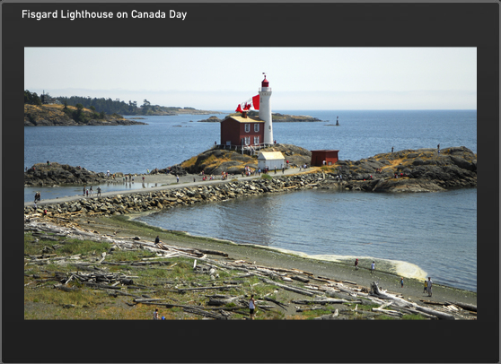


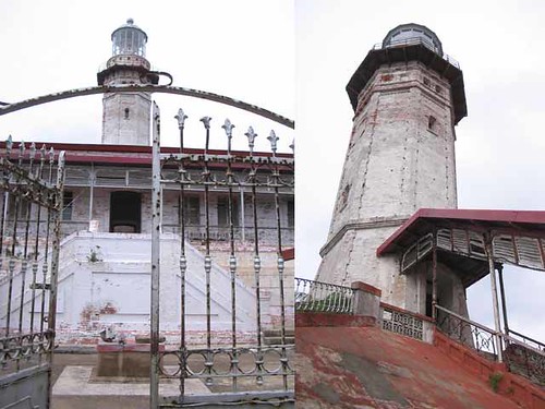
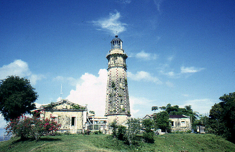


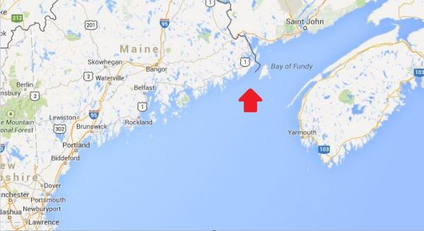
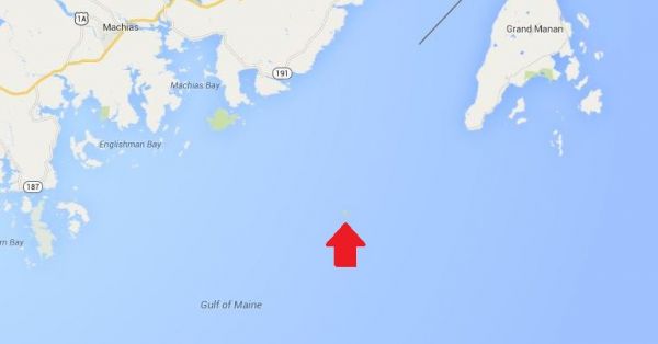
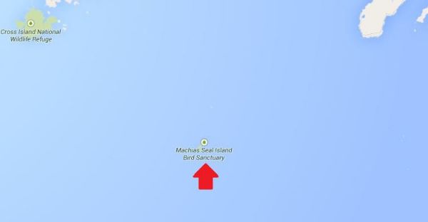
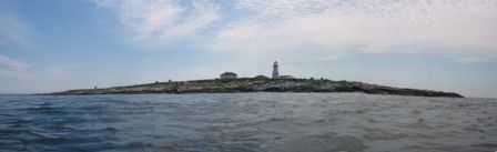
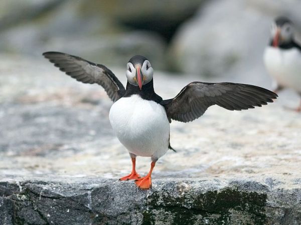

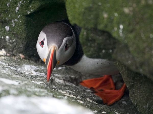


