Category Archives: Nova Scotia

Shine Bright Like A Lighthouse. A Love Affair With Maritime History.

Shine Bright Like A Lighthouse. A Love Affair With Maritime History.

John Sylvester, Country Magazine May 15, 2014
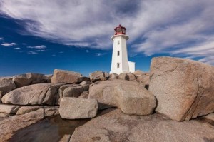
Peggy's Cove
Peggy’s Point Lighthouse (Photo: John Sylvester)

Having grown up in Nova Scotia, I have fond memories of scrambling over the curved granite whaleback rocks below my aunt’s cottage near the community of Peggy’s Cove.

Even though that’s the home of Nova Scotia’s most famous landmark, Peggy’s Point Lighthouse, I didn’t pay much attention to the lighthouse in those days. The tide pools and shallow caves of the whalebacks were more enticing. As an adult, however, I’ve grown to appreciate and cherish these beautiful beacons and the maritime tradition they represent. . . . more

See more photos and information under his story in Country Magazine called Lighthouse Preservation in Atlantic Coast Canada

Editor’s Note: Find additional information on Quebec, Newfoundland and Prince Edward Island lighthouses, along with ideas for exploring the surrounding towns, right here on our blog!

And be sure to read John Sylvester’s new eBook: A Photographer’s Guide to Prince Edward Island, a downloadable PDF for mobile devices, available at: www.photographersguidetopei.com.

[private]

As long as humans have sailed the oceans, we’ve needed navigational aids to warn of hidden shoals and dangerous headlands. The earliest warning lights were coastal bonfires. The first known lighthouse was built at Alexandria, Egypt, around 280 B.C. The British built North America’s first one at the entrance to Boston Harbor in 1716. The French ­followed 15 years later with Canada’s first lighthouse near their fortress at ­Louisbourg on what is now Nova Scotia’s Cape Breton Island.
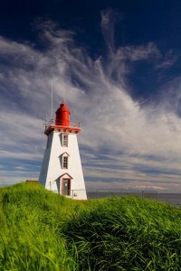
John Sylvester_01
Peggy’s Point Lighthouse (Photo: John Sylvester)

In sailing’s golden age, from the 1700s to the mid-19th century, lighthouses proliferated along the Atlantic coast. In Atlantic Canada alone, nearly 500 still stand along 33,000 miles of mainland and island coastline. A few miles up the coast from Peggy’s Cove, North America’s oldest continuously operating light, Sambro Island Lighthouse, stands on a tiny granite outcrop at the entrance to Halifax Harbor. Built in 1758, its eye-catching 80-foot red-and-white tower has been the first sign of land seen by countless sailors, immigrants and ocean liner passengers—including the Titanic survivors—as they approached the safety of landfall.

During the heyday of maritime activity, lighthouse keepers and their families lived in homes either attached to or close by the lighthouse. They often had to fend for themselves in isolated circumstances, growing a garden and raising livestock in addition to their full-time duties tending the light. Every evening, in fair weather or foul, the light keeper climbed a narrow, winding staircase to the top of the tower to light the lamp, located behind a powerful Fresnel lens that magnified and ­transmitted the beam far out to sea.

Light keepers eventually lost their jobs to automation, and in recent years sophisticated GPS navigation systems have rendered lighthouses redundant. Some have fallen into disrepair, but many have been rescued by local preservation or historical societies and converted into museums or tourist attractions.

Thanks to broad grassroots support, the federal government passed an act encouraging lighthouse preservation. But Natalie Bull, executive director of Heritage Canada The National Trust, notes that the legislation ultimately says it’s up to communities to protect their lighthouses.
John Sylvester_02
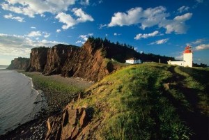
Bay of Fundy Lighthouse (Photo: John Sylvester)

“It’s very challenging, but residents of the Maritime Provinces are resourceful,” she adds. “Community groups have long been willing to take on these preservation projects, even before the act passed. New Brunswick’s Cape Enrage Lighthouse is a great example.”

The Cape Enrage keepers house was slated to be torn down when, in 1993, a group of local high school kids and their physics teacher started renovating it. Two years later the Coast Guard transfered ownership to the province, and the site is now the hub of a thriving adventure tourism destination that includes kayaking, rock climbing and horseback riding.

The wonderful thing about lighthouses, of course, is that they’re invariably built on beautiful coastal stretches. Some have been converted into inns where you can rent a room overlooking the ocean, listen to the waves lapping the shore and imagine life in a bygone era. You can now find lighthouse inns in all five of the provinces on Canada’s Atlantic Coast.
John Sylvester_03
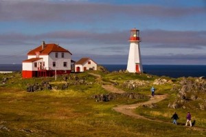
Quirpon Island Lighthouse (Photo: John Sylvester)

A few years ago I clambered into a small fishing boat that transported me to remote Quirpon Island off the north coast of Newfoundland, where I stayed in a cozy inn that was a former light keeper’s cottage. I spent two glorious days exploring the island, watching whales and sculpted icebergs drift by, and being pampered with Newfoundland’s renowned hospitality.

But even when I can’t spend the night, I rarely pass up a chance to visit one of these inviting beacons. On a recent trip to Nova Scotia, my wife and I drove out to Peggy’s Point Lighthouse on a beautiful autumn day. We joined tourists from all over the world wandering among the same whaleback rocks that fascinated me as a child.

We lingered through the afternoon, enjoying the timeless wonder of waves breaking on the rocks and sunlight sparkling off the ocean while one of Canada’s most beloved symbols of a proud seafaring tradition stood watch. And this time, I knew enough to appreciate it.

John Sylvester is an author and photographer based in Prince Edward Island, Canada. He specializes in photographing the people and places of Canada, and has published extensively on the Atlantic region, including the great lighthouses.
John Sylvester_04
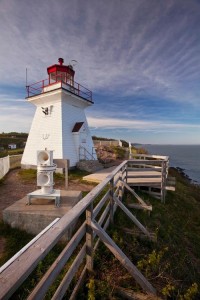
Cape d’Or Lighthouse (Photo: John Sylvester)


John Sylvester_05
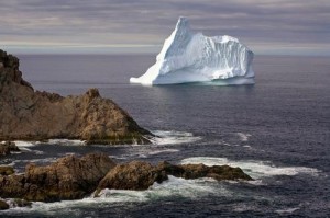
An ice flow off Newfoundland (Photo: John Sylvester)


John Sylvester_06
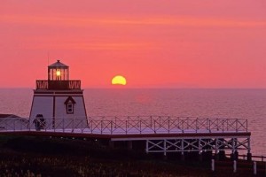
Sunset at Fortune Head Lighthouse (Photo: John Sylvester)

[nggallery id=96]

[/private]

Two of the World’s Oldest Lighthouses

Under the title Can you shed light on it? by the Grimsby Telegraph and posted: on May 01, 2014 Tim Mickleburgh said:

The world’s oldest lighthouse (the Pharos of Alexandria) was built by Sostratus of Cnidus around 270 BC.

Spurn
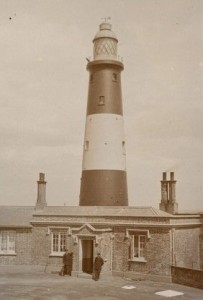
The oldest UK lighthouse? The lighthouse and lightkeeper’s house at Spurn.

It was a pyramid-shaped tower of white marble on the island of Pharos (in Greek the word Pharos means lighthouse) off the coast of Alexandria, Egypt.

It was estimated to be 400ft tall, and was one of the Seven Wonders of the World, a listing designated by Antipater of Sidon in the second century BC.

This formed part of Alexander’s Harbour, Alexander being of course Alexander the Great.

Alas, the lighthouse was destroyed by an earthquake in 1375 AD.

Unfortunately, the Guinness Book Of Records never provided a listing for the oldest British lighthouse. – read more

*****************************

The oldest lighthouse in my home country of Canada was built in 1713 and went into service at the French fortress of Louisbourg on Cape Breton Island in 1734.

What is the name and location of the oldest lighthouse in your country? Write me a note and let me know and I will post it here.

[private]

THE world’s oldest lighthouse was built by Sostratus of Cnidus around 270 BC, writes Tim Mickleburgh.

It was a pyramid-shaped tower of white marble on the island of Pharos (in Greek the word Pharos means lighthouse) off the coast of Alexandria, Egypt.

It was estimated to be 400ft tall, and was one of the Seven Wonders of the World, a listing designated by Antipater of Sidon in the second century BC.

This formed part of Alexander’s Harbour, Alexander being of course Alexander the Great.

Alas, the lighthouse was destroyed by an earthquake in 1375 AD.

Unfortunately, the Guinness Book Of Records never provided a listing for the oldest British lighthouse.

So when this came up as a quiz question recently, I was stumped, expressing ignorance when the answer was given as Spurn Head.

This though set me to do some private research.

Fortunately I have the book written by Kenneth E Hartley and Howard M Frost, The Spurn Head Railway (Second Edition 1988). It gives reference to a hermit named Reedbarrow being responsible for erecting a lighthouse in c1427, going on to state that “following the unrecorded disappearance of Reedbarrow’s early lighthouse a London man, Justinian Angel, erected a lighthouse at Spurn during the years 1673-4”. There is no claim however that the lighthouse was Britain’s first.

So I then turned to Lynn F Pearson’s Piers And Other Seaside Architecture (Second Edition 2011) for enlightenment. But it wasn’t to be, as lighthouses don’t feature within its pages.

The AA Book Of The Seaside (1972) is of more help, telling readers that only 11 lighthouses existed by the 17th century, all on the south coast. It adds that the Roman Pharos in Dover castle was “one of the earliest surviving examples … from this dim brazier … lighthouses have slowly developed”.

This though presumably wasn’t a standalone building, unlike that at Spurn Head.

Thus I await further information from amongst your erudite readership!

Do you know which is Britain’s oldest lighthouse? If you can help, then please write to Bygones, Grimsby Telegraph, 80 Cleethorpe Road, Grimsby, North East Lincolnshire DN31 3EH or you can e-mail bygones@grimsbytelegraph.co.uk

[/private]

Machias Seal Island – An Ongoing Border Dispute Between the United States and Canada

I have mentioned Machias Seal Island before in my articles here, here, here, and here.

Well writer John Farrier published on Neatorama on Tuesday, April 22, 2014 a great article about how MAJOR/insignificant this dispute really is!

1398212464-0

(Maps: Google Maps)

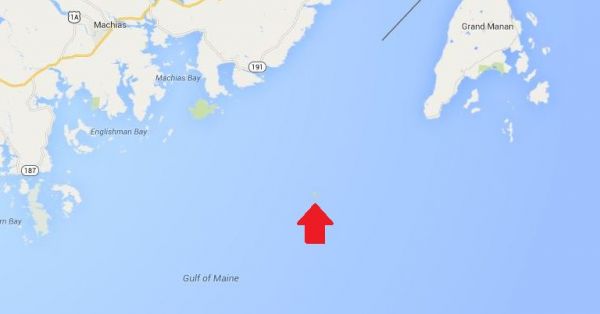
This is Machias Seal Island, a 20-acre island in the Bay of Fundy.

You can’t see it? Let’s zoom in.

And from there the story continues! Such an insignificant island for such a big debate. That is government for you. Naturally it belongs to Canada! . . . more

[private]

1398212464-1

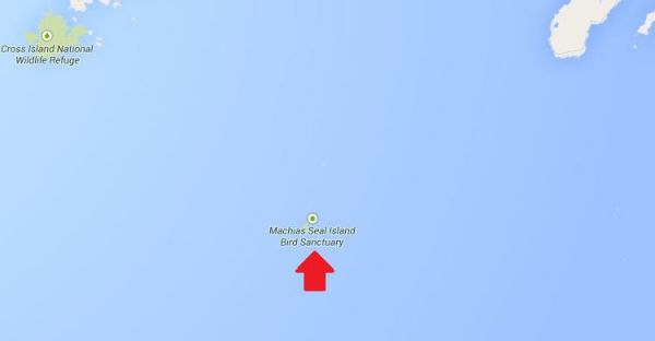
Hmm. That doesn’t help much. Let’s zoom in some more.
1398212874-0

There it is! It’s a speck of land that barely appears on the map.

1398212874-1
(Photo: Albnd)

You can see the lighthouse in the photo above. The island is inhabited by 2 human lighthouse keepers, a few seals…

1398212874-2

(Photo: Thomas O’Neil)

…and lots and lots of puffins.

The ownership of Machias Seal Island is disputed by the United States and Canada. Canada is in physical possession of it, but the United States has not formally dropped its claim to the island.

I’ve previously written several posts about the development of the US-Canadian border, whichincludes weird exclaves. Ambiguity about the border even led to the creation of 2 short-lived nations.

1398213788-0

(Painting by Benjamin West of the American delegation at the Treaty of Paris)

Although the United States and Canada now maintain a long, peaceful border, the placement of that border has been in doubt since the Treaty of Paris (1783) in which Britain recognized the United States as an independent nation. That treaty attempted to draw borders over unexplored lands. The authors did the best that they could with their knowledge of geography. But, alas, one of the descriptions for the border between Maine and maritime Canada was problematic. The treaty says that US territory includes:

all Islands within twenty Leagues of any Part of the Shores of the United States, and lying between Lines to be drawn due East from the Points where the aforesaid Boundaries between Nova Scotia on the one Part and East Florida on the other shall, respectively, touch the Bay of Fundy and the Atlantic Ocean, excepting such Islands as now are or heretofore have been within the limits of the said Province of Nova Scotia.

I’ve bolded the parts of the text that are the source for the Machias Seal Island dispute.

As I’ve mentioned in a previous post, the eastern border of Maine was of great concern to the British. Some British officials coveted what Americans saw as their territory, and vice versa. Control of the Bay of Fundy was of great importance to British commissioners at the Treaty of Ghent (1814), which ended the War of 1812.

1398215328-0

(Photo: Thomas O’Neil)

Now back to Machias Seal Island. The American argument is that it lies within 20 leagues (approximately 69 miles) of the coast of the United States.

The Canadian argument is that a land grant that pre-exists the Treaty of Paris defines the island as part of Nova Scotia. It built and has operated a lighthouse on the island since 1832.

Occasionally fishermen from the 2 nations have gotten into scraps about its ownership. Some Canadian citizens have staked mining claims to the island as a means of asserting Canadian sovereignty. The State of Maine has included the island on its maps of electoral districts.

But if possession is indeed 9/10ths of the law, then Machias Seal Island is Canadian. The United States has chosen not to press the issue.

Sources:
Clark, Edie. “Barna Norton Invades Canada.” Yankee 62.6 (1998): 48. Biography Reference Bank (H.W. Wilson). Web. 22 Apr. 2014.

Guo, Rongxing. Territorial Disputes and Resource Management: A Sourcebook. New York: Nova Science Publishers, 2007. Web. Google Books. 22 Apr. 2014.

Kelly, Stephen R. “Good Neighbors, Bad Border.” New York Times, Late Edition (East Coast) ed. Nov 27 2012. ProQuest. Web. 22 Apr. 2014 .

RELATED NEATORAMA POSTS

[/private]


Chris Mills – Canadian Lighthouse Photographs


Canadian Lighthouse Photographs

New website is coming.
http://www3.ns.sympatico.ca/ketm/
is no longer online


Chris Mills
1121 Ketch Harbour Rd.
Ketch Harbour, Nova Scotia  B3V 1K7


British Columbia | Nova Scotia | Prince Edward Island | New Brunswick | Newfoundland

Chris Mills served as a lighthouse keeper for the Canadian Coast Guard on both the Atlantic and Pacific coasts.

He is currently co-chair of a committee which is recruiting Members of Parliament in support of a private members bill to protect lighthouses.  To see how you can help, visit this site:  Canada Needs a Lighthouse Protection Act.

Photographs and enlargements are for sale. Contact Chris Mills for price information.
All photographs and slides in the collection are identified, dated and signed.

Chris Mills is also author of the book on Nova Scotia lighthouses Lighthouse Legacies available from Amazon.ca


Sambro Island restoration project


BRITISH COLUMBIA

Some of these photos may be viewed at the Lighthouses of British Columbia site.

Green Island (1994, 1995) 250 colour photos, 70 colour slides in collection. All aspects of the station and island documented — aerial views, sea views, night views, details of light and lighthouse, lightkeepers, Coast Guard helicopters, surrounding islands and seascapes.


Langara Island (1994, 1996) 250 colour and 25 black and white photos, 180 colour slides in collection. All aspects of station documented — aerial views, night views, detailed views of 1913 First Order Fresnel Lens (manufactured by Chance Brothers), light tower and lantern, lightkeepers, dwellings, interior of engine room, old cabin on island, face carved in tree, shoreline views, lightkeeper’s goats, stormy seas.


Triple Island (1994) 24 colour photos in collection. Aerial views, third order Fresnel lens, lightkeeper, detailed views of lighthouse structure, interior of workshop and engine room.


Bonilla Island (1994) 250 colour photos in collection. Many aspects of station — aerial views, sea views, night views, shoreline views (including Japanese glass fishing floats), lightkeepers, dwellings, engine room interior, light tower. (NOTE: this collection will be expanded during Sept/Oct 1996)


Boat Bluff (1994-1996) 160 colour photos in collection. All aspects of station — aerial views, sea views, night views, details of light tower, fog horns , engine room, main light (including views of keeper inspecting light at night, inspection of light and bulbs during day), views of station and mountains from 1000 foot hill across the channel from lightstation, snow views, old hand fog horn, three modern plastic lenses, sunrise views, surrounding bays and inlets, Santa and Mrs. Claus visit 1994. (NOTE: Available as of Dec. 1996 — selection of a further 200 colour and b&w prints taken during August 1996, including Coast Guard ship and work crews supplying station.)


Ivory Island (1994-1996) 600+ colour and 36 black and white photos, 100 colour slides in collection. All aspects of the lightstation — 30 aerial views, sea views, night views, lighthouse, keepers, dwellings inside and out, engine room, main light, surrounding area, beaches, salmon fishing, snow, totem poles, artist and photographer at work at the lightstation, Coast Guard helicopters, sunsets, shoreline and forest, various tidal life (sea stars, crabs, etc.), local minor beacon lights, 25th annual Santa and Mrs. Claus visit December 1995.


McInnes Island (1994, 1995) 48 colour photos, 22 colour slides in collection. Aerial views, lighthouse structure, radio room, keeper, detail of lantern and main light, large thunder cloud formations.


Dryad Point (1995) 32 colour photos in collection. Aerial views, light tower, main light, keeper and daughter, keeper and main light, dwelling. (NOTE: This collection will be expanded during 1997)


Addenbroke Island (1994) 14 colour photos in collection. Aerial views.


Egg Island (1994) 10 colour photos in collection. Aerial views.


Pine Island (1994) 3 colour photos in collection. Aerial views.


Scarlett Point (1994) 2 colour photos. Aerial views.


Point Atkinson (1994) 14 black and white photos in collection. Light tower, keeper and main light, station dwellings and exterior of radio/engine room.


Brockton Point (1994) 5 black and white photos in collection. Light tower.


Porlier Pass (1994) 32 colour photos in collection. Two light towers (Porlier is a range light station), main lights, boat and boathouse, lightkeeper, dwelling, interior engine room and fog horn building, Coast Guard hovercraft. (NOTE: The old front range light was demolished Feb. 1996 and replaced by a fibreglass tower and the lighthouse was automated shortly after.)


Fisgard (1994) 6 colour, 2 black and white photos in collection. Light tower and detail of gothic style window in old keepers dwelling.


Sheringham Point (1994, 1995) 20 colour photos in collection. Light tower, abandoned dwelling, sunset, old Fresnel lens at local museum.


Amphitrite Point (1995) 9 colour slides in collection (prints available). Lighthouse structure, old keepers dwelling.


Lennard Island (1995) 52 colour photos, 25 colour slides in collection. Traveling to island by boat, keeper in boat, keeper in lighthouse, keeper and wife on station grounds, dwellings, radio room, engine room, details of two fog horn systems, including traditional diaphone horn taken out of service Oct. 1995, light tower, station grounds.


Cape Scott (1996) 23 colour photos in collection. Aerial views.

NOVA SCOTIA

Some of these photos may be viewed at the Nova Scotia Lighthouse Preservation Society site.

Baccaro Point
Bear River
Beaver Island
Black Rock Point
 (new lighthouse)

Black Rock Point (old lighthouse)
Boar’s Head
Brier Island
Cape Forchu
Cape George
Cape Sable
Chebucto Head
Fort Point
 (LaHave River)

Fort Point (Liverpool)
Fourchu Head
Gabarus
George’s Island
Grand Passage
Hampton
 (Chute Cove)

Horton Bluff
Jerome Pont
Louisbourg
Low Point
Maugher’s Beach
Medway Head
Peggy’s Cove
Point Aconi
Port Greville
 (old light, now at Canadian Coast Guard College, Point Edward, N.S.)

Port Medway
Prim Point
Rouse Point
Sable Island
 (east light)

Sable Island (west light)
Sambro Island
Scatarie Island
Schafner Point
Seal Island
Sydney Range
 (front light)

Sydney Range (rear light)
Western Head
Battery Point
Betty’s Island
Canso Locks
Cross Island
 (comprehensive collection including automation day)

Eddy Point
Mosher’s Island
Seal Island
 (comprehensive collection)

Seal Island Lighthouse Museum

PRINCE EDWARD ISLAND

Blockhouse Point
Borden Range
 (front light)

Borden Range (rear light)
Cape Bear
Cape Tryon
Brighton Beach Range
 (front light)

Brighton Beach Range (rear light)
East Point
Murray Harbour Range
 (front light)

New London Range (rear light)
North Rustico
Panmure Island
Point Prim
Souris East
Summerside Range
 (front light)

Summerside Range (rear light)
Woods Islands
Woods Islands Range
 (front light)

Woods Islands Range (rear light)

NEW BRUNSWICK

Cape Spencer
Cape Tormentine
Fish Fluke Point
 (Grand Harbour)

Gannet Rock (comprehensive collection: 700+ prints and slides)
Great Duck Island
East Quoddy
 (Head Harbour)

Letite
Long Eddy
Long Point
Machias Seal Island
 (comprehensive collection)

Mulholland Point
Southwest Head
Swallowtail

NEWFOUNDLAND

Cape Anguille
Cape Ray
Cape Saint Francis
 (dwelling only)

Cape Saint Mary’s
Cape Spear
Lobster Cove Head
Rose Blanche
 (old stone lighthouse)

Books on BC Lighthouses

Over the years since I started this website in 2005 I have collected many books on British Columbia lighthouses. Some with only a reference to lighthouse, others dedicated exclusively to BC lighthouses like Donald Graham’s books.

Later I will dedicate a page to each book as I have to some earlier ones, but right now I am more interested in showing newcomers what is/was available so that they will recognize them when they are found in a flea market or garage sale.

If you click on the photo left, it will take you to a modified page from my old website which lists books that I have collected over the years. It will also specify if the book is available for sale or not.

Listed below are a few more lighthouse-related books that did not make it onto that list before I created this new website. If you can, please send me an email or comment about a new book that you have found. I will add it to the list and we can make this as complete as possible. Also, if possible, would you please also send a scan of the front cover so I can add it to the pages. You know the old saying “A picture is worth a thousand words”. Thank you.

Shipwrecks Along the West Coast Trail – Richard E. Wells – Sono Nis Press

Silent Seige III – Bert Webber – 301 pages – Webb Research Group (December 1992) 

The Last Island – Alison Watt – Harbour Publishing – 978-1-55017-296-6 · 1-55017-296-4
$34.95 · Hardback 6.5 x 9.5 · 192 pp · September 2002 (Available)
http://www.harbourpublishing.com/title/TheLastIsland
ISBN-10: 0936738731, 10.7 x 8.3 x 0.9 inches

There’s A Landing Today – Richard E. Wells – Sono Nis press