Doug is a professional artist, videographer and photographer. He is a lifetime resident of Victoria and has been capturing its beauty on film for over 30 years. – from the Facebook page
In my teenage years while attending High School and University, and before I moved onto the lighthouses, I lived in Victoria, British Columbia (BC), Canada (on southern Vancouver Island off the West Coast of BC). It was a delightful town to grow up in and had access to numerous beaches, parks and believe it or not, a few lighthouses, of which I was not interested at that time.
Just recently on Facebook I have seen some wonderful photography of the lighthouses in and around Victoria, BC by Doug Clement. He has given me permission to publish them here, I hope that in your first or next trip to Victoria, you get a chance to see these places. If not, please admire them in the photos by Doug Clement.
The first photo above shows Trial Island Lighthouse at night with a blast of lightning. The actual light of the lighthouse is the greenish glow on the right side while the red lights are warning lights for aircraft mounted on the radio towers on the island (see the last photo in this story).
When I wrote Recycling Glass as Sea Glass aka Mermaids TearsI never realized that keepers on one of the BC lighthouses, Nootka Island Lighthouse (photo above) were utilizing this free resource for jewelry.
They have a Facebook page showing some of the items for sale, some of which I am showing below. Very beautiful. My uses for the sea glass were a bit more mundane, but it is amazing what you can make with beach glass, sea glass, aka mermaid’s tears.
I also see that the keepers are also advertising their wares on Etsy – a very famous site for anything coastal.
[nggallery id=73]
There are lots more items than shown in the album above, so take a look at their Facebook page or the Etsy pages – very beautiful art work, and each is unique.
Would you like to travel to Nootka Island to visit the keepers or pick out your own jewelry? Join the MV Uchuck III on a day tour to Nootka Sound. More information here.
The West Coast Trail is a 75 km (47 mi) long backpacking trail following the southwestern edge of Vancouver Island in British Columbia, Canada. It was built in 1907 to facilitate the rescue of survivors of shipwrecks along the coast, part of the treacherous Graveyard of the Pacific. It is now part of Pacific Rim National Park (Parks Canada and Wikipedia) and is often rated by hiking guides as one of the world’s top hiking trails.
The West Coast Trail is open from May 1 until September 30. It is accessible to hikers outside of this period but Parks Canada does not guarantee the accessibility of services (such as search and rescue) in the off season. It was originally known as the Dominion Lifesaving Trail (sometimes misidentified as the West Coast Lifesaving Trail).-Wikipedia
My daughter and her friend just finished hiking the West Coast Trail this Summer 2013 and thoroughly enjoyed it. (photos on Facebook) It is rough, it is challenging, but it is an adventure, and it is fun! The trail passes by two manned lighthouses (Pachena -photo above, and Carmanah – photo below) which date back to the time when the trail was Continue reading The West Coast Trail→
Documentary Film about the Great Bear Rainforest Youth Paddle – www.gbryouthpaddle.org
In June 2012, a group of Quest university students travelled to the Great Bear Rainforest, through BC’s Inside Passage and arrived in the remote First Nations community of Hartley Bay. Here, we learned firsthand about the potential impacts of the Northern Gateway Pipeline proposal on Gitga’at culture and traditions. Quest students, along with youth from the Hartley Bay Secondary School, joined together on a life-changing journey through the pristine waters of BC’s temperate rainforest. Together we paddled from Hartley Bay to the Gitga’at’s spring-harvest camp in Kiel. We journeyed through a portion of the proposed tanker route for the Northern Gateway project, the same area where the ferry Queen of the North sank in 2006. Durig our time in Hartley Bay, participants bared witness to the unparalleled natural abundance of the Great Bear Rainforest. This short documentary provides a platform for youth to speak out and express their perspectives of the pipeline proposal. It also celebrates land and culture, while promotes a more sustainable future.
In 2012 I wrote an article called What Ship Is That? which listed a group of programs for tracking ships worldwide. Why would one want to do that? For myself I like to keep track of what ships are sailing on my home coast (the Philippines right now) or for that matter, on the British Columbia coast (my old workplace). It is interesting and informative to anyone that lives on or by the sea. The following story came in from CBC News:
Canadian firm tracks Earth’s ships from space Data mining with tiny satellites offers new business opportunities By Emily Chung, CBC News Posted: Aug 12, 2013 5:33 AM ET Last Updated: Aug 12, 2013 12:59 PM ET
ExactEarth’s data allows authorities to monitor whether ships are following maritime traffic laws or straying into protected areas. For example, it could have provided visual data on the Panamanian-registered ship MV Double Prosperity, which ran aground and destroyed a large portion of a marine sanctuary in Sarangani Bay in 2011. (Sarangani Information Office, Cocy Sexcion/Associated Press)
Want to know the location of every freighter and cruise ship plying the Earth’s oceans? That data isn’t easy to get, but a Canadian company can sell it to you, thanks to its view of the Earth from space.
Since 2010, Cambridge, Ont.-based exactEarth Ltd. has been “mining” data about shipping traffic on Earth using satellites — a technique that could potentially be used to collect other, new kinds of valuable data.
‘The ultimate goal is to build out a cluster of businesses around this platform.’—Glenn Smith, Communitech
“Until we started doing this…you had little bits of information, but you really didn’t have a complete domain awareness of what’s out there,” said Philip Miller, the company’s vice president of engineering and operations.
“Once a ship leaves the shore, essentially they’re a sovereign entity …. A captain can go where he wants. And from shore you didn’t know what was happening unless you contacted the ship and asked — whereas now we’re watching, and we know where they go.”
100,000 ships per day
ExactEarth sells information about the more than 100,000 ships it detects per day to over 50 customers on five continents, including ports, navies and governments.
The data can be used for a wide variety of applications, such as:
Identifying and tracking ship traffic through specific areas, such as the Arctic routes that are opening up as the sea ice melts
Monitoring whether ships are following maritime traffic laws or straying into protected areas
Detecting illegal fishing and piracy, or coordinating search-and-rescue operations during natural disasters.
Last year, the company doubled its customer base, doubled its revenues from $4.8 million to $9.6 million and had total order bookings of about $13.6 million, according to the 2012 financial report from its parent company, COM Dev, a satellite equipment maker that trades publicly on the Toronto Stock Exchange.
COM Dev predicted that by the end of 2013, exactEarth would become “a positive contributor to our cash flow.”
Not designed for detection from space
ExactEarth gets its marketable data by detecting over five million messages a day from automatic identification system (AIS) signals that passenger ships and ships over 300 tonnes (Class A vessels) are required to send out under international law.
The VHF radio signals, mandated by the International Maritime Authority since 2002 to reduce the risk of collisions, provide information about a vessel’s course, speed, position, size, destination and identification to nearby ships and monitoring and navigation stations. ExactEarth can also detect signals from some smaller vessels that use a lower-powered version of AIS.
ExactEarth detects five million messages a day from more than 100,000 ships around the world. (exactEarth)
AIS was designed for close-range communication and not for detection from space, Miller said.
But such detection was plausible — satellites have the ultimate bird’s eye view of Earth, without the obstructions that get in the way on the surface. Our eyes can spot thousands of car headlights and streetlights from an airplane, but with the right detectors, satellites in space can scan a wide area as they orbit and detect signals that have relatively short ranges on Earth.
Miller said ExactEarth started at a time when smaller satellites — suitcase-sized or smaller as opposed to car- or bus-sized — were starting to become more available and affordable. COM Dev began looking for things that it might be able to detect from space with such satellites, beyond traditional environmental monitoring and imaging.
In collaboration with the University of Toronto’s Institute for Aerospace Studies Space Flight Laboratory, the company launched a satellite in 2008 to prove it could detect AIS from space.
Glenn Smith of Communitech and Robert Zee of UTIAS Space Flight Laboratory hold a life-sized replica of a nanosatellite like one they will be launching in collaboration with exactEarth next year to provide more timely information about ships near the equator. (Emily Chung/CBC)
ExactEarth began commercial service in 2010, using satellite technology from other suppliers. It launched two additional satellites of its own in 2011 and 2012.
ExactEarth’s satellites aren’t the only AIS detectors in space — Rochelle Park, N.J.-based Orbcomm sells data subscriptions similar to ExactEarth’s and already has AIS satellites in both equatorial and polar orbit. Norway launched its AISSat-1 in 2010 and the German Aerospace Center DLR’s AISSat is scheduled to blast off on an Indian launcher later this year.
Miller said most AIS satellites process a lot more data on the satellite than exactEarth’s do, making them substantially different.
“By doing the processing on the ground, we cannot only do more processing, but we can also evolve it over time,” he said, adding that it’s difficult to change anything that’s already in space.
New kinds of data to mine
Some organizations are now interested in trying to mine other types of data from space.
Satellites like those launched by ExactEarth have the ultimate bird’s eye view of Earth, without the obstructions that get in the way on the surface. With the right detectors, they detect signals that have relatively short ranges on Earth, the way our eyes can spot thousands of car headlights and streetlights from an airplane. (ExactEarth)
For example, DLR is currently testing a satellite that detects aircraft signals called ADS-B, which are somewhat similar to AIS. If it works, it will allow continuous monitoring of aviation routes, including areas without radar stations, such as the poles, where airplanes are currently untrackable from the ground.
In Canada, the Waterloo Region’s startup incubator Communitech is collaborating with exactEarth and UTIAS on a project called Data.base, which aims to use exactEarth’s expertise to expand Canada’s “data mining from space” industry.
Research new applications and markets for the technology that exactEarth has developed to collect, package and view satellite data;
Work with other businesses that might be interested in getting into the area;
Improve the satellite technology; and
Design and develop new software.
“The ultimate goal is to build out a cluster of businesses around this platform,” said Glenn Smith, director of digital media projects management at Communitech.
Data.base thinks that AIS technology can be used outside the shipping agency to track other things. The technology to transfer data between Earth and space securely may be useful to industries such as finance, to transfer sensitive data from place to place on Earth via a satellite in space.
Smith said the group has already had discussions with a number of businesses and “there’s definitely a lot of interest.”
For its part of the collaboration, UTIAS is developing a new 15-kilogram microsatellite with a beefed-up power system that will produce and transmit more data more quickly, for both exactEarth and other companies doing similar work, said Robert Zee, managing director of the space flight lab.
Upcoming nanosatellite launch
Meanwhile, exactEarth wants to improve its detection of the weaker AIS signals of Class B ships and its ability to scan ships near the equator more frequently.
Currently, the company’s satellites are in polar orbit — in the same plane as the north and south poles — and can view only a small part of the equator each time they circle the Earth. That means there are “gaps of multiple hours” where ships near some areas of the equator will not be detected, Miller said.
To address that, exactEarth will launch a new seven-kilogram nanosatellite satellite, built by UTIAS, into orbit around the Earth’s equator. EV-9, which may incorporate some of the new technology that exactEarth is working on with its collaborators, will piggyback into space on the launch of a larger satellite. That launch was originally scheduled for this summer, but is now delayed until early 2014.
The new satellite will allow exactEarth to collect updated data about ships near the equator at least once per hour.
That will allow exactEarth to mine more data more quickly. But as in conventional mining, that’s just the first step.
It’s the refining of the data back on Earth that generates a marketable product that clients will pay for.
“You can collect all this data, and it’s valuable,” Miller said. “But you have to turn it into information and knowledge.”
AIS provides information about a vessels’ course, speed, position, size, destination and identification to nearby ships. ExactEarth can detect the AIS signals from space and use them to track individual ships, as in this data from Sept. 2011. (exactEarth) [/private]
Do you see the lighthouse? Is that not an impressive view!
The photo above was in a website for a Canadian west coast (Vancouver Island, British Columbia) resort. This is the actual view from one of the rooms. I could just imagine being there myself and seeing the waves beat up against the lighthouse island as I relaxed in comfort within the resort.
As I stated in my post The Lighthouse as a Sovereignty Symbol, put a lighthouse on your disputed territory and it is yours, or something to that effect. Now here is another ongoing dispute coming to light again – Canada vs USA. According to my theory above, Canada wins! – retlkpr
Posted: Dec 23, 2012 7:37 PM AT Last Updated: Dec 24, 2012 12:38 PM AT
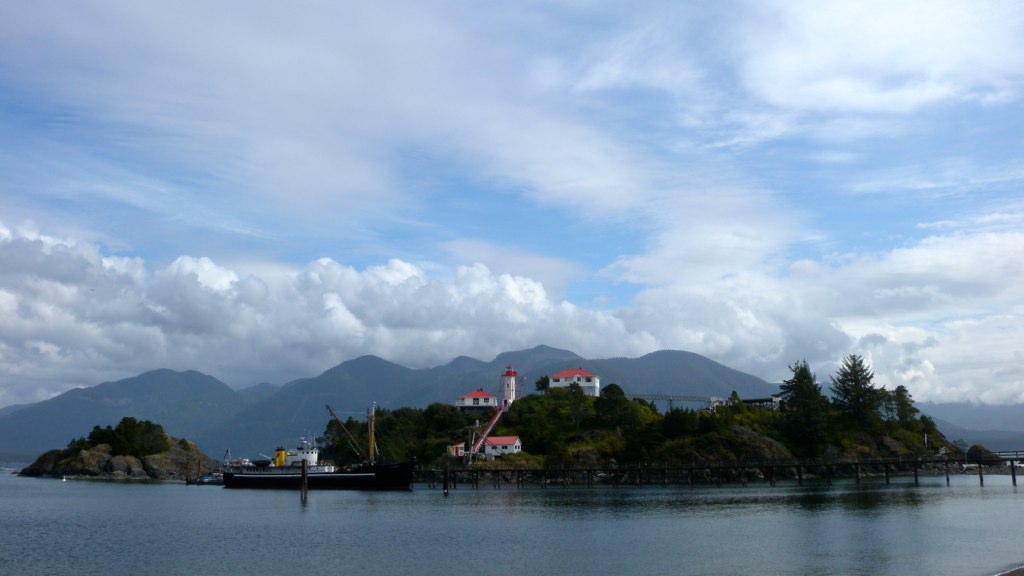
The Canadian flag flutters in the breeze by the lighthouse at Machias Seal Island. (Photograph by: Fred J. Field-The Canadian Press)
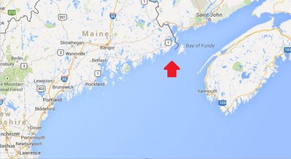
A tiny island between New Brunswick and Maine is the subject of renewed calls from both sides of the border to settle a territorial dispute once and for all.
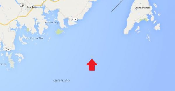
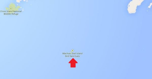
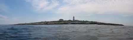
Machias Seal Island is a flat, treeless piece of rock located about 19 kilometres southwest of Grand Manan Island and east of Maine at the mouth of the Bay of Fundy.
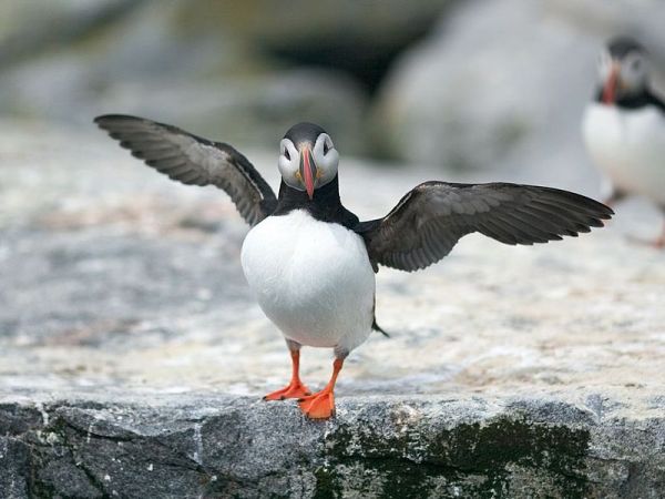
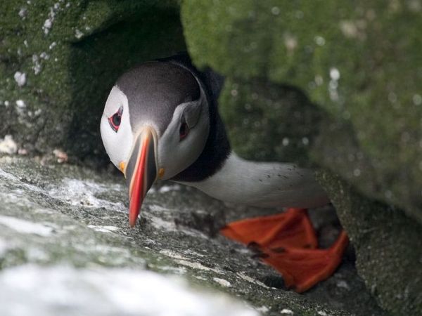
The island is a sanctuary for many kinds of seabirds including the Atlantic Puffin and draws visitors from around the world to observe them in the summer. more . . .
[private]
There are no permanent human residents on the island, just pairs of lightkeepers who spend 28 days at a time maintaining a lighthouse operated by the Canadian Coast Guard.
The original lighthouse was built by the British in 1832, and a lighthouse has been maintained there ever since.
So why would anyone even care which country gets title to Machias Seal Island?
‘Wouldn’t we feel silly?’ The answer lies in the 720 square kilometres of water around the island in what’s called a grey zone. Lobster fishermen from both Canada and the U.S. fish these waters.
“The fishing community on Grand Manan is permitted to fish there on an open-end basis and it’s our way of laying our claim to this water that is part of the Machias Seal Island dispute,” said MP John Williamson, who represents the riding of New Brunswick-Southwest.
Williamson said the island is considered to be in his riding.
‘I think our claim is sound and is legitimate.’ —MPJohn Williamson “I think our claim is sound and is legitimate, but at the end of the day it’s going to come down to the minister in this country and the administration in Washington to settle it,” he said. “I think it is in the interests of both of our countries to do that.”
That feeling is echoed by Stephen Kelly, a professor at the Center for Canadian Studies at Duke University and a retired American diplomat who has served in Canada.
“It just strikes me if we have this opportunity to remove a potential irritant going forward, why don’t we take it?” Kelly said in an interview from his office in Durham, N.C.
Kelly put his thoughts in a commentary for The New York Times last month, which he said he was prompted to write after seeing territorial disputes that have erupted between Japan and China over uninhabited islands in the East China Sea.
He said while the situation between Canada and the United States is much different, land disputes are better settled.
“What if some valuable resource is discovered in the grey zone around Machias Seal Island? What if some other contingency that we can’t imagine now of strategic importance comes along?” he asked.
“Wouldn’t we feel silly that we didn’t take the opportunity to resolve this when the stakes were relatively low.”
Irrelevant for lightkeeper
For Ralph Eldridge, a Canadian who has been a lightkeeper on the island for the last 16 years, the question of who owns Machias Seal Island is a “non-issue,” something that is never a question from the visitors who travel to the island each summer.
And Eldridge said he doesn’t have to produce his passport to go there.
“But neither does someone from the United States or China or Japan or Spain have to when they come to the island,” he said.
A spokeswoman for the Department of Foreign Affairs and International Trade said ownership of the island and surrounding waters is clear as far as Canada is concerned: they are Canadian.
“Canada’s sovereignty over Machias Seal Island and sovereign jurisdiction over the 210 square nautical mile surrounding waters is strongly founded in international law,” Barbara Harvey said in a statement.
[/private]
***********************************
[private]
In the Media Op-Ed: Canada and US dispute ownership of small rocky island Digital Journal By Ken Hanly Dec 25, 2012 in World
Tourist comes to Machias Seal Island during the summer to see birds such as the Atlantic Puffin.
Machias Seal Island is a tiny rock island 16 kilometres from the coast of the US state of Maine and 19 kilometers south of Grand Manan Island just off the coast of the Canadian province of New Brunswick. The island is claimed by both Canada and the US.
Machias Seal Island has an area of just 8 hectares or about 20 acres. The island is a sanctuary for many seabirds including the Atlantic Puffin seen in the appended video. Visitors from around the world come to view the birds during the summer. There are no permanent residents of the island although there are lighthouse keepers who come in pairs and stay four weeks at a time. The lighthouse is operated by the Canadian Coast Guard. The original lighthouse was built by the British in 1832. There has been a lighthouse maintained ever since. Many think that the presence of the lighthouse will give Canada a legitimate claim to the island. The United States has never had a presence on the island except in 1918 during the First World War when a small detachment of marines was posted to the island with Canadian agreement.
However in the past private citizens in Maine have claimed ownership of the island. There is a tour boat operator from Cutler Maine, who brings tourists to the island in the summer to view the birds. While there has been no oil or mineral resources discovered in the area, there is a large 720 square kilometres around the island called a grey zone. Lobster fishermen from both Canada and the US fish this area.
MP for New Brunswick Southwest , John Williamson said: “The fishing community on Grand Manan is permitted to fish there on an open-end basis and it’s our way of laying our claim to this water that is part of the Machias Seal Island dispute.I think our claim is sound and is legitimate, but at the end of the day it’s going to come down to the minister in this country and the administration in Washington to settle it. I think it is in the interests of both of our countries to do that.”
Unfortunately an earlier decision of a joint commission in 1817 did not decide the ownership of Machias Sea Island even though it did decide that of other islands in the area including Moose, Dudley, and Fredericks Islands that are now owned by the US and also Grand Manan island that now belongs to Canada.
Stephen Kelly of Duke University and a retired US diplomat thinks that it would be a good idea to resolve the issue.
“It just strikes me if we have this opportunity to remove a potential irritant going forward, why don’t we take it. What if some valuable resource is discovered in the grey zone around Machias Seal Island? What if some other contingency that we can’t imagine now of strategic importance comes along?Wouldn’t we feel silly that we didn’t take the opportunity to resolve this when the stakes were relatively low.”
Ralph Edlridge, who has been a light-keeper on the island for 16 years, thought ownership was a non-issue. Neither he nor anyone else who comes to visit the island has to worry about showing a passport whether they come from Maine, Canada, China, or Spain he said. Barbara Harvey a spokesperson for Foreign Affairs and International Trade said that as far as Canada is concerned the island is Canadian: “Canada’s sovereignty over Machias Seal Island and sovereign jurisdiction over the 210 square nautical mile surrounding waters is strongly founded in international law.” Some residents of Maine may not agree.
This opinion article was written by an independent writer. The opinions and views expressed herein are those of the author and are not necessarily intended to reflect those of DigitalJournal.com
Along the border of the Canadian province of New Brunswick and the American state of Maine sits a small rocky island caught between the two countries.
An almost endless number of headlines have been made in recent months over the (at times heated) conflict between Japan and China over the ownership of a small group of islands in the East China Sea.
Due to the nature of islands, often found along inexact maritime boundaries, ownership disputes are not uncommon – but few of them tend to make headlines. A recent article has shone a spotlight on one of these lesser-known tales, involving a lighthouse isle along the Canada/USA border.
Found at the mouth of the Bay of Fundy, Machias Seal Island is an unassuming rocky outcropping of less than 20 acres, with only a lighthouse tower and outbuildings raised above its flat, barren surface. This modest appearance may be why the island was overlooked during the latter part of the 18th century, when Britain and the newly-formed United States were defining their territorial boundaries. Surprisingly, the intervening centuries have done little to resolve the question of just who owns the island.
While the dispute over Machias Seal Island has remained a friendly one, it has heated up in recent decades. Unlike in the case of Japan and China’s battle over the Diaoyu/Senkaku archipelago, there are no rich offshore oil and gas reserves at stake, however, there is a vibrant lobster fishing industry in the indeterminate “grey zone” of the surrounding waters.
Image of island’s lighthouse from www.ccg.gc.ca
“It’s very congested,” said the head of local fisherman’s association. “It’s a very hard area to fish. The Americans think it’s theirs; the Canadians think it’s theirs, and nobody gets along all that well.”
Canada has, thus far, maintained the upper hand in the conflict – despite an elimination of full-time staff from lighthouses on the East Coast to cut costs, the building on Machias Seal Island bears the distinction of being the sole remaining non-automatic lighthouse in the region, a contiguous occupation that stretches back two centuries.
The Department of Foreign Affairs has been willing to foot the Coast Guard’s bill for the live-in staff, giving only the explanation that it is for “sovereignty purposes”.
The Chinese are at it. The Japanese are at it. The Brits and the Argentines are at it – all squabbling over small islands. There is even speculation that the US and Canada will revive their long-running dispute over little Machias Seal Island.
When large states are feeling small, it seems, small islands loom large. This is true not just of tiny, uninhabited outcrops. Independent and semi-independent islands are in the limelight too.
One reason for this is clear. Entitled to many of the same rights as large states, but without the same responsibilities, these islands pose an outrageous challenge to the international order and need to be brought back under control.
It is not just their tax practices, although this is the issue that currently defines the EU’s agenda. By selling passports to anyone passing, islands help criminals change identities and travel the globe undetected. And by conferring diplomatic recognition upon renegade countries, islands endanger global security.
There is a second reason too: entitled to many of the same rights as larger states, but without the same responsibilities, small islands are an outrageous challenge to the international order, and are therefore extremely useful allies to big countries.
Thanks to the competition caused by their tax regimes, small islands can be helpful to large countries wishing to impose fiscal discipline upon their partners or just hoping to excuse their own tax practices. And by handing out passports to all-comers, islands can ‘liberate’ the business elites and political opposition of repressive regimes – saving big states the need to intervene.
Small islands are even credited with a diplomatic daring which larger countries cannot afford to practice. Fearful of encouraging secessionist tendencies at home or of antagonising their international partners, large states are often too nervous to recognise breakaway countries. Small islands go where large states fear to tread.
This ambiguous status in an international system made for big players gives islands a significance quite disproportionate to their size. Take for instance Nauru (population: 9,000; size: 21 square kilometres; distinguishing features: looks from above suspiciously like a treasure island).
For years, China and Taiwan were locked in competition for Nauru’s diplomatic loyalty, with Nauru reportedly allowing itself to be bought first by one side then the other. Indeed, in 2002, when the Taiwanese president rocked the world by supporting a referendum on independence, his move was viewed as a reaction to Nauru’s sudden switch of loyalties to the People’s Republic.
The case of Nauru also shows how quickly islands can go from international pariahs to valued partners, depending on large states’ whims. In 2003, the US appears to have decided that the Nauruans’ passport-for-sale scheme was not a danger to international security after all. Just the opposite in fact: it offered a means to smuggle nuclear scientists out of North Korea. If reports are true, Nauru, the one-time bandit, suddenly found itself made deputy sheriff.
This special attitude towards islands – an attitude which does not seem to pertain to other small states – reflects the strong hold they exercise over the popular imagination. Blame that Christmas favourite, Treasure Island. For people living a routine mainland life, islands signify pirates or palm trees: they are either dangerous or alluring.
At one extreme are the harmless bores who view islands as a serious threat to international security and stability, can recite by heart the guidelines on good governance produced with a cheerful lack of irony by the EU, OECD or G20, and show an unhealthy interest in all forms of small-island deviance.
At the other are the escapists who see islands as an alluring alternative to mainland life and who secretly dream of seizing a rocky outcrop and establishing a libertarian utopia of their own.
Islands are thus either ‘unviable’ – incapable of sustaining themselves without cheating on big states, and ripe for depopulation – or an escape – ripe for repopulation by mainlanders. Acknowledging instead that islands are in fact entities in their own right, capable of responsible self-regulation – within the same context of global interdependence that affects all countries – might help avoid unfortunate situations like Nauru’s.
After all, if the reports about 2003’s ‘Operation Weasel’ are accurate, Nauru’s citizens had just succeeded in stopping their government from selling passports on grounds of good governance, only to see the US reintroduce the practice for them.
The ownership of Machias Seal Island is disputed by the United States and Canada. Canada is in physical possession of it, but the United States has not formally dropped its claim to the island.
I’ve previously written several posts about the development of the US-Canadian border, whichincludesweirdexclaves. Ambiguity about the border even led to the creation of 2 short-lived nations.
(Painting by Benjamin West of the American delegation at the Treaty of Paris)
Although the United States and Canada now maintain a long, peaceful border, the placement of that border has been in doubt since the Treaty of Paris (1783) in which Britain recognized the United States as an independent nation. That treaty attempted to draw borders over unexplored lands. The authors did the best that they could with their knowledge of geography. But, alas, one of the descriptions for the border between Maine and maritime Canada was problematic. The treaty says that US territory includes:
all Islands within twenty Leagues of any Part of the Shores of the United States, and lying between Lines to be drawn due East from the Points where the aforesaid Boundaries between Nova Scotia on the one Part and East Florida on the other shall, respectively, touch the Bay of Fundy and the Atlantic Ocean, excepting such Islands as now are or heretofore have been within the limits of the said Province of Nova Scotia.
I’ve bolded the parts of the text that are the source for the Machias Seal Island dispute.
As I’ve mentioned in a previous post, the eastern border of Maine was of great concern to the British. Some British officials coveted what Americans saw as their territory, and vice versa. Control of the Bay of Fundy was of great importance to British commissioners at the Treaty of Ghent (1814), which ended the War of 1812.
Now back to Machias Seal Island. The American argument is that it lies within 20 leagues (approximately 69 miles) of the coast of the United States.
The Canadian argument is that a land grant that pre-exists the Treaty of Paris defines the island as part of Nova Scotia. It built and has operated a lighthouse on the island since 1832.
Occasionally fishermen from the 2 nations have gotten into scraps about its ownership. Some Canadian citizens have staked mining claims to the island as a means of asserting Canadian sovereignty. The State of Maine has included the island on its maps of electoral districts.
But if possession is indeed 9/10ths of the law, then Machias Seal Island is Canadian. The United States has chosen not to press the issue.
The following extracts taken from early Victoria, British Columbia (BC) newspapers are credited to Leona Taylor for her excellent work in indexing the papers. Full information can be found here: ”Index of Historical Victoria Newspapers“, 2007-09.
Please Note: December 20, 2012 – I am continuing the series with this Lighthouse History #51 because the newspapers have now been indexed up to 1932. I quit posting at #50 as the extracts only went to 1926. They have now been extended from 1927 to 1932 so I will sift through the data for anything lighhouse! So far, a lot of it appears to be obituaries.
Henry Georgeson, 91, retired keeper of Active Pass lighthouse died Feb 3. [funeral Feb 10, 12…] [Colonist, 1927-02-04, p. 4]
Died May 9, 1927 at V, Captain James Christensen, 86. Resident here in 1864, aged 21, born in Denmark. He worked his way out in a cargo ship from Liverpool. Here he tried shore pursuits until he joined Surprise as mate, and in that capacity in 1869 came in contact with the loss of US bark John Bright, off Hesquiat… [see earlier accounts] Christensen was afterwards on schooner Alert, with Captain William Spring, and continued trading on the West Coast for some years. He was a pioneer in the sealing trade. His last journey to the west coast was to take material for the erection of Cape Beale lighthouse in 1876. He was successively in command of Beaver, Pilot, tugs Alexander and Lorne, and in 1891 became pilot for Victoria and Nanaimo districts [8 years]. In 1868 he married Mary Linklater, and leaves son, Andrew. His other son, Captain James Christensen, succeeded him as commander of Lorne and afterwards ran other tugs out of Victoria until 1894. In that year he lost his life with all the crew of steamer Estelle, which foundered off Cape Mudge. IOOF. Pallbearers: Captains J E Butler and J Gosse, E More, J Woodriff, W McKay, R Lawson. May 11, 14 – How Captain Christensen Conquered the Doubters… Family plot, H 093b094 E 23. [Colonist, 1927-05-08*] Continue reading Lighthouse History – 51 (1927-02-04 – 1927-06-29)→
Machias Seal Island is a 20-acre, treeless lump that sits nearly equidistant from Maine and New Brunswick. It, and the even smaller North Rock, lie in what local lobstermen call the gray zone, a 277-square-mile area of overlapping American and Canadian maritime claims.
The disagreement dates back to the 1783 Treaty of Paris that ended the Revolutionary War. The treaty assigned to the newly independent 13 colonies all islands within 20 leagues — about 70 miles — of the American shore. Since Machias Seal Island sits less than 10 miles from Maine, the American position has been that it is clearly United States soil.
But the treaty also excluded any island that had ever been part of Nova Scotia, and Canadians have pointed to a 17th-century British land grant they say proves the island was indeed part of that province, whose western portion became New Brunswick in the late 18th century.
Perhaps more important to the Canadian case, the British built a lighthouse on Machias Seal Island in 1832, which has been staffed ever since. Even today, two lighthouse keepers are regularly flown to the island by helicopter for 28-day shifts to operate a light — even though, like every other lighthouse in Canada, it is automated. – Opinion Pages – NY Times
AT a time when territorial disputes over uninhabited outcrops in the East China Sea have led to smashed cars and skulls in China, a similar, if less dramatic, dispute over two remote rocks in the Gulf of Maine smolders between the United States and Canada.
Machias Seal Island and nearby North Rock are the only pieces of land that the two countries both claim after more than 230 years of vigorous and sometimes violent border-making between them.
Except for the occasional jousting of lobster boats, this boundary dispute floats far below the surface of public or official attention, no doubt reflecting the apparent lack of valuable natural resources and a reluctance to cede territory, no matter how small.
But if we are unlikely to resort to arms anytime soon, the clashes in Asia have shown how seemingly minor border disputes can suddenly stoke regional and nationalistic tensions. Our relaxed attitude toward these remote rocks may well be a mistake.
While the United States and Canada have other maritime boundary disputes along their 5,525-mile border, the world’s longest, this is the only one left that involves actual chunks of land.
Machias Seal Island is a 20-acre, treeless lump that sits nearly equidistant from Maine and New Brunswick. It, and the even smaller North Rock, lie in what local lobstermen call the gray zone, a 277-square-mile area of overlapping American and Canadian maritime claims.
The disagreement dates back to the 1783 Treaty of Paris that ended the Revolutionary War. The treaty assigned to the newly independent 13 colonies all islands within 20 leagues — about 70 miles — of the American shore. Since Machias Seal Island sits less than 10 miles from Maine, the American position has been that it is clearly United States soil.
But the treaty also excluded any island that had ever been part of Nova Scotia, and Canadians have pointed to a 17th-century British land grant they say proves the island was indeed part of that province, whose western portion became New Brunswick in the late 18th century.
Perhaps more important to the Canadian case, the British built a lighthouse on Machias Seal Island in 1832, which has been staffed ever since. Even today, two lighthouse keepers are regularly flown to the island by helicopter for 28-day shifts to operate a light — even though, like every other lighthouse in Canada, it is automated.
While abundant legal arguments surround Machias Seal Island, natural resources are far less evident. No oil or natural gas has been discovered in the area, nor has it had any strategic significance since it served as a lookout for German U-boats during World War I.
Tour boats from Maine and New Brunswick carry strictly limited numbers of bird watchers to the island to see nesting Atlantic puffins. And the surrounding waters contain lobsters that, thanks to different regulatory schemes and overlapping claims, have occasionally sparked clashes between Maine and New Brunswick lobstermen, although a bumper lobster crop this summer has slackened demand for gray zone crustaceans.
But the lack of hydrocarbons and the current lobster glut make this an ideal time to color in the gray zone.
The United States and Canada settled all their other maritime differences in the Gulf of Maine in 1984 by submitting their claims to the International Court of Justice for arbitration. They could have included the gray zone in that case, but did not. The Canadians had refused an earlier American arbitration proposal by saying their case was so strong that agreeing to arbitration would bring their title into question.
This attitude calls for re-examination. The fact that so little in the way of resources appears to be at stake, far from justifying the status quo, should be the main reason for resolving the issue. And for those concerned about blowback from “giving away” territory, letting the international court decide the case provides the most political cover.
As China and Japan can attest, border disputes do not go away; they fester. And when other factors push them back to the surface — the discovery of valuable resources, an assertion of national pride, a mishap at sea — the stakes can suddenly rise to a point where easy solutions become impossible.
Before that happens, we should put this last land dispute behind us, and earn our reputation for running the longest peaceful border in the world.
Stephen R. Kelly is the associate director of the Center for Canadian Studies at Duke University and a retired American diplomat who served twice in Canada.
A version of this op-ed appeared in print on November 27, 2012, on page A31 of the New York edition with the headline: Good Neighbors, Bad Border.
Machias Seal Island is a 20-acre, treeless lump that sits nearly equidistant from Maine and New Brunswick. It, and the even smaller North Rock, lie in what local lobstermen call the gray zone, a 277-square-mile area of overlapping American and Canadian maritime claims.
The disagreement dates back to the 1783 Treaty of Paris that ended the Revolutionary War. The treaty assigned to the newly independent 13 colonies all islands within 20 leagues — about 70 miles — of the American shore. Since Machias Seal Island sits less than 10 miles from Maine, the American position has been that it is clearly United States soil.
But the treaty also excluded any island that had ever been part of Nova Scotia, and Canadians have pointed to a 17th-century British land grant they say proves the island was indeed part of that province, whose western portion became New Brunswick in the late 18th century.
Perhaps more important to the Canadian case, the British built a lighthouse on Machias Seal Island in 1832, which has been staffed ever since. Even today, two lighthouse keepers are regularly flown to the island by helicopter for 28-day shifts to operate a light — even though, like every other lighthouse in Canada, it is automated.
Kelly reasonably suspects that the lack of natural resources in the region have made both sides reluctant to rock the boat by submitting their claims to the International Court of Justice for arbitration, as they have with other disputes. There’s simply nothing there worth the risk of losing the case and having to explain to voters why you “gave away” U.S. or Canadian territory. In any case, from the photos on Flickr it looks like the Canadian government has staked a pretty permanent claim to the island, so this one may be de facto settled.
Machias is the only U.S.-Canadian border conflict that involves land, but the sea border is disputed in a few places. Here’s Wikipedia’s list:
Strait of Juan de Fuca48°17?58?N 124°02?58?W (Washington /British Columbia) The middle-water line is the boundary, but the governments of both Canada and British Columbia disagree and support two differing boundary definitions that would extend the line into the Pacific Ocean to provide a more definite Exclusive Economic Zone (EEZ) boundary.
Dixon Entrance54°22?N 132°20?W (Alaska / British Columbia) is wholly administered by Canada as part of its territorial waters, but the US supports a middle-water line boundary, thereby providing the US more maritime waters. Canada claims that a 1903 treaty demarcation is the international maritime boundary, while the United States holds that the maritime boundary is an equidistant line between the islands that form the Dixon Entrance, extending as far east as the middle-water line with Hecate Strait to the south and Clarence Strait to the north.[2]
Yukon–Alaska dispute, Beaufort Sea72°01?40?N 137°02?30?W(Alaska / Yukon) Canada supports an extension into the sea of the land boundary between Yukon and Alaska. The US does not, but instead supports an extended sea boundary into the Canadian portion of the Beaufort Sea. Such a demarcation means that a minor portion of Northwest Territories EEZ in the polar region is claimed by Alaska, because the EEZ boundary between Northwest Territories and Yukon follows a straight north-south line into the sea. US claims would create a triangular shaped EEZ for Yukon. This is mainly an Alaska-Yukon dispute.
Northwest Passage; Canada claims the passage as part of its “internal waters” belonging to Canada, while the United States regards it as an “international strait” (a strait accommodating open international traffic).
The last two might get a bit more controversial as resource competition in the rapidly melting Arctic heats up.
The Bruce Coast Lighthouse Tour brochure features photos and stories on more than a dozen lighthouses including the Kincardine Lighthouse (pictured), Big Tub Lighthouse, Point Clark Lighthouse and the Range Lights of Southampton. (TROY PATTERSON/QMI Agency
Looking to travel Ontario and save $1,400? If so, then grab yourself a copy of Attractions Ontario Passport and head out.


 ExactEarth detects five million messages a day from more than 100,000 ships around the world. (exactEarth)
 Glenn Smith of Communitech and Robert Zee of UTIAS Space Flight Laboratory hold a life-sized replica of a nanosatellite like one they will be launching in collaboration with exactEarth next year to provide more timely information about ships near the equator. (Emily Chung/CBC)
 Satellites like those launched by ExactEarth have the ultimate bird’s eye view of Earth, without the obstructions that get in the way on the surface. With the right detectors, they detect signals that have relatively short ranges on Earth, the way our eyes can spot thousands of car headlights and streetlights from an airplane. (ExactEarth)
 AIS provides information about a vessels’ course, speed, position, size, destination and identification to nearby ships. ExactEarth can detect the AIS signals from space and use them to track individual ships, as in this data from Sept. 2011. (exactEarth) [/private]


