Category Archives: Adult Memories

Reprint – Machias Island Subject of Dispute Between Canada and US


As I stated in my post The Lighthouse as a Sovereignty Symbol, put a lighthouse on your disputed territory and it is yours, or something to that effect. Now here is another ongoing dispute coming to light again – Canada vs USA. According to my theory above, Canada wins! – retlkpr

***************************

Machias Seal Island a seabird sanctuary

The Canadian Press

Posted: Dec 23, 2012 7:37 PM AT Last Updated: Dec 24, 2012 12:38 PM AT

The Canadian flag flutters in the breeze by the lighthouse at Machias Seal Island. (Photograph by: Fred J. Field-The Canadian Press)

A tiny island between New Brunswick and Maine is the subject of renewed calls from both sides of the border to settle a territorial dispute once and for all.

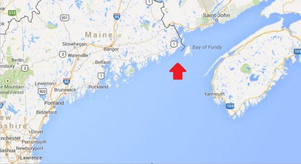
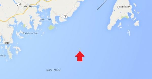
Machias Seal Island is a flat, treeless piece of rock located about 19 kilometres southwest of Grand Manan Island and east of Maine at the mouth of the Bay of Fundy.

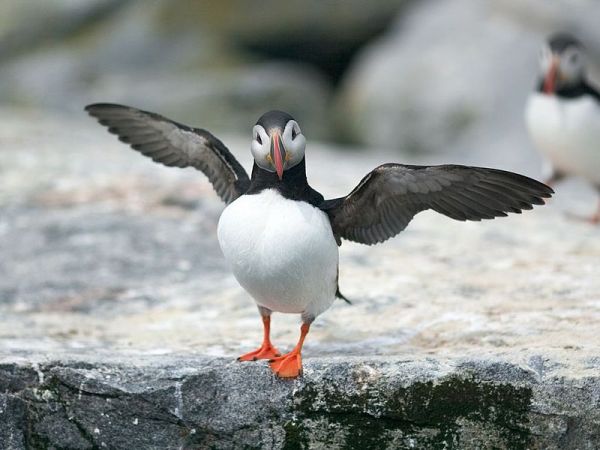
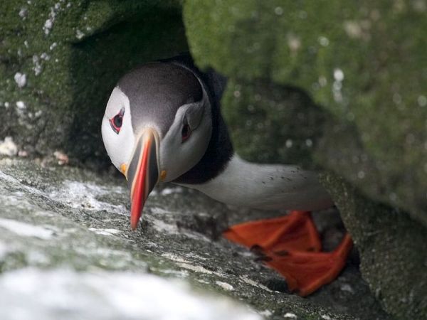
The island is a sanctuary for many kinds of seabirds including the Atlantic Puffin and draws visitors from around the world to observe them in the summer. more . . .

[private]

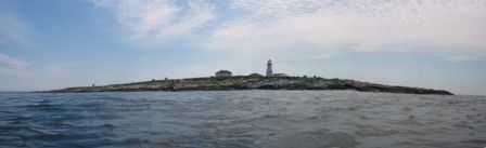
There are no permanent human residents on the island, just pairs of lightkeepers who spend 28 days at a time maintaining a lighthouse operated by the Canadian Coast Guard.

The original lighthouse was built by the British in 1832, and a lighthouse has been maintained there ever since.

So why would anyone even care which country gets title to Machias Seal Island?

‘Wouldn’t we feel silly?’
The answer lies in the 720 square kilometres of water around the island in what’s called a grey zone. Lobster fishermen from both Canada and the U.S. fish these waters.

“The fishing community on Grand Manan is permitted to fish there on an open-end basis and it’s our way of laying our claim to this water that is part of the Machias Seal Island dispute,” said MP John Williamson, who represents the riding of New Brunswick-Southwest.

Williamson said the island is considered to be in his riding.

‘I think our claim is sound and is legitimate.’ —MPJohn Williamson
“I think our claim is sound and is legitimate, but at the end of the day it’s going to come down to the minister in this country and the administration in Washington to settle it,” he said. “I think it is in the interests of both of our countries to do that.”

That feeling is echoed by Stephen Kelly, a professor at the Center for Canadian Studies at Duke University and a retired American diplomat who has served in Canada.

“It just strikes me if we have this opportunity to remove a potential irritant going forward, why don’t we take it?” Kelly said in an interview from his office in Durham, N.C.

Kelly put his thoughts in a commentary for The New York Times last month, which he said he was prompted to write after seeing territorial disputes that have erupted between Japan and China over uninhabited islands in the East China Sea.

He said while the situation between Canada and the United States is much different, land disputes are better settled.

Machias Seal Island

“What if some valuable resource is discovered in the grey zone around Machias Seal Island? What if some other contingency that we can’t imagine now of strategic importance comes along?” he asked.

“Wouldn’t we feel silly that we didn’t take the opportunity to resolve this when the stakes were relatively low.”

 
Irrelevant for lightkeeper

For Ralph Eldridge, a Canadian who has been a lightkeeper on the island for the last 16 years, the question of who owns Machias Seal Island is a “non-issue,” something that is never a question from the visitors who travel to the island each summer.

And Eldridge said he doesn’t have to produce his passport to go there.

“But neither does someone from the United States or China or Japan or Spain have to when they come to the island,” he said.

A spokeswoman for the Department of Foreign Affairs and International Trade said ownership of the island and surrounding waters is clear as far as Canada is concerned: they are Canadian.

“Canada’s sovereignty over Machias Seal Island and sovereign jurisdiction over the 210 square nautical mile surrounding waters is strongly founded in international law,” Barbara Harvey said in a statement.

 [/private]

***********************************

[private]

In the Media
Op-Ed: Canada and US dispute ownership of small rocky island
Digital Journal By Ken Hanly Dec 25, 2012 in World

Tourist comes to Machias Seal Island during the summer to see birds such as the Atlantic Puffin.

Machias Seal Island is a tiny rock island 16 kilometres from the coast of the US state of Maine and 19 kilometers south of Grand Manan Island just off the coast of the Canadian province of New Brunswick. The island is claimed by both Canada and the US.

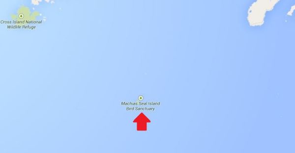
Machias Seal Island has an area of just 8 hectares or about 20 acres. The island is a sanctuary for many seabirds including the Atlantic Puffin seen in the appended video. Visitors from around the world come to view the birds during the summer.
There are no permanent residents of the island although there are lighthouse keepers who come in pairs and stay four weeks at a time. The lighthouse is operated by the Canadian Coast Guard. The original lighthouse was built by the British in 1832. There has been a lighthouse maintained ever since. Many think that the presence of the lighthouse will give Canada a legitimate claim to the island. The United States has never had a presence on the island except in 1918 during the First World War when a small detachment of marines was posted to the island with Canadian agreement.

However in the past private citizens in Maine have claimed ownership of the island. There is a tour boat operator from Cutler Maine, who brings tourists to the island in the summer to view the birds. While there has been no oil or mineral resources discovered in the area, there is a large 720 square kilometres around the island called a grey zone. Lobster fishermen from both Canada and the US fish this area.

MP for New Brunswick Southwest , John Williamson said:
“The fishing community on Grand Manan is permitted to fish there on an open-end basis and it’s our way of laying our claim to this water that is part of the Machias Seal Island dispute.I think our claim is sound and is legitimate, but at the end of the day it’s going to come down to the minister in this country and the administration in Washington to settle it. I think it is in the interests of both of our countries to do that.”

Unfortunately an earlier decision of a joint commission in 1817 did not decide the ownership of Machias Sea Island even though it did decide that of other islands in the area including Moose, Dudley, and Fredericks Islands that are now owned by the US and also Grand Manan island that now belongs to Canada.

Stephen Kelly of Duke University and a retired US diplomat thinks that it would be a good idea to resolve the issue.

“It just strikes me if we have this opportunity to remove a potential irritant going forward, why don’t we take it. What if some valuable resource is discovered in the grey zone around Machias Seal Island? What if some other contingency that we can’t imagine now of strategic importance comes along?Wouldn’t we feel silly that we didn’t take the opportunity to resolve this when the stakes were relatively low.”

Ralph Edlridge, who has been a light-keeper on the island for 16 years, thought ownership was a non-issue. Neither he nor anyone else who comes to visit the island has to worry about showing a passport whether they come from Maine, Canada, China, or Spain he said. Barbara Harvey a spokesperson for Foreign Affairs and International Trade said that as far as Canada is concerned the island is Canadian: “Canada’s sovereignty over Machias Seal Island and sovereign jurisdiction over the 210 square nautical mile surrounding waters is strongly founded in international law.” Some residents of Maine may not agree.

This opinion article was written by an independent writer. The opinions and views expressed herein are those of the author and are not necessarily intended to reflect those of DigitalJournal.com

[/private]

***************************

[private]

December 28, 2012

Private Island News (P.I.N.) ISLAND ISSUES
Canada: The Little-Known Island Dispute Over Machias Seal Island

Image of Machias Seal Island from www.unb.ca

Along the border of the Canadian province of New Brunswick and the American state of Maine sits a small rocky island caught between the two countries.

An almost endless number of headlines have been made in recent months over the (at times heated) conflict between Japan and China over the ownership of a small group of islands in the East China Sea.

Due to the nature of islands, often found along inexact maritime boundaries, ownership disputes are not uncommon – but few of them tend to make headlines. A recent article has shone a spotlight on one of these lesser-known tales, involving a lighthouse isle along the Canada/USA border.

Found at the mouth of the Bay of Fundy, Machias Seal Island is an unassuming rocky outcropping of less than 20 acres, with only a lighthouse tower and outbuildings raised above its flat, barren surface. This modest appearance may be why the island was overlooked during the latter part of the 18th century, when Britain and the newly-formed United States were defining their territorial boundaries. Surprisingly, the intervening centuries have done little to resolve the question of just who owns the island.

While the dispute over Machias Seal Island has remained a friendly one, it has heated up in recent decades. Unlike in the case of Japan and China’s battle over the Diaoyu/Senkaku archipelago, there are no rich offshore oil and gas reserves at stake, however, there is a vibrant lobster fishing industry in the indeterminate “grey zone” of the surrounding waters.

Image of island’s lighthouse from www.ccg.gc.ca

“It’s very congested,” said the head of local fisherman’s association. “It’s a very hard area to fish. The Americans think it’s theirs; the Canadians think it’s theirs, and nobody gets along all that well.”

Canada has, thus far, maintained the upper hand in the conflict – despite an elimination of full-time staff from lighthouses on the East Coast to cut costs, the building on Machias Seal Island bears the distinction of being the sole remaining non-automatic lighthouse in the region, a contiguous occupation that stretches back two centuries.

The Department of Foreign Affairs has been willing to foot the Coast Guard’s bill for the live-in staff, giving only the explanation that it is for “sovereignty purposes”.

Read more about this story: Link [/private]

[private]

Island fever – December 21, 2012

The Chinese are at it. The Japanese are at it. The Brits and the Argentines are at it – all squabbling over small islands. There is even speculation that the US and Canada will revive their long-running dispute over little Machias Seal Island.

When large states are feeling small, it seems, small islands loom large. This is true not just of tiny, uninhabited outcrops. Independent and semi-independent islands are in the limelight too.

One reason for this is clear. Entitled to many of the same rights as large states, but without the same responsibilities, these islands pose an outrageous challenge to the international order and need to be brought back under control.

It is not just their tax practices, although this is the issue that currently defines the EU’s agenda. By selling passports to anyone passing, islands help criminals change identities and travel the globe undetected. And by conferring diplomatic recognition upon renegade countries, islands endanger global security.

There is a second reason too: entitled to many of the same rights as larger states, but without the same responsibilities, small islands are an outrageous challenge to the international order, and are therefore extremely useful allies to big countries.

Thanks to the competition caused by their tax regimes, small islands can be helpful to large countries wishing to impose fiscal discipline upon their partners or just hoping to excuse their own tax practices. And by handing out passports to all-comers, islands can ‘liberate’ the business elites and political opposition of repressive regimes – saving big states the need to intervene.

Small islands are even credited with a diplomatic daring which larger countries cannot afford to practice. Fearful of encouraging secessionist tendencies at home or of antagonising their international partners, large states are often too nervous to recognise breakaway countries. Small islands go where large states fear to tread.

This ambiguous status in an international system made for big players gives islands a significance quite disproportionate to their size. Take for instance Nauru (population: 9,000; size: 21 square kilometres; distinguishing features: looks from above suspiciously like a treasure island).

For years, China and Taiwan were locked in competition for Nauru’s diplomatic loyalty, with Nauru reportedly allowing itself to be bought first by one side then the other. Indeed, in 2002, when the Taiwanese president rocked the world by supporting a referendum on independence, his move was viewed as a reaction to Nauru’s sudden switch of loyalties to the People’s Republic.

The case of Nauru also shows how quickly islands can go from international pariahs to valued partners, depending on large states’ whims. In 2003, the US appears to have decided that the Nauruans’ passport-for-sale scheme was not a danger to international security after all. Just the opposite in fact: it offered a means to smuggle nuclear scientists out of North Korea. If reports are true, Nauru, the one-time bandit, suddenly found itself made deputy sheriff.

This special attitude towards islands – an attitude which does not seem to pertain to other small states – reflects the strong hold they exercise over the popular imagination. Blame that Christmas favourite, Treasure Island. For people living a routine mainland life, islands signify pirates or palm trees: they are either dangerous or alluring.

At one extreme are the harmless bores who view islands as a serious threat to international security and stability, can recite by heart the guidelines on good governance produced with a cheerful lack of irony by the EU, OECD or G20, and show an unhealthy interest in all forms of small-island deviance.

At the other are the escapists who see islands as an alluring alternative to mainland life and who secretly dream of seizing a rocky outcrop and establishing a libertarian utopia of their own.

Islands are thus either ‘unviable’ – incapable of sustaining themselves without cheating on big states, and ripe for depopulation – or an escape – ripe for repopulation by mainlanders. Acknowledging instead that islands are in fact entities in their own right, capable of responsible self-regulation – within the same context of global interdependence that affects all countries – might help avoid unfortunate situations like Nauru’s.

After all, if the reports about 2003’s ‘Operation Weasel’ are accurate, Nauru’s citizens had just succeeded in stopping their government from selling passports on grounds of good governance, only to see the US reintroduce the practice for them.

[/private]

[private]

Machias Seal Island–An Ongoing Border Dispute Between the United States and Canada


(Maps: Google Maps)

This is Machias Seal Island, a 20-acre island in the Bay of Fundy.

You can’t see it? Let’s zoom in.


Hmm. That doesn’t help much. Let’s zoom in some more.


There it is! It’s a speck of land that barely appears on the map.


(Photo: Albnd)

You can see the lighthouse in the photo above. The island is inhabited by 2 human lighthouse keepers, a few seals…


(Photo: Thomas O’Neil)

…and lots and lots of puffins.

The ownership of Machias Seal Island is disputed by the United States and Canada. Canada is in physical possession of it, but the United States has not formally dropped its claim to the island.

I’ve previously written several posts about the development of the US-Canadian border, whichincludes weird exclaves. Ambiguity about the border even led to the creation of 2 short-lived nations.


(Painting by Benjamin West of the American delegation at the Treaty of Paris)

Although the United States and Canada now maintain a long, peaceful border, the placement of that border has been in doubt since the Treaty of Paris (1783) in which Britain recognized the United States as an independent nation. That treaty attempted to draw borders over unexplored lands. The authors did the best that they could with their knowledge of geography. But, alas, one of the descriptions for the border between Maine and maritime Canada was problematic. The treaty says that US territory includes:

all Islands within twenty Leagues of any Part of the Shores of the United States, and lying between Lines to be drawn due East from the Points where the aforesaid Boundaries between Nova Scotia on the one Part and East Florida on the other shall, respectively, touch the Bay of Fundy and the Atlantic Ocean, excepting such Islands as now are or heretofore have been within the limits of the said Province of Nova Scotia.

I’ve bolded the parts of the text that are the source for the Machias Seal Island dispute.

As I’ve mentioned in a previous post, the eastern border of Maine was of great concern to the British. Some British officials coveted what Americans saw as their territory, and vice versa. Control of the Bay of Fundy was of great importance to British commissioners at the Treaty of Ghent (1814), which ended the War of 1812.


(Photo: Thomas O’Neil)

Now back to Machias Seal Island. The American argument is that it lies within 20 leagues (approximately 69 miles) of the coast of the United States.

The Canadian argument is that a land grant that pre-exists the Treaty of Paris defines the island as part of Nova Scotia. It built and has operated a lighthouse on the island since 1832.

Occasionally fishermen from the 2 nations have gotten into scraps about its ownership. Some Canadian citizens have staked mining claims to the island as a means of asserting Canadian sovereignty. The State of Maine has included the island on its maps of electoral districts.

But if possession is indeed 9/10ths of the law, then Machias Seal Island is Canadian. The United States has chosen not to press the issue.

Sources:
Clark, Edie. “Barna Norton Invades Canada.” Yankee 62.6 (1998): 48. Biography Reference Bank (H.W. Wilson). Web. 22 Apr. 2014.

Guo, Rongxing. Territorial Disputes and Resource Management: A Sourcebook. New York: Nova Science Publishers, 2007. Web. Google Books. 22 Apr. 2014.

Kelly, Stephen R. “Good Neighbors, Bad Border.” New York Times, Late Edition (East Coast) ed. Nov 27 2012. ProQuest. Web. 22 Apr. 2014 .

[/private]


Lighthouse History – 51 (1927-02-04 – 1927-06-29)

The following extracts taken from early Victoria, British Columbia (BC) newspapers are credited to Leona Taylor for her excellent work in indexing the papers. Full information can be found here: ”Index of Historical Victoria Newspapers“, 2007-09.

Please Note: December 20, 2012 – I am continuing the series with this Lighthouse History #51 because the newspapers have now been indexed up to 1932. I quit posting at #50 as the extracts only went to 1926. They have now been extended from 1927 to 1932 so I will sift through the data for anything lighhouse! So far, a lot of it appears to be obituaries.

Henry Georgeson, 91, retired keeper of Active Pass lighthouse died Feb 3. [funeral Feb 10, 12…] [Colonist, 1927-02-04, p. 4]


Died May 9, 1927 at V, Captain James Christensen, 86. Resident here in 1864, aged 21, born in Denmark. He worked his way out in a cargo ship from Liverpool. Here he tried shore pursuits until he joined Surprise as mate, and in that capacity in 1869 came in contact with the loss of US bark John Bright, off Hesquiat… [see earlier accounts] 
Christensen was afterwards on schooner Alert, with Captain William Spring, and continued trading on the West Coast for some years. He was a pioneer in the sealing trade. His last journey to the west coast was to take material for the erection of Cape Beale lighthouse in 1876. He was successively in command of Beaver, Pilot, tugs Alexander and Lorne, and in 1891 became pilot for Victoria and Nanaimo districts [8 years]. 
In 1868 he married Mary Linklater, and leaves son, Andrew. His other son, Captain James Christensen, succeeded him as commander of Lorne and afterwards ran other tugs out of Victoria until 1894. In that year he lost his life with all the crew of steamer Estelle, which foundered off Cape Mudge. IOOF. Pallbearers: Captains J E Butler and J Gosse, E More, J Woodriff, W McKay, R Lawson. May 11, 14 – How Captain Christensen Conquered the Doubters… Family plot, H 093b094 E 23. [Colonist, 1927-05-08*] Continue reading Lighthouse History – 51 (1927-02-04 – 1927-06-29)

Columbia III – Another Mission Boat, Another Missionary


On October 14, 2011 I wrote the article Thomas Crosby V – One of the “Bookboats” which described the church mission boat from the United Church of Canada. Now, a good friend Carol Jeffrey found a reference to a new mission boat, the Columbia III which worked for the Columbia Coast Mission from the Anglican Church. Below is a bit of information on this service to isolated posts on the BC coast , including lighthouses.

Western Mariner Magazine December 2006

– text from Jeanette Taylor1

While the headlines of Campbell River newspapers fumed over the millions of public dollars recently allocated for a consolidated mid-Vancouver Island hospital, a small crowd gathered at the city’s Discovery Harbour Pier for a tea celebrating the 50th anniversary of the launch of the hospital ship Columbia III. She was one of the last in a long line of
vessels operated by the Anglican Church’s Columbia Coast Mission. The Mission provided medical, non-sectarian religious and social services to remote settlements, lighthouses, logging camps and First Nations villages along BC’s inside coast from 1905 to the late 1960s.

The launch of Columbia III on October 13, 1956, took place at Star Shipyards (Mercer’s) in New Westminster, just 100 feet from where the second Columbia had been built hy the Dawes Shipyard in 1910. Robert Allan and his son Robert F. (Bob) Allan were in partnership as Vancouver naval architects when Columbia III was designed. Propulsion was a 182-hp Gardner 8L3 (still powering the vessel). Diesel generating and heating units were installed, as well as a propane sterilizer in the hospital cabin, x-ray machine, propane range and refrigerator in the galley and a Spilsbury & Tindall radio-telephone.

The coast has changed radically in the half century since the Columbia III glided down the launch-ways at Star Shipyard (Mercer’s) in New Westminster on October 13, 1956. That year a new hospital was in the offing for Campbell River and there were small hospitals established in Alert Bay and Powell River, but there were still hundreds of people living on the isolated coast between Sechelt and Seymour Inlet with little or no access to medical care or regular social contacts. No matter what the religious convictions of these people, the arrival of the Columbia was a welcome sight.

Sea Kayaking Tours in BC Canada

The Columbia Coast Mission saved hundreds of lives when its vessels hastened to logging camp accidents. The mission also provided a cherished social outlet. “It was very exciting when the Columbia came because there was very little entertainment for us,” remarked one of the attendees at the 50th anniversary tea held onboard Columbia III. In
those days the Columbia’s staff brought books, showed movies and hosted Christmas pageants, complete with a portly Santa Claus. Mothership Adventures, which offers eco and cultural tours in inside waters with the Columbia III, has had new owners since 2005, Ross Campbell and Fern Kornelsen of Sonora Island, and they welcomed the idea of the 50th celebration. The vessel’s aft double doors, designed originally to provide access for stretchers, were opened wide to a crowd which filled the saloon and aft deck to reminisce about the Columbia Coast Mission. The Campbell River stop came at the end of a 50th
anniversary voyage which originated in Port McNeill and threaded its way south with an enthusiastic group on board, all the members of which had past associations with the coastal ‘mission ships’. Along the way they revisited many homesteads, settlements and villages which had been regular stops during the Columbia’s service.Well aware of the Mission’s historic service Campbell and Kornelsen were pleased to return Columbia III to this part of the coast. But they weren’t prepared for the depth of feeling many still hold for the Mission and its ships. Wherever they tie up people have memories to share. On the recent anniversary cruise a young man asked the Columbia’s skipper to give a blast on the ship’s distinctive whistle as they passed the Alert Bay home of his 90-year-old grandmother, “for old time’s sake.” At the Whaletown wharf on Cortes Island, once frequented by the Coast Mission vessels, a small crowd gathered to watch Columbia III pull alongside. “I got a call from a neighbour,” said Jan Boas. “She said, ‘The Columbia is coming!’

This summoning call was heard frequently on this coast in days gone by. Prior to the advent of the Columbia Coast Mission in 1905 there were more than 100 isolated logging camps and settlements scattered along the coast and accidents were alarmingly common. The only hope, in the case of serious injury, was to row out into one of the main passages in an often futile search for a passing freight or passenger steamer. A lucky few
survived under these circumstances. The arrival of four dead loggers in Vancouver on a steamer galvanized the Mission’s founder, Reverend John Antle, into action. He persuaded his church to launch the first Columbia and later raised funds for four hospitals throughout the region.

By the time the Columbia III was launched in 1956, the coast was undergoing rapid change. Timber licences were being awarded almost exclusively to large companies, cutting out the smaller operators. This, and greater utilization of float planes over sea-going vessels and the establishment of highways and ferry connections between coastal centres, began to depopulate the coast. By the early 1960s only a hardy few still lived in isolation. Even the chaplains from the Mission took to the air in a Cessna floatplane, a practice which continued through the 1970s.

A gathering on the foredeck of the Columbia III, Kingcome Inlet in the 1960s. Judging by the
finery and the babe in mother’s arms and the Columbia Coast Mission chaplain to right in photo, this was probably a christening ceremony

The last sea-going chaplain with the Columbia Coast Mission, Rev Ivan Putter, arrived in 1965. He had a Decca radar installed so, while the Columbia III was by then serving as mobile aviation fuel rendezvous and a base of operation for the plane which could branch out to isolated pockets of the coast, the vessel continued to help the sick and injured and save lives when the plane was fogbound. However in 1967 the Columbia III was put up for sale. By 1982 the Mission had ceased operation.

Columbia III then passed into the hands of a string of owners and was a liveaboard in False Creek in Vancouver and in a pretty run-down condition when acquired by Bill McKechnie of Victoria in 1990. He worked with shipwright Paul Heron and several Victoria craftspeople on a well-thought-out and classy refurbishment. Original areas such as the doctor’s office and galley were reconfigured and, below decks, the chapel, chaplain’s stateroom and infirmary were converted to cabins and accommodation for 10 berthed passengers and crew members. McKechnie also started Mothership Adventures, a successful ecotourism venture which enabled Columbia Ill’s guests to explore wilderness areas of the mainland around the Broughton Archipelago and the Central Coast through a combination of cruising and kayaking.

A group of people, all with an association with the mission ships, revisited some of the old
haunts between Port McNeill and Campbell River in early October, 2006. Here they are
seated in Columbia Ill’s main saloon, the former hospital cabin. The large bright windows
and mahogany cabinetry and furnishings were part of the extensive 1990s refurbishment
overseen by owner Bill McKechnie in Victoria.

The inset photos show the wheelhouse and the engine room with the 8L3 Gardner that was in Columbia when launched 50 years ago.

Mothership Adventures and Columbia III were sold in the early 2000s to a Seattle owner who intended continuing the business in BC waters. However, he couldn’t make his way around the Canadian 60-ton master’s ticket requirement for Columbia III. Meanwhile Ross Campbell and Fern Kornelsen, who had fallen short in their attempts to buy Mothership Adventures from Bill McKechnie, continued to make it abundantly clear to the US owner that, if he wanted to sell, they would buy. They became owners in early 2005.

The Columbia III in her role as a ‘sea kayaking mothership’.

“The Columbia is always welcome wherever we pull in,” says Ross Campbell. “We feel we are custodians of a significant vessel in BC’s maritime heritage and we try to live up to her good name.”

In that spirit Campbell and his family have agreed to make the ship available for weddings and memorial services for the many people who hold the Columbia’s memory dear. And, Ross adds, “We’ll be working to give her another 50 years on the coast.”

************************************

Here is a story from The Evening Citizen, Ottawa, Friday November 27, 1953

Vancouver (CP)-A missionary of the sea plays a vital part in the lives of 4,000 persons along the lower British Columbia coast.

From inlet to inlet, the mission ship Columbia II skippered by Capt. George A. MacDonald, a friendly 70-year-old Vancouver man, brings spiritual and physical comfort to loggers, fishermen and settlers in some 225 isolated communities.

The sturdy 100-foot diesel-driven ship plies from Stuart Island and Cape Scott at the northern tip of Vancouver island.

Veteran Chaplain

The chaplain is Canon Heber Greene, a veteran missionary, and the ship’s medical facilities are directed by Dr. J. G. Kempff.

In the tiny chapel, there have been weddings, christenings, confirmations, and funeral services.

“We handle hatches, matches and dispatches,” says a crew member.

The ship is one of four operated by the Columbia Coast mission of the Church of England in Canada.

Many mercy missions are undertaken by the 48-year-old Columbia. Last year she logged 31 emergency calls for sickness and accident cases.

“Calling the Columbia” is a frequent call over the ship’s radio-telephone, coming from the coastal districts dotting the rocky island shoreline.

One Mishap

She takes nine six-week cruises a year, and only once has she suffered a mishap. In 1948 she piled onto a reef in Warner Bay and was laid up some six weeks for repairs.

Capt. MacDonald has been with the Columbia for 17 years. With him he has engineer Bob McCree, Jack Owens as cook, and Bob Anderson, deckhand.

Off the main deck is a two-bed hospital equipped with examination table, dental chair, drugs and surgical instruments. Only minor operations are performed. Serious cases are taken to hospital at Alert Bay, the Columbia’s home port, 225 miles northwest of Vancouver.

There are recreational comforts too. There is a reading room, much used by lonely settlers, and a movie theater, where various films are shown during visits to upcoast ports.

“We feel we cover the whole life of the people,” said Canon Alan Greene, superintendent of the mission and brother of the Columbia’s chaplain.

Better Than Planes

Talk of the mission ship being replaced by an airplane gets little sympathy from mission authorities.

Storms and fogs have been battled by the Columbia on mercy missions. Under similar bad weather, a plane would be grounded.

“The plane lacks the personal touch,” added Canon Alan Greene, and his views are shared by Captain MacDonald.

The first mission boat was launched by Rev. John Antle in 1905 when Columbia Coast Mission was founded. It voyaged for man years along the coast, was replaced by the Columbia II. The old and expensive Columbia II, too, may be replaced, this time by a smaller vessel.

Of the 13,259 miles covered by the Columbia in 1952, 1, 295 miles were logged on emergency calls. She made a total of 1,047 calls, during which 807 cases were treated. Her sister ship, the John Antle, the Rendezvous, and the Veracity, travelled 6,000 and 5,383 miles, respectively. Three vessels are confined to mission work only.

Such coverage entails an annual expenditure of $75,000, most of which is incurred by the Columbia. The Community Chest of greater Vancouver bears the major part of the ship’s operating expenses, with the provincial and federal governments contributing small grants. The balance is provided through church contributions and private donations.

****************************

FOOTNOTE:

1 Jeanette Taylor is a Quadra Island-based writer and interpreter of BC coastal history and heritage. She has worked with the BC Archives aural history division and held curatorial and programming positions with the Campbell River Museum. She is the author of River City: A History of Campbell River and the Discovery Islands (1999, Harbour) and Exploring Quadra Island: Heritage Sites
and Hiking Trails (2001, Harbour) and is writing a history of the Discovery Islands and adjacent inlets.

Re-inventing the Wheel, er, The Paddleboard


This not a lighthouse story, but it shows what interests a lighthouse keeper. If you live near the sea, you are always interested in ways and means of travelling, fishing , and exploring on the ocean. It is only natural. Here is my newest find – a SUP!

****************************

After posting the story “Stand” – An Adventure Documentary on November 14, 2012, I was really intrigued by the surfboards the people were using in the film.  They were not really surfboards as they appeared to be too heavy even though made of native British Columbia (BC) cedar wood.

A Cedar Strip Stand Up Paddleboard (SUP)

As you can see from the photo above, they are called a Stand Up Paddleboard (SUP). I had never heard of them before, and thought they would be ideal for adventurers on the BC coast, or anywhere! Continue reading Re-inventing the Wheel, er, The Paddleboard

Reprint – Restoring Canaveral Light – Brick by Brick!


Restoring Canaveral Light – Brick by Brick!


The mission statement of the Cape Canaveral Lighthouse Foundation is  “To Assist the 45th Space Wing in preserving, protecting, and interpreting the Cape Canaveral Lighthouse and its historical significance to the Florida Space Coast, State of Florida, and our Nation.” The US Air Force owns and maintains Cape Canaveral Light, but the Foundation exists to be of assistance in its restoration and to share its remarkable history.

In many ways Cape Canaveral and the Lighthouse is a bridge between the age of exploration and exploration yet to come; a bridge between the sea and the stars!

On October 13th, 2012 I attended a gathering at the Canaveral Lighthouse with my father to celebrate the progress having been made on the restoration of this special and significant beacon. Although, we had visited the light by special permission a couple of years ago in order to photograph, I did not then have the opportunity to see the interior of the tower. Saturday, October 13th, could not have been a more perfect day to gather, discuss goals, walk the newly built Keeper’s Brick Paver Walkway, and climb!! I have to say right here that I was amazed that my 88 year old father was able to navigate the stairs better than I did!  The metal lighthouse is lined with brick and the winding stairs curl upwards around a center pole with no hand railing along the brick walls. Of course, it was probably because I was lugging my heavy camera!! Probably!! Continue reading Reprint – Restoring Canaveral Light – Brick by Brick!

Reprint – Cape Canaveral Light – Warden of the Sea, Launchpad to the Stars!


The following story is the first of two parts on the Cape Canaveral lighthouse by Judy Lovell, a photographer extraordinaire, who runs a WordPress blog called Janthina Images.

Besides this article, and the one following, please view her image gallery on her website as well. In the gallery she has some lovely photos of Florida lighthouses with prints available for sale. Enjoy, and drop by her website occasionally for different articles. If you wish to view the image gallery as a slideshow, please click here.

***********************************

Cape Canaveral Light – Warden of the Sea, Launchpad to the Stars!

They fill that night with Knowledge. A thousand ships go by,
A thousand captains bless them, so bright and proud and high:
The world’s dark capes they glamour; or low on sand banks dread,
They, crouching, mark a pathway between the Quick and Dead —
Like star points in the ether
They bring the seamen ease,
These Lords of Wind and Weather
These Wardens of the Seas!

…Edwin James Brady…

Lighthouses have long stood at the edges of the world, lonely outposts maintained by devoted souls to ensure the safety of ships at sea. But, only one remarkable beacon was destined to illuminate the path for ships of space! But how did this happen? How did a lighthouse built on a hook of sand jutting out into the Atlantic to protect mariners from dangerous currents become a front row witness to the advent of the Space Age?

Rocket Launch with Canaveral Lighthouse is courtesy NASA Continue reading Reprint – Cape Canaveral Light – Warden of the Sea, Launchpad to the Stars!

I Could Not Have Said It Better!

UN-CRUISE Blog

Five Finger Lighthouse

October 23, 2012 at 11:48 AM by Alyson

By Alison, Expedition Guide, Wilderness Discoverer

 Throughout the season, our boat passed the Five Finger Lighthouse in Frederick Sound. The story about the great fire of 1933 and the lighthouse refit was shared by guides, but upon reflection, we never covered what this lighthouse symbolized for those that used the structure.


Five Finger Lighthouse in Frederick Sound

This particular lighthouse was a home to the keepers, a guiding light for passing boats, a place to find companionship whilst reuniting with friends or visiting neighbors, and a trading post to deliver and purchase supplies, and now is a whale research station. The only dwelling that stayed constant for those on the seas, living on fox farms, or prospecting for gold was the familiar beacons on treacherous cliffs, which could be why, when we think of lighthouses, the first word that comes to mind is hope.

As the Wilderness Discoverer traveled down the waterways of SE Alaska, British Columbia, and the islands of the Pacific Northwest, the sighting of lighthouses spurred heartfelt conversations. The structure, the light, sea stories and shipwrecks, and those histories similar to Five Finger Lighthouse may have conjured up emotions of moving toward home. Observing lighthouses along the shore gives a feeling of solace and may have acted as a symbol of hope for warmth, love, safety, security, direction, and a lifeline to the outside world.

Read more about the Five Finger Lighthouse: 5fingerlighthouse.com

West Coast Recipes – Part One


I thought this might be interesting for people in other parts of the world who read this website. There are many food recipes associated with the West Coast of Canada and USA – many from the First Nations people, and many from the residents be they mariners, lighthouse keepers, villagers, prospectors, hunters or others. I will try and see what I can find. I will try and post about five (5) recipes per post. If others have any contributions, please pass them on. Full credit will be given.


One recipe I have posted can be found here: Thomas Crosby Muffins. Also a book was written about British Columbia lighthouses called The Lighthouse Cookbook by Anita Stewart. It is an excellent book and is available from Amazon.com.


******************************** 

1. Salmon Fish Cakes

Now this is one of the simplest recipes to make, and I learned about making them from my wife Karen who’s father used to cook them while out on the West Coast fishing for salmon. His recipe was pretty simple: Use whatever is available! Take some leftover cooked salmon, mix it about half and half with some leftover cooked potatoes, throw in an egg to help hold it together and season with salt and pepper. If available, add a few chopped green onions. Make into patties and fry in one-quarter inch (1/4″) oil, flipping once until brown on both sides. Serve with whatever condiment is available – lemons and/or ketchup.  Enjoy!

Below is a more cookbook style of making the same thing:

Salmon Fish Cakes

1 1/4 lbs potatoes, peeled and cut into chunks

1 lb salmon fillets, skin on, scaled and bones removed (or in a pinch try using 2 cans of Clover Leaf’s canned boneless/skinless salmon) Continue reading West Coast Recipes – Part One

Lightkeeper Retirement Homes

No, this does not refer to retirement homes such as you are imagining for senior citizens. This is a fictitious tale of what I imagine a lightkeeper might look for in a home when he retires. None of these homes are actually inhabited by a lighthouse keeper, as far as I know, but they appealed to me as a place where a keeper might like to retire.

Most keepers hate to leave their lighthouse homes at all, but sometimes, as in my case, retirement beckons too strongly and we give up the solitary life. Maybe we would move into . . . 

1. How about this one?

I saw this little dwelling and its location and immediately fell in love with it. It is isolated; it is near water; it even has a boat (note the kayak beneath the house). I still ride a bicycle, so why not paddling a kayak into old age? Perfect location for me.

The photograph is by Irene Becker for National Geographic Picture of the Day: A Tiny River House in Serbia. The website says:

A house in the middle of the Drina River near the town of Bajina Basta, Serbia. The Drina is a 346 km long river that forms much of the border between Bosnia and Herzegovina and Serbia. It is the longest tributary of the Sava River and the longest karst river in the Dinaric Alps.

i searched via Google Earth and finally found the location at latitude 43°59’3.73″N, Longitude 19°33’59.67″E (Google Earth KML file with several more photos of the house). Continue reading Lightkeeper Retirement Homes

Chris Mills – Canadian Lighthouse Photographs


Canadian Lighthouse Photographs

New website is coming.
http://www3.ns.sympatico.ca/ketm/
is no longer online


Chris Mills
1121 Ketch Harbour Rd.
Ketch Harbour, Nova Scotia  B3V 1K7


British Columbia | Nova Scotia | Prince Edward Island | New Brunswick | Newfoundland

Chris Mills served as a lighthouse keeper for the Canadian Coast Guard on both the Atlantic and Pacific coasts.

He is currently co-chair of a committee which is recruiting Members of Parliament in support of a private members bill to protect lighthouses.  To see how you can help, visit this site:  Canada Needs a Lighthouse Protection Act.

Photographs and enlargements are for sale. Contact Chris Mills for price information.
All photographs and slides in the collection are identified, dated and signed.

Chris Mills is also author of the book on Nova Scotia lighthouses Lighthouse Legacies available from Amazon.ca


Sambro Island restoration project


BRITISH COLUMBIA

Some of these photos may be viewed at the Lighthouses of British Columbia site.

Green Island (1994, 1995) 250 colour photos, 70 colour slides in collection. All aspects of the station and island documented — aerial views, sea views, night views, details of light and lighthouse, lightkeepers, Coast Guard helicopters, surrounding islands and seascapes.


Langara Island (1994, 1996) 250 colour and 25 black and white photos, 180 colour slides in collection. All aspects of station documented — aerial views, night views, detailed views of 1913 First Order Fresnel Lens (manufactured by Chance Brothers), light tower and lantern, lightkeepers, dwellings, interior of engine room, old cabin on island, face carved in tree, shoreline views, lightkeeper’s goats, stormy seas.


Triple Island (1994) 24 colour photos in collection. Aerial views, third order Fresnel lens, lightkeeper, detailed views of lighthouse structure, interior of workshop and engine room.


Bonilla Island (1994) 250 colour photos in collection. Many aspects of station — aerial views, sea views, night views, shoreline views (including Japanese glass fishing floats), lightkeepers, dwellings, engine room interior, light tower. (NOTE: this collection will be expanded during Sept/Oct 1996)


Boat Bluff (1994-1996) 160 colour photos in collection. All aspects of station — aerial views, sea views, night views, details of light tower, fog horns , engine room, main light (including views of keeper inspecting light at night, inspection of light and bulbs during day), views of station and mountains from 1000 foot hill across the channel from lightstation, snow views, old hand fog horn, three modern plastic lenses, sunrise views, surrounding bays and inlets, Santa and Mrs. Claus visit 1994. (NOTE: Available as of Dec. 1996 — selection of a further 200 colour and b&w prints taken during August 1996, including Coast Guard ship and work crews supplying station.)


Ivory Island (1994-1996) 600+ colour and 36 black and white photos, 100 colour slides in collection. All aspects of the lightstation — 30 aerial views, sea views, night views, lighthouse, keepers, dwellings inside and out, engine room, main light, surrounding area, beaches, salmon fishing, snow, totem poles, artist and photographer at work at the lightstation, Coast Guard helicopters, sunsets, shoreline and forest, various tidal life (sea stars, crabs, etc.), local minor beacon lights, 25th annual Santa and Mrs. Claus visit December 1995.


McInnes Island (1994, 1995) 48 colour photos, 22 colour slides in collection. Aerial views, lighthouse structure, radio room, keeper, detail of lantern and main light, large thunder cloud formations.


Dryad Point (1995) 32 colour photos in collection. Aerial views, light tower, main light, keeper and daughter, keeper and main light, dwelling. (NOTE: This collection will be expanded during 1997)


Addenbroke Island (1994) 14 colour photos in collection. Aerial views.


Egg Island (1994) 10 colour photos in collection. Aerial views.


Pine Island (1994) 3 colour photos in collection. Aerial views.


Scarlett Point (1994) 2 colour photos. Aerial views.


Point Atkinson (1994) 14 black and white photos in collection. Light tower, keeper and main light, station dwellings and exterior of radio/engine room.


Brockton Point (1994) 5 black and white photos in collection. Light tower.


Porlier Pass (1994) 32 colour photos in collection. Two light towers (Porlier is a range light station), main lights, boat and boathouse, lightkeeper, dwelling, interior engine room and fog horn building, Coast Guard hovercraft. (NOTE: The old front range light was demolished Feb. 1996 and replaced by a fibreglass tower and the lighthouse was automated shortly after.)


Fisgard (1994) 6 colour, 2 black and white photos in collection. Light tower and detail of gothic style window in old keepers dwelling.


Sheringham Point (1994, 1995) 20 colour photos in collection. Light tower, abandoned dwelling, sunset, old Fresnel lens at local museum.


Amphitrite Point (1995) 9 colour slides in collection (prints available). Lighthouse structure, old keepers dwelling.


Lennard Island (1995) 52 colour photos, 25 colour slides in collection. Traveling to island by boat, keeper in boat, keeper in lighthouse, keeper and wife on station grounds, dwellings, radio room, engine room, details of two fog horn systems, including traditional diaphone horn taken out of service Oct. 1995, light tower, station grounds.


Cape Scott (1996) 23 colour photos in collection. Aerial views.

NOVA SCOTIA

Some of these photos may be viewed at the Nova Scotia Lighthouse Preservation Society site.

Baccaro Point
Bear River
Beaver Island
Black Rock Point
 (new lighthouse)

Black Rock Point (old lighthouse)
Boar’s Head
Brier Island
Cape Forchu
Cape George
Cape Sable
Chebucto Head
Fort Point
 (LaHave River)

Fort Point (Liverpool)
Fourchu Head
Gabarus
George’s Island
Grand Passage
Hampton
 (Chute Cove)

Horton Bluff
Jerome Pont
Louisbourg
Low Point
Maugher’s Beach
Medway Head
Peggy’s Cove
Point Aconi
Port Greville
 (old light, now at Canadian Coast Guard College, Point Edward, N.S.)

Port Medway
Prim Point
Rouse Point
Sable Island
 (east light)

Sable Island (west light)
Sambro Island
Scatarie Island
Schafner Point
Seal Island
Sydney Range
 (front light)

Sydney Range (rear light)
Western Head
Battery Point
Betty’s Island
Canso Locks
Cross Island
 (comprehensive collection including automation day)

Eddy Point
Mosher’s Island
Seal Island
 (comprehensive collection)

Seal Island Lighthouse Museum

PRINCE EDWARD ISLAND

Blockhouse Point
Borden Range
 (front light)

Borden Range (rear light)
Cape Bear
Cape Tryon
Brighton Beach Range
 (front light)

Brighton Beach Range (rear light)
East Point
Murray Harbour Range
 (front light)

New London Range (rear light)
North Rustico
Panmure Island
Point Prim
Souris East
Summerside Range
 (front light)

Summerside Range (rear light)
Woods Islands
Woods Islands Range
 (front light)

Woods Islands Range (rear light)

NEW BRUNSWICK

Cape Spencer
Cape Tormentine
Fish Fluke Point
 (Grand Harbour)

Gannet Rock (comprehensive collection: 700+ prints and slides)
Great Duck Island
East Quoddy
 (Head Harbour)

Letite
Long Eddy
Long Point
Machias Seal Island
 (comprehensive collection)

Mulholland Point
Southwest Head
Swallowtail

NEWFOUNDLAND

Cape Anguille
Cape Ray
Cape Saint Francis
 (dwelling only)

Cape Saint Mary’s
Cape Spear
Lobster Cove Head
Rose Blanche
 (old stone lighthouse)