The world’s oldest lighthouse (the Pharos of Alexandria) was built by Sostratus of Cnidus around 270 BC.
The oldest UK lighthouse? The lighthouse and lightkeeper’s house at Spurn.
It was a pyramid-shaped tower of white marble on the island of Pharos (in Greek the word Pharos means lighthouse) off the coast of Alexandria, Egypt.
It was estimated to be 400ft tall, and was one of the Seven Wonders of the World, a listing designated by Antipater of Sidon in the second century BC.
This formed part of Alexander’s Harbour, Alexander being of course Alexander the Great.
Alas, the lighthouse was destroyed by an earthquake in 1375 AD.
Unfortunately, the Guinness Book Of Records never provided a listing for the oldest British lighthouse. – read more
*****************************
The oldest lighthouse in my home country ofCanada was built in 1713 and went into service at the French fortress of Louisbourg on Cape Breton Island in 1734.
What is the name and location of the oldest lighthouse in your country? Write me a note and let me know and I will post it here.
[private]
THE world’s oldest lighthouse was built by Sostratus of Cnidus around 270 BC, writes Tim Mickleburgh.
It was a pyramid-shaped tower of white marble on the island of Pharos (in Greek the word Pharos means lighthouse) off the coast of Alexandria, Egypt.
It was estimated to be 400ft tall, and was one of the Seven Wonders of the World, a listing designated by Antipater of Sidon in the second century BC.
This formed part of Alexander’s Harbour, Alexander being of course Alexander the Great.
Alas, the lighthouse was destroyed by an earthquake in 1375 AD.
Unfortunately, the Guinness Book Of Records never provided a listing for the oldest British lighthouse.
So when this came up as a quiz question recently, I was stumped, expressing ignorance when the answer was given as Spurn Head.
This though set me to do some private research.
Fortunately I have the book written by Kenneth E Hartley and Howard M Frost, The Spurn Head Railway (Second Edition 1988). It gives reference to a hermit named Reedbarrow being responsible for erecting a lighthouse in c1427, going on to state that “following the unrecorded disappearance of Reedbarrow’s early lighthouse a London man, Justinian Angel, erected a lighthouse at Spurn during the years 1673-4”. There is no claim however that the lighthouse was Britain’s first.
So I then turned to Lynn F Pearson’s Piers And Other Seaside Architecture (Second Edition 2011) for enlightenment. But it wasn’t to be, as lighthouses don’t feature within its pages.
The AA Book Of The Seaside (1972) is of more help, telling readers that only 11 lighthouses existed by the 17th century, all on the south coast. It adds that the Roman Pharos in Dover castle was “one of the earliest surviving examples … from this dim brazier … lighthouses have slowly developed”.
This though presumably wasn’t a standalone building, unlike that at Spurn Head.
Thus I await further information from amongst your erudite readership!
Do you know which is Britain’s oldest lighthouse? If you can help, then please write to Bygones, Grimsby Telegraph, 80 Cleethorpe Road, Grimsby, North East Lincolnshire DN31 3EH or you can e-mail bygones@grimsbytelegraph.co.uk
A lot of people who visit Victoria, British Columbia (on the southern tip of Vancouver Island) never get to see Trial Island lighthouse as it is not visible from the town core. One must travel to the Oak Bay waterfront to see the lighthouse.
Although it is only about half a mile from Oak Bay, most people see only the radio station antennas of BC TV on a black rock be it day or night.
An interesting article on the web is Trial Island Lighthouse & VE7DQA – describing the life of a Ham Radio operator living and working there.
Trial Island is NOT an isolated station compared to West Coast Vancouver Island lightstations like Carmanah Point, Pachena Point and Cape Beale, but it is an interesting place to work.
Google Interactive Map showing the location of Trial Island.
I have mentioned Machias Seal Island before in my articles here, here, here, and here.
Well writer John Farrier published on Neatorama on Tuesday, April 22, 2014 a great article about how MAJOR/insignificant this dispute really is!
(Maps: Google Maps)
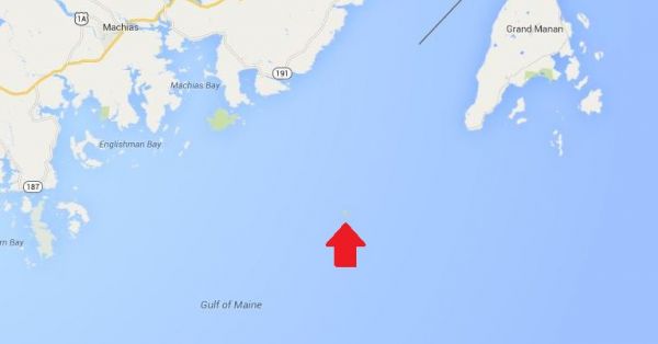
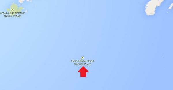
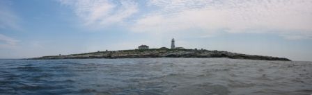
This is Machias Seal Island, a 20-acre island in the Bay of Fundy.
You can’t see it? Let’s zoom in.
And from there the story continues! Such an insignificant island for such a big debate. That is government for you. Naturally it belongs to Canada! . . . more
[private]
Hmm. That doesn’t help much. Let’s zoom in some more.
There it is! It’s a speck of land that barely appears on the map.
The ownership of Machias Seal Island is disputed by the United States and Canada. Canada is in physical possession of it, but the United States has not formally dropped its claim to the island.
I’ve previously written several posts about the development of the US-Canadian border, whichincludesweirdexclaves. Ambiguity about the border even led to the creation of 2 short-lived nations.
(Painting by Benjamin West of the American delegation at the Treaty of Paris)
Although the United States and Canada now maintain a long, peaceful border, the placement of that border has been in doubt since the Treaty of Paris (1783) in which Britain recognized the United States as an independent nation. That treaty attempted to draw borders over unexplored lands. The authors did the best that they could with their knowledge of geography. But, alas, one of the descriptions for the border between Maine and maritime Canada was problematic. The treaty says that US territory includes:
all Islands within twenty Leagues of any Part of the Shores of the United States, and lying between Lines to be drawn due East from the Points where the aforesaid Boundaries between Nova Scotia on the one Part and East Florida on the other shall, respectively, touch the Bay of Fundy and the Atlantic Ocean, excepting such Islands as now are or heretofore have been within the limits of the said Province of Nova Scotia.
I’ve bolded the parts of the text that are the source for the Machias Seal Island dispute.
As I’ve mentioned in a previous post, the eastern border of Maine was of great concern to the British. Some British officials coveted what Americans saw as their territory, and vice versa. Control of the Bay of Fundy was of great importance to British commissioners at the Treaty of Ghent (1814), which ended the War of 1812.
Now back to Machias Seal Island. The American argument is that it lies within 20 leagues (approximately 69 miles) of the coast of the United States.
The Canadian argument is that a land grant that pre-exists the Treaty of Paris defines the island as part of Nova Scotia. It built and has operated a lighthouse on the island since 1832.
Occasionally fishermen from the 2 nations have gotten into scraps about its ownership. Some Canadian citizens have staked mining claims to the island as a means of asserting Canadian sovereignty. The State of Maine has included the island on its maps of electoral districts.
But if possession is indeed 9/10ths of the law, then Machias Seal Island is Canadian. The United States has chosen not to press the issue.
La saison démarre bien, j’ai déjà accueillit beaucoup de monde. Et qui dit nouvelle saison , dit “Nuit du Phare”. La première nuit de cette année aura lieu lundi 5 mai à partir de 21h30. Toutes les 1/2h. un groupe de 20 personnes pourra venir admirer la mer d’Iroise et ses phares à partir du chemin de ronde. Visite uniquement sur réservation au 0298890017 ou 0686310347.
Fishing boats do not have anything to do with lighthouses you say!
Well they do, because without fishing boats (plus vessels of other types) and the men that man them we would have no need for manned lighthouses, so fishing boats are important for lighthouses and the British Columbia (BC) economy.
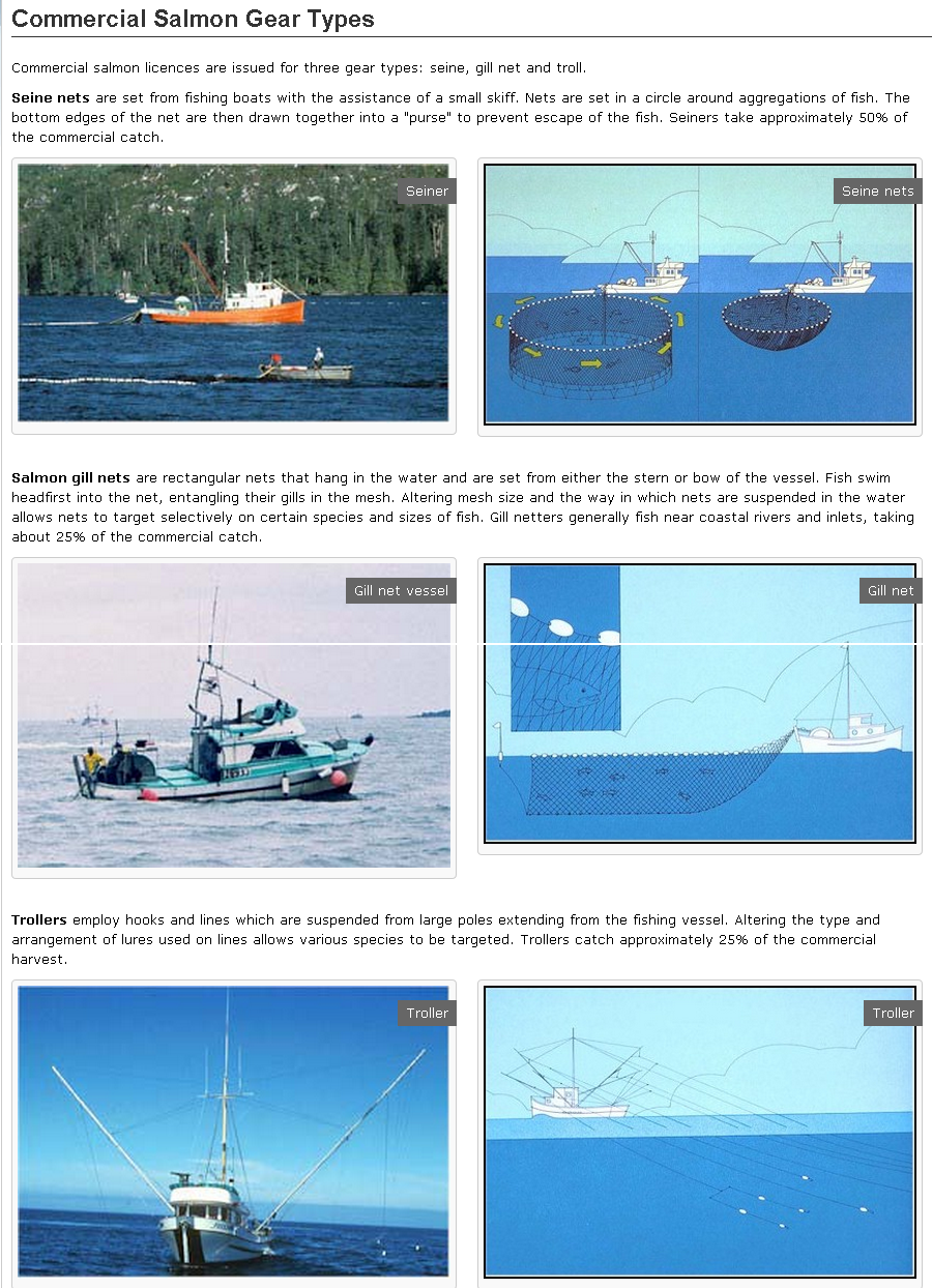
Trolling, Seining, Gillnetting – don’t know one fishboat or fishing method from the next? Well take a look at this page from Fisheries and Oceans Canada. It will help clarify things.
On September 21, 2013 I wrote Message in a Bottle which described a 107 year old message-in-a-bottle find. Later on October 29, 2013 I wrote More Messges in Bottles which described more messages found in bottles. It seems that everybody loves to do it!
German fishermen made a surprising catch this week when they pulled the oldest recorded message in a bottle out of the sea. A man from Berlin scribbled the note 101 years ago. . . . more
[nggallery id=94]
[private]
What initially looked like a normal, discarded beer bottle, nestled among fish in the Maria I’s nets, turned out to be a record-breaking find – as it contained a postcard dated May 17th, 1913 written by a man named Richard Platz.
A modest Danish postcard with two German stamps on it and a polite message asking the finder to send it on to his address in Berlin; it appears that Platz could have been trying to save on international postage fees.
But the card never arrived, instead landing in the hands of fishermen from Heikendorf in Schleswig Holstein, on Tuesday – over 100 years later.
“I had it in my hand, but then a colleague told me there was something in it,” skipper Konrad Fischer told regional newspaper the Kieler Nachrichten, explaining he was ready to throw it back into the Baltic.
“When I saw the date I got really excited,” he said.
Until now, the oldest message in a bottle listed in the Guinness Book of Records was 97 years old when found in 2012, making Fischer’s a potential record breaker.
“If the message is really this old, maybe a museum would be interested,” said Fischer, who will be taking his bottled post to experts for them to take a closer look.
Fischer has been a fisherman for 50 years and in that time has found mines, bombs, torpedoes and a corpse in the sea.
He told news agency DPA that he was not sure yet what he would do with the bottle but would “maybe auction it to the highest bidder”. [/private] Continue reading It’s Old, But Not The Oldest!→
For an update on what a Mise Tale is then please see Mise Tales One. As mentioned earlier on the front page of my website, any photos or cartoons, or short bits of information, when it is removed from the front page, will also be included again later in the next Misc Tales. That way you can keep track of it, search for it, or copy it.
*****************************
survival necklace s1401 from Cougar Fashion in Tahsis, British Columbia
from the rainforest, for the rainforestprice $12.50this necklace is transformed to emergency fishing gear within minutes. all you need is a pocket knife.
contents: – 3.8 m. fishing line – 3.5 cm. bait hook – interlock snap swivel – split ring – 6 cm. hoochie
Now this is a unique West Coast piece. It is a very beautiful necklace and would draw comments wherever it is worn. I am not too sure how practical it would be with only 3.8 meters (12.5 feet) of fishing line, but anything could work in an emergency.One would be better off also wearing a Survival Strap (get one in a matching colour) to add length to the necklace. Hey, two unique pieces of survival jewelry which you can wear anytime. Check out all the other items which you can find at Cougar Fashion. Continue reading Mise Tales Forty→
What light is that? Have you ever asked yourself that question? Maybe when reading a magazine, seeing an advertisement, or watching a movie – what lighthouse is that? Where is that lighthouse?
computer screenshot
Well this happened to me while I was watching the first of the Jason Bourne movies – The Bourne Identity (IMDb)
Eight (8) minutes into the DVD movie (see screen shot at right) the fishboat that rescued him from the ocean enters Cassis harbour (according to the book by Robert Ludlum) and we see this green light at the end of a breakwater. Unfortunately the movie does not follow the book at all (“The novel is wildly
Cassis harbour light look likes this
wildly different from the movie.”) and I have no idea where this harbour is located. It is definitely not Cassis harbour near Marseille, France. If you look at the film you will see as they enter the harbour there is a shipyard on the left side – there is definitely no shipyard in the photo on the right. Of the fifteen places listed in the IMDb website for the film locations, none of them apply to this harbour.
So, where is it? Do you know? If so please let me know so I can inform the readers as well.
Light at the End of the World Three Months on Cape St. James, 1941
by Hallvard Dahlie (orig from Raincoast 18, 1998) with notes from Jim Derham-Reid (last keeper on Cape St. James before automation)
A strange interlude in my brief seafaring life took place in the fall of 1941, when I signed on as assistant lighthouse keeper at Cape St. James, a light perched on top of a three-hundred-foot rock at the very southern tip of the Queen Charlotte Islands. I had quit school earlier that year, at the age of sixteen, and found a job on the CGS Alberni, a lighthouse tender operating out of Prince Rupert. But when she had to go into dry dock at the beginning of September for a new wartime grey paint job and a bit of refurbishing, I chose to take a stint out at the lighthouse rather than scrape barnacles and paint for three months. Continue reading Light at the End of the World→
A friend of mine from the Coast Guard, Abe VanOeveren, now retired, loves to travel to Brazil. Knowing I was running this site he asked if I wanted photos of the lighthouses he comes across in his travels. My answer was a definite YES!
So, below are photos sent to me by Abe. I am appending his comments as he wrote them as I myself know nothing about the lighthouses, so I will leave it to my expert. He says:
Hi John, Last email you mentioned lights in pictures. I’m not sure if you have a place on your website for pictures of lights from other parts of the world. In my travels in Brazil I’m always on the lookout for lights big and small and sometimes it is surprising what shows up. They are not all grand structures like estevan or Father Point flying buttresses but there are some beauties on the Brazilian coast . . .I’ll send some pictures of lights in Brazil, but the files are big (3mb) and take forever to upload (also to download). Abe
This one is in Manaus; Brazil, on the shore of the Amazon river. It is attached to the Alfandega (customs house), and generally off limits to the public. I had to ask for permission to go into the walled compound to get close to it. Light probably has been shrouded for years, so its hard to tell what kind of lens is inside. Continue reading Lighthouses of Brazil→


