Tag Archives: automated

Mise Tales Thirty-Four


For an update on what a Mise Tale is then please see Mise Tales One.

Jaw-dropping animated video on overfishing… It’s time for change!

 ****************************

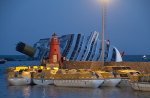
The Costa Concordia rests on its side on the morning of January 14, 2012.

 The Costa Concordia rests on its side on the morning of January 14, 2012 (click for larger photo)

 Yes, it is a photo of the Costa Concordia, aground on the rocks, but did anyone else notice the lighthouse in the photo under which the lifeboats are all clustered? See my article Lighthouses Visible in the Costa Concordia Disaster.

*************************

Aniva RockAniva rock [private]Sakhalinskaya Oblast, Russia[/private]- A formal penal island used by the Russians, Aniva was once sought after by both the Russia and Japan. This now Russian controlled territory sits uninhabited in the seas between Japan and the eastern coast of Russia.

This photo story appeared on Distractify and was entitled The 38 Most Haunting Abandoned Places On Earth. For Some Reason, I Can’t Look Away… Continue reading Mise Tales Thirty-Four

Weather Reporting at Boat Bluff c. 2004

The Lightkeeper – many years ago he had no contact with anyone – now the whole world can communicate with him and through him! 

Around 2004 the Canadian government decided to limit the weather report information put out by the lighthouse keepers to a very restricted set of criteria. 

Wind detecting devices (anemometers) were removed, pressure detecting devices (barometers) were removed and devices for measuring cloud height (ceilometers) were also removed. Basic weather training was kept to a minimum. The lightkeeper was left to his own devices to observe and report the weather every three hours to his designated Coast Guard radio station. 

No one was interested or affected . . . except those that used the weather reports! – the aircraft pilots, cruise ships, fishing boats, recreational boaters, and others that travelled the wind-swept and storm-lashed west coast of British Columbia. This coast is over 7,000 kilometres long from Vancouver, BC to Alaska, USA if you follow all its indentations, and sometimes these indentations are a life-saver when a storm blows up. (see the article Why We Need MORE Lighthouses . . .) Continue reading Weather Reporting at Boat Bluff c. 2004

BC Lightships

Thomas F. Bayard Sandheads No. 16 - photograph Canadian Coast Guard


Canada had lightships – well, I know of one on the Fraser River – the Sandheads #16. It used to be situated at the mouth of the Fraser River. More information on the Sandheads Lightships here.


The website Vancouver History has this to say:

The Sandheads #16 lightship at the mouth of the Fraser, there since 1913, ended its service. This two-masted schooner had started life in New York in 1880 as the Thomas F. Bayard, a Delaware Bay pilot ship. (Thomas Bayard was a Delaware senator.) She had an interesting career, which can be read about here. The Bayard was purchased in 1978 by the Vancouver Maritime Museum, which has been restoring her to her condition as a West Coast sealer. Continue reading BC Lightships

In Memorium – Prospect Point Lighthouse – Automated!

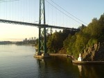
Prospect Point Lighthouse

Latitude 49 18 50.4N, Longitude 123 08 29.1W       List of Lights #392 

Established: October 01, 1888       Automated: January 1926 

Three nautical miles east of Point Atkinson, situated at the base of a cliff, stands the lonely and short-lived lighthouse called Prospect Point.

The light was first manned in October 1888 and was overshadowed by the importance of the Signal Station on the cliff above. This signal station operated in conjunction with Brockton Point  to signal when ships were coming into or out of Vancouver Harbour. 

In January 1926 the poor lightkeeper was informed by the Department of Marine and Fisheries that the lighthouse would be electrified and would then be operated by the Prospect Point Signal Station. He was out of a job after years keeping both systems working.

Prospect Point Lighthouse keeper’s house 1920 – 1930
Photo by Cyril R. Littlebury from Dudley Booth Collection

Prospect Point Lighthouse (bottom) Signal Station (top)
Photo by Cyril R. Littlebury from Dudley Booth Collection

Princess Victoria passing Prospect inbound 1920 – 1930
Photo by Cyril R. Littlebury from Dudley Booth Collection

Princess Patricia Passing Prospect 1920 – 1930
Photo by Cyril R. Littlebury from Dudley Booth Collection

SS Prince Rupert Passing Prospect 1920 – 1930
Photo by Cyril R. Littlebury from Dudley Booth Collection


Prospect Point Signal Station 1920 – 1930
Photo by Cyril R. Littlebury from Dudley Booth Collection

The photo below shows what replaced the lighthouse – a concrete block structure with a light on top and several small electric foghorns.


Prospect Point 2006
Photo from Imran Flickr pages


Prospect Point 2006
Modern light, modern ship
Photo from pwhsu48 Webshots page.

As mentioned above, the Prospect Point and Brockton Point signal stations monitored ship traffic in and out of Vancouver harbour. 

Just across the harbour from Prospect Point, at the mouth of the Capilano river, was the tiny little-known Capilano lighthouse (aka First Narrows). (see Capilano webpage here.

Below is a photo taken from the mouth of the Capilano River showing Prospect Point today and the the probable view from the Capilano lighthouse. Beside it is a Google Earth map showing the exact location of the three lighthouses. 

Prospect Point 2006 From mouth of Capilano river
Notice – no signal station
Photo from Glamorous_Life Flickr page.

Google Earth map Showing Vancouver harbour lights
Photo from Google Earth printout.

In this 360° view you can see Prospect Point off the right-hand side of the bridge. As the scene sweeps across the harbour, The sandbanks of the Capilano River come into view with the dolphin visible in deeper water. (Zoom in using Shift, and out with Ctrl key; Pause by clicking on photo).

Keepers
John Grove PLK (1888-1926)  

Travel – Australian Lighthouses

Shine a Light on Australia's lighthouses.


I came across this article that shows the life on an Australian lighthouse starting in 1971. A wee bit different than Canada I must say.


What got my attention were the requirements for a lighthouse keeper:

The job requirements of a lighthouse keeper were a car licence, an ability to climb to heights and an ability to get along with the other lighthouse keeper . . .

 The article is worth reading to illustrate the differences between Canadian and Australian lights (wildlife, for one), plus, on the page is a reference and a link to an ABC (Australian Broadcasting Corporation) website which is exploring some of Australia’s iconic lighthouses.

This new site is called Shining a Light and is an excellent documentary on some of Australia’s lighthouses. The map above shows the lighthouses mentioned.

There you go – two stories for one price. Enjoy!

Royal Sovereign Lighthouse – very unique!

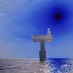
The photo below from the Guardian.uk does not  show the lighthouse very well, but the photo was so unique I had to post it. More photos can be seen on this Google Search here. That would have been a fun place to live. Wonder what it was like in windy weather?

Rozal Sovereign lighthouse

– from Wikipedia article here.

Royal Sovereign lighthouse at Eastbourne is a lighthouse marking the Royal Sovereign shoal. Its distinctive shape is easily recognised as it comprises a large platform supported by a single pillar rising out of the water.

The lighthouse replaced a light vessel which protected the Royal Sovereign Shoal since 1875. Originally, the platform was manned, accommodation being contained in the ‘cabin section’, a practice which ceased in 1994 when the light was automated.