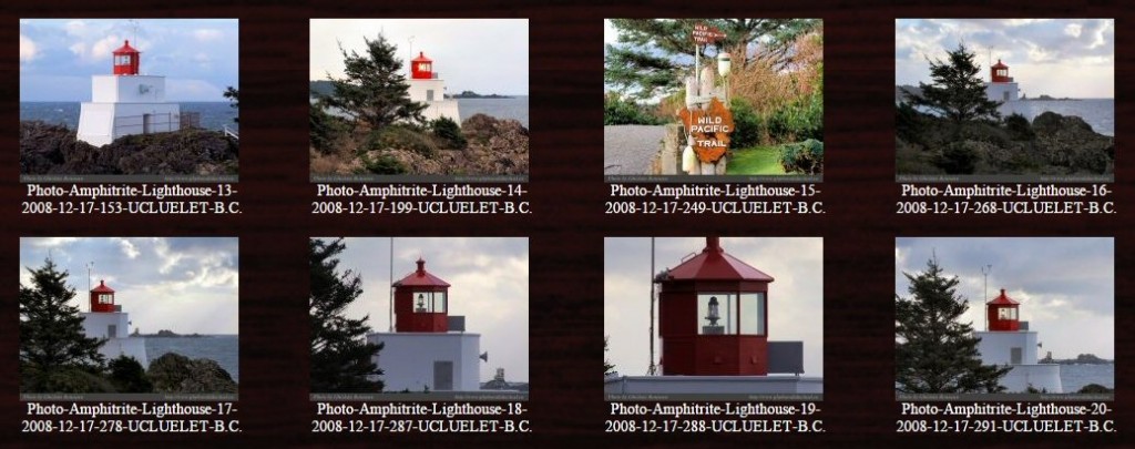
Amphitrite Lighthouse is located on the west coast of Vancouver Island, British Columbia, Canada. It is automated and closed to the public, but one can get close enough for photos. The photos above (all 80 of them) were taken by my friend Ghislain Bonneau, a west coast painter and photographer. Continue reading Amphitrite Lighthouse→
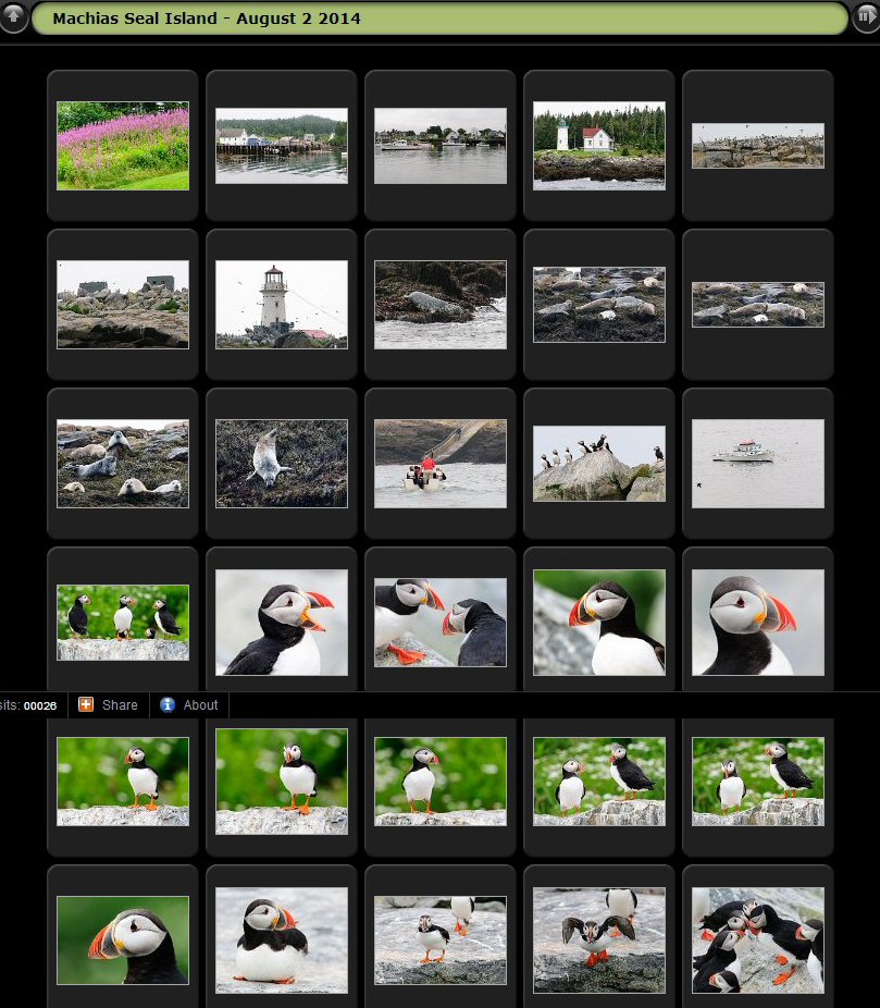
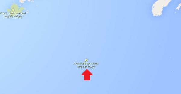
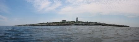
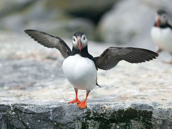
Machias Seal Island is located on the East coast of Canada between New Brunswick and Maine. It is best known for its bird populations – especially puffins – and also for its ongoing border dispute between Canada and the USA. Thi taken s morning I was notified of a lovely photo album taken this month at the island. It is quite a lovely place, but the light tower does need repainting, especially as it is symbolically representing Canada!
To navigate, click on a thumbnail photo and then when it opens, click on the arrows at upper right of page.
More photos of the light and island here on a Google Image Search. Historical information here in Wikipedia. Enjoy!
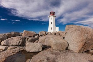
Having grown up in Nova Scotia, I have fond memories of scrambling over the curved granite whaleback rocks below my aunt’s cottage near the community of Peggy’s Cove.
Even though that’s the home of Nova Scotia’s most famous landmark, Peggy’s Point Lighthouse, I didn’t pay much attention to the lighthouse in those days. The tide pools and shallow caves of the whalebacks were more enticing. As an adult, however, I’ve grown to appreciate and cherish these beautiful beacons and the maritime tradition they represent. . . . more
Editor’s Note: Find additional information on Quebec, Newfoundland and Prince Edward Island lighthouses, along with ideas for exploring the surrounding towns, right here on our blog!
And be sure to read John Sylvester’s new eBook: A Photographer’s Guide to Prince Edward Island, a downloadable PDF for mobile devices, available at: www.photographersguidetopei.com.
[private]
As long as humans have sailed the oceans, we’ve needed navigational aids to warn of hidden shoals and dangerous headlands. The earliest warning lights were coastal bonfires. The first known lighthouse was built at Alexandria, Egypt, around 280 B.C. The British built North America’s first one at the entrance to Boston Harbor in 1716. The French followed 15 years later with Canada’s first lighthouse near their fortress at Louisbourg on what is now Nova Scotia’s Cape Breton Island.
Peggy’s Point Lighthouse (Photo: John Sylvester)
In sailing’s golden age, from the 1700s to the mid-19th century, lighthouses proliferated along the Atlantic coast. In Atlantic Canada alone, nearly 500 still stand along 33,000 miles of mainland and island coastline. A few miles up the coast from Peggy’s Cove, North America’s oldest continuously operating light, Sambro Island Lighthouse, stands on a tiny granite outcrop at the entrance to Halifax Harbor. Built in 1758, its eye-catching 80-foot red-and-white tower has been the first sign of land seen by countless sailors, immigrants and ocean liner passengers—including the Titanic survivors—as they approached the safety of landfall.
During the heyday of maritime activity, lighthouse keepers and their families lived in homes either attached to or close by the lighthouse. They often had to fend for themselves in isolated circumstances, growing a garden and raising livestock in addition to their full-time duties tending the light. Every evening, in fair weather or foul, the light keeper climbed a narrow, winding staircase to the top of the tower to light the lamp, located behind a powerful Fresnel lens that magnified and transmitted the beam far out to sea.
Light keepers eventually lost their jobs to automation, and in recent years sophisticated GPS navigation systems have rendered lighthouses redundant. Some have fallen into disrepair, but many have been rescued by local preservation or historical societies and converted into museums or tourist attractions.
Thanks to broad grassroots support, the federal government passed an act encouraging lighthouse preservation. But Natalie Bull, executive director of Heritage Canada The National Trust, notes that the legislation ultimately says it’s up to communities to protect their lighthouses.
Bay of Fundy Lighthouse (Photo: John Sylvester)
“It’s very challenging, but residents of the Maritime Provinces are resourceful,” she adds. “Community groups have long been willing to take on these preservation projects, even before the act passed. New Brunswick’s Cape Enrage Lighthouse is a great example.”
The Cape Enrage keepers house was slated to be torn down when, in 1993, a group of local high school kids and their physics teacher started renovating it. Two years later the Coast Guard transfered ownership to the province, and the site is now the hub of a thriving adventure tourism destination that includes kayaking, rock climbing and horseback riding.
The wonderful thing about lighthouses, of course, is that they’re invariably built on beautiful coastal stretches. Some have been converted into inns where you can rent a room overlooking the ocean, listen to the waves lapping the shore and imagine life in a bygone era. You can now find lighthouse inns in all five of the provinces on Canada’s Atlantic Coast.
Quirpon Island Lighthouse (Photo: John Sylvester)
A few years ago I clambered into a small fishing boat that transported me to remote Quirpon Island off the north coast of Newfoundland, where I stayed in a cozy inn that was a former light keeper’s cottage. I spent two glorious days exploring the island, watching whales and sculpted icebergs drift by, and being pampered with Newfoundland’s renowned hospitality.
But even when I can’t spend the night, I rarely pass up a chance to visit one of these inviting beacons. On a recent trip to Nova Scotia, my wife and I drove out to Peggy’s Point Lighthouse on a beautiful autumn day. We joined tourists from all over the world wandering among the same whaleback rocks that fascinated me as a child.
We lingered through the afternoon, enjoying the timeless wonder of waves breaking on the rocks and sunlight sparkling off the ocean while one of Canada’s most beloved symbols of a proud seafaring tradition stood watch. And this time, I knew enough to appreciate it.
John Sylvester is an author and photographer based in Prince Edward Island, Canada. He specializes in photographing the people and places of Canada, and has published extensively on the Atlantic region, including the great lighthouses.
Cape d’Or Lighthouse (Photo: John Sylvester)
An ice flow off Newfoundland (Photo: John Sylvester)
Sunset at Fortune Head Lighthouse (Photo: John Sylvester)
I have mentioned Machias Seal Island before in my articles here, here, here, and here.
Well writer John Farrier published on Neatorama on Tuesday, April 22, 2014 a great article about how MAJOR/insignificant this dispute really is!
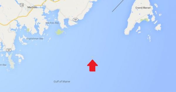
(Maps: Google Maps)
This is Machias Seal Island, a 20-acre island in the Bay of Fundy.
You can’t see it? Let’s zoom in.
And from there the story continues! Such an insignificant island for such a big debate. That is government for you. Naturally it belongs to Canada! . . . more
[private]
Hmm. That doesn’t help much. Let’s zoom in some more.
There it is! It’s a speck of land that barely appears on the map.
The ownership of Machias Seal Island is disputed by the United States and Canada. Canada is in physical possession of it, but the United States has not formally dropped its claim to the island.
I’ve previously written several posts about the development of the US-Canadian border, whichincludesweirdexclaves. Ambiguity about the border even led to the creation of 2 short-lived nations.
(Painting by Benjamin West of the American delegation at the Treaty of Paris)
Although the United States and Canada now maintain a long, peaceful border, the placement of that border has been in doubt since the Treaty of Paris (1783) in which Britain recognized the United States as an independent nation. That treaty attempted to draw borders over unexplored lands. The authors did the best that they could with their knowledge of geography. But, alas, one of the descriptions for the border between Maine and maritime Canada was problematic. The treaty says that US territory includes:
all Islands within twenty Leagues of any Part of the Shores of the United States, and lying between Lines to be drawn due East from the Points where the aforesaid Boundaries between Nova Scotia on the one Part and East Florida on the other shall, respectively, touch the Bay of Fundy and the Atlantic Ocean, excepting such Islands as now are or heretofore have been within the limits of the said Province of Nova Scotia.
I’ve bolded the parts of the text that are the source for the Machias Seal Island dispute.
As I’ve mentioned in a previous post, the eastern border of Maine was of great concern to the British. Some British officials coveted what Americans saw as their territory, and vice versa. Control of the Bay of Fundy was of great importance to British commissioners at the Treaty of Ghent (1814), which ended the War of 1812.
Now back to Machias Seal Island. The American argument is that it lies within 20 leagues (approximately 69 miles) of the coast of the United States.
The Canadian argument is that a land grant that pre-exists the Treaty of Paris defines the island as part of Nova Scotia. It built and has operated a lighthouse on the island since 1832.
Occasionally fishermen from the 2 nations have gotten into scraps about its ownership. Some Canadian citizens have staked mining claims to the island as a means of asserting Canadian sovereignty. The State of Maine has included the island on its maps of electoral districts.
But if possession is indeed 9/10ths of the law, then Machias Seal Island is Canadian. The United States has chosen not to press the issue.
For an update on what a Mise Tale is then please see Mise Tales One. As mentioned earlier on the front page of my website, any photos or cartoons, or short bits of information, when it is removed from the front page, will also be included again later in the next Misc Tales. That way you can keep track of it, search for it, or copy it.
*****************************
survival necklace s1401 from Cougar Fashion in Tahsis, British Columbia
from the rainforest, for the rainforestprice $12.50this necklace is transformed to emergency fishing gear within minutes. all you need is a pocket knife.
contents: – 3.8 m. fishing line – 3.5 cm. bait hook – interlock snap swivel – split ring – 6 cm. hoochie
Now this is a unique West Coast piece. It is a very beautiful necklace and would draw comments wherever it is worn. I am not too sure how practical it would be with only 3.8 meters (12.5 feet) of fishing line, but anything could work in an emergency.One would be better off also wearing a Survival Strap (get one in a matching colour) to add length to the necklace. Hey, two unique pieces of survival jewelry which you can wear anytime. Check out all the other items which you can find at Cougar Fashion. Continue reading Mise Tales Forty→
For an update on what a Mise Tale is then please see Mise Tales One.
As mentioned earlier on the front page of my website, any photos or cartoons, or short information will also be included again later in the next Misc Tales when it is removed from the front page. That way you can keep track of it, or copy it.
*****************************
Lovely night sky photographs including a couple with lighthouses, all by Miguel Claro.
[private]
[/private]
*****************************
An excellent interactive article on Explore Canada’s ocean watersheds from Canadian Geographic. It shows how dependent we all are on our water supplies – from source to oceans. Keep them clean!
*************************
A song sent to me on Facebook by my cousin. Lyrics are here.
****************************
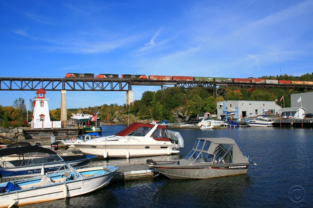
Two things I love best – lighthouses and trains!
From the site Railpictures.ca – CN 8839 with the 6018 and 8808 lead a northbound train at mile 22.7 on the CP’s Parry Sound Sub September 26, 2008
The majority of lighthouses shown in this book are American, but as a friend of mine wrote:
I received a lighthouse book for Christmas – from an ex -lighthouse keeper and I groaned when I opened the parcel. “Oh yes, forty photos of Portland bloody Head I suppose.” No, well yes, a couple, but Canadian lights and British Columbia lights – 4 pages on West Vancouver’s Pt. Atkinson, plus photo of Cape Mudge, and for comic relief Brockton Point (Stanley Park). – thanks JDR
So, not all bad news. The book is not coffee table format so it will fit easily on your bookshelf.
Lighthouses of North America – Beacons from Coast to Coast
Facing the Sea: Lightkeepers and Their Families By Harold Chubbs and Wade Kearley Foreword by Lorne Humphries Genre: History: General Imprint: Flanker Press Format: Hardcover, 132 pages, colour photos and illustrations Pub Date: October 2013 Price: $34.95 ISBN-10: 1-77117-301-7 ISBN-13: 978-1-77117-301-8 Shipping Weight: 0.9 kg
About this Book In Facing the Sea, authors Harold Chubbs and Wade Kearley have captured an important era in the maritime history of Newfoundland and Labrador. These tales of rescue and tragedy, of love lost and redeemed, describe first-hand what life was like for lightkeepers and their families in twenty-five light stations along the exposed and often inhospitable coast of Newfoundland and Labrador. Most of these stories are told here for the first time in print, and each story is rich with new details and insights from the perspective of these remarkable men and women. Order Now!
My title here Message in a Bottle is also the title of a 1999 American romantic drama film directed by Luis Mandoki and based on a novel with the same name by Nicholas Sparks, but in this case it refers to something completely different!
Most people think of a message in a bottle as a beachcomber’s mystery find. In this case there was no mystery, but lots of adventure! The story was posted on the MR BONE HEADFacebook page. You never know what you will find on the beach!
Judi and the message bottle – photo – Glunz Ocean Beach Hotel & Resort
So one of our owners Judi was walking on the beach this morning cleaning up the junk that washed into shore and finds a bottle with a message in it. There is also some sand and 2 one dollar bills.
Once we get it open and read the notes we find out that it is in fact NOT sand. It is the ashes of this woman’s husband of 70 years named Gordon. She writes that He loved to travel so she sent him traveling in a bottle with a note and money for someone to call home and tell her where he landed.
He started at Big Pine Key [Florida] (point A on the map below) in March of 2012 and then went to Islamerada [Florida] (point B) where someone found him. They added a note and sent him traveling again and he landed on our beach in Key Colony (point C).
Judi called the wife in Tennessee who was excited to know of Gordon’s travels! Judi added her note, we put him in a rum bottle (you know added a little fun to his trip) with the three notes. We added another dollar in case Gordon travels far and a long distance call is needed.
We will be having a memorial service or celebration of his life on our beach later today before sending him on his way again. Only our sister Judi could find a dead guy on our beach!


