Category Archives: Foreign

Reprint – Poro Point Lighthouse, a Light for Prosperity


Philippine Information Agency (PIA)

Poro Point Lighthouse, a light for prosperity

By Jennilyne C. Role Monday 23rd of April 2012 

Poro Point, La Union, Philippines
The Poro Point Lighthouse in La Union was built in 1885 during the Spanish colonial era to serve as beacon for ships and boats plying the sea at night. Bounded on the west by the west Philippine sea and on the east by the San Fernando bay, its apex is the highest elevation of the peninsula, and allows an unobstructed view of the panoramic landscape. 

At the lighthouse, one can experience the beautiful sunrises and sunsets La Union is known for, while overlooking the undulating greens of the beautiful ‘The Cliffs Golf Course’ of Thunderbird Resorts and a coastline of pristine white sand. Atop the Poro Point Lighthouse, a tourist gets a glimpse of the best that Poto Point can offer. 

Thus, the Poro Point Lighthouse is the perfect symbolism of the Poro Point Freeport Zone (PPFZ). 

Featuring the Poro Point Lighthouse, a festival was conceptualized, in comparison with the ‘Panagbenga’ or the Flower Festival of Baguio City and the ‘Hot Air Balloon Festival’ of Clark. Dubbed as “SILLAG – The Poro Point Festival of Lights”, the festival, which will be launched on April 28, aims to boost the economic activities of the province and the whole region as a whole. 

‘Sillag’ is an Iloco word which means moonbeam or illumination from the moon, and is similarly compared to the region’s booming business climate. 

It is initiated by the Poro Point Management Corporation (PPMC), a member of the Bases Conversion and Development Authority Group which aims to promote the 6-hectare lighthouse property as a vital component of an Integrated Tourism Complex and attract domestic and tourists to create a mass market to encourage business and commerce in the PPFZ. 

The ‘Sillag’ festival components include the following: 

FLUVIAL PARADE – This is the highlight of the festival which will feature illuminated and decorated boats from participating government entities, business firms, and various stakeholders. 

HOPE LANTERNS – The lanterns will be sold to government agencies, business firms, schools, various groups and organizations as well as individuals which will be released after the fluvial parade. Proceeds of which will go the PPMCs HELPS, a Corporate Social Responsibility Program of the corporation. HELPS stands for Health, Education and Environment, Livelihood Program including employment opportunities within the zone, and Strengthening Linkages. 

MOA signing at the LIGHTHOUSE – The MOA covers the ‘Adopt-A-Lighthouse Project’ between PPMC and the Philippine Coast Guard (PCG). According to PPMC President and CEO Florante Gerdan, all lighthouses under the law is owned by the PCG. However, with the festival initiative, the PPMC requested PCG to handle and maintain the Poro Point Lighthouse. 

UNVEILING OF THE CANVASS – The canvass will show the planned transformation of the lighthouse area. It will highlight the Spanish lighthouse, the renovated modern lighthouse, and refurbished shotgun house which could possibly be a museum and a souvenir shop at the same time. 

It is also proposed in the UP Planades Development Framework Plan for the area that a multi-level observatory/viewing decks ending in circular platforms will be built that would serve as access points to water sports activities. 

The six-hectare area will be built with restaurants, specialty shops, and green and open spaces, Gerdan said. 

Other scheduled activities for the festival are concert featuring two bands; pyromusical show; children’s show featuring clown, magicians, jugglers and others to create a more festive atmosphere. 

To draw more tourists, the scheduled one-day initial festival offers free rides to the area which is expected to be more complex and more exciting the coming years. (JCR-PIA 1, La Union) 

Mise Tales Eighteen


For an update on what a Mise Tale is then please see Mise Tales One.

Build a Redstone Lighthouse in Minecraft

This article may be a bit outside the scope of this website, but then maybe not.

Everybody loves a lighthouse, whether it is on the sea, in your garden or in your computer as is this PC/Mac program called Minecraft. This may not be to everybody’s interest but I am sure there are a few of my readers out there who play the game and might be interested.

I have never explored Minecraft, but a short description will more than help you understand the fascination. I might even give it a try. You all know my fascination with Lego!

Minecraft: What The Hell It Is

The literal description: Minecraft is a first-person, free to play indie PC/Mac game created by one person, with crafting, building and exploration at its center. The graphics are straight out of 1991. There are no characters and there is no story. There are none of the “production values” that define gaming these days, but within those narrow confines lies one of the most innovative and endlessly fascinating game in existence… and it’s still in Alpha.

While there are various versions and builds available out, there are three basic play-modes to Minecraft: Single Player Creative, Multiplayer Creative, and Single Player Survival. All three plop you down into a huge, open world, filled with different natural resources you can exploit and bend to your will.

Single Player Creative mode is like an infinite LEGO set. You can create fantastic structures out of basic building blocks all day if you’d like. You can try it out for free, in-browser, right here. Multiplayer Creative is the same deal, with others. – g4tv.com

So, here is a short video on how to build a Minecraft lighthouse:

[media url=”http://www.youtube.com/watch?v=Ny5JxKwRtnI” width=”400″ height=”350″]
**************************** Continue reading Mise Tales Eighteen

An Island Dispute of our Own

An island dispute of our own
Posted By Joshua Keating  Wednesday, November 28, 2012 – 11:36 AM

It’s not quite the Senkakus, but Stephen Kelly highlights a long-festering territorial dispute between the United States and Canada:

Machias Seal Island is a 20-acre, treeless lump that sits nearly equidistant from Maine and New Brunswick. It, and the even smaller North Rock, lie in what local lobstermen call the gray zone, a 277-square-mile area of overlapping American and Canadian maritime claims.

The disagreement dates back to the 1783 Treaty of Paris that ended the Revolutionary War. The treaty assigned to the newly independent 13 colonies all islands within 20 leagues — about 70 miles — of the American shore. Since Machias Seal Island sits less than 10 miles from Maine, the American position has been that it is clearly United States soil.

But the treaty also excluded any island that had ever been part of Nova Scotia, and Canadians have pointed to a 17th-century British land grant they say proves the island was indeed part of that province, whose western portion became New Brunswick in the late 18th century.

Perhaps more important to the Canadian case, the British built a lighthouse on Machias Seal Island in 1832, which has been staffed ever since. Even today, two lighthouse keepers are regularly flown to the island by helicopter for 28-day shifts to operate a light — even though, like every other lighthouse in Canada, it is automated. – Opinion Pages – NY Times

[private]

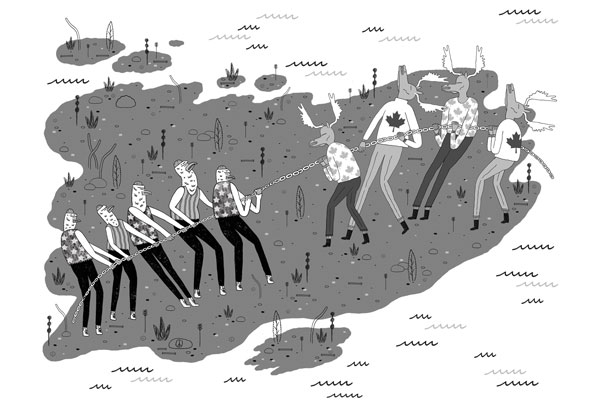
The New York Times Opinion pages Good Neighbors, Bad Border Cartoon: John Malta
By STEPHEN R. KELLY   Published: November 26, 2012

AT a time when territorial disputes over uninhabited outcrops in the East China Sea have led to smashed cars and skulls in China, a similar, if less dramatic, dispute over two remote rocks in the Gulf of Maine smolders between the United States and Canada.

Machias Seal Island and nearby North Rock are the only pieces of land that the two countries both claim after more than 230 years of vigorous and sometimes violent border-making between them.

Except for the occasional jousting of lobster boats, this boundary dispute floats far below the surface of public or official attention, no doubt reflecting the apparent lack of valuable natural resources and a reluctance to cede territory, no matter how small.

But if we are unlikely to resort to arms anytime soon, the clashes in Asia have shown how seemingly minor border disputes can suddenly stoke regional and nationalistic tensions. Our relaxed attitude toward these remote rocks may well be a mistake.

While the United States and Canada have other maritime boundary disputes along their 5,525-mile border, the world’s longest, this is the only one left that involves actual chunks of land.

Machias Seal Island is a 20-acre, treeless lump that sits nearly equidistant from Maine and New Brunswick. It, and the even smaller North Rock, lie in what local lobstermen call the gray zone, a 277-square-mile area of overlapping American and Canadian maritime claims.

The disagreement dates back to the 1783 Treaty of Paris that ended the Revolutionary War. The treaty assigned to the newly independent 13 colonies all islands within 20 leagues — about 70 miles — of the American shore. Since Machias Seal Island sits less than 10 miles from Maine, the American position has been that it is clearly United States soil.

But the treaty also excluded any island that had ever been part of Nova Scotia, and Canadians have pointed to a 17th-century British land grant they say proves the island was indeed part of that province, whose western portion became New Brunswick in the late 18th century.

Perhaps more important to the Canadian case, the British built a lighthouse on Machias Seal Island in 1832, which has been staffed ever since. Even today, two lighthouse keepers are regularly flown to the island by helicopter for 28-day shifts to operate a light — even though, like every other lighthouse in Canada, it is automated.

While abundant legal arguments surround Machias Seal Island, natural resources are far less evident. No oil or natural gas has been discovered in the area, nor has it had any strategic significance since it served as a lookout for German U-boats during World War I.

Tour boats from Maine and New Brunswick carry strictly limited numbers of bird watchers to the island to see nesting Atlantic puffins. And the surrounding waters contain lobsters that, thanks to different regulatory schemes and overlapping claims, have occasionally sparked clashes between Maine and New Brunswick lobstermen, although a bumper lobster crop this summer has slackened demand for gray zone crustaceans.

But the lack of hydrocarbons and the current lobster glut make this an ideal time to color in the gray zone.

The United States and Canada settled all their other maritime differences in the Gulf of Maine in 1984 by submitting their claims to the International Court of Justice for arbitration. They could have included the gray zone in that case, but did not. The Canadians had refused an earlier American arbitration proposal by saying their case was so strong that agreeing to arbitration would bring their title into question.

This attitude calls for re-examination. The fact that so little in the way of resources appears to be at stake, far from justifying the status quo, should be the main reason for resolving the issue. And for those concerned about blowback from “giving away” territory, letting the international court decide the case provides the most political cover.

As China and Japan can attest, border disputes do not go away; they fester. And when other factors push them back to the surface — the discovery of valuable resources, an assertion of national pride, a mishap at sea — the stakes can suddenly rise to a point where easy solutions become impossible.

Before that happens, we should put this last land dispute behind us, and earn our reputation for running the longest peaceful border in the world.

Stephen R. Kelly is the associate director of the Center for Canadian Studies at Duke University and a retired American diplomat who served twice in Canada.

A version of this op-ed appeared in print on November 27, 2012, on page A31 of the New York edition with the headline: Good Neighbors, Bad Border.

[/private]

[private] An island dispute of our ownPosted By Joshua Keating  Wednesday, November 28, 2012 – 11:36 AM  
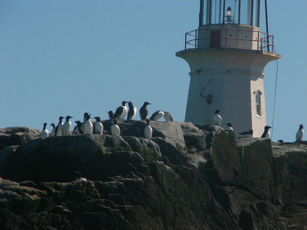
It’s not quite the Senkakus, but Stephen Kelly highlights a long-festering territorial dispute between the United States and Canada:

Machias Seal Island is a 20-acre, treeless lump that sits nearly equidistant from Maine and New Brunswick. It, and the even smaller North Rock, lie in what local lobstermen call the gray zone, a 277-square-mile area of overlapping American and Canadian maritime claims.

The disagreement dates back to the 1783 Treaty of Paris that ended the Revolutionary War. The treaty assigned to the newly independent 13 colonies all islands within 20 leagues — about 70 miles — of the American shore. Since Machias Seal Island sits less than 10 miles from Maine, the American position has been that it is clearly United States soil.

But the treaty also excluded any island that had ever been part of Nova Scotia, and Canadians have pointed to a 17th-century British land grant they say proves the island was indeed part of that province, whose western portion became New Brunswick in the late 18th century.

Perhaps more important to the Canadian case, the British built a lighthouse on Machias Seal Island in 1832, which has been staffed ever since. Even today, two lighthouse keepers are regularly flown to the island by helicopter for 28-day shifts to operate a light — even though, like every other lighthouse in Canada, it is automated.

Kelly reasonably suspects that the lack of natural resources in the region have made both sides reluctant to rock the boat by submitting their claims to the International Court of Justice for arbitration, as they have with other disputes. There’s simply nothing there worth the risk of losing the case and having to explain to voters why you “gave away” U.S. or Canadian territory. In any case, from the photos on Flickr it looks like the Canadian government has staked a pretty permanent claim to the island, so this one may be de facto settled.

Machias is the only U.S.-Canadian border conflict that involves land, but the sea border is disputed in a few places. Here’s Wikipedia’s list:

  • Strait of Juan de Fuca 48°17?58?N 124°02?58?W (Washington /British Columbia) The middle-water line is the boundary, but the governments of both Canada and British Columbia disagree and support two differing boundary definitions that would extend the line into the Pacific Ocean to provide a more definite Exclusive Economic Zone (EEZ) boundary.
  • Dixon Entrance 54°22?N 132°20?W (Alaska / British Columbia) is wholly administered by Canada as part of its territorial waters, but the US supports a middle-water line boundary, thereby providing the US more maritime waters. Canada claims that a 1903 treaty demarcation is the international maritime boundary, while the United States holds that the maritime boundary is an equidistant line between the islands that form the Dixon Entrance, extending as far east as the middle-water line with Hecate Strait to the south and Clarence Strait to the north.[2]
  • Yukon–Alaska disputeBeaufort Sea 72°01?40?N 137°02?30?W(Alaska / Yukon) Canada supports an extension into the sea of the land boundary between Yukon and Alaska. The US does not, but instead supports an extended sea boundary into the Canadian portion of the Beaufort Sea. Such a demarcation means that a minor portion of Northwest Territories EEZ in the polar region is claimed by Alaska, because the EEZ boundary between Northwest Territories and Yukon follows a straight north-south line into the sea. US claims would create a triangular shaped EEZ for Yukon. This is mainly an Alaska-Yukon dispute.
  • Northwest Passage; Canada claims the passage as part of its “internal waters” belonging to Canada, while the United States regards it as an “international strait” (a strait accommodating open international traffic).

The last two might get a bit more controversial as resource competition in the rapidly melting Arctic heats up.

[/private]
The Lighthouse of Maracaibo


What is the Lighthouse of Maracaibo? Where is it?

Well, first of all it is not a lighthouse, so if you are not interested please continue on to another article, but I think you will find this fascinating.


View Larger Map

Why is then called a lighthouse? Well, it can be seen from many miles away for over 160 nights a year over Lake Maracaibo in Venezuela. I would never have known about it except that my article antennae are tuned to anything lighthouse. When I heard about it, I just had to investigate and bring it to your attention. This is quite unique and the only place in the world that has this phenomena in such intensity.

It is said to have the hottest flash density rate in the world, with an annual average of 181 lightning flashes per square kilometre.During peak months there can be as many as fifty (50) discharges every minute. That is a nearly continuous thunderstorm with up to 20,000 flashes of lightning per night. That is a lot of lightning – the most persistent thunderstorm of the world!

From Wikipedia:

The storms (and associated lightning) are likely the result of the winds blowing across the Maracaibo Lake and surrounding swampy plains. These air masses inevitably meet the high mountain ridges of the Andes, the Perijá Mountains (3,750m), and Mérida’s Cordillera, enclosing the plain from three sides. The heat and moisture collected across the plains creates electrical charges and, as the air masses are destabilized at the mountain ridges, result in almost continual thunderstorm activity.

The phenomenon is characterized by almost continuous lightning, mostly within the clouds, which is produced in a large vertical development of clouds that form large electric arcs between 2 and 10 km in height (or more). The lightning tends to start approximately one hour after dusk.

Among the major modern studies there is the one done by Melchor Centeno, who attributes the origin of the thunderstorms to closed wind circulation in the region.

[media url=”http://www.youtube.com/watch?v=zRvpM01VTFU” width=”400″ height=”350″]

Mise Tales Seventeen

For an update on what a Mise Tale is then please see Mise Tales One.

Power supply resumes at Unoosaki lighthouse in Soma
2 November 2012
The Unoosaki lighthouse in Soma, Fukushima Prefecture, has resumed full operations after power was restored 19 months after the March 11, 2011, earthquake and tsunami.

As a result, the lighthouse is now fully able to help ships safely navigate the waters off Fukushima Prefecture.

The Japan Coast Guard’s office in the prefecture, the Fukushima Coast Guard Office, unveiled the lighthouse to the media on Nov. 1, which is observed as “lighthouse day” in Japan [I did not know that!]. . . . more

***********************************

“Bubble Delight” by Cecile & Ronaldo Lobo of Bridgeport
“For the Birds” by John Sudell of Greenwich

 Bridgeport couple’s lighthouse on display at Maritime Aquarium

A model lighthouse made by a Bridgeport couple is helping to light the way for visitors in The Maritime Aquarium at Norwalk as part of the aquarium’s 11th annual “Festival of Lighthouses.” – more

  Continue reading Mise Tales Seventeen

Reprint – “Stand” – An Adventure Documentary


Stand – Power Teaser

 [media url=”http://vimeo.com/52119128″ width=”400″ height=”350″]

[private]https://ccanadaht3.com/wp-content/uploads/2012/11/Vimeo-.mp4[/private]

 from  PLUS


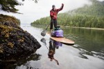
STAND, presented by Quiksilver Waterman, will take viewers on a journey through the waters of B.C.’s west coast. Through the stories of an aboriginal high school class building their own stand-up paddleboards as a form of protest, the efforts of expedition stand-up paddler Norm Hann, and the powerful surfing of iconic west coast native Raph Bruhwiler, the diversity of people, landscape and wildlife that would be affected by an oil spill
will be articulated. STAND will take you to the core of the issue and unfurl the soul of B.C.’s west coast one paddle stroke at a time.

Cedar Standup Paddleboard

The crew is currently raising funds through the popular crowd-sourcing platform IndieGoGo, in order to complete post-production and bring this story into the mainstream consciousness. You can become a champion of the Great Bear and help protect our precious coastlines by donating to the project and in return receive some great rewards.

IndieGoGo Fundraiser: indiegogo.com/standfilm

Created by Anthony Bonello and Nicolas Teichrob

Music:
Original Score by Alan Poettcker (myspace.com/thesekidswearcrowns)

Sound Design:
Gregor Phillips (cinescopesound.com/)

Cinematography: Anthony Bonello and Nicolas Teichrob
Editing: Nicolas Teichrob

Additional footage courtesy of:
Adam DeWolfe (adamdewolfe.com)
Pacific Wild (pacificwild.org)
Peter Yonemori

***************************

STAND – a SUP adventure through the Great Bear Rainforest

 [media url=”http://vimeo.com/38708656″ width=”400″ height=”350″]

[private]https://ccanadaht3.com/wp-content/uploads/2012/11/stand_-_a_sup_adventure_through_the_great_bear_rainforest_1280x720.mp4[/private]

October 23, 2012 –  “STAND” the new film from b4apres Media in association with Dendrite Studios will take you into the heart of the largest temperate rainforest on the planet—the Great Bear in British Columbia, Canada. Hung on the skeleton of a good ol’ fashioned adventure undertaken by a group of surfers, the potential effects of introducing super tankers to these pristine waters will be articulated. As the crew moves through this remote region under their own power, the landscape will be unfurled one paddle stroke at a time and punctuated by the faces and fears of the First Nation people who call this garden of Eden their home. Not just an efficient mode of transport, a stand up paddleboard expedition will be symbolic of “standing up” to preserve this last bastion of rainforest. Captured in cinematic High Definition, the film will bring the Enbridge Pipeline debate into the collective consciousness in a way that will have you fishing in your basement for that old fluorescent wetsuit.

Quiksilver Waterman has signed on as the presenting sponsor for STAND. Since the crew had the concept for the film last year, they have been searching for a partner to support the project. That partner, however, needed to be the right fit and believe in the cause, in protecting British Columbia’s West Coast. Thankfully Quiksilver Waterman along with the Quiksilver Foundation 1 share a strong commitment to the environment.

Norm Hann and Raph Bruhwhiler are both Quiksilver ambassadors and agreed to join the project from the beginning. Both are true waterman and dedicated to the protection of the waters that they derive so much enjoyment from as well as the occasional seafood platter. Having Quiksilver Waterman involved makes the perfect trilogy and will allows the filmmakers to illuminate the stories, adventures and landscapes that abound in this truly magic part of the world.

Long protected by the 1972 Trudeau government moratorium on crude oil tankers plying British Columbia’s north coast, these waters are now facing the risk of oil spill. Potentially, 225 Very Large Crude Carriers (VLCC) per year would each transport approximately 2 million barrells of oil through the Great Bear Rainforest. In context, today’s supertankers carry ten times the volume of the Exxon Valdez oil spill. Put simply, the pristine marine and terrestrial ecosystems as well as the people of the Great Bear would likely not recover from such an incident.

This issue is perhaps the most important environmental issue in B.C. history. Whats more, a catastrophic oil spill could reach beyond borders and impact much of the Pacific North West coastline.

Visit the official Dogwood Initiative Website to learn more and find out how to get involved.

August 21, 2013Go see the film in Toronto.

****************************

FOOTNOTE:

1 For years, Quiksilver and Roxy have been actively engaged in charitable activities, both locally and globally. Quiksilver recognises the concept of corporate social responsibility and benevolence. We want our philanthropic work to have impact beyond what we do as one company and believe that we can do this by coordinating the support of other organizations and individuals. The Quiksilver Foundation was formed to bring all of Quiksilver’s charitable giving under one umbrella. The Foundation commenced its activities as a private foundation in October of 2004.

With offices in Europe, Australia and America, Quiksilver has the capability of reaching people worldwide. Quiksilver has the vision of making a difference to community and environment through the Quiksilver Foundation.

The Quiksilver Foundation is a non-profit organization committed to benefiting and enhancing the quality of life for communities of boardriders across the world by supporting environmental, educational, health and youth-related projects.
The Quiksilver Foundation has a commitment to improve the quality of all our lives.
We desire to benefit:

Local Communities, including schools, local charities through support and outreach programs;

Major special projects and organizations sharing our focus on children, education, science, oceans and the environment.

Mise Tales Fifteen


For an update on what a Mise Tale is then please see Mise Tales One.

Some of these stories and articles are a bit late for Halloween, but better late than never, especially when lighthouses are a year-round topic!

The Fog – Best Scary Movie Starring Point Reyes Lighthouse

You may have heard of this John Carpenter film – myself, I have never seen it. I was going to write about it, but May, the author at Completely Coastal has done such a good job, I thought I would turn you over to her. Enjoy . . . [link]

A Northern California fishing town, built 100 years ago over an old leper colony, is the target for revenge by a killer fog containing zombie-like ghosts seeking revenge for their deaths. – Internet Movie Database (IMDb)

************************************

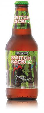
Lighthouse Switchback India Pale Ale (IPA)

The Province October 20, 2012

This is the first in a series of reviews on the new wave of British Columbia India Pale Ales (IPAs). This province already produces some Continue reading Mise Tales Fifteen

West Coast Recipes – Part One


I thought this might be interesting for people in other parts of the world who read this website. There are many food recipes associated with the West Coast of Canada and USA – many from the First Nations people, and many from the residents be they mariners, lighthouse keepers, villagers, prospectors, hunters or others. I will try and see what I can find. I will try and post about five (5) recipes per post. If others have any contributions, please pass them on. Full credit will be given.


One recipe I have posted can be found here: Thomas Crosby Muffins. Also a book was written about British Columbia lighthouses called The Lighthouse Cookbook by Anita Stewart. It is an excellent book and is available from Amazon.com.


******************************** 

1. Salmon Fish Cakes

Now this is one of the simplest recipes to make, and I learned about making them from my wife Karen who’s father used to cook them while out on the West Coast fishing for salmon. His recipe was pretty simple: Use whatever is available! Take some leftover cooked salmon, mix it about half and half with some leftover cooked potatoes, throw in an egg to help hold it together and season with salt and pepper. If available, add a few chopped green onions. Make into patties and fry in one-quarter inch (1/4″) oil, flipping once until brown on both sides. Serve with whatever condiment is available – lemons and/or ketchup.  Enjoy!

Below is a more cookbook style of making the same thing:

Salmon Fish Cakes

1 1/4 lbs potatoes, peeled and cut into chunks

1 lb salmon fillets, skin on, scaled and bones removed (or in a pinch try using 2 cans of Clover Leaf’s canned boneless/skinless salmon) Continue reading West Coast Recipes – Part One

Lightkeeper Retirement Homes

No, this does not refer to retirement homes such as you are imagining for senior citizens. This is a fictitious tale of what I imagine a lightkeeper might look for in a home when he retires. None of these homes are actually inhabited by a lighthouse keeper, as far as I know, but they appealed to me as a place where a keeper might like to retire.

Most keepers hate to leave their lighthouse homes at all, but sometimes, as in my case, retirement beckons too strongly and we give up the solitary life. Maybe we would move into . . . 

1. How about this one?

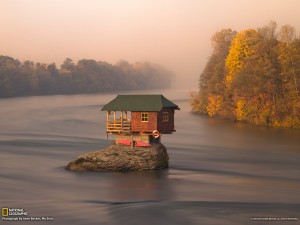
I saw this little dwelling and its location and immediately fell in love with it. It is isolated; it is near water; it even has a boat (note the kayak beneath the house). I still ride a bicycle, so why not paddling a kayak into old age? Perfect location for me.

The photograph is by Irene Becker for National Geographic Picture of the Day: A Tiny River House in Serbia. The website says:

A house in the middle of the Drina River near the town of Bajina Basta, Serbia. The Drina is a 346 km long river that forms much of the border between Bosnia and Herzegovina and Serbia. It is the longest tributary of the Sava River and the longest karst river in the Dinaric Alps.

i searched via Google Earth and finally found the location at latitude 43°59’3.73″N, Longitude 19°33’59.67″E (Google Earth KML file with several more photos of the house). Continue reading Lightkeeper Retirement Homes

Reprint – Photo Gallery: Sutton Bridge Lighthouse Renovation Restores View Which Inspired Sir Peter Scott

Work continues on the Peter Scott Lighthouse near Sutton Bridge - owners Sue and Doug Hilton. Picture: Matthew Usher.

Photo gallery: Sutton Bridge lighthouse renovation restores view which inspired Sir Peter Scott

By DAISY WALLAGE Monday, July 30, 2012
– with permission from EDP24 online

With an endless sky, tantalising glimpses of the The Wash and wildfowl flying overhead, this stunning, sometimes lonely view was lost for decades as time took its toll on east bank lighthouse at Sutton Bridge.

Now, after months of loving restoration, visitors can finally climb to the top and bask in the uninterrupted views that so inspired the artist and conservation pioneer Sir Peter Scott more than 70 years ago.

The view from the top. Picture: Matthew Usher.

Owners Sue and Doug Hilton bought the lighthouse, on the mouth of the River Nene, in November 2010 and are steadily achieving their goal of opening a museum and visitor centre at the site as well as restoring the landmark tower itself.

New, locally crafted steel handrails on the lighthouse stairs will allow visitors to explore beyond Sir Peter’s living room to his second floor bedroom and the lamp room during a series of open weekends next month. Continue reading Reprint – Photo Gallery: Sutton Bridge Lighthouse Renovation Restores View Which Inspired Sir Peter Scott