Category Archives: Search & Rescue

Mise Tales Thirty-Five


For an update on what a Mise Tale is then please see Mise Tales One.

Britain StormsJanuary 07, 2014 – People watch and photograph enormous waves as they break, on Porthcawl harbour, South Wales, Monday Jan. 6, 2014. (AP Photo/PA, Ben Birchall) . . . more

[private]

LONDON — What used to be Winter Storm Hercules has moved across the Atlantic and is now hammering the United Kingdom with high winds and winter weather.. Britain’s western coast is being lashed by high winds and strong rains following a month of unusually frequent winter storms.

A steady procession of storms has battered the island nation over the past few weeks, making December the windiest since 1969. Monster waves up to 27 feet (8.3 meters) high washed across the British coast on Monday, prompting evacuations and rescues.

“This latest storm actually originated as Winter Storm Hercules in the U.S. just after the New Year’s holiday,” said weather.com Senior Meteorologist Jon Erdman.

(MORE: Dangerously Cold Temperatures Hit U.S.)

The nearly non-stop storms have crumbled long-standing sea cliffs and damaged waterfronts.

“It’s been one after the other with no break,” Nicola Maxey, a spokeswoman for Britain’s Meteorological Office, said Tuesday.

More than 100 flood warnings remain across England and Wales.

“This latest Atlantic storm will slowly wind down and weaken over the Norwegian Sea off Scandinavia through Tuesday, giving way to a well-deserve reprieve from the stormy barrage the rest of the work week,” said Erdman.

Heavy winds and rain have also battered the French coast, driving large waves into southwestern town of Biarritz on Tuesday. [/private]

************************ Continue reading Mise Tales Thirty-Five

Ship Movements – It Keeps Getting Better!

On August 08, 2013 I wrote Canadian Firm Tracks Earth’s Ships From Space which also refers to another 2012 article What Ship Is That? Now we have an even better program, free, and online, called Marine Traffic.

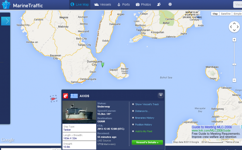
Live Ships Map   AIS   Vessel Traffic and Positions   AIS Marine Traffic(1)

The screen shot above of Marine Traffic for 05:30 UTC (Z) for November 30, 2013 shows the freighter Axios (bottom left) off my area, Negros Oriental Island, Philippines, heading for Guam.

With this  free program you can locate ships in your area, determine their destination, speed, nationality, etc., and even see a photo of the ship.

The program shows Vessels, Ports, Lights, and Aerial Photos of the ports. The “Lights” portion lists and shows photos of navigation lights and lighthouses in the areas.

If one is interested in the sea, vessel traffic, ships, lights, or just navigation, this program is for you. Please take a look here at MarineTraffic.com.


Reprint – A Sailor’s Journal

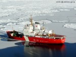
LaurierThe Canadian Coast Guard (CCG) carries lighthouse keepers and their supplies (groceries, mail, household goods, etc) usually by ship or helicopter. This story describes the inner workings of the Canadian Coast Guard light icebreaker Sir Wilfrid Laurier as told by my friend Abe Van Oeveren. I have been on several ships and they are indeed a complicated piece of machinery run by very competent men and women.

Abe’s comments to me about the story when I asked permission to reprint:

The account is based on material gathered on several trips blended together to make a story that flows end to end. To make it readable I avoided talking about too much crappy weather which keeps everybody on board the ship unable to fly up to Van, Naden or Barry, or how the ship’s crew’s collective mood changes as the 28 day typical patrol proceeds.  Continue reading Reprint – A Sailor’s Journal

Canadian Firm Tracks Earth’s Ships From Space

In 2012 I wrote an article called What Ship Is That? which listed a group of programs for tracking ships worldwide. Why would one want to do that? For myself I like to keep track of what ships are sailing on my home coast (the Philippines right now) or for that matter, on the British Columbia coast (my old workplace). It is interesting and informative to anyone that lives on or by the sea. The following story came in from CBC News:

Canadian firm tracks Earth’s ships from space
Data mining with tiny satellites offers new business opportunities
By Emily Chung, CBC News Posted: Aug 12, 2013 5:33 AM ET Last Updated: Aug 12, 2013 12:59 PM ET
 hi-852-ship-aground-00659755-8col.jpg

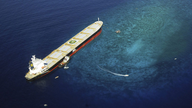
ExactEarth’s data allows authorities to monitor whether ships are following maritime traffic laws or straying into protected areas. For example, it could have provided visual data on the Panamanian-registered ship MV Double Prosperity, which ran aground and destroyed a large portion of a marine sanctuary in Sarangani Bay in 2011. (Sarangani Information Office, Cocy Sexcion/Associated Press)

More information here.

[private]

Want to know the location of every freighter and cruise ship plying the Earth’s oceans? That data isn’t easy to get, but a Canadian company can sell it to you, thanks to its view of the Earth from space.

Since 2010, Cambridge, Ont.-based exactEarth Ltd. has been “mining” data about shipping traffic on Earth using satellites — a technique that could potentially be used to collect other, new kinds of valuable data.

‘The ultimate goal is to build out a cluster of businesses around this platform.’—Glenn Smith, Communitech

“Until we started doing this…you had little bits of information, but you really didn’t have a complete domain awareness of what’s out there,” said Philip Miller, the company’s vice president of engineering and operations.

“Once a ship leaves the shore, essentially they’re a sovereign entity …. A captain can go where he wants. And from shore you didn’t know what was happening unless you contacted the ship and asked — whereas now we’re watching, and we know where they go.”

100,000 ships per day

ExactEarth sells information about the more than 100,000 ships it detects per day to over 50 customers on five continents, including ports, navies and governments.

The data can be used for a wide variety of applications, such as:

  • Identifying and tracking ship traffic through specific areas, such as the Arctic routes that are opening up as the sea ice melts
  • Monitoring whether ships are following maritime traffic laws or straying into protected areas
  • Detecting illegal fishing and piracy, or coordinating search-and-rescue operations during natural disasters.

Last year, the company doubled its customer base, doubled its revenues from $4.8 million to $9.6 million and had total order bookings of about $13.6 million, according to the 2012 financial report from its parent company, COM Dev, a satellite equipment maker that trades publicly on the Toronto Stock Exchange.

COM Dev predicted that by the end of 2013, exactEarth would become “a positive contributor to our cash flow.”

Not designed for detection from space

ExactEarth gets its marketable data by detecting over five million messages a day from automatic identification system (AIS) signals that passenger ships and ships over 300 tonnes (Class A vessels) are required to send out under international law.

The VHF radio signals, mandated by the International Maritime Authority since 2002 to reduce the risk of collisions, provide information about a vessel’s course, speed, position, size, destination and identification to nearby ships and monitoring and navigation stations. ExactEarth can also detect signals from some smaller vessels that use a lower-powered version of AIS.

ExactEarth detects five million messages a day from more than 100,000 ships around the world. ExactEarth detects five million messages a day from more than 100,000 ships around the world. (exactEarth)

AIS was designed for close-range communication and not for detection from space, Miller said.

But such detection was plausible — satellites have the ultimate bird’s eye view of Earth, without the obstructions that get in the way on the surface. Our eyes can spot thousands of car headlights and streetlights from an airplane, but with the right detectors, satellites in space can scan a wide area as they orbit and detect signals that have relatively short ranges on Earth.

Miller said ExactEarth started at a time when smaller satellites — suitcase-sized or smaller as opposed to car- or bus-sized — were starting to become more available and affordable. COM Dev began looking for things that it might be able to detect from space with such satellites, beyond traditional environmental monitoring and imaging.

In collaboration with the University of Toronto’s Institute for Aerospace Studies Space Flight Laboratory, the company launched a satellite in 2008 to prove it could detect AIS from space.

Glenn Smith of Communitech and Robert Zee of UTIAS Space Flight Laboratory hold a life-sized replica of a nanosatellite like one they will be launching in collaboration with exactEarth next year to provide more timely information about ships near the equator. Glenn Smith of Communitech and Robert Zee of UTIAS Space Flight Laboratory hold a life-sized replica of a nanosatellite like one they will be launching in collaboration with exactEarth next year to provide more timely information about ships near the equator. (Emily Chung/CBC)

ExactEarth began commercial service in 2010, using satellite technology from other suppliers. It launched two additional satellites of its own in 2011 and 2012.

ExactEarth’s satellites aren’t the only AIS detectors in space — Rochelle Park, N.J.-based Orbcomm sells data subscriptions similar to ExactEarth’s and already has AIS satellites in both equatorial and polar orbit. Norway launched its AISSat-1 in 2010 and the German Aerospace Center DLR’s AISSat is scheduled to blast off on an Indian launcher later this year.

Miller said most AIS satellites process a lot more data on the satellite than exactEarth’s do, making them substantially different.

“By doing the processing on the ground, we cannot only do more processing, but we can also evolve it over time,” he said, adding that it’s difficult to change anything that’s already in space.

New kinds of data to mine

Some organizations are now interested in trying to mine other types of data from space.

Satellites like those launched by ExactEarth have the ultimate bird's eye view of Earth, without the obstructions that get in the way on the surface. With the right detectors, they detect signals that have relatively short ranges on Earth, the way our eyes can spot thousands of car headlights and streetlights from an airplane. Satellites like those launched by ExactEarth have the ultimate bird’s eye view of Earth, without the obstructions that get in the way on the surface. With the right detectors, they detect signals that have relatively short ranges on Earth, the way our eyes can spot thousands of car headlights and streetlights from an airplane. (ExactEarth)

For example, DLR is currently testing a satellite that detects aircraft signals called ADS-B, which are somewhat similar to AIS. If it works, it will allow continuous monitoring of aviation routes, including areas without radar stations, such as the poles, where airplanes are currently untrackable from the ground.

In Canada, the Waterloo Region’s startup incubator Communitech is collaborating with exactEarth and UTIAS on a project called Data.base, which aims to use exactEarth’s expertise to expand Canada’s “data mining from space” industry.

In 2012, the collaboration received $6.4 million from the federal government to:

  • Research new applications and markets for the technology that exactEarth has developed to collect, package and view satellite data;
  • Work with other businesses that might be interested in getting into the area;
  • Improve the satellite technology; and
  • Design and develop new software.

“The ultimate goal is to build out a cluster of businesses around this platform,” said Glenn Smith, director of digital media projects management at Communitech.

Data.base thinks that AIS technology can be used outside the shipping agency to track other things. The technology to transfer data between Earth and space securely may be useful to industries such as finance, to transfer sensitive data from place to place on Earth via a satellite in space.

Smith said the group has already had discussions with a number of businesses and “there’s definitely a lot of interest.”

For its part of the collaboration, UTIAS is developing a new 15-kilogram microsatellite with a beefed-up power system that will produce and transmit more data more quickly, for both exactEarth and other companies doing similar work, said Robert Zee, managing director of the space flight lab.

Upcoming nanosatellite launch

Meanwhile, exactEarth wants to improve its detection of the weaker AIS signals of Class B ships and its ability to scan ships near the equator more frequently.

Currently, the company’s satellites are in polar orbit — in the same plane as the north and south poles — and can view only a small part of the equator each time they circle the Earth. That means there are “gaps of multiple hours” where ships near some areas of the equator will not be detected, Miller said.

To address that, exactEarth will launch a new seven-kilogram nanosatellite satellite, built by UTIAS, into orbit around the Earth’s equator. EV-9, which may incorporate some of the new technology that exactEarth is working on with its collaborators, will piggyback into space on the launch of a larger satellite. That launch was originally scheduled for this summer, but is now delayed until early 2014.

The new satellite will allow exactEarth to collect updated data about ships near the equator at least once per hour.

That will allow exactEarth to mine more data more quickly. But as in conventional mining, that’s just the first step.

It’s the refining of the data back on Earth that generates a marketable product that clients will pay for.

“You can collect all this data, and it’s valuable,” Miller said. “But you have to turn it into information and knowledge.”

AIS provides information about a vessels' course, speed, position, size, destination and identification to nearby ships. ExactEarth can detect the AIS signals from space and use them to track individual ships, as in this data from Sept. 2011. AIS provides information about a vessels’ course, speed, position, size, destination and identification to nearby ships. ExactEarth can detect the AIS signals from space and use them to track individual ships, as in this data from Sept. 2011. (exactEarth) [/private]


Lightkeepers to the Rescue – AGAIN!


This is a past and very notable lifesaving rescue by two BC lightkeepers, Lynn Hauer and assistant lightkeeper Wolfgang Luebke who were at Chatham Point lighthouse at the time.

******************************

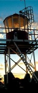
Chatham point lighthouse - photo from Margaret Lutz

We sleep with the radios always on, and ‘with one ear open’.

At 3 AM on April 30, 2012 I was awakened by the unmistakeable sound of a Mayday distress signal. Being able to copy both sides of the communication, I knew it was within our response area. I sprang out of bed. Comox Coast Guard Radio was responding to the call from a very concerned woman, “We don’t have a lifeboat; we are putting our life jackets on now. We are bailing but it isn’t helping!!”

I knew we could be there in 10 to 20 minutes; we were tasked by Rescue Coordination Center. Assistant lightkeeper Wolfgang Luebke and I responded in our 18 foot aluminum station boat. It was pitch black out, and raining. We made our way by compass bearing, across Johnstone Strait into Burgess Passage.

Arriving on scene, we found a man and woman frantically bailing water with ice cream pails! Their bilge pump was inoperative. Their efforts were futile. Their ‘kicker’ motor was under water, and the large outboard was next. Water was pouring in around the re-boarding gate and inches from flooding completely over the transom, which would have seen them go down in minutes. We began pumping the water out of their vessel, with the Honda pump that is always stored under the seat of our station boat. We were all very relieved to see the flood water level slowly subsiding.

Cape Palmerston

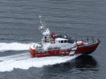
The Cape Palmerston (CG SAR vessel) arrived on scene approximately 40 minutes after us. We saved an $80K boat from going to the bottom, and we surely saved a man and his wife from drowning; they would have been in that frigid water with only PFDs, for more than a half hour, had two keepers from Chatham Point Light not been there…we wouldn’t have been there if not for your SEEING THE LIGHT!

Lynn Hauer

*************************************

This letter was from from Lynn Hauer, a lightkeeper at Chatham Point and it was addressed to Canadian senator Nancy Greene, hence the reference to Seeing the Light. Senator Greene and her friends were very important in fighting to keep BC lighthouses manned. If unmanned, these people would probably have died. Many instances happen daily where a BC lightkeeper helps a mariner. Many of them you will never read about as they go into station reports and are lost in the central Coast Guard office paperwork – well, not actually lost, just suppressed.

The only way for the lightkeepers to get attention is to report their rescues to the Press (forbidden) or have it written up by myself, or other people outside the arm of Coast Guard censorship.

As Lynn said in a preface to the email she passed around to the lighthouse keepers:

It is important to keep the Senators up to speed of things that are going on. They support lightkeepers (LKs), we should keep them in the loop. They and the public recognize and care about what LKs do.

***************************

The following emails show how the email  was received by Senator Greene.

Dear Lynn,

First, thank you for your quick action!  You are so right.
Thanks also for passing this on to me. I will circulate it as best I can.
All the best!
Nancy
 

Thank you so much Nancy.
Your recognition means very much to Wolfgang and I. The thank you that we received from the couple that night, we extend to you.

Lynn, Ann, and Thyr


Lighthouse History – 51 (1927-02-04 – 1927-06-29)

The following extracts taken from early Victoria, British Columbia (BC) newspapers are credited to Leona Taylor for her excellent work in indexing the papers. Full information can be found here: ”Index of Historical Victoria Newspapers“, 2007-09.

Please Note: December 20, 2012 – I am continuing the series with this Lighthouse History #51 because the newspapers have now been indexed up to 1932. I quit posting at #50 as the extracts only went to 1926. They have now been extended from 1927 to 1932 so I will sift through the data for anything lighhouse! So far, a lot of it appears to be obituaries.

Henry Georgeson, 91, retired keeper of Active Pass lighthouse died Feb 3. [funeral Feb 10, 12…] [Colonist, 1927-02-04, p. 4]


Died May 9, 1927 at V, Captain James Christensen, 86. Resident here in 1864, aged 21, born in Denmark. He worked his way out in a cargo ship from Liverpool. Here he tried shore pursuits until he joined Surprise as mate, and in that capacity in 1869 came in contact with the loss of US bark John Bright, off Hesquiat… [see earlier accounts] 
Christensen was afterwards on schooner Alert, with Captain William Spring, and continued trading on the West Coast for some years. He was a pioneer in the sealing trade. His last journey to the west coast was to take material for the erection of Cape Beale lighthouse in 1876. He was successively in command of Beaver, Pilot, tugs Alexander and Lorne, and in 1891 became pilot for Victoria and Nanaimo districts [8 years]. 
In 1868 he married Mary Linklater, and leaves son, Andrew. His other son, Captain James Christensen, succeeded him as commander of Lorne and afterwards ran other tugs out of Victoria until 1894. In that year he lost his life with all the crew of steamer Estelle, which foundered off Cape Mudge. IOOF. Pallbearers: Captains J E Butler and J Gosse, E More, J Woodriff, W McKay, R Lawson. May 11, 14 – How Captain Christensen Conquered the Doubters… Family plot, H 093b094 E 23. [Colonist, 1927-05-08*] Continue reading Lighthouse History – 51 (1927-02-04 – 1927-06-29)

Reprint – DFO Shutting Down Coast Guard Radio Stations, but Prince Rupert’s Will Be Expanded


I wrote an article on January 04, 2012 entitled MCTS To Lose Staff To Save Money. After that date, the department of Fisheries and Oceans (DFO or F&O) have changed their plans. They are now closing whole stations instead of a removing a few men! The news article below is well written and explains what is planned for the BC coast. If all goes through we will have only two (2) MCTS stations on the whole BC coast, relying on mountaintop repeaters to reply to ships at sea.

I can also see soon that their plans will include again trying to de-staff the lighthouses. Pretty soon the whole BC coast will be bare of any support for boaters!

***********************************

By Alan S. Hale – The Northern View
Published: May 18, 2012 4:00 PM
Updated: May 18, 2012 4:59 PM

The Coast Guard communication monitoring station in Prince Rupert will be even more important to ensuring the safety of seafarers. The Prince Rupert station will be one of only two “modernized” coast guard stations in the entire province – the other one being in Sydney. Continue reading Reprint – DFO Shutting Down Coast Guard Radio Stations, but Prince Rupert’s Will Be Expanded

The Lightkeepers by Graham Chandler

Originally published in the January/February 2007 issue of Legion Magazine

We hadn’t expected gourmet Hungarian goulash served up on Royal Doulton china. But at the Cape Scott light station on the remote northwestern tip of Vancouver Island–a place that is normally engulfed in wet grey and storms–today is an exception. The sky is azure, there’s not a puff of wind, and Principal Keeper Harvey Humchitt and his partner Assistant Keeper Todd Maliszewski have house guests.

After sweating through 24 kilometres of squishy rain forest trails we’re no match for the fine linens and silver flatware spread impeccably before us on the dining table. The trek through the forest is the only way to get here without a boat or helicopter. After a couple of greeting barks from their dog Lady, Humchitt welcomes us to Cape Scott. Continue reading The Lightkeepers by Graham Chandler

Minnie Patterson and the “Coloma” off Cape Beale 1906

– Reprinted  courtesy of The Department of Fisheries and Oceans Canada

Cape Beale - photo Justine Etzkorn

Cape Beale, . . . a lighthouse which later came to notice in a gallant and romantic rescue resulting from the actions of Mr. and Mrs. Paterson who kept the light from 1895 to 1908.

In December 1906, the United States barque Coloma left the Puget Sound with a cargo of lumber for Australia. There was a gale from the southeast and, cracking on to take advantage of this fair wind to clear the Straits of Juan de Fuca, the old wooden vessel sprang a leak when she encountered a heavy sea off Cape Flattery. With her decks awash, and the gear aloft carrying away as she pitched in an enormous swell, the Coloma was soon unmanageable and hoisted her ensign upside down in token of distress as she drifted down to leeward and the outlying reefs of Cape Beale.

In this position, and doubtless having let go her anchors to the bitter end, the barque was sighted from the lighthouse. The only chance of help lay in alerting the Quadra, then under the command of Captain Charles Hackett, which Paterson knew was lying at anchor in Bamfield Inlet, six miles away. The lifeboat, it will be recalled, was not on station at Bamfield until the following year. Telephone lines were down and the light keeper was unable to leave his foghorn which required constant attention. Although the trail was blocked by fallen trees and lay for much of the distance along a rocky shore. Mrs. Paterson at once insisted on making the journey herself. It was then night, and in darkness and dreadful weather she set off with a lantern and her dog, hoping against hope to be in time.

The plan was to get the news to James Mackay at Bamfield who would row off to the Quadra and raise the alarm. Arriving at the house physically exhausted, drenched to the skin and with her shoes and clothing ripped to pieces, it was found that Mackay was away from home repairing the telephone wires. Nothing daunted, Minnie Paterson and Mrs. Mackay themselves launched the boat and came alongside the Quadra as daylight came. Captain Hackett weighed anchor at once and the Quadra punched her way out of the Inlet against a heavy swell rolling in from the Pacific. Off Cape Beale the wreck was sighted, a boat was lowered under the command of the second officer Mr. James E. McDonald, and the distressed crew were recovered. No sooner had the boat returned to the Quadra than the derelict parted her cables and drove ashore to destruction. Mr. McDonald was promoted to chief officer shortly afterwards.

Immediately after her courageous action, and before the return of the Quadra with the shipwrecked men, Mrs. Paterson walked all the way back to the lighthouse. She had five children to look after and her husband was constantly at work in a period of rain and bad visibility. It was another week before communications were restored, and only then did the Paterson’s learn of the triumphal rescue which had resulted. Unfortunately, the results of Mrs. Paterson’s tremendous exertion soon made themselves apparent and she never entirely recovered, dying five years later.

More information and photos here on the Tofino History website.

Lighthouse Time-Keeping

Originally I had this article titled as Lighthouse Time referring to the time we were required to be at work on the station. Lighthouse Time-Keeping (leading up to automation) is a better phrase as it reflects punching the clock, etc. which we did not actually have do on a lighthouse. Someone was always there. You never left a lighthouse alone.

On the lighthouse we worked to get the job done. When it was done we could relax. We were on watch all the time. 

In the early days (1800s – 1950s) the lighthouse was a one family station and if an assistant was required for heavy work then it was up to the keeper to hire a person from the local community using his own wages to pay the person. The keepers hours of duty were long and hard and were broken only when the wife was free to help out. Two man and/or family stations were only on very isolated stations with keepers on duty approximately twelve hour shifts but usually longer. Actually, at that time, no shifts were set down on paper – the station had to be manned no matter what. 

In the 1950s to 1970s the stations with more duties, equipment, or isolation had an extra man so there were one-, two- and three-man stations. These people were on duty at differing hours. A one-man station required the keeper to sometimes sleep in the engine/fog alarm room when heavy fog was prevalent for days on end. In the mid 1960s the two-man stations had a shift time of twelve hours each man and three-man stations eight hours each. The early 1970s saw some automated equipment installed and most three-man stations reduced to two-man and a susequent increase in the number of hours on duty without an increase in pay. 

Late 1970s brought more talk of automation, more equipment, especially station monitoring equipment for automation, but no increase in the keeper’s pay. In fact the first closing of some stations was started, automation equipment was put in place and keepers were ignored.

Finally by the mid 1980s a job description was given to the lighthouse keepers and this would be what their wages were based on – more duties, more pay.

Keepers were requested to submit a list of the duties they performed and the time involved. But only Coast Guard related work was to be on the list. All the extra work the lightkeeper did was not recorded – jobs such as weather reporting, sea water samples, search and rescue, bird and animal surveys, pollution watch, radio watch, etc. This, according to the Coast Guard was not the job of a lighthouse keeper. 

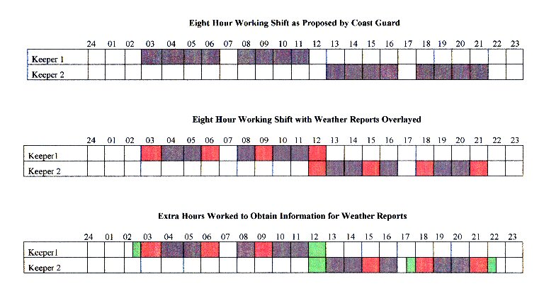
Again in the mid 1980s, automation in Ottawa computers and on the lights designated that we had to have hours of work laid down. Up to that time we were paid a yearly wage divided by the number of government paydays in a year (52). This gave us our bi-monthly wage. Divided by the number of hours we were on duty (for seven days a week you must remember), this worked out to very much less than the minimum wage at the time. Finally the government worked out that we would all have an eight hour shift each, during daylight hours and they worked it out this way:

As you can see the by the first table the shifts were 8 hours long in two periods as we were supposed to ignore the station during our one hour break at lunch and breakfast and supper.

The second table shows that weather reports did not fit into this shift pattern at lunchtime.

The third table shows the extra quarter hour (or half hour, depending on the intensity of weather) we used to make the observations and record all afterwards. The result was a normal nine- to ten-hour day but we were only listed as working eight.

What the government did not include was overtime! We had an eight hour shift to work. Finished! They did not consider the times when we were phone in the night for weather reports, where one had to dress, go outside, read the barograph and write-up the weather; or the nights where we baby-sat a boat in distress because Coast Guard radio was tied up with so many incidents because of bad weather; or the nights the engines shut down because of bad fuel delivered to us; or the time the main light blew out twice in a row; or the time the battery went dead on their automatic engines and shut down the station (the battery controlled the control panel) – I can list hundreds of times we worked through the nights, but all on an eight hour shift!

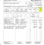
Pay Stub

You will notice on the pay stub (left) the highlighted number 56 under “Hours of Work”. This is eight hours a day for seven days (8 hours X 7 days = 56 hours). You can also see by the shift chart that daylight hours (which were imposed to stop us collecting shift differential1) were an impossibility unless you were working in the summer above the Arctic Circle! 

But, there was a good side. We worked as we wished. No office supervisor and no daily logging in and out. We could work twelve hours here and then go fishing for four hours, always mindful of the radio, the weather, engines, fog, and the light. We could work a morning shift and spend the next eight hours unloading a supply ship (no overtime) and then hit the sack. Next day we could take it easy! Only the weather reports at 3AM , 6AM, 9AM, Noon, etc. 

But then the Coast Guard decided that we had to report exactly what we were doing! They issued us with log books and a new set of rules and we were supposed to log everything we did during our shift!

Well we filled the books with every little detail we performed. Contrary to our job description we included all the local, marine, synoptic, special and extra weathers. All the radio contacts, all the ship contacts, all the jobs done and listed every minute of the shift. We filled reams of books and sent them into the office every month. It didn’t help us, didn’t help them, but gave us an extra entry in the logbook “0900-0910 Filling out logbook”! 

Present day (November 2006) the Coast Guard removed most of the foghorns (no monitoring), lowered or changed the intensity of the lights, removed range lights, removed radio beacons and their towers, removed weather equipment such as barometers, wind recorders, etc., and removed from the lightkeepers duties most weather reporting details so that they have become glorified groundskeepers.

But rest assured, as long as the government lets them remain on duty, they will come to your assistance with a radioed weather report, a can of gas or a friendly hello. God Bless all lighthousekeepers!

*************************************

FOOTNOTES:

1Shift Differential – Additional pay for work regularly performed outside normal daytime hours, usually defined as before &AM and after 6PM.