Category Archives: Tourism

Mise Tales Twenty-Seven


For an update on what a Mise Tale is then please see Mise Tales One.

I found two new lighthouses – not manned, but not in my lists. One is:

ViajeTierraSanta-Portugal-Cascais1


The Santa Marta Lighthouse and Museum located in Cascais, Portugal


[private]

SANTA MARTA LIGHTHOUSE MUSEUM BY AIRES MATEUS, CASCAIS, PORTUGAL

1 March 2010 | By Catherine Slessor

  • Poised on  a rocky promontory, the array of new and refurbished structures clusters round the base of the lighthouse
Previous thumbnails

  • Poised on  a rocky promontory, the array of new and refurbished structures clusters round the base of the lighthouse
  • The warped cuboids frame a promenade overlooking the harbour
  • New parts are simple white volumes, like pieces of crisply folded paper
  • Existing structures are clad in tiles so they become mute and abstracted
  • The site, prior to remodelling, showing the existing buildings
  • The bright outside walls belie the dark interior spaces
  • Inside the  museum café
  • Exhibition spaces possess theatrically dark interiors

Next thumbnails

A highly poetic abstract exploration for Portugal’s first lighthouse museum. Photography by Fernado Guerra

Some time before Eduardo Souto de Moura’s Paula Rego museum (AR November 2009) added the coastal town of Cascais to the gazetteer of Portuguese contemporary architecture, Aires Mateus put a marker down with the Santa Marta Lighthouse Museum. Though a smaller project and one that involved melding together historical fragments with new interventions, nonetheless it resonates intimately with site and place while exploring a highly poetic language of rigour and abstraction.

Based in Lisbon, Francisco and Manuel Aires Mateus are brothers who graduated in successive years in the late 1980s from the Technical University of Lisbon’s architecture faculty. Both worked with Gonçalo Byrne before establishing their own practice while still only in their mid-twenties. The pair epitomise an emerging generation of Portuguese architects who are now making the transition to becoming more fully established. This project, for Portugal’s first (and possibly only) museum dedicated to lighthouses, represents a consolidation of familiar ideas and ambitions – the play of mute, austere volumes, a heightened sensitivity to materials and the notion of served and servant spaces.

Poised on a rocky promontory, the array of new and refurbished structures clusters round the base of the lighthouse

Portugal’s coast is studded with relics of its rich seafaring history. Set on a rocky promontory near Cascais’ harbour, the site was once a 17th-century fortress that formed part of the town’s maritime defences. During the 19th century, the fortress lost its strategic importance and a lighthouse was built to aid commercial shipping. Poised on the tip of the promontory, the striped, pepper-pot structure is topped by a small glass beacon. Now automated but still operational, the lighthouse anchors the site and forms the focus of the museum.

Clustered around its base is an ensemble of three existing buildings now refurbished to house new exhibition spaces and an auditorium.Though the simple geometry of each structure is still legible, they are wrapped in a uniform carapace of glossy white tiles and effectively transformed into abstract representations of their original historic selves.The tiles are laid slightly unevenly so the apparently plain surfaces catch the light and have a subtle iridescent quality.

The white exteriors conceal a theatrically dark inner realm, with exhibits – old lighthouse beacons, maritime paraphernalia, maps and photographs – set against black walls, floors and ceilings.

A new single-storey volume extends along the west edge of the site, framing a pleasant promenade with views over the harbour and sea. This new part contains the museum’s servant spaces – café, offices and WCs linked by a circulation spine. Here the orthogonal geometry is subverted, with each function precisely articulated in a sculptural extrusion, so that the building resembles a folded and twisted piece of origami. Walls are rendered white, rather than tiled, with large, vitrine-like windows set flush in the smooth surfaces.

Though the ostensible simplicity of two different kinds of white buildings might be easily apprehended by Portugal’s relatively unsophisticated construction industry, this is still admirably nuanced architecture. Its effect lies in considered subtleties: how materials are juxtaposed, how light is handled and how site connects with history and place.

Architect Aires Mateus 
Structural engineer Joel Sequeira
Services engineer Joule

[/private]

and

gásadalur village in the faroe islands
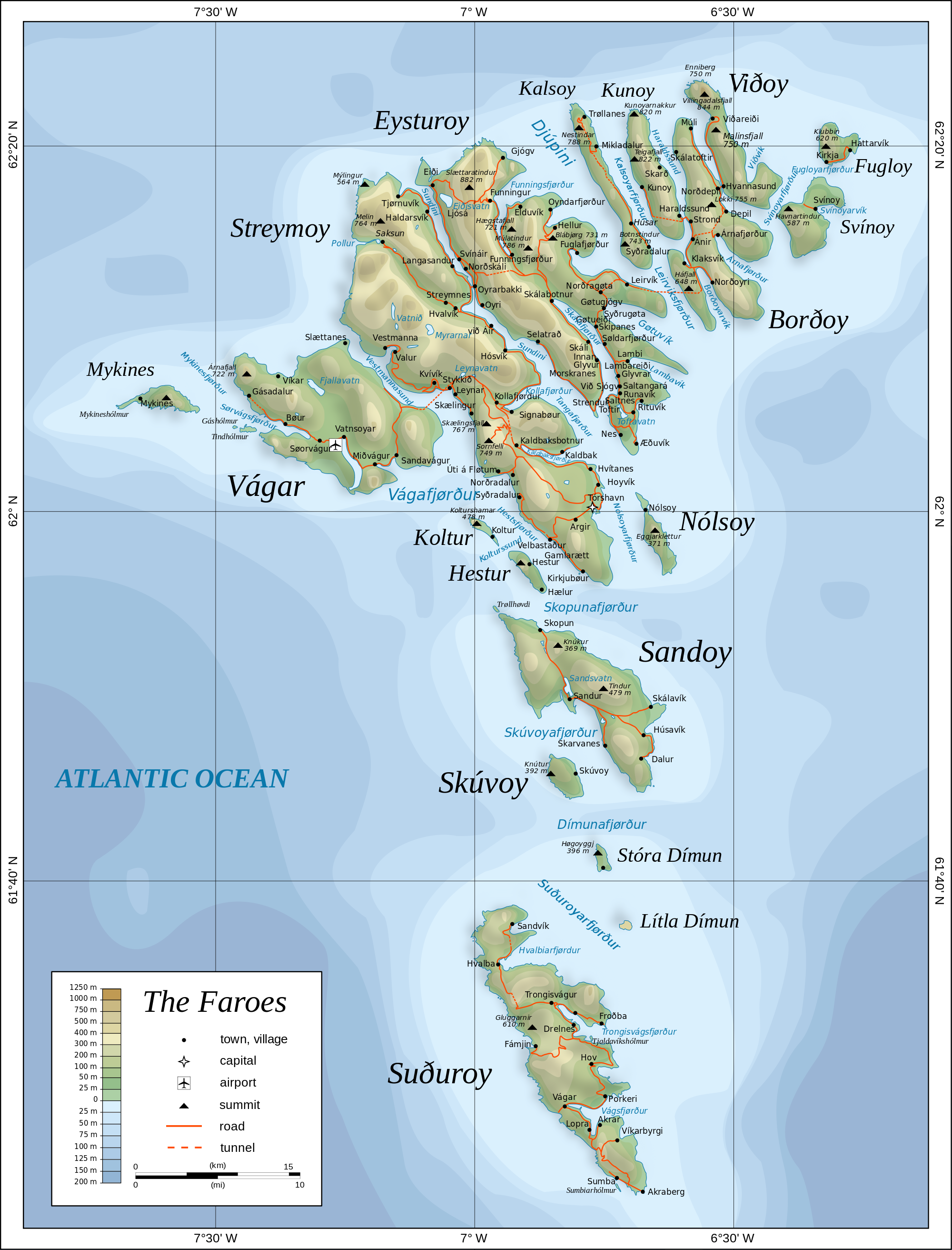
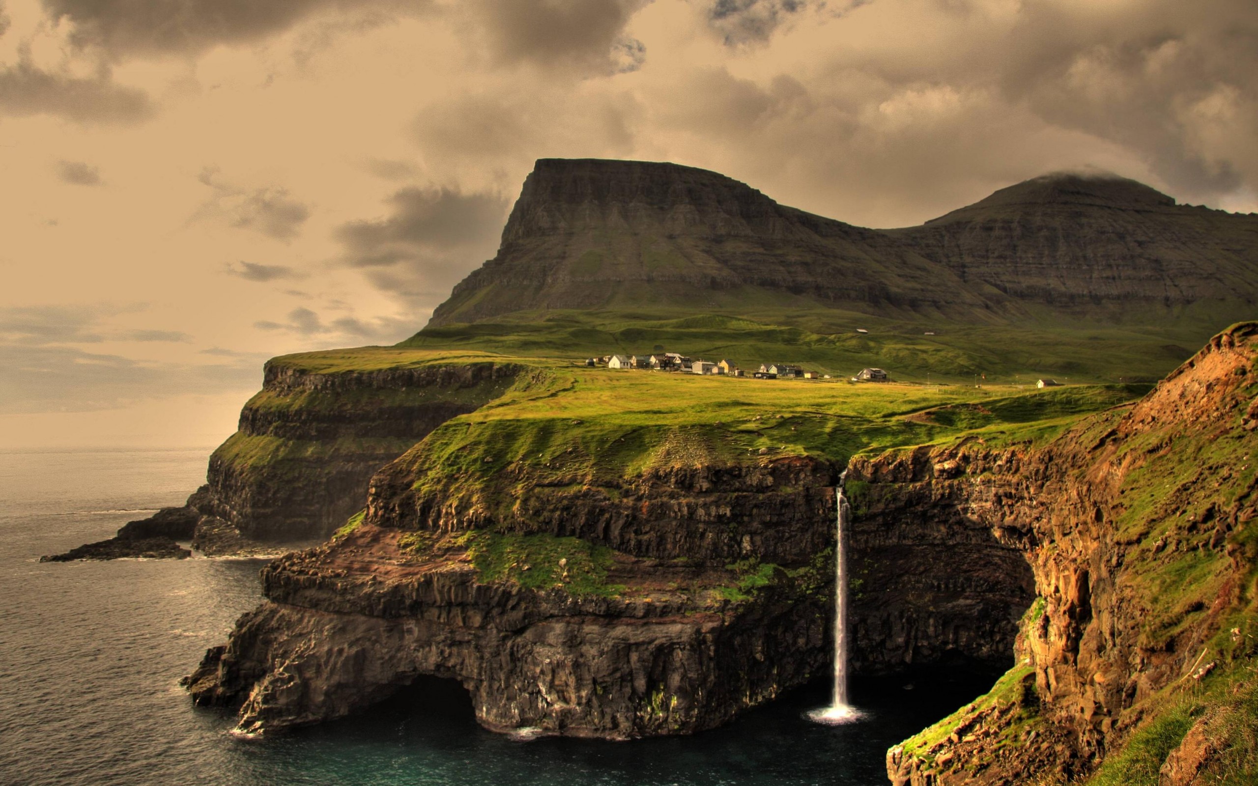
One on the Faroe Islands island of Vágar near this photo of  Gásadalur village. One of two lighthouses on the island is located SE of the village on the entrance to the Sørvágsfjørd, which leads to the fishing port of Sørvágur on the southwest coast of Vágar. Located on a bluff on the south side of the fjord about 4 km (2.5 mi) west of Sørvágur. 


Map_of_the_Faroe_Islands_en.svg


I was going to post the above beautiful village photo on my page of Fantasy Lighthouses which will be coming up, but then I discovered it had an actual lighthouse of its own. How cool is that?                        

 ***************************

 And to round things out, my recent story on Night Photos and the Lighthouse had some fantastic photos, but then this one below came to my attention, and I bring it to yours. It is St. Catherines Lighthouse on the Isle of Wight – beautiful photo.

st catherines isle of wight

Tidelines and Ocean Currents

Tidelines – it is spelled both ways but I prefer the one-word form.

A tideline, according to Wikipedia

refers to where two currents in the ocean converge (or meet). Driftwood, floating seaweed, foam, and other floating debris may accumulate, forming sinuous lines called tidelines.

Two-rivers-that-meets-but-do-not-mixThe topic of this article came about after I saw the photo above.The photo actually shows two oceans meeting, but is similar to what happens with the tides on the ocean further south, especially with reference to the Pacific Ocean on the Canadian British Columbia (BC) coast where the tides change (from high to low and back again) twice a day – sometimes rising and falling by as much as seven (7) meters (22 feet)! Continue reading Tidelines and Ocean Currents

Mise Tales Twenty-Six


For an update on what a Mise Tale is then please see Mise Tales One.

August 26, 2013 Vancouver Sun

Keeping the light on at Point Atkinson

Pt.Atkinson

 When the Point Atkinson lighthouse was built 130 years ago, it was designed to protect shippers in the Strait of Georgia. Now the lighthouse itself is in need of a benefactor. . . . more


[private] Keeping the light on at Point Atkinson


 VANCOUVER SUN AUGUST 26, 2013
  
Keeping the light on at Point Atkinson
 

The Point Atkinson Lighthouse at Lighthouse Park in West Vancouver stands guard at the mouth of Burrard Inlet May 11, 2004.

Photograph by: RIC ERNST , PNG

When the Point Atkinson lighthouse was built 130 years ago, it was designed to protect shippers in the Strait of Georgia. Now the lighthouse itself is in need of a benefactor.

The Department of Fisheries and Oceans and the District of West Vancouver are discussing ways to put the lighthouse into the hands of the community after Point Atkinson — along with 18 other B.C. lighthouses — was deemed “surplus” to the federal government’s needs three years ago and offered up for sale or transfer.

“In reflection, (the federal government) realized some of the national historic sites aren’t going to go to the highest bidder,” said Brent Leigh, deputy chief administrative officer at the District of West Vancouver, which has a co-management agreement with the government to maintain the lighthouse.

“They expect to work with the district in a community-based program that would ensure that we retain community use … Point Atkinson is one of our most beloved community assets.”

Originally built on a rocky cliff in 1875, the lighthouse has been more than just a beacon of hope for shippers over the centuries. It has also recorded a series of historical firsts as time went on, as chronicled in the book Keepers of the Light, written by one of the last lightkeepers, Donald Graham:

1774: Captain Vancouver rows past the point and names it for a ”particular friend.”

1872: The Marine Department awards contract to Arthur Finney to build the lighthouse.

1875: New lighthouse exhibits fixed white light illuminated by two coal oil lamps and silver-plated copper reflectors.

1875: Edwin Woodward and his wife land at the station.

1876: James Atkinson Woodward, the first white child born in West Vancouver, is born there.

1881: 185-acre park created as a Lighthouse Reserve.

1889: Scotch siren fog signal, powered by a coal-generated steam plant installed to help shippers navigate the fog.

1912: Original tower replaced by 60-foot-high concrete tower. Light replaced by a vaporized oil lamp.

1960: Vaporized oil lamp replaced by electric light bulb.

1994: Lighthouse designated a National Historic Site.

1996: Point Atkinson refitted with an automated solar-powered light.

Donald Graham and Gerry Watson were the last lightkeepers. Graham’s wife Elaine still lives in the cottage at Lighthouse Park.

With files from Canadian Lightkeepers Association website

© Copyright (c) The Vancouver Sun [/private]
 
*************************** Continue reading Mise Tales Twenty-Six

Something Even Better?

alberta-fire-lookout
photo – Stuart Gradon Calgary Herald

Something Even Better than working on a lighthouse?

In an email with an ex British Columbia (BC) lighthouse keeper he mentioned that he was going to work in Alberta, Canada as a Fire Tower Lookout!

What does that have to do with lighthouses?

A lot from many people’s perspective! Both jobs have the isolation and romance that a lot of people seek in a job. When I was younger I know it was always in the back of my mind.

Again the same questions pop up – Wouldn’t it be lonely? What about wild animals? What happens if you hurt yourself? These and many more questions are asked, but to the adventurous, it is part of the adventure. Anyways, take a look at the photo at the top – that is an Alberta lookout tower but not as you or I probably imagined it – sitting on the ground!

The photo is taken from a 2011 story by Calgary Herald reporterJamie Komarnicki Mystery and mountains: A look at Alberta forest fire spottersContinue reading Something Even Better?

Doug Clement Photography

All photos copyright by Doug Clement Photography, and used with permission.

Doug is a professional artist, videographer and photographer. He is a lifetime resident of Victoria and has been capturing its beauty on film for over 30 years. – from the Facebook page

Lightning at Trial Island
Lightning at Trial Island © Doug Clement Photography

In my teenage years while attending High School and University, and before I moved onto the lighthouses, I lived in Victoria, British Columbia (BC), Canada (on southern Vancouver Island off the West Coast of BC). It was a delightful town to grow up in and had access to numerous beaches, parks and believe it or not, a few lighthouses, of which I was not interested at that time.

Just recently on Facebook I have seen some wonderful photography of the lighthouses in and around Victoria, BC by Doug Clement. He has given me permission to publish them here, I hope that in your first or next trip to Victoria, you get a chance to see these places. If not, please admire them in the photos by Doug Clement. 

The first photo above shows Trial Island Lighthouse at night with a blast of lightning. The actual light of the lighthouse is the greenish glow on the right side while the red lights are  warning  lights for aircraft mounted on the radio towers on the island (see the last photo in this story).

Here is a link to a Google Map showing the Trial Island Lighthouse, above photo (yellow point on map) and Ogden Point Breakwater light, photo below (red point on the map). Continue reading Doug Clement Photography

Haida Gwaii

Queen_Charlotte_Islands_Map
Haida Gwaii Map

Haida Gwaii (High-Da Gwi my pronunciation) literally means “Islands of the Haida People”, informally but formerly known as the Queen Charlotte Islands (QCI) and the Charlottes, is an archipelago on the North Coast of British Columbia, Canada, populated mostly by first nations Haida people.

Langara Point Lighthouse

Langara Point Lighthouse courtesy of Langara Fishing Adventures on Flickr Continue reading Haida Gwaii

The West Coast Trail

 90527barr18

The West Coast Trail is a 75 km (47 mi) long backpacking trail following the southwestern edge of Vancouver Island in British Columbia, Canada. It was built in 1907 to facilitate the rescue of survivors of shipwrecks along the coast, part of the treacherous Graveyard of the Pacific. It is now part of Pacific Rim National Park (Parks Canada and Wikipedia) and is often rated by hiking guides as one of the world’s top hiking trails.

The West Coast Trail is open from May 1 until September 30. It is accessible to hikers outside of this period but Parks Canada does not guarantee the accessibility of services (such as search and rescue) in the off season. It was originally known as the Dominion Lifesaving Trail (sometimes misidentified as the West Coast Lifesaving Trail).-Wikipedia

*************************

Video courtesy of Parks Canada website

*************************

1044857_10151761979494553_1816265077_n

My daughter and her friend just finished hiking the West Coast Trail this Summer 2013 and thoroughly enjoyed it. (photos on Facebook) It is rough, it is challenging, but it is an adventure, and it is fun! The trail passes by two manned lighthouses (Pachena -photo above, and Carmanah – photo below) which date back to the time when the trail was Continue reading The West Coast Trail

Where Does Beach Sand Come From?

My wife asked me the other day “Why is there more sand here after the river floods?”. I explained that because it was a mountain river, the flooding caused more rocks to grind together and tumble down from the hills grinding themselves eventually into fine sand.

In my article Reprint – A Grain of Beach Sand – Photography Book by Gary Greenberg I showed photos of grains of sand, some formed  from stones, shells, etc.

A more detailed explanation of the source of sand and why it is different colours I found in this article from the Live Science website called:

By Adam Hadhazy, Contributor   |   July 16, 2013 06:00am ET
beach-sea-130716 (1) 
Why does sand look and feel the way it does?
Credit: Beach photo via Shutterstock

Summer wouldn’t be complete without a trip to the sandy shores of an ocean, bay, lake or river. As the gritty stuff gets in between your toes, you may wonder why beaches are distinctive sandy stretches and why sand looks and feels the way it does.

And then again, you might not — you didn’t come to the beach to think, did you? But for those in an asking mood, a sandy beach is essentially where pulverized, weathered rock along with some fragments of shelled creatures and other biota have collected, tossed up by the waves and as sediment from inland areas. More . . .

[private]

“Sand is basically the material you get when you get a breakdown in rocks, when the rocks weather and decompose over hundreds of thousands and millions of years,” said Jeff Williams, senior scientist emeritus for the U.S. Geological Survey Woods Hole Science Center. [Stunning Sands Gallery: A Rainbow of Beaches]

 Sand grits it out

Not every rocky mineral is equally built to last. So, over time, the weathering process yields certain common compositions for sand as the stronger materials persist. 

“Some of the minerals are very unstable and decompose, while others such as feldspar, quartz and hornblende are more stable,” said Williams. “They’re harder, more resistant minerals, and so they tend to stay behind.”

These minerals — abundant in Earth’s crust — in ground-up form constitute a lot of the sandy particles comprising beaches. “Probably the most common composition would be quartz sand with some feldspar,” said Williams.

This mineral formula gives beaches that sort of typically, well, “beachy” complexion of a light brown found in many places in the continental United States and elsewhere. “The iron staining on the quartz and iron oxide on the feldspar gives the sand that tan or brownish color, but this varies greatly,” Williams told LiveScience.

Indeed, every beach is essentially a product of its regional and local environment, and is accordingly one-of-a-kind. [In Photos: The Top 10 Beaches of 2013]

“The sand on each beach is like a fingerprint — it’s unique to the particular beach where you find it,” said Williams. “The sand’s unique composition, color and grain size are a result of the source rocks it came from, but also a result of coastal processes that modify the sand over long periods of time.”

Examples of these processes include the types of waves and currents in an area, as well as the sea level history for that particular coast.

A sandy rainbow

All of these variables intermix to create wildly different-looking beaches, depending on location. For example, in the Florida panhandle, Williams noted, the sand is often very white because of its high quartz content over feldspar and hornblende.

purple beach sand
This beautiful photo of Pfeiffer Beach in Big Sur, Calif., was taken on June 12, 2010. The sand gets its plum color from manganese garnet particles that wash down from the hillside that overlooks the beach.
Credit: Mariusz Jurgielewicz | Dreamstime

Farther south around Miami, the sand also trends fairly white, but for a completely different reason: A significant amount of the sand particles there are made of calcium carbonate, or the tiny bits of fragmented shells from sea life.

Tropical regions have more of this shell-derived sand than temperate regions, where the sand is mostly silica-based in the form of quartz.

Williams pointed to some other neat examples. “Many of the beaches in Bermuda have not only white sand but have pink or reddish sand particles as well,” he said. The origin of this famous coloration is the remains of tiny, single-celled creatures called Foraminifera that have pink or reddish shells.

Hawaii, meanwhile, is well-known for its black sand beaches, the result of ground-up, dark volcanic rocks. Some beaches on Hawaii’s Big Island even have a greenish tint, thanks to the presence of the mineral olivine.

Old beach, new beach

As a final sandy thought, consider the fact that the sand on most of our beaches, especially on the East and Gulf Coasts, is rather old: some 5,000 years or so, Williams said. Very little new sand reaches the coast nowadays from the continental interior as it once did.

malibu-beach-erosion
Beach erosion is threatening some of Malibu’s most exclusive oceanfront property..
Credit: Cedric Weber / Shutterstock.com

The construction of roads, dams, and so on, is one reason. “Development along the coastline sort of impedes the transport of sand from the interior to the coast,” said Williams.

The other major reason is a general rise in sea levels over the past approximately 12,000 years, which has flooded river valleys and created large estuaries such as Charleston Harbor, the Chesapeake Bay, Delaware Bay and the Hudson River. These estuaries trap would-be sand before it reaches the coast, Williams explained.

As a tie-in, the erosion of beaches especially after major storms often requires beach nourishment, or replenishment projects. Sand is dredged up from offshore and deposited on the shoreline to rebuild lost real estate.

Williams noted that these projects, while often successful, must contend with the different characteristics of sand one can get even in very close vicinities. “You have to pay careful attention to the aesthetics,” said Williams. “People like to have the same sort of material on the beach as the native beach.”

[/private]

Chrome Island – a few photos for you

I received the following email from a friend on August 12, 2013:

“Pictures of Chrome Island Lighthouse taken by Bruce’s
sister-in-law  from Bruce’s brother’s living room at their home in Bowser, BC.”


View Chrome Island in a larger map
 
If you view the larger map you can see the points I have placed on the map showing Bowser, BC (the photographer’s home – green point) and Chrome Island Lighthouse – red point). I estimate the distance to be about three (3) kilometers.
 
 [nggallery id=74]
 
I wish more people would send me photos of their favourite lighthouses. These are great! Continue reading Chrome Island – a few photos for you

Mise Tales Twenty-Five


For an update on what a Mise Tale is then please see Mise Tales One.

Charm_BraceletEdgartown Lighthouse Charm Bangle

The first colony on Martha’s Vineyard, Edgartown is known primarily for its preserved 19th century seaport, picturesque harbor, and whaling traditions. Depicted on an Expandable Wire Bangle, the Edgartown Lighthouse is a beacon of light for generations of sailors and a popular point of interest for all seasonal guests. 

divider_faedust

 Can You Believe This?

During those times [late 1870s] lighthouse keepers were never supposed to leave the property unattended day or night, summer or winter, and the Dodges faithfully abided by that regulation for all of the years they were there which ended up being 51 years. More . .  Continue reading Mise Tales Twenty-Five